|
Marloes Wesselink
Marloes Wesselink (born 14 April 1987) is a Dutch professional beach volleyball player born in Doetinchem. She played indoor volleyball for a few years, playing at Orion Doetinchem, Sourcy Volleybalschool and Longa'59 Lichtenvoorde before she switched onto the beach. She had never played volleyball at the beach before but she was invited to it when she was a member of the Sourcy Volleybalschool. In 2003 and 2004 she played with several teammates, but mostly played with Angelique Remmers. They achieved some decent results and Wesselink felt a potential future in this sport. When teaming up with Marleen van Iersel in 2005 their skills improved fast, which resulted in a successful season. They started off in the Eredivisie of Beach volleyball in the Netherlands, which is the highest league in the country. In Callantsoog they became second and in Assen they reached the 3rd position. Their first World Tour event was in Gstaad finishing 57th among the World's best teams. In the E ... [...More Info...] [...Related Items...] OR: [Wikipedia] [Google] [Baidu] |
Doetinchem
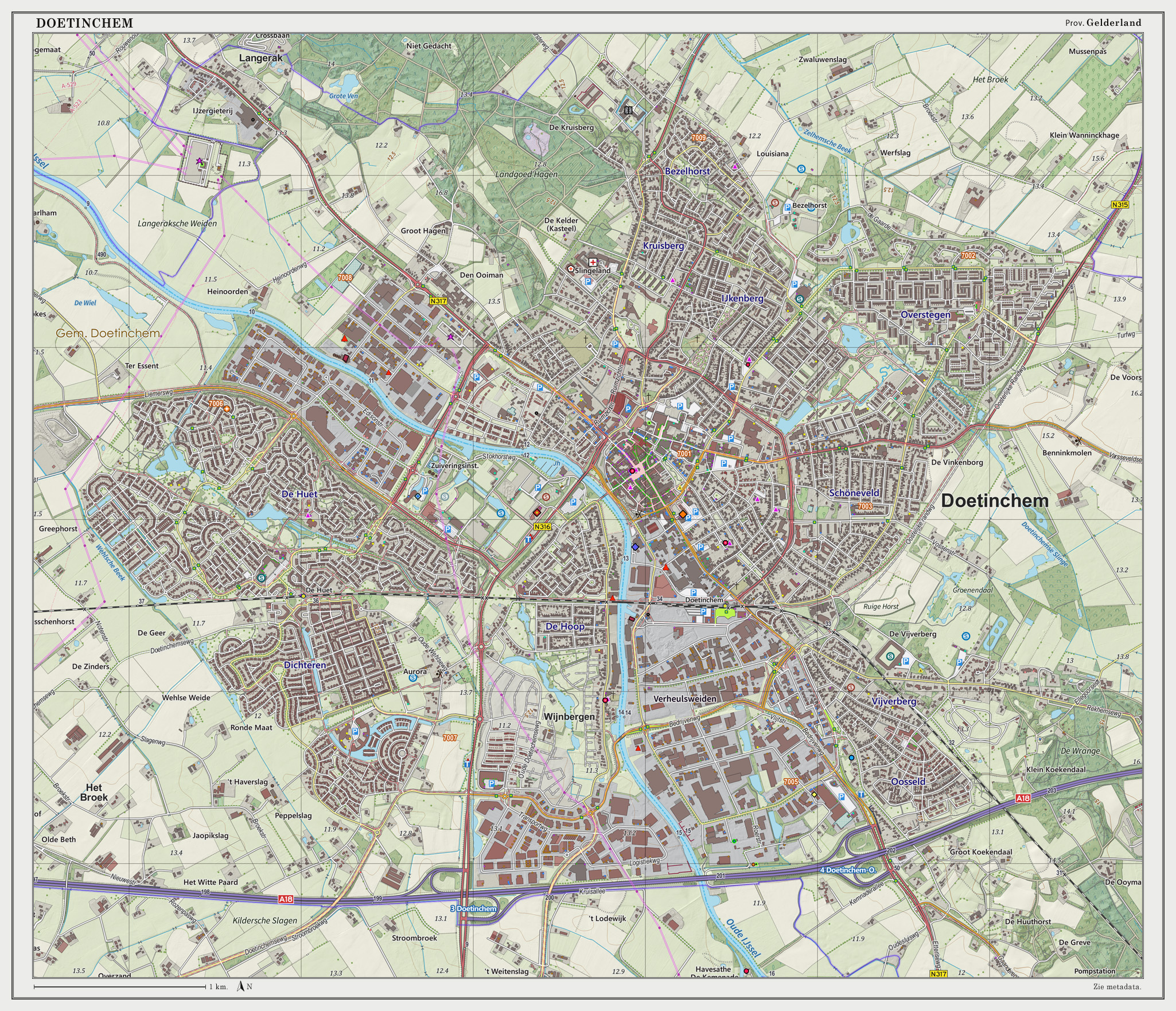
Doetinchem (; Low Saxon: ) is a city and municipality in the east of the Netherlands. It is situated along the Oude IJssel (Old IJssel) river in a part of the province of Gelderland called the Achterhoek. The municipality had a population of in and consists of an area of of which is water. This makes Doetinchem the largest town (by population) in the Achterhoek. On 1 January 2005, a municipal restructuring merged the neighbouring municipality of Wehl as well as the Zelhelmse Broek area with Doetinchem. Population centres The local government organization in the Netherlands is complex and fine-grained (see municipality and Govt Stats, with municipalities being divided into various entities. The municipality of Doetinchem consists of: The city ('stad'): * Doetinchem The neighborhoods ('wijken'): * Centrum * Bezelhorst * Dichteren * Overstegen * De Huet * De Hoop * Oosseld * Schöneveld & Muziekbuurt The townships ('buurtschappen'): * Gaanderen * Wehl * IJzevoorde * Lan ... [...More Info...] [...Related Items...] OR: [Wikipedia] [Google] [Baidu] |
Nesselande
Nesselande is a new extension on the east side of the city of Rotterdam, in South Holland, the Netherlands. It is part of the borough of Prins Alexander, formerly Zevenhuizen-Moerkapelle. Nesselande consists of three development areas: Tuinstad, Badplaats and Waterwijk. On the south side, located near the A20 motorway, there is a modest business park which forms a logical buffer between the motorway and the housing. Within the new development, an ecological park A park is an area of natural, semi-natural or planted space set aside for human enjoyment and recreation or for the protection of wildlife or natural habitats. Urban parks are urban green space, green spaces set aside for recreation inside t ... known as ''Rietveldpark'' provides for natural elements. Line B of the Rotterdam Metro was extended to the area in 2005. {{Authority control Neighbourhoods of Rotterdam ... [...More Info...] [...Related Items...] OR: [Wikipedia] [Google] [Baidu] |
Poland
Poland, officially the Republic of Poland, is a country in Central Europe. It is divided into 16 administrative provinces called voivodeships, covering an area of . Poland has a population of over 38 million and is the fifth-most populous member state of the European Union. Warsaw is the nation's capital and largest metropolis. Other major cities include Kraków, Wrocław, Łódź, Poznań, Gdańsk, and Szczecin. Poland has a temperate transitional climate and its territory traverses the Central European Plain, extending from Baltic Sea in the north to Sudeten and Carpathian Mountains in the south. The longest Polish river is the Vistula, and Poland's highest point is Mount Rysy, situated in the Tatra mountain range of the Carpathians. The country is bordered by Lithuania and Russia to the northeast, Belarus and Ukraine to the east, Slovakia and the Czech Republic to the south, and Germany to the west. It also shares maritime boundaries with Denmark and Sweden. ... [...More Info...] [...Related Items...] OR: [Wikipedia] [Google] [Baidu] |
South Korea
South Korea, officially the Republic of Korea (ROK), is a country in East Asia, constituting the southern part of the Korea, Korean Peninsula and sharing a Korean Demilitarized Zone, land border with North Korea. Its western border is formed by the Yellow Sea, while its eastern border is defined by the Sea of Japan. South Korea claims to be the sole legitimate government of the entire peninsula and List of islands of South Korea, adjacent islands. It has a Demographics of South Korea, population of 51.75 million, of which roughly half live in the Seoul Capital Area, the List of metropolitan areas by population, fourth most populous metropolitan area in the world. Other major cities include Incheon, Busan, and Daegu. The Korean Peninsula was inhabited as early as the Lower Paleolithic period. Its Gojoseon, first kingdom was noted in Chinese records in the early 7th century BCE. Following the unification of the Three Kingdoms of Korea into Unified Silla, Silla and Balhae in the ... [...More Info...] [...Related Items...] OR: [Wikipedia] [Google] [Baidu] |
Valencia (city In Spain)
Valencia ( va, València) is the capital of the autonomous community of Valencia and the third-most populated municipality in Spain, with 791,413 inhabitants. It is also the capital of the province of the same name. The wider urban area also comprising the neighbouring municipalities has a population of around 1.6 million, constituting one of the major urban areas on the European side of the Mediterranean Sea. It is located on the banks of the Turia, on the east coast of the Iberian Peninsula, at the Gulf of Valencia, north of the Albufera lagoon. Valencia was founded as a Roman colony in 138 BC. Islamic rule and acculturation ensued in the 8th century, together with the introduction of new irrigation systems and crops. Aragonese Christian conquest took place in 1238, and so the city became the capital of the Kingdom of Valencia. The city's population thrived in the 15th century, owing to trade with the rest of the Iberian Peninsula, Italian ports and other locati ... [...More Info...] [...Related Items...] OR: [Wikipedia] [Google] [Baidu] |
Marseille
Marseille ( , , ; also spelled in English as Marseilles; oc, Marselha ) is the prefecture of the French department of Bouches-du-Rhône and capital of the Provence-Alpes-Côte d'Azur region. Situated in the camargue region of southern France, it is located on the coast of the Gulf of Lion, part of the Mediterranean Sea, near the mouth of the Rhône river. Its inhabitants are called ''Marseillais''. Marseille is the second most populous city in France, with 870,731 inhabitants in 2019 (Jan. census) over a municipal territory of . Together with its suburbs and exurbs, the Marseille metropolitan area, which extends over , had a population of 1,873,270 at the Jan. 2019 census, the third most populated in France after those of Paris and Lyon. The cities of Marseille, Aix-en-Provence, and 90 suburban municipalities have formed since 2016 the Aix-Marseille-Provence Metropolis, an Indirect election, indirectly elected Métropole, metropolitan authority now in charge of wider metropo ... [...More Info...] [...Related Items...] OR: [Wikipedia] [Google] [Baidu] |
Hamburg
(male), (female) en, Hamburger(s), Hamburgian(s) , timezone1 = Central (CET) , utc_offset1 = +1 , timezone1_DST = Central (CEST) , utc_offset1_DST = +2 , postal_code_type = Postal code(s) , postal_code = 20001–21149, 22001–22769 , area_code_type = Area code(s) , area_code = 040 , registration_plate = , blank_name_sec1 = GRP (nominal) , blank_info_sec1 = €123 billion (2019) , blank1_name_sec1 = GRP per capita , blank1_info_sec1 = €67,000 (2019) , blank1_name_sec2 = HDI (2018) , blank1_info_sec2 = 0.976 · 1st of 16 , iso_code = DE-HH , blank_name_sec2 = NUTS Region , blank_info_sec2 = DE6 , website = , footnotes ... [...More Info...] [...Related Items...] OR: [Wikipedia] [Google] [Baidu] |
Kijkduin
Kijkduin en Ockenburgh is a Dutch subdistrict of the Loosduinen district in The Hague. The subdistrict is located in the western part of The Hague at the municipal border of Monster. The area is bordered by the North Sea, an imaginary line between beach pole 105 and the De Savornin Lohmanlaan, the Machiel Vrijenhoeklaan, the Duinlaan, the Kijkduinsestraat, the Ockenburghstraat, the Loosduinse Hoofdstraat, the Monsterseweg and the municipal border with Monster. As the name suggests, the subdistrict consists of two neighborhoods Kijkduin and Ockenburgh. History Kijkduin Kijkduin is a seaside resort on the North Sea coast of the province of South Holland in the Netherlands. It is one of the two seaside resorts of the city of The Hague, the other (more famous) one being Scheveningen. "Kijkduin" is quite famous for its long stretch in sand dunes along the coast. In the late 19th century, the seaside resort Kijkduin arose at the narrowest spot in the dunes on the south-western side of ... [...More Info...] [...Related Items...] OR: [Wikipedia] [Google] [Baidu] |
Monster, Netherlands
Monster is a town in the Dutch province of South Holland. It is a part of the municipality of Westland, and lies about south-west of The Hague. The village of Monster has a population of around 11,580.Statistics Netherlands (CBS)''Statline: Kerncijfers wijken en buurten 2003-2005'' As of 1 January 2005. The statistical area Monster, which also can include the surrounding countryside, has a population of around 14,540. Until 2004 it was a separate municipality and covered an area of (of which is water). The former municipality of Monster also included the towns, Poeldijk and Ter Heijde. Monster and Ter Heijde are towns on the North Sea coast and have a popular beach. History In the 13th century a great deal of the Westland, Loosduinen and The Hague were administered by Monster. When The Hague came to be constructed, a split was made in Haag-ambacht and Half-Loosduinen. The latter village was separated from Monster in 1812. Remains of the former glory can still be seen between T ... [...More Info...] [...Related Items...] OR: [Wikipedia] [Google] [Baidu] |
Scheveningen
Scheveningen is one of the eight districts of The Hague, Netherlands, as well as a subdistrict (''wijk'') of that city. Scheveningen is a modern seaside resort with a long, sandy beach, an esplanade, a pier, and a lighthouse. The beach is popular for water sports such as windsurfing and Kitesurfing, kiteboarding. The harbour is used for both fishing and tourism. History The earliest reference to the name ''Sceveninghe'' goes back to around 1280. The first inhabitants may have been Anglo-Saxons. Other historians favour a Norsemen, Scandinavian origin. Fishing was the main source of food and income. The Battle of Scheveningen was fought between English and Dutch fleets off the coast of the village on 10 August 1653. Thousands of people gathered on the shore to watch. Edward Montagu, 1st Earl of Sandwich, Montagu's flagship picked up the English king at Scheveningen in order to accomplish the Restoration (England), Restoration. A road to neighbouring The Hague was const ... [...More Info...] [...Related Items...] OR: [Wikipedia] [Google] [Baidu] |
Almere
Almere () is a Planned community, planned List of cities in the Netherlands by province, city and List of municipalities of the Netherlands, municipality in the Provinces of the Netherlands, province of Flevoland, Netherlands, located about 20 km to the east of Amsterdam (as the crow flies) across the IJmeer. Bordering Lelystad and Zeewolde, the municipality of Almere comprises six official areas that are the districts of Almere Stad (which is further split up into Almere Stad Oost, Almere Stad West and Almere Centrum), Almere Buiten and Almere Pampus (which is currently being designed), and the boroughs of Almere Haven, Almere Hout and Almere Poort. Four of them feature official district or borough offices. Furthermore, it also comprises the unofficial historic district and neighborhood Oostvaardersdiep, which has an active semi-self-governing community, and the planned district of Almere Oosterwold. Almere is part of the Amsterdam Metropolitan Area (MRA). Almere is the newest c ... [...More Info...] [...Related Items...] OR: [Wikipedia] [Google] [Baidu] |


.jpg)

.png)