|
Manas International Airport
Manas International Airport ( ky, Манас эл аралык аэропорту, Manas El Aralyk Aeroportu ; russian: Международный аэропорт «Манас») is the main international airport in Kyrgyzstan, located north-northwest of the capital Bishkek. History The airport was constructed as a replacement for the former Bishkek airport that was located to the south of the city, and named after Kyrgyz epic hero, Manas, suggested by writer and intellectual Chinghiz Aitmatov. The first plane landed at Manas in October 1974, with Soviet Premier Alexei Kosygin on board. Aeroflot operated the first scheduled flight to Moscow–Domodedovo on 4 May 1975. When Kyrgyzstan gained independence from the Soviet Union in 1991, the airport began a steady decline as its infrastructure was neglected for almost ten years and a sizable aircraft boneyard developed. Approximately 60 derelict aircraft from the Soviet era, ranging in size from helicopters to full-sized airl ... [...More Info...] [...Related Items...] OR: [Wikipedia] [Google] [Baidu] |
Bishkek
Bishkek ( ky, Бишкек), ), formerly Pishpek and Frunze, is the capital and largest city of Kyrgyzstan. Bishkek is also the administrative centre of the Chüy Region. The region surrounds the city, although the city itself is not part of the region but rather a region-level unit of Kyrgyzstan. Bishkek is situated near the Kazakhstan–Kyrgyzstan border. Its population was 1,074,075 in 2021. In 1825, the Khanate of Kokand established the fortress of Pishpek to control local caravan routes and to collect tribute from Kyrgyz tribes. On 4 September 1860, with the approval of the Kyrgyz, Russian forces led by Colonel Apollon Zimmermann destroyed the fortress. In the present day, the fortress ruins can be found just north of Jibek jolu street, near the new main mosque. In 1868, a Russian settlement was established on the site of the fortress under its original name, Pishpek. It lay within the General Governorship of Russian Turkestan and its Semirechye Oblast. In 1925, the K ... [...More Info...] [...Related Items...] OR: [Wikipedia] [Google] [Baidu] |
Operation Enduring Freedom
Operation Enduring Freedom (OEF) was the official name used synonymously by the U.S. government for both the War in Afghanistan (2001–2014) and the larger-scale Global War on Terrorism. On 7 October 2001, in response to the September 11 attacks, President George W. Bush announced that airstrikes targeting Al-Qaeda and the Taliban had begun in Afghanistan. Operation Enduring Freedom primarily refers to the War in Afghanistan, but it was also affiliated with counterterrorism operations in other countries, such as OEF-Philippines and OEF-Trans Sahara. After 13 years, on 28 December 2014, President Barack Obama announced the end of Operation Enduring Freedom in Afghanistan. Subsequent operations in Afghanistan by the United States' military forces, both non-combat and combat, occurred under the name Operation Freedom's Sentinel. Subordinate operations Operation Enduring Freedom most commonly referred to the U.S.-led combat mission in Afghanistan. The codename was also used ... [...More Info...] [...Related Items...] OR: [Wikipedia] [Google] [Baidu] |
Ceiling (cloud)
In aviation, ceiling is a measurement of the height of the base of the lowest clouds (not to be confused with cloud base which has a specific definition) that cover more than half of the sky (more than 4 oktas) relative to the ground. Ceiling is not specifically reported as part of the METAR (METeorological Aviation Report) used for flight planning by pilots worldwide, but can be deduced from the lowest height with broken (BKN) or overcast (OVC) reported. A ceiling listed as "unlimited" means either that the sky is mostly free of cloud cover, or that the cloud is high enough not to impede Visual Flight Rules ( VFR) operation. Definitions ; ICAO : The height above the ground or water of the base of the lowest layer of cloud below 6000 meters (20,000 feet) covering more than half the sky. ; United Kingdom : The vertical distance from the elevation of an aerodrome to the lowest part of any cloud visible from the aerodrome which is sufficient to obscure more than half of the sky ... [...More Info...] [...Related Items...] OR: [Wikipedia] [Google] [Baidu] |
ICAO
The International Civil Aviation Organization (ICAO, ) is a specialized agency of the United Nations that coordinates the principles and techniques of international air navigation, and fosters the planning and development of international air transport to ensure safe and orderly growth. ICAO headquarters are located in the '' Quartier International'' of Montreal, Quebec, Canada. The ICAO Council adopts standards and recommended practices concerning air navigation, its infrastructure, flight inspection, prevention of unlawful interference, and facilitation of border-crossing procedures for international civil aviation. ICAO defines the protocols for air accident investigation that are followed by transport safety authorities in countries signatory to the Chicago Convention on International Civil Aviation. The Air Navigation Commission (ANC) is the technical body within ICAO. The commission is composed of 19 commissioners, nominated by the ICAO's contracting states and appo ... [...More Info...] [...Related Items...] OR: [Wikipedia] [Google] [Baidu] |
Instrument Landing System
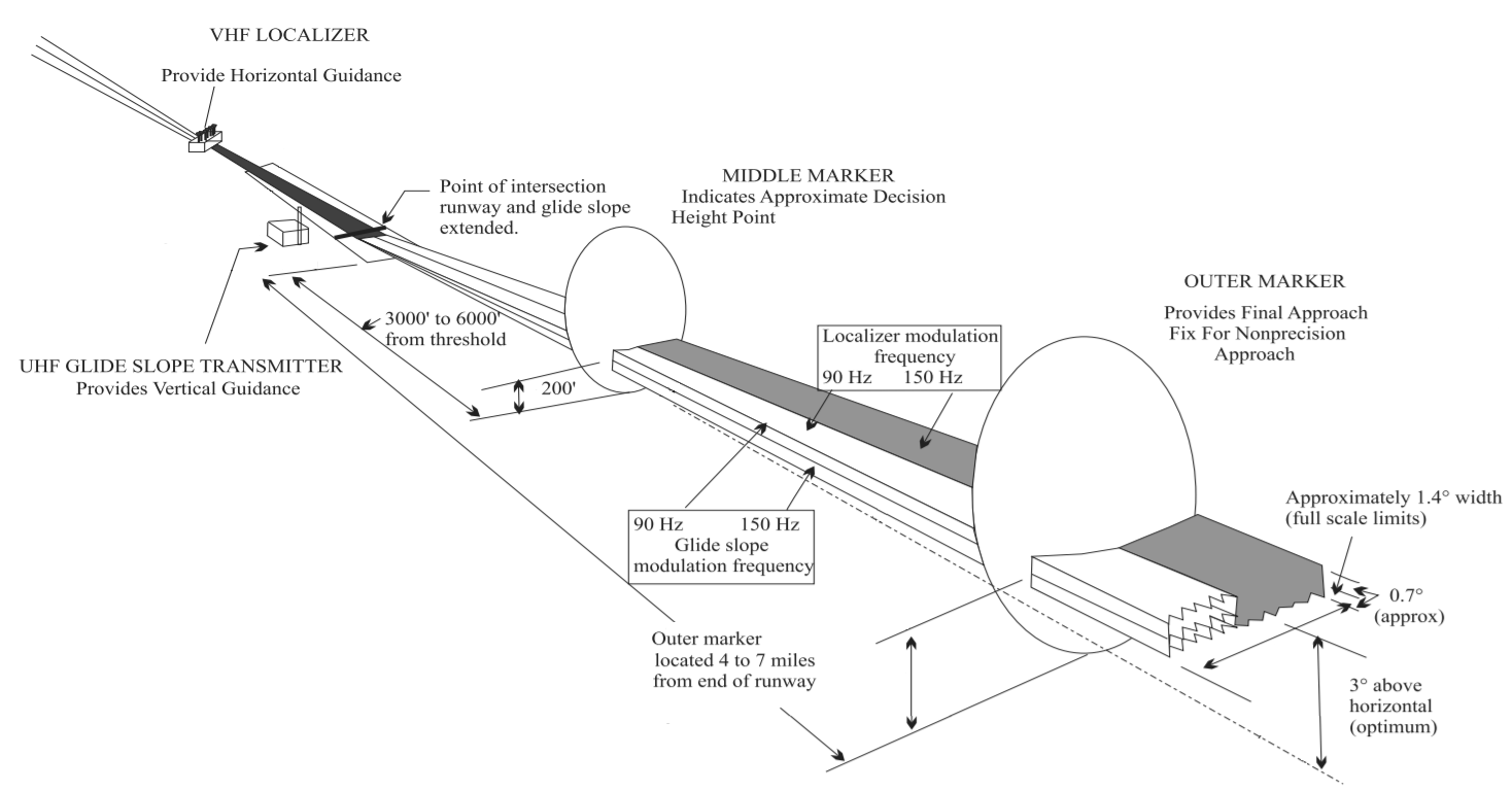
In aviation, the instrument landing system (ILS) is a precision radio navigation system that provides short-range guidance to aircraft to allow them to approach a runway at night or in bad weather. In its original form, it allows an aircraft to approach until it is over the ground, within a of the runway. At that point the runway should be visible to the pilot; if it is not, they perform a missed approach. Bringing the aircraft this close to the runway dramatically increases the range of weather conditions in which a safe landing can be made. Other versions of the system, or "categories", have further reduced the minimum altitudes, runway visual ranges (RVRs), and transmitter and monitoring configurations designed depending on the normal expected weather patterns and airport safety requirements. ILS uses two directional radio signals, the ''localizer'' (108 to 112 MHz frequency), which provides horizontal guidance, and the ''glideslope'' (329.15 to 335 MHz frequency ... [...More Info...] [...Related Items...] OR: [Wikipedia] [Google] [Baidu] |
C-17 Globemaster III
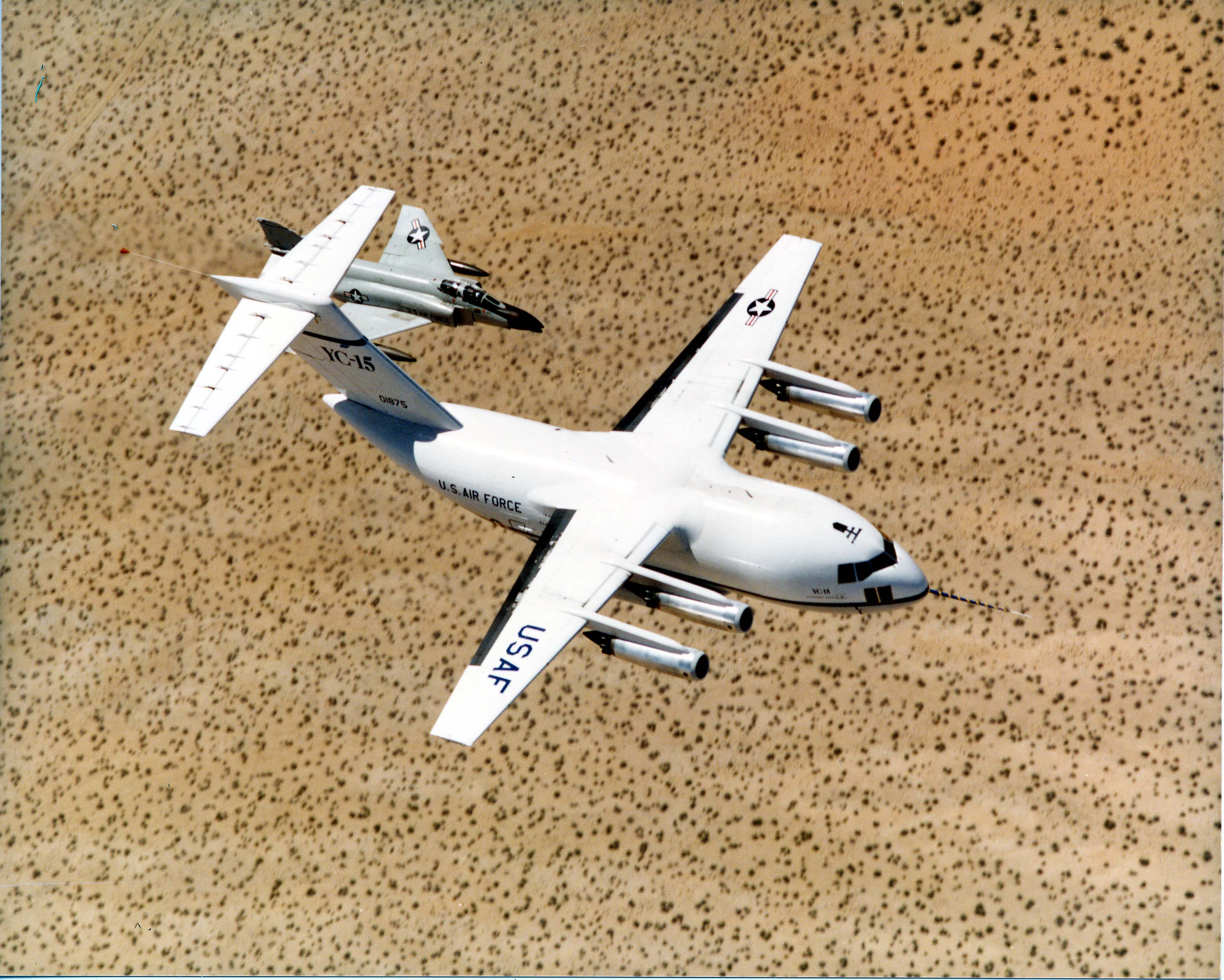
The McDonnell Douglas/Boeing C-17 Globemaster III is a large military transport aircraft that was developed for the United States Air Force (USAF) from the 1980s to the early 1990s by McDonnell Douglas. The C-17 carries forward the name of two previous piston-engined military cargo aircraft, the Douglas C-74 Globemaster and the Douglas C-124 Globemaster II. The C-17 is based upon the YC-15, a smaller prototype airlifter designed during the 1970s. It was designed to replace the Lockheed C-141 Starlifter, and also fulfill some of the duties of the Lockheed C-5 Galaxy. Compared to the YC-15, the redesigned airlifter differed in having swept wings, increased size, and more powerful engines. Development was protracted by a series of design issues, causing the company to incur a loss of nearly US$1.5 billion on the program's development phase. On 15 September 1991, roughly one year behind schedule, the first C-17 performed its maiden flight. The C-17 formally entered USAF service o ... [...More Info...] [...Related Items...] OR: [Wikipedia] [Google] [Baidu] |
KC-135 Stratotanker
The Boeing KC-135 Stratotanker is an American military aerial refueling aircraft that was developed from the Boeing 367-80 prototype, alongside the Boeing 707 airliner. It is the predominant variant of the C-135 Stratolifter family of transport aircraft. The KC-135 was the United States Air Force's first jet-powered refueling tanker and replaced the KC-97 Stratofreighter. The KC-135 was initially tasked with refueling strategic bombers, but it was used extensively in the Vietnam War and later conflicts such as Operation Desert Storm to extend the range and endurance of US tactical fighters and bombers. The KC-135 entered service with the United States Air Force (USAF) in 1957; it is one of nine military fixed-wing aircraft with over 60 years of continuous service with its original operator. The KC-135 is supplemented by the larger McDonnell Douglas KC-10 Extender. Studies have concluded that many of the aircraft could be flown until 2030, although maintenance costs have grea ... [...More Info...] [...Related Items...] OR: [Wikipedia] [Google] [Baidu] |
Transit Center At Manas
Transit Center at Manas (formerly Manas Air Base and unofficially Ganci Air Base) is a former U.S. military installation at Manas International Airport, near Bishkek, the capital of Kyrgyzstan. It was primarily operated by the U.S. Air Force. The primary unit at the base was the 376th Air Expeditionary Wing. On 3 June 2014 American troops vacated the base and it was handed over back to the Kyrgyzstan military. The base was opened in December 2001 to support U.S. military operations in the War in Afghanistan. The base was a transit point for U.S. military personnel coming from and going to Afghanistan. Recreation facilities included internet cafes, wireless internet, pool tables, free video games, and telephone lines via the DSN that allowed coalition forces to call their homes at little or no cost. The base had a large dining facility, a gymnasium, and a chapel. There was also a library where books and magazines were available for active duty airmen. It also hosted for ... [...More Info...] [...Related Items...] OR: [Wikipedia] [Google] [Baidu] |


