|
Möll Valley
The Möll (; presumably from sl, Mel, "rubble") is a river in northwestern Carinthia in Austria, a left tributary of the Drava. Its drainage basin is . Course The river rises in the High Tauern range of the Central Eastern Alps on the Pasterze Glacier at the foot of the Grossglockner, the highest mountain in Austria. It discharges after near Möllbrücke into the Drava. At the beginning of its course, at the southeastern end of the Pasterze Glacier, it is impounded to form the Margaritze Reservoir, from where part of the water is diverted via pressure tunnels across the Alpine crest and Mt. Wiesbachhorn to the reservoirs of the Verbund hydroelectric power plant in Kaprun, Salzburg. The Möll then runs down to Heiligenblut, parallel to the Grossglockner High Alpine Road, and further southwards separating the mountains of the Schober Group in the west from the Goldberg Group in the east. In the municipality of Winklern, near the border with Tyrol (East Tyrol) at Isel ... [...More Info...] [...Related Items...] OR: [Wikipedia] [Google] [Baidu] |
Pasterze Glacier
The Pasterze, at approximately 8.4 kilometres (5.2 mi) in length, is the longest glacier in Austria and in the Eastern Alps. It lies within the Glockner Group of the High Tauern mountain range in Carinthia, directly beneath Austria's highest mountain, the Grossglockner. The length of the glacier is currently decreasing by about 50 m (160 ft) each year. Its volume has diminished by half since the first measurements in 1851. Geography The glacier reaches from its head, the Johannisberg peak at , to above sea level ( m AA). The Pasterze forms the source region of the Möll river, a left tributary of the Drava. Its waters also feed the Margaritze reservoir, used to generate electricity at the Kaprun hydropower plant north of the Alpine crest. The name ''Pasterze'' is possibly derived from sl, pasti, "pasture". Indeed the detection of wood, peat and pollen in the area of the retreating glacier indicate vegetation and also the use as pastureland during the las ... [...More Info...] [...Related Items...] OR: [Wikipedia] [Google] [Baidu] |
Tauern Railway Tunnel
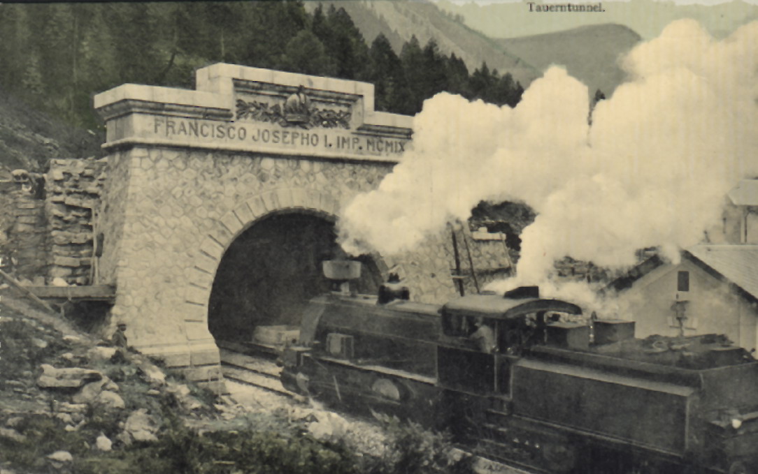
The Tauern Railway Tunnel (german: Tauerntunnel) in Austria is the longest tunnel of the Tauern Railway crossing the main chain of the Alps. Currently, it has a length of . The highest point of the tunnel, which is also the highest point in all of the railway line, is at above sea level. The tunnel's north entrance is at Böckstein in the valley of Bad Gastein in the state of Salzburg, while the south entrance is near Mallnitz in Carinthia. The construction of the Tauern Railway Tunnel was first mooted during the late nineteenth century, although actual work on its construction was started in July 1902. The excavation was performed via a labour intensive process by a mostly Italian workforce overseen by the civil engineer Karl Wurmb. It was effectively finished during 1906, and formally opened three years later by Emperor Francis Joseph of Austria. While trains were initially operated by steam locomotives, the tunnel and wider line alike were electrified during the interwar per ... [...More Info...] [...Related Items...] OR: [Wikipedia] [Google] [Baidu] |
Mallnitz
Mallnitz is a municipality in the Spittal an der Drau District in Carinthia, Austria. Geography It is situated in a high valley of the Hohe Tauern mountain range stretching southwards down to Obervellach on the Möll river and separating the Ankogel Group in the east from the Goldberg Group in the west. In the north the Alpine crest marks the border with the Austrian state of Salzburg. At Mallnitz the Tauern Railway enters into the south portal of the Tauern Tunnel. The municipal area consists of the cadastral communities of Mallnitz proper and Dösen. The northern parts belong to the High Tauern National Park territory. History A trade route across the mountain passes to the Gastein Valley in the north may already existed in the Bronze Age. It was used by the Celts from about 400 BC, and when the area was incorporated into the Roman Noricum province about 15 BC, these bridle paths were rebuilt as a Roman road. A first settlement on the ancient route was probably establishe ... [...More Info...] [...Related Items...] OR: [Wikipedia] [Google] [Baidu] |
Tauern Railway
The Tauern Railway (german: Tauernbahn) is an Austrian railway line between Schwarzach- Sankt Veit in the state of Salzburg and Spittal an der Drau in Carinthia. It is part of one of the most important north-south trunk routes (''Magistrale'') in Europe and also carries tourist traffic for the Gastein Valley. The standard gauge railway line is long and climbs the High Tauern range of the Central Eastern Alps with a maximum incline of 2.5%, crossing the Alpine crest through the long Tauern Tunnel. It is one of the highest standard gauge railways in Europe and the third highest in Austria. History Since the opening of the Suez Canal in 1869, the Cisleithanian government of Austria-Hungary had urged for a direct connection of the restored main Austrian seaport at Trieste with the Bohemian coalfields and iron works in the northern parts of the Monarchy. After lengthy discussions, the building of the ''Tauernbahn'' was set up as a part of the larger "New Alpine Railways" inve ... [...More Info...] [...Related Items...] OR: [Wikipedia] [Google] [Baidu] |
Obervellach
Obervellach ( sl, Zgornja Bela) is a market town in the district of Spittal an der Drau, in the Austrian state of Carinthia. Geography The town is situated in the valley of the Möll river, on the southern slope of the High Tauern mountain range, where the Tauern Railway line descends from neighbouring Mallnitz and the southern Tauern Tunnel portal. The municipal area comprises the cadastral communities of Obervellach proper, Pfaffenberg, Lassach, and Söbriach. History The settlement of ''Velach'' was first mentioned in a 10th-century deed issued by the Bishop Abraham of Freising (d. 993/94), a Bavarian missionary among the East Alpine Slavs in the Duchy of Carinthia (former Carantania), known for the Slovene Freising manuscripts. The name is probably derived from Slavic ''bela'' ("white"). The local church was mentioned as 'Freising basilica' in 1072, it later became the seat of a deanery of the Salzburg archbishops. The traditional gold and silver mining area from the 1 ... [...More Info...] [...Related Items...] OR: [Wikipedia] [Google] [Baidu] |
Stall, Austria
Stall is a municipality in the district of Spittal an der Drau in the Austrian state of Carinthia. Geography Stall lies in the central Möll Valley, between the Goldberg Group on the north and the Kreuzeck Group The Kreuzeck Group is a mountain range of the Central Eastern Alps. It may be considered either a separate range or part of the larger High Tauern chain. Administratively, the range belongs to the Austrian states of Carinthia and, in the western ... on the south. References Cities and towns in Spittal an der Drau District {{Carinthia-geo-stub ... [...More Info...] [...Related Items...] OR: [Wikipedia] [Google] [Baidu] |
Kreuzeck Group
The Kreuzeck Group is a mountain range of the Central Eastern Alps. It may be considered either a separate range or part of the larger High Tauern chain. Administratively, the range belongs to the Austrian states of Carinthia and, in the westernmost part, Tyrol (i.e. East Tyrol). Geography The Kreuzeck Group is geographically separated from the main chain of the High Tauern in the north by the Möll, a left tributary of the Drava, up to the confluence within the Lurnfeld basin in the east. In the south, the Drava forms the border with the Gailtal Alps, part of the Southern Limestone Alps. The Iselsberg Pass near Lienz, connecting the Drava and Möll valleys, marks the western end. The range is mainly composed of gneiss and garnet- mica-schists. The mountainous area (approximately 450 km²) is sparsely populated and used mainly for forestry and hunting. However, its tourism industry has improved in recent years. The area of the Reißeck municipality in the Möll valley is ... [...More Info...] [...Related Items...] OR: [Wikipedia] [Google] [Baidu] |
Iselsberg Pass
The Iselsberg Pass, at , is a high mountain pass in the Austrian Alps between the states of Tyrol and Carinthia. It separates the mountains of the Kreuzeck group in the south from the Schober group in the north, both parts of the Hohe Tauern range. The pass road connects Lienz in East Tyrol with Winklern in the Carinthian Möll valley. A bridle path across the Iselsberg was already built in Roman times, to reach the mines in the Möll valley from ''Aguntum''. The village of Iselsberg is located about 1 km southwest of the summit. See also * List of highest paved roads in Europe * List of mountain passes This is a list of mountain passes. Africa Egypt * Halfaya Pass (near Libya) Lesotho * Moteng Pass * Mahlasela pass * Sani Pass Morocco * Tizi n'Tichka South Africa * Eastern Cape Passes * Western Cape Passes * Northern Cape Passes * Kwa ... {{Authority control Mountain passes of Tyrol (state) Mountain passes of the Alps Mountain passes of Carinthia (s ... [...More Info...] [...Related Items...] OR: [Wikipedia] [Google] [Baidu] |
East Tyrol
East Tyrol, occasionally East Tirol (german: Osttirol), is an exclave of the Austrian state of Tyrol, separated from the main North Tyrol part by the short common border of Salzburg and Italian South Tyrol (''Südtirol'', it, Alto Adige). It is congruent with the administrative district ('' Bezirk'') of Lienz. History The area around the former Roman '' municipium'' of Aguntum was, from the 12th century, held by the Counts of Gorizia, who took their residence at Lienz and inherited the County of Tyrol in 1253. While Tyrol was lost to the Austrian House of Habsburg in 1363, the Gorizian counts retained Lienz until the extinction of the line in 1500. Emperor Maximilian I of Habsburg finally incorporated it into Austrian Tyrol. East Tyrol's present-day situation arose from the defeat of the Austro-Hungarian Empire in World War I and its subsequent dissolution. By the 1915 Treaty of London, the Kingdom of Italy, which had joined the victorious Triple Entente, was to obta ... [...More Info...] [...Related Items...] OR: [Wikipedia] [Google] [Baidu] |
Tyrol (state)
Tyrol (; german: Tirol ; it, Tirolo) is a state (''Land'') in western Austria. It comprises the Austrian part of the historical Princely County of Tyrol. It is a constituent part of the present-day Euroregion Tyrol–South Tyrol–Trentino (together with South Tyrol and Trentino in Italy). The capital of Tyrol is Innsbruck. Geography The state of Tyrol is separated into two parts, divided by a strip. The larger territory is called North Tyrol (''Nordtirol'') and the smaller area is called East Tyrol (''Osttirol''). The neighbouring Austrian state of Salzburg stands to the east, while on the south Tyrol has a border with the Italian province of South Tyrol ( Trentino-Alto Adige/Südtirol) which was part of the Austro-Hungarian Empire before the First World War. With a land area of , Tyrol is the third-largest state in Austria. Tyrol shares its borders with the federal state of Salzburg in the east and Vorarlberg in the west. In the north, it adjoins to the German state ... [...More Info...] [...Related Items...] OR: [Wikipedia] [Google] [Baidu] |
Winklern
Winklern is a town in the district of Spittal an der Drau in the Austrian state of Carinthia. Geography The municipality lies at the foot of the Großglockner massif between the Schober, Goldberg, and Kreuzeck groups in the upper Möll valley The Möll (; presumably from sl, Mel, "rubble") is a river in northwestern Carinthia in Austria, a left tributary of the Drava. Its drainage basin is . Course The river rises in the High Tauern range of the Central Eastern Alps on the Pasterze .... References Cities and towns in Spittal an der Drau District Kreuzeck group Goldberg Group Schober Group {{Carinthia-geo-stub ... [...More Info...] [...Related Items...] OR: [Wikipedia] [Google] [Baidu] |


