|
Municipality Of Killarney-Turtle Mountain
Killarney-Turtle Mountain is a rural municipality (RM) located in the Westman Region of Manitoba, Canada. It is located to the immediate north of the Canada–United States border opposite Rollete and Towner Counties, North Dakota. History The RM was formed on January 1, 2007 through the amalgamation of the Rural Municipality of Turtle Mountain and the Town of Killarney. Communities *Bannerman *Enterprise *Holmfield *Killarney *Lena *Ninga *Rhodes *Wakopa Demographics In the 2021 Census of Population conducted by Statistics Canada Statistics Canada (StatCan; french: Statistique Canada), formed in 1971, is the agency of the Government of Canada commissioned with producing statistics to help better understand Canada, its population, resources, economy, society, and cultur ..., Killarney - Turtle Mountain had a population of 3,520 living in 1,446 of its 1,689 total private dwellings, a change of from its 2016 population of 3,429. With a land area of , it had a popula ... [...More Info...] [...Related Items...] OR: [Wikipedia] [Google] [Baidu] |
List Of Rural Municipalities In Manitoba
A rural municipality (RM) is a type of incorporated municipality in the Canadian province of Manitoba. Under the province's ''Municipal Act'' of 1997, an area must have a minimum population of 1,000 and a density of less than to incorporate as a rural municipality. Manitoba has 98 RMs, which had a cumulative population of 301,438 as of the 2016 Census. This is a decrease from 116 RMs prior to January 1, 2015, when municipalities with less than 1,000 people were directed by the provincial government to amalgamate with adjoining municipalities to comply with the ''Municipal Act''. The most and least populated RMs as of the 2016 census are Hanover and Victoria Beach with populations of 15,733 and 398 respectively. East St. Paul is the most densely populated RM at The largest and smallest RMs in terms of geography are Reynolds and Victoria Beach with land areas of and respectively. List ;Notes * *Municipal or administrative offices are located in an adjacen ... [...More Info...] [...Related Items...] OR: [Wikipedia] [Google] [Baidu] |
Towner County, North Dakota
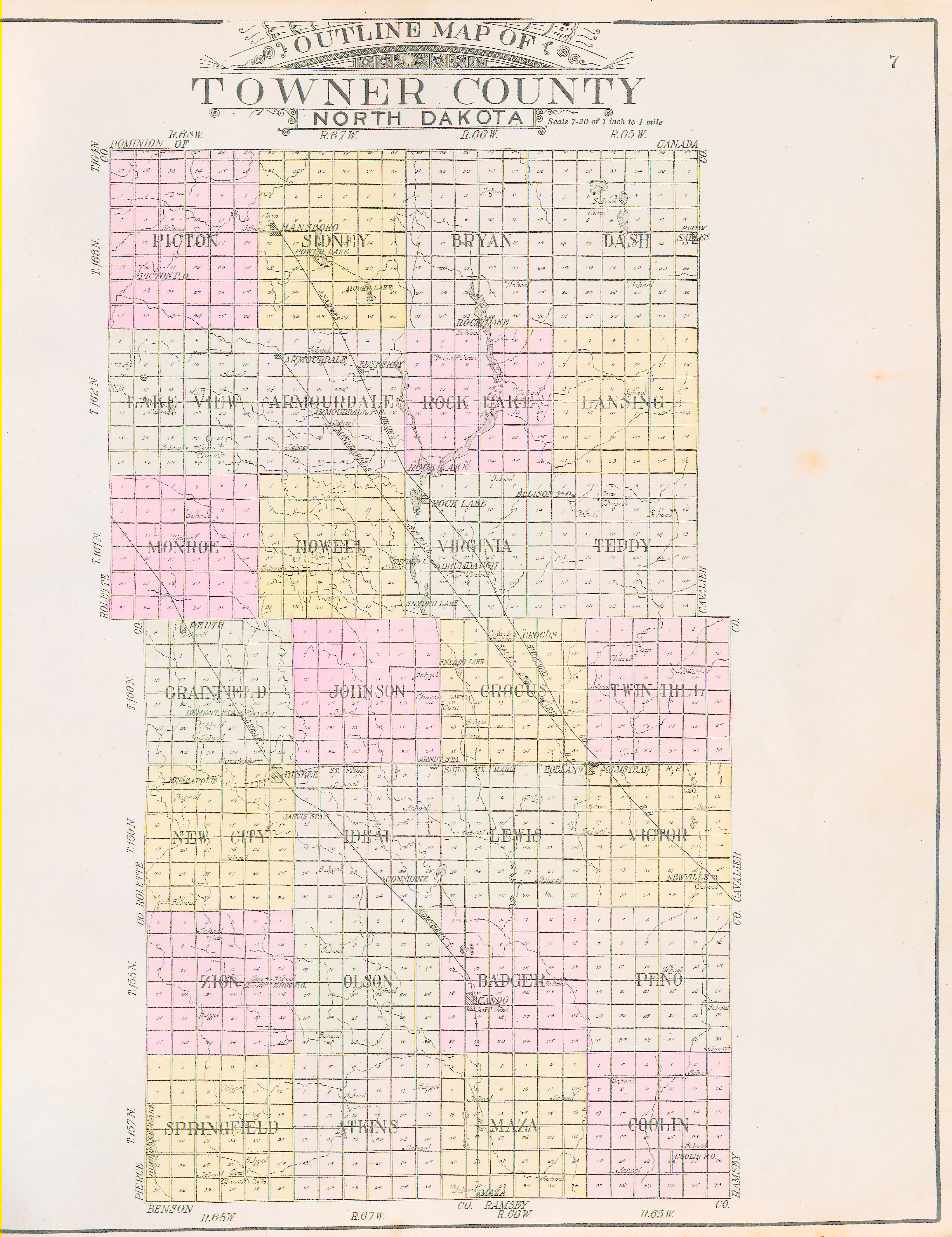
Towner County is a county in the U.S. state of North Dakota. As of the 2020 census, the population is 2,162. Its county seat is Cando. It is south of the Canada–US border with Manitoba. History The Dakota Territory legislature created the county on March 8, 1883, with areas partitioned from Cavalier and Rolette counties. It was named for Oscar M. Towner (1842–1897), a businessman and member of the 15th territorial legislature. The county organization was not completed at that time, and the county was attached to Pembina County for judicial and administrative purposes. That lasted until January 24, 1884, when the county organization was effected, and its attachment to Pembina was dissolved. However, on January 26, 1889, the county was attached to Ramsey County for judicial and administrative purposes. This arrangement only lasted a few months. The boundaries of Towner County as first formed have not been altered to the present (as of 2019). The ''city'' of Towner, Nort ... [...More Info...] [...Related Items...] OR: [Wikipedia] [Google] [Baidu] |
Municipality Of Boissevain – Morton
The Municipality of Boissevain – Morton is a rural municipality (RM) in the Westman Region of the Canadian province of Manitoba. History The RM was incorporated on January 1, 2015 via the amalgamation of the RM of Morton and the Town of Boissevain. It was formed as a requirement of ''The Municipal Amalgamations Act'', which required that municipalities with a population less than 1,000 amalgamate with one or more neighbouring municipalities by 2015. The Government of Manitoba initiated these amalgamations in order for municipalities to meet the 1997 minimum population requirement of 1,000 to incorporate a municipality. Demographics In the 2021 Census of Population conducted by Statistics Canada, Boissevain-Morton had a population of 2,309 living in 982 of its 1,141 total private dwellings, a change of from its 2016 population of 2,353. With a land area of , it had a population density of in 2021. Attractions The International Peace Garden is located on the southern b ... [...More Info...] [...Related Items...] OR: [Wikipedia] [Google] [Baidu] |
United States
The United States of America (U.S.A. or USA), commonly known as the United States (U.S. or US) or America, is a country primarily located in North America. It consists of 50 states, a federal district, five major unincorporated territories, nine Minor Outlying Islands, and 326 Indian reservations. The United States is also in free association with three Pacific Island sovereign states: the Federated States of Micronesia, the Marshall Islands, and the Republic of Palau. It is the world's third-largest country by both land and total area. It shares land borders with Canada to its north and with Mexico to its south and has maritime borders with the Bahamas, Cuba, Russia, and other nations. With a population of over 333 million, it is the most populous country in the Americas and the third most populous in the world. The national capital of the United States is Washington, D.C. and its most populous city and principal financial center is New York City. Paleo-Americ ... [...More Info...] [...Related Items...] OR: [Wikipedia] [Google] [Baidu] |
Cartwright – Roblin Municipality
Cartwright–Roblin Municipality is a rural municipality in the Canadian province of Manitoba. History The municipality was created on January 1, 2015 via the amalgamation of the RM of Roblin (2011 population 932) and the Village of Cartwright (2011 population 308). It was formed as a requirement of ''The Municipal Amalgamations Act'', which required that municipalities with a population less than 1,000 amalgamate with one or more neighbouring municipalities by 2015. The Government of Manitoba initiated these amalgamations in order for municipalities to meet the 1997 minimum population requirement of 1,000 to incorporate a municipality. The former Rural Municipality of Roblin in the Canadian province of Manitoba was originally incorporated as a rural municipality on November 15, 1902. It ceased on January 1, 2015 as a result of its provincially mandated amalgamation with the Village of Cartwright to form Cartwright – Roblin Municipality. Geography According to Statisti ... [...More Info...] [...Related Items...] OR: [Wikipedia] [Google] [Baidu] |
Rural Municipality Of Prairie Lakes
The Rural Municipality of Prairie Lakes is a rural municipality (RM) in the Canadian province of Manitoba. The Rural Municipality of Prairies lakes surrounds most of the north end of Pelican Lake. There are several other lakes in the RM such as Grass Lake, Overend Lake, Bone Lake, Lorne Lake, Louise Lake, Lloyds Lake, Noble Lake and many more that are all much smaller than Pelican Lake. History Rural Municipality of Riverside was originally incorporated as a rural municipality on December 22, 1883. Rural Municipality of Strathcona was originally incorporated as a rural municipality in April 1906. The Rural Municipality of Prairie Lakes was created on January 1, 2015 via the amalgamation of the RMs of Strathcona and Riverside. It was formed as a requirement of ''The Municipal Amalgamations Act'', which required that municipalities with a population less than 1,000 amalgamate with one or more neighbouring municipalities by 2015. The Government of Manitoba initiated these ama ... [...More Info...] [...Related Items...] OR: [Wikipedia] [Google] [Baidu] |
2021 Canadian Census
The 2021 Canadian census was a detailed enumeration of the Canadian population with a reference date of May 11, 2021. It follows the 2016 Canadian census, which recorded a population of 35,151,728. The overall response rate was 98%, which is slightly lower than the response rate for the 2016 census. It recorded a population of 36,991,981, a 5.2% increase from 2016. Planning Consultation on census program content was from September 11 to December 8, 2017. The census was conducted by Statistics Canada, and was contactless as a result of the COVID-19 pandemic in Canada. The agency had considered delaying the census until 2022. About 900 supervisors and 31,000 field enumerators were hired to conduct the door-to-door survey of individuals and households who had not completed the census questionnaire by late May or early June. Canvassing agents wore masks and maintained a physical distance to comply with COVID-19 safety regulations. Questionnaire In early May 2021, Statistics Can ... [...More Info...] [...Related Items...] OR: [Wikipedia] [Google] [Baidu] |
Lena, Manitoba
Lena is an unincorporated community located in the Municipality of Killarney-Turtle Mountain in south central Manitoba, Canada. It is located approximately 89 kilometers (55 miles) southeast of Brandon, Manitoba, at the junction of Manitoba Highway 18 Provincial Trunk Highway 18 (PTH 18) is a provincial highway in the Canadian province of Manitoba. It is a north-south route; the southern terminus is the St. John–Lena Border Crossing at the Canada–United States border and the northern term ... and Provincial Road 341. References See also * St. John–Lena Border Crossing Unincorporated communities in Westman Region Municipality of Killarney-Turtle Mountain {{Manitoba-geo-stub ... [...More Info...] [...Related Items...] OR: [Wikipedia] [Google] [Baidu] |
Killarney, Manitoba
Killarney is an unincorporated community in southwestern Manitoba, Canada, at the corner of List of Manitoba provincial highways, Manitoba Provincial Trunk Highways Manitoba Highway 3, 3 & Manitoba Highway 18, 18. The community was formerly an incorporated town before amalgamating with the surrounding Rural Municipality of Turtle Mountain to form the Municipality of Killarney-Turtle Mountain. Killarney is known for the lake situated within the community. Killarney is located in a rural area, dependent primarily on agriculture and agribusiness. It is approximately from the Canada–United States border, Canada-US border, south of Brandon, Manitoba, Brandon and southwest of the provincial capital, Winnipeg. History The Municipality of Killarney-Turtle Mountain area is rich in history and tradition. In the late 1800s, the Boundary Commission Trail ran through the southern part of the municipality. North-West Mounted Police used the trail, as they travelled west to the Rocky M ... [...More Info...] [...Related Items...] OR: [Wikipedia] [Google] [Baidu] |
Rural Municipality Of Turtle Mountain
Turtle Mountain or Turtle Mountains may refer to: * Turtle Mountain in Alberta, Canada * Turtle Mountain in Shanxi, China * Turtle Mountain (electoral district), a provincial electoral division in the Canadian province of Manitoba * Turtle Mountain (plateau), a mountainous area in the Canadian province of Manitoba and the U.S. state of North Dakota * Turtle Mountain Band of Chippewa Indians, a Native American tribe of Ojibwa and Métis peoples * Turtle Mountain Community College, a tribal college in Belcourt, North Dakota * Turtle Mountain Indian Reservation, an Indian Reservation located primarily in northern North Dakota * Turtle Mountain Provincial Park, a provincial park located in the southwestern portion of the Canadian province of Manitoba * Turtle Mountains (California) The Turtle Mountains (Amat 'Achii'ar in the Mojave language), are located in northeastern San Bernardino County, California, San Bernardino County, in the southeastern part of California. The colorful Tu ... [...More Info...] [...Related Items...] OR: [Wikipedia] [Google] [Baidu] |
North Dakota
North Dakota () is a U.S. state in the Upper Midwest, named after the Native Americans in the United States, indigenous Dakota people, Dakota Sioux. North Dakota is bordered by the Canadian provinces of Saskatchewan and Manitoba to the north and by the U.S. states of Minnesota to the east, South Dakota to the south, and Montana to the west. It is believed to host the geographic center of North America, Rugby, North Dakota, Rugby, and is home to the tallest man-made structure in the Western Hemisphere, the KVLY-TV mast. North Dakota is the List of U.S. states and territories by area, 19th largest state, but with a population of less than 780,000 2020 United States census, as of 2020, it is the List of U.S. states and territories by population, 4th least populous and List of U.S. states by population density, 4th most sparsely populated. The capital is Bismarck, North Dakota, Bismarck while the largest city is Fargo, North Dakota, Fargo, which accounts for nearly a fifth of the s ... [...More Info...] [...Related Items...] OR: [Wikipedia] [Google] [Baidu] |


