|
Mundari Language
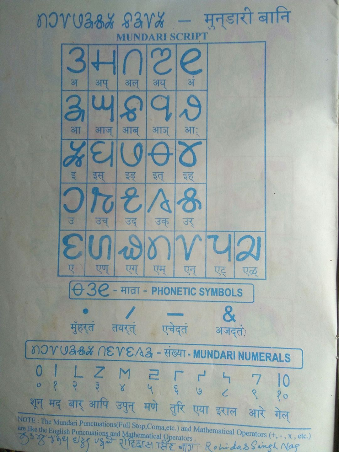
Mundari (Munɖari) is a Munda language of the Austroasiatic language family spoken by the Munda tribes in eastern Indian states of Jharkhand, Odisha and West Bengal. It is closely related to Santali. Mundari Bani, a script specifically to write Mundari, was invented by Rohidas Singh Nag. It has also been written in the Devanagari, Odia, Bengali, and Latin writing systems. History According to linguist Paul Sidwell (2018), Munda languages probably arrived on coast of Odisha from Indochina about 4000–3500 years ago and spread after Indo-Aryan migration to Odisha. Geographical distribution Mundari is spoken in the Ranchi, Khunti, Seraikela Kharsawan and West Singhbhum, East Singhbhum district of Jharkhand, and in the Mayurbhanj, Kendujhar, Baleshwar, Sundargarh district of Odisha by at least 1.1 million people. Another 500,000, mainly in Odisha and Assam, are recorded in the census as speaking "Munda," potentially another name for Mundari. Dialects Toshiki Osada (2008: ... [...More Info...] [...Related Items...] OR: [Wikipedia] [Google] [Baidu] |
India
India, officially the Republic of India (Hindi: ), is a country in South Asia. It is the seventh-largest country by area, the second-most populous country, and the most populous democracy in the world. Bounded by the Indian Ocean on the south, the Arabian Sea on the southwest, and the Bay of Bengal on the southeast, it shares land borders with Pakistan to the west; China, Nepal, and Bhutan to the north; and Bangladesh and Myanmar to the east. In the Indian Ocean, India is in the vicinity of Sri Lanka and the Maldives; its Andaman and Nicobar Islands share a maritime border with Thailand, Myanmar, and Indonesia. Modern humans arrived on the Indian subcontinent from Africa no later than 55,000 years ago., "Y-Chromosome and Mt-DNA data support the colonization of South Asia by modern humans originating in Africa. ... Coalescence dates for most non-European populations average to between 73–55 ka.", "Modern human beings—''Homo sapiens''—originated in Africa. Then, int ... [...More Info...] [...Related Items...] OR: [Wikipedia] [Google] [Baidu] |
Santali Language
Santali (, Ol Chiki: ), Bengali: , Odia: , Devanagari: , also known as Santal, is the most widely spoken language of the Munda subfamily of the Austroasiatic languages, related to Ho and Mundari, spoken mainly in the Indian states of Assam, Bihar, Jharkhand, Mizoram, Odisha, Tripura and West Bengal. It is a recognised regional language of India per the Eighth Schedule of the Indian Constitution. It is spoken by around 7.0 million people in India, Bangladesh, Bhutan and Nepal, making it the third most-spoken Austroasiatic language after Vietnamese and Khmer. Santali was a mainly oral language until the development of Ol Chiki by Pandit Raghunath Murmu in 1925. Ol Chiki is alphabetic, sharing none of the syllabic properties of the other Indic scripts, and is now widely used to write Santali in India. History According to linguist Paul Sidwell, Munda languages probably arrived on the coast of Odisha from Indochina about 4000–3500 years ago,and spread after the Indo-Aryan ... [...More Info...] [...Related Items...] OR: [Wikipedia] [Google] [Baidu] |
Kendujhar District
Kendujhar District, is an administrative district of Odisha. The district is one of the fifth Scheduled Areas of Odisha. The town of Kendujhar (or Kendujhargarh) is the district headquarters. The district has 3 Sub-Divisions, Anandapur, Champua, and Kendujhar. Etymology Origin of the name Keonjhar/Kendujhar is not certain. In the locals pronounce the name as ''Kenjhar''. In medieval Sanskrit inscriptions the name is "Kenjhar" is found. The name has been Sanskritised to Kendujhar by the ex-Durbar government. The name ''Kendujhar'' is derived from ''"Kendu"'' meaning East Indian Ebony (tree which is abundant in the district) and ''"Jhar"'' meaning water spring. History Early history of Kendujhar is not certain. Nagas of Vindhyatabi ruled keonjhar during the 2nd century CE to 4th century CE and Satrubhanja was famous king of the dynasty. In Sitabhinji, fresco paintings were found in the cave shelter of Ravana Chhaya, which date to the 5th century A.D. Written reference ... [...More Info...] [...Related Items...] OR: [Wikipedia] [Google] [Baidu] |
Mayurbhanj District
Mayurbhanj district is one of the 30 districts in Odisha state in eastern India. It is the largest district of Odisha by area. Its headquarters are at Baripada. Other major towns are Rairangpur, Karanjia and Udala. , it is the third-most-populous district of Odisha (out of 30), after Ganjam and Cuttack. Etymology The name of the district is a portmanteau of '' Mayura'' (meaning peacock in Odia) and '' Bhanja'', the name of the two ruling dynasty of the district till 1949. It is believed that the Mayura was the name of another dynasty that merged with the Bhanjas sometime around the 14th century. The peacock motif was later adopted by the Bhanjas and featured on the Mayurbhanj coat of arms. The Mayurbhanj alternative spellings were noted as ''Mohurbunge'' and ''Morbhanj'' in many British India records. History The Bhanja family who ruled Mayurbhanj State are closely associated with the district's history. They probably displaced an earlier ruling family with the same name w ... [...More Info...] [...Related Items...] OR: [Wikipedia] [Google] [Baidu] |
East Singhbhum District
East Singhbhum is one of the 24 districts of Jharkhand, India. It was created on 16 January 1990. More than 50% of the district is covered by dense forests and mountains, where wild animals once roamed freely. It is known for being a centre of industry since Jamshedpur, the most populous city in Jharkhand, is located here. Geography The district is bounded on the east by Jhargram district, on the north by Purulia district, both of West Bengal, on the west by Seraikela Kharsawan district, and on the south by Mayurbhanj district of Odisha. Total area of the district is 3,562 kilometers. The district is a mineral rich and industrialized region. Dalma Wildlife Sanctuary is a popular biosphere reserve known lively for its animals. Dalma Hills is stretching over Jharkhand and West Bengal. It is on the northern region of Jamshedpur. A lot of minerals are found here. Politics Administration There are six Vidhan Sabha constituencies in this district: Baharagora, Ghatsila, Potka, Ju ... [...More Info...] [...Related Items...] OR: [Wikipedia] [Google] [Baidu] |
West Singhbhum District
West Singhbhum or Pashchimi Singhbhum is one of the 24 districts of Jharkhand state, India. It came into existence on 16 January 1990, when the old Singhbhum district (then in Bihar) was bifurcated. Chaibasa is the district headquarters. The district is bounded on north by Khunti district, on the east by Seraikela Kharsawan district, Saraikela Kharsawan district of Jharkhand, on the southeast by Mayurbhanj district of Odisha, on the south by Kendujhar district of Odisha, and on the west by Simdega district of Jharkhand and Sundergarh district of Odisha. History Several Slag, Iron slags, microlith, Potsherds have been discovered from Singhbhum district which are from 1400 BCE according to Carbon dating age. West Singhbhum is one of the oldest districts of Jharkhand. After the British conquest of Kolhan in 1837, a new district was consequently constituted to be known as Singhbhum with Chaibasa as its headquarters. Subsequently, three districts, namely East Singhbhum, West Singhb ... [...More Info...] [...Related Items...] OR: [Wikipedia] [Google] [Baidu] |
Khunti District
Khunti district is one of the twenty-four districts in South Chotanagpur division of the Indian state of Jharkhand. The district of Khunti was carved out of Ranchi district on 12 September 2007. , it is the second least populous district of Jharkhand (out of 24), after Lohardaga. Khunti town is the headquarters of the district. It is historically known as the birthplace of Birsa Munda, and being the centre of activity of the Birsa movement.Birsa Mumda commemorative postage stamp and biography , 15 November 1988''. The district is currently a part of the |
Ranchi District
Ranchi district is the most populous district of Jharkhand state in eastern India. Ranchi, the capital of Jharkhand, is the district headquarters. It was established as a district in 1899. History Iron slag, potsherds and iron tools have been found in the Chota Nagpur plateau dated to 1400 BCE. Magadha Empire exercised indirect control over the territory, which lasted until the reign of the Ashoka. Kalinga rulers are believed to have ravaged the region during their expeditions to Rajgir and Pataliputra. Armies of Samudra Gupta passed through the region on their expedition to Deccan. After the decline of the Guptas, Phani Mukut Rai established the Nagvanshi dynasty c. 1000 CE, which ruled Ranchi district and part of Chota Nagpur Plateau as a sovereign king for almost next 1000 years. Khukhragarh was one of the capitals of Nagvanshi dynasty. With the expansion of the Mughal Empire, the Nagvanshis were forced to pay tribute, but they continued to rule and administer independe ... [...More Info...] [...Related Items...] OR: [Wikipedia] [Google] [Baidu] |
Mainland Southeast Asia
Mainland Southeast Asia, also known as the Indochinese Peninsula or Indochina, is the continental portion of Southeast Asia. It lies east of the Indian subcontinent and south of Mainland China and is bordered by the Indian Ocean to the west and the Pacific Ocean to the east. It includes the countries of Cambodia, Laos, Myanmar, Thailand and Vietnam, with peninsular Malaysia sometimes also being included. The term Indochina (originally Indo-China) was coined in the early nineteenth century, emphasizing the historical cultural influence of Indian and Chinese civilizations on the area. The term was later adopted as the name of the colony of French Indochina (today's Cambodia, Laos, and Vietnam). Today, the term, Mainland Southeast Asia, in contrast to Maritime Southeast Asia, is more commonly referenced. Terminology The origins of the name Indo-China are usually attributed jointly to the Danish-French geographer Conrad Malte-Brun, who referred to the area as in 1804, and the ... [...More Info...] [...Related Items...] OR: [Wikipedia] [Google] [Baidu] |
Paul Sidwell
Paul James Sidwell is an Australian linguist based in Canberra, Australia who has held research and lecturing positions at the Australian National University. Sidwell, who is also an expert and consultant in forensic linguistics, is most notable for his work on the historical linguistics of the Austroasiatic languages, Austroasiatic language family, and has published reconstructions of the Bahnaric languages, Bahnaric, Katuic languages, Katuic, Palaungic languages, Palaungic, Khasian languages, Khasic, and Nicobarese languages, Nicobaric proto-languages. Sidwell is currently the President of the Southeast Asian Linguistics Society. Career In 2001, Sidwell was appointed as a Collaborating Scientist at the Max Planck Institute for Evolutionary Anthropology, Leipzig. From 2001 to 2004, he was an Australian Research Council Postdoctoral Research Fellow at the Australian National University, remaining there from 2005 to 2007 as a Visiting Research Fellow, funded by the Max Planck Inst ... [...More Info...] [...Related Items...] OR: [Wikipedia] [Google] [Baidu] |


