|
Mulranny
Mulranny ()—sometimes spelled as 'Mallaranny', 'Mulrany', 'Malaranny', 'Mullaranny', 'Mullranny' or 'Mulranny'—is a seaside village on the isthmus between Clew Bay and Blacksod Bay in County Mayo, Ireland. Mulranny, located at the foot of the Nephin Mountain Range, has a number of blue flag beaches and a coastal lagoon. The Corraun Peninsula, which contains three mountain peaks, is situated across Clew Bay. Transport Mulranny is located on the N59 national secondary road. Bus routes serving the area include Bus Éireann route 450 (Dooagh- Westport-Louisburgh) and Local Link route 978 (Castlebar-Belmullet). Tourism Mulranny lies on the 42 km Great Western Greenway, which runs between Westport and Achill. In 2011, it was the winner of a 'European Destinations of Excellence' award. A type of heather, ''Erica erigena'', which is unique to the area, is celebrated during the annual summer "Mulranny Mediterranean Heather Festival". Notable people * Colm McManamon, G ... [...More Info...] [...Related Items...] OR: [Wikipedia] [Google] [Baidu] |
Great Western Greenway
The Great Western Greenway () is a greenway rail trail in County Mayo, Ireland. It is long and begins in Westport and ends in Achill, passing through the towns of Newport and Mulranny as it runs along the coast of Clew Bay. It is an off-road trail intended for use by cyclists and walkers. It follows the route of the former Achill extension of the Westport railway line, which was constructed in the 1890s and closed in 1937. An estimated 300 people cycle and walk the trail each day, which was constructed at a cost of €5.7 million. The first section, from Newport to Mulranny, was opened in April 2010. It was named as the 2011 Irish winner of the European Destinations of Excellence award. The full route was opened by Taoiseach Enda Kenny, T. D. and Minister of State for Tourism and Sport, Michael Ring, T. D., on 29 July 2011. According to a 2013 study, the Great Western Greenway had an average of 471 cycle trips per day, or 172,000 users in total per annum. It brings approx ... [...More Info...] [...Related Items...] OR: [Wikipedia] [Google] [Baidu] |
Clew Bay
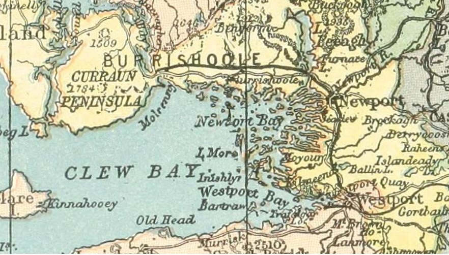
Clew Bay (; ga, Cuan Mó) is a natural ocean bay in County Mayo, Republic of Ireland. It contains Ireland's best example of sunken drumlins. The bay is overlooked by Croagh Patrick to the south and the Nephin Range mountains of North Mayo. Clare Island guards the entrance of the bay. From the southwest part of the bay eastwards are Louisburgh, Lecanvey, Murrisk, and Westport; north of Westport is Newport, and westwards from there lies Mulranny, gateway to Achill. From the south side of the bay, between Clare Island and Achill, Bills Rocks can be seen. History The bay was anciently known in Irish as ''Cuan Mod'' 'h''("Mod Harbour") or ''Modlind'' ("Mod Pool"), and was associated with the Fir Bolg. Some writers claim that this name derives from Modh, one of the Tuatha Dé Danann. Another possibility is the Old Irish ''mod'', ''moth'', which meant "penis"; it is possible that the bay was imagined as a penis thrusting into the land. Another old name is ''Cuan Umaill'' ("h ... [...More Info...] [...Related Items...] OR: [Wikipedia] [Google] [Baidu] |
Westport, County Mayo
Westport (, historically anglicised as ''Cahernamart'') is a town in County Mayo in Ireland.Westport Before 1800 by Michael Kelly published in Cathair Na Mart 2019 It is at the south-east corner of Clew Bay, an inlet of the Atlantic Ocean on the west coast of Ireland. Westport is a tourist destination and scores highly for quality of life. It won the Irish Tidy Towns Competition three times in 2001, 2006 and 2008. In 2012 it won the Best Place to Live in Ireland competition run by ''The Irish Times''. Westport is designated as a heritage town, and is one of only a few planned towns in Ireland. The town centre was laid-out in the Georgian architectural style, and incorporates the Carrow Beg river into the design composition. This provides for tree lined promenades (known as The Mall) and several stone bridges. The pilgrimage mountain of Croagh Patrick, known locally as "the Reek", lies some 10 km west of the town near the villages of Murrisk and Lecanvey. The mountain form ... [...More Info...] [...Related Items...] OR: [Wikipedia] [Google] [Baidu] |
County Mayo
County Mayo (; ga, Contae Mhaigh Eo, meaning "Plain of the Taxus baccata, yew trees") is a Counties of Ireland, county in Republic of Ireland, Ireland. In the West Region, Ireland, West of Ireland, in the Provinces of Ireland, province of Connacht, it is named after the village of Mayo, County Mayo, Mayo, now generally known as Mayo Abbey. Mayo County Council is the Local government in the Republic of Ireland, local authority. The population was 137,231 at the 2022 census of Ireland, 2022 census. The boundaries of the county, which was formed in 1585, reflect the Mac William Íochtar lordship at that time. Geography It is bounded on the north and west by the Atlantic Ocean; on the south by County Galway; on the east by County Roscommon; and on the northeast by County Sligo. Mayo is the third-largest of Ireland's 32 counties in area and 18th largest in terms of population. It is the second-largest of Connacht's five counties in both size and population. Mayo has of coastline, ... [...More Info...] [...Related Items...] OR: [Wikipedia] [Google] [Baidu] |
Colm McManamon
Colm McManamon (Cólm Mac Meanman) is a former Gaelic footballer from Tiernaur, Mulranny, County Mayo, Ireland who played for Burrishoole and the Mayo county team. He represented Ireland twice in International Rules. He is related to Dublin footballer Kevin McManamon. See also * 1996 All-Ireland Senior Football Championship Final * Geelong Football Club * Irish experiment The Irish Experiment is the popular name for the interest, primarily from VFL/AFL clubs, in bringing Irish sportspeople, particularly Gaelic footballers, to Australia to play Australian rules football professionally. The AFL's focus on Gaeli ... References Burrishoole Gaelic footballers Irish international rules football players Mayo inter-county Gaelic footballers {{1989 VFL national draft ... [...More Info...] [...Related Items...] OR: [Wikipedia] [Google] [Baidu] |
N59 Road (Ireland)
The N59 road is a national secondary road in Ireland. It commences in County Sligo, south of Sligo Town at the Belladrehid interchange with the N4 north of Ballysadare. The route circles around the west of Ireland, passing west from Sligo into County Mayo and through Ballina. The N59 continues around Mayo, proceeding indirectly to Westport. Continuing south through Mayo into County Galway, the road passes through the village of Leenaun. The 182-year-old bridge in the centre of the village, carrying the road across the River Lahill, collapsed in floods on 18 July 2007. Due to the local terrain and road network, the diversionary route for getting from the south of the village to Westport was 110 km long. A temporary bridge was opened eight days after the floods, on 27 July. It has since been replaced by a new bridge. South of Leenaun, the N59 proceeds southwest through Connemara to Clifden. From there, it returns east through Maam Cross and to Oughterard, from which it ... [...More Info...] [...Related Items...] OR: [Wikipedia] [Google] [Baidu] |
Republic Of Ireland
Ireland ( ga, Éire ), also known as the Republic of Ireland (), is a country in north-western Europe consisting of 26 of the 32 counties of the island of Ireland. The capital and largest city is Dublin, on the eastern side of the island. Around 2.1 million of the country's population of 5.13 million people resides in the Greater Dublin Area. The sovereign state shares its only land border with Northern Ireland, which is part of the United Kingdom. It is otherwise surrounded by the Atlantic Ocean, with the Celtic Sea to the south, St George's Channel to the south-east, and the Irish Sea to the east. It is a unitary, parliamentary republic. The legislature, the , consists of a lower house, ; an upper house, ; and an elected President () who serves as the largely ceremonial head of state, but with some important powers and duties. The head of government is the (Prime Minister, literally 'Chief', a title not used in English), who is elected by the Dáil and appointed by ... [...More Info...] [...Related Items...] OR: [Wikipedia] [Google] [Baidu] |
Castlebar
Castlebar () is the county town of County Mayo, Republic of Ireland, Ireland. Developing around a 13th century castle of the de Barry family, de Barry family, from which the town got its name, the town now acts as a social and economic focal point for the surrounding hinterland. With a population of 12,318 in the 2011 census of Ireland, 2011 census (up from 3,698 in the 1911 census of Ireland, 1911 census), Castlebar was one of the fastest growing town in Ireland in the early 21st century. A campus of Atlantic Technological University and the National Museum of Ireland – Country Life, Country Life section of the National Museum are two important facilities in the area. The town is rail transport in Ireland, linked by railway to Dublin, Westport, County Mayo, Westport and Ballina, County Mayo, Ballina. The main route by road is the N5 road (Ireland), N5. History The modern town grew up as a settlement around the de Barry family, de Barry castle, which was built by a Norman ... [...More Info...] [...Related Items...] OR: [Wikipedia] [Google] [Baidu] |
Dooagh
Dooagh ( ga, Dumha Acha) is a village located on Achill Island in County Mayo, Ireland. It is best known for the nearby Keem Bay, a Blue Flag beach. Dooagh beach Between May 2017 and January 2019, Dooagh beach had of golden sand. Previously, the sand was completely washed away in a storm in 1984, leaving a rocky foreshore that remained until the sand was restored by an unusually high tide in April 2017. The new sandy beach was reported as causing an increase in tourism to the village. Dooagh beach washed away for a second time in early 2019. Transport Road Dooagh is located on the R319 regional road. Bus Éireann route 440 (Dooagh– Westport–Ireland West Airport Knock) operates once a day on weekdays in each direction. ''Expressway'' route 52 provides an evening journey each way to/from Westport and Galway. Rail The nearest rail services are at Westport railway station, away. There are several trains a day from Westport to Dublin Heuston via Athlone. Facilities Doo ... [...More Info...] [...Related Items...] OR: [Wikipedia] [Google] [Baidu] |
Louisburgh
Louisburgh () is a small town on the southwest corner of Clew Bay in County Mayo, Ireland. It is home to Sancta Maria College and the Gráinne O'Malley Interpretive Centre. Transport Road access Louisburgh is located on the R335 regional road. It can be approached from Westport (13 miles) or from Leenane (19 miles). The former approach passes along Clew Bay on one side and Croagh Patrick on the other, while the latter passes through lake and mountain scenery past Doo Lough and Delphi Lodge. Bus services Bus Éireann local route 450 (Louisburgh-Lecanvey-Westport-Achill) provides several daily journeys in each direction. The company's Thursday-only route to Killeen and Killadoon was discontinued in November 2020. Rail access The nearest rail services are from Westport railway station, approximately 24 km distant. There are several trains a day from Westport to Dublin Heuston via Athlone. History Most of Louisburgh lies within the townland of Clooncarrabaun (an an ... [...More Info...] [...Related Items...] OR: [Wikipedia] [Google] [Baidu] |
European Destinations Of Excellence
European Destinations of ExcelleNce, also known by the acronym EDEN, is an initiative launched by the European Commission promoting sustainable tourism development models across Europe. The project is based on national competitions which take place every year since 2006 and results in the selection of a “destination of excellence” for each participating country. The winners are emerging, lesser known destinations located in the 27 EU Member States, the Candidate Countries and the EFTA/ EEA countries. The objectives of EDEN Tourism is a strategic economic activity in the European Union, whose importance is likely to continue to increase in the coming years. It has a great potential as regards contributing to the achievement of several major EU objectives, such as sustainable development, economic growth, employment as well as economic and social cohesion. For achieving these goals the European Commission has launched the EDEN project. Selection process of the EDEN destinati ... [...More Info...] [...Related Items...] OR: [Wikipedia] [Google] [Baidu] |
Belmullet
Belmullet (, IPA:[ˌbʲeːlənˠˈwʊɾˠhəd̪ˠ]) is a coastal Gaeltacht town with a population of 1,019 on the Mullet Peninsula in the barony (Ireland), barony of Erris, County Mayo, Republic of Ireland, Ireland. It is the commercial and cultural heart of the barony of Erris, which has a population of almost 10,000. According to the 2016 census 50% of people in the town were able to speak Irish while only 4% spoke it on a daily basis outside the education system. Belmullet has two bays, Blacksod Bay and Broadhaven Bay, linked by Carter's Canal running through the town. History The origin of the name ''Belmullet'' is not clear. It may have come from Irish ''Béal Muileat'' or ''Béal an Mhuileat'', which has been translated as "mouth of the isthmus". Bernard O'Hara in ''Mayo: Aspects of its Heritage'' suggests that "A change from 'L' to 'R', which is quite common in Irish, may have given ''Béal an Mhuireat'' which in turn became ''Béal an Mhuirhead''". It has also been sugg ... [...More Info...] [...Related Items...] OR: [Wikipedia] [Google] [Baidu] |


