|
Muar River (Mozambique)
Muar River (Rio Muar) is a stream in Sofala province of Mozambique Mozambique (), officially the Republic of Mozambique ( pt, Moçambique or , ; ny, Mozambiki; sw, Msumbiji; ts, Muzambhiki), is a country located in southeastern Africa bordered by the Indian Ocean to the east, Tanzania to the north, Malawi .... See also * List of rivers of Mozambique References Rivers of Mozambique {{Mozambique-river-stub ... [...More Info...] [...Related Items...] OR: [Wikipedia] [Google] [Baidu] |
Mozambique
Mozambique (), officially the Republic of Mozambique ( pt, Moçambique or , ; ny, Mozambiki; sw, Msumbiji; ts, Muzambhiki), is a country located in southeastern Africa bordered by the Indian Ocean to the east, Tanzania to the north, Malawi and Zambia to the northwest, Zimbabwe to the west, and Eswatini and South Africa to the southwest. The sovereign state is separated from the Comoros, Mayotte and Madagascar by the Mozambique Channel to the east. The capital and largest city is Maputo. Notably Northern Mozambique lies within the monsoon trade winds of the Indian Ocean and is frequentely affected by disruptive weather. Between the 7th and 11th centuries, a series of Swahili port towns developed on that area, which contributed to the development of a distinct Swahili culture and language. In the late medieval period, these towns were frequented by traders from Somalia, Ethiopia, Egypt, Arabia, Persia, and India. The voyage of Vasco da Gama in 1498 marked the arrival of t ... [...More Info...] [...Related Items...] OR: [Wikipedia] [Google] [Baidu] |
Sofala Province
Sofala is a province of Mozambique. It has a population of 2,259,248 (2017 census). Beira is the capital of the province, named for the ruined port of Sofala which is to the south. History Portuguese landholder and imperialist Joaquim Carlos Paiva de Andrada established a base at the river mouth at what is now Beira in 1884. Sofala Province is one of the strongholds of the RENAMO. In late 1978 RENAMO guerrillas were "ranging into Sofala Province and launching attacks along the Beira–Chimoio road and rail line, the Dondo–Inhaminga corridor". Some of the more scarcely populated areas of the province are affected by landmines; defensive rings around villages were still common in some rural areas according to mid 1990s reports by Oxfam. In March 2019, the province was severely affected by Cyclone Idai, with its capital city of Beira being largely destroyed. The flooding resulting from this storm was widespread throughout the province and the rest of Central Mozambique. De ... [...More Info...] [...Related Items...] OR: [Wikipedia] [Google] [Baidu] |
Stream
A stream is a continuous body of water, body of surface water Current (stream), flowing within the stream bed, bed and bank (geography), banks of a channel (geography), channel. Depending on its location or certain characteristics, a stream may be referred to by a variety of local or regional names. Long large streams are usually called rivers, while smaller, less voluminous and more intermittent river, intermittent streams are known as streamlets, brooks or creeks. The flow of a stream is controlled by three inputs – surface runoff (from precipitation or meltwater), daylighting (streams), daylighted subterranean river, subterranean water, and surfaced groundwater (Spring (hydrology), spring water). The surface and subterranean water are highly variable between periods of rainfall. Groundwater, on the other hand, has a relatively constant input and is controlled more by long-term patterns of precipitation. The stream encompasses surface, subsurface and groundwater fluxes th ... [...More Info...] [...Related Items...] OR: [Wikipedia] [Google] [Baidu] |
GeoNames
GeoNames (or GeoNames.org) is a user editable geographical database available and accessible through various web services, under a Creative Commons attribution license. The project was founded in late 2005. The GeoNames dataset differs from, but includes data from, the US Government's similarly named GEOnet Names Server. Database and web services The GeoNames database contains over 25,000,000 geographical names corresponding to over 11,800,000 unique features. All features are categorized into one of nine feature classes and further subcategorized into one of 645 feature codes. Beyond names of places in various languages, data stored include latitude, longitude, elevation, population, administrative subdivision and postal codes. All coordinates use the World Geodetic System 1984 (WGS84). Those data are accessible free of charge through a number of Web services and a daily database export. Wiki interface The core of GeoNames database is provided by official public sources, ... [...More Info...] [...Related Items...] OR: [Wikipedia] [Google] [Baidu] |
List Of Rivers Of Mozambique
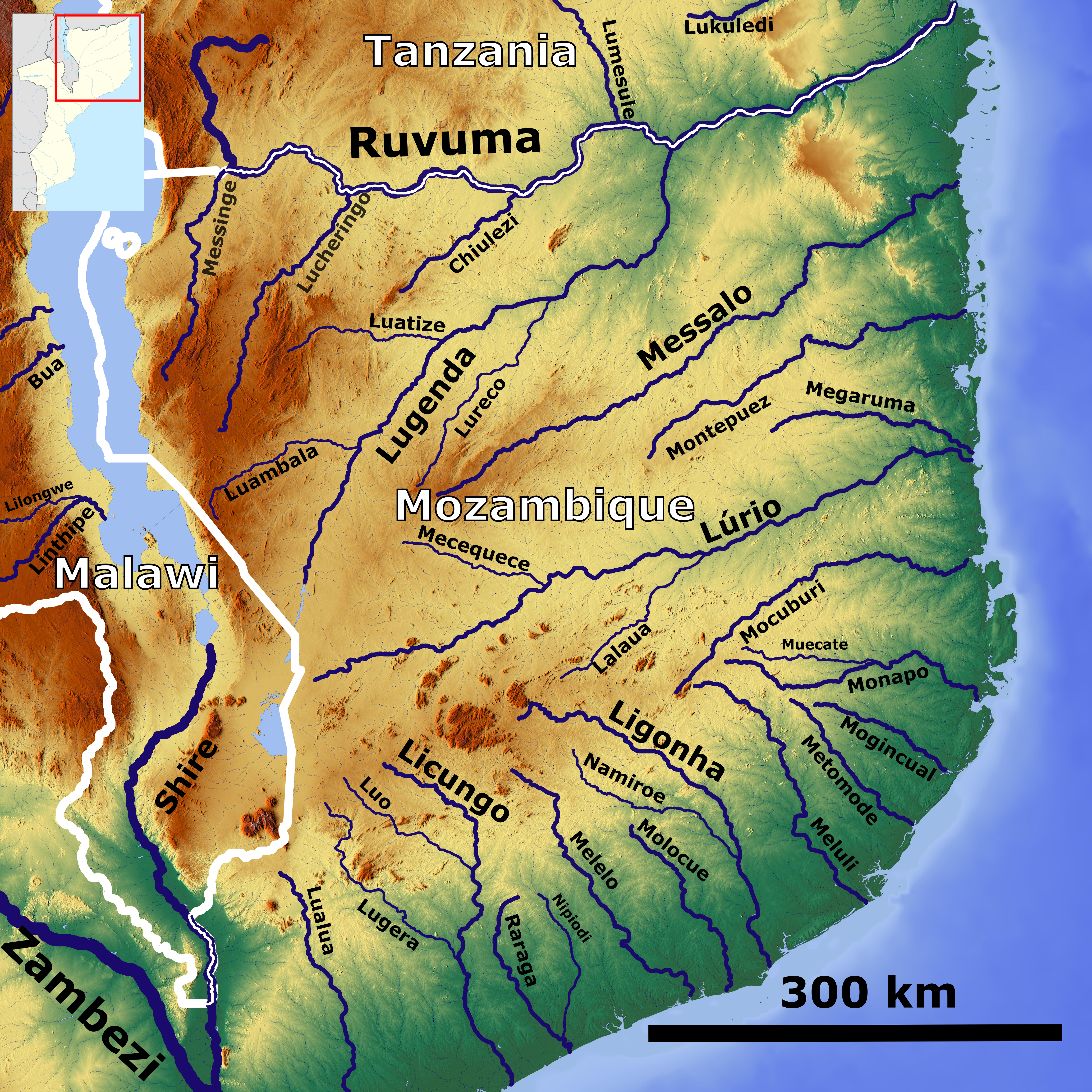
This is a list of rivers in Mozambique. This list is arranged by drainage basin, with respective tributaries indented under each larger stream's name. Indian Ocean * Ruvuma River **Lugenda River *** Lureco River *** Luatize River *** Lotchese River ***Luambala River *** Luchimua River *** Mandimbe River **** Ngalamu River ** Chiulezi River ** Luchulingo River ** Messinge River (Msinje River) * Messalo River * Montepuez River *Lúrio River * Mecuburi River * Sanhute River * Monapo River * Mugincual River * Melúli River * Ligonha River * Melela River * Raraga River *Licungo River * Cuácua River (Rio dos Bons Sinais) (Quelimane River) ** Licuare River ** Lualua River * Mucarau River * Zambezi River ** Chinde River (distributary) *** Inhaombe River ** Zangue River *** Nhamapasa River ** Shire River ***Lake Malawi **** Msinje River ** Pompué River **Luenha River *** Mazowe River **** Ruya River (Luia River) *** Gairezi River (Cauresi River) **Revúboé River ** Luia River *** Cheris ... [...More Info...] [...Related Items...] OR: [Wikipedia] [Google] [Baidu] |

_nahe_dem_Weiherdamm_in_Wildbergerhütte.jpg)

