|
Mountain Building
Mountain formation refers to the geological processes that underlie the formation of mountains. These processes are associated with large-scale movements of the Earth's crust (tectonic plates). Folding, faulting, volcanic activity, igneous intrusion and metamorphism can all be parts of the orogenic process of mountain building. The formation of mountains is not necessarily related to the geological structures found on it. The understanding of specific landscape features in terms of the underlying tectonic processes is called '' tectonic geomorphology'', and the study of geologically young or ongoing processes is called ''neotectonics''. From the late 18th century until its replacement by plate tectonics in the 1960s, geosyncline theory was used to explain much mountain-building. Types of mountains There are five main types of mountains: volcanic, fold, plateau, fault-block and dome. A more detailed classification useful on a local scale predates plate tectonics and adds to ... [...More Info...] [...Related Items...] OR: [Wikipedia] [Google] [Baidu] |
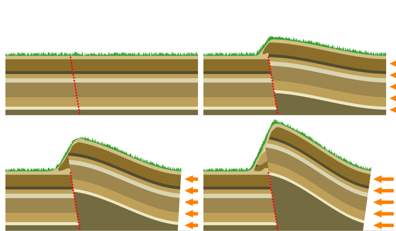
Mountain By Reverse Fault
A mountain is an elevated portion of the Earth's crust, generally with steep sides that show significant exposed bedrock. Although definitions vary, a mountain may differ from a plateau in having a limited summit area, and is usually higher than a hill, typically rising at least 300 metres (1,000 feet) above the surrounding land. A few mountains are isolated summits, but most occur in mountain ranges. Mountains are formed through tectonic forces, erosion, or volcanism, which act on time scales of up to tens of millions of years. Once mountain building ceases, mountains are slowly leveled through the action of weathering, through slumping and other forms of mass wasting, as well as through erosion by rivers and glaciers. High elevations on mountains produce colder climates than at sea level at similar latitude. These colder climates strongly affect the ecosystems of mountains: different elevations have different plants and animals. Because of the less hospitable terrain and ... [...More Info...] [...Related Items...] OR: [Wikipedia] [Google] [Baidu] |
Volcanoes At Subduction
A volcano is a rupture in the crust of a planetary-mass object, such as Earth, that allows hot lava, volcanic ash, and gases to escape from a magma chamber below the surface. On Earth, volcanoes are most often found where tectonic plates are diverging or converging, and most are found underwater. For example, a mid-ocean ridge, such as the Mid-Atlantic Ridge, has volcanoes caused by divergent tectonic plates whereas the Pacific Ring of Fire has volcanoes caused by convergent tectonic plates. Volcanoes can also form where there is stretching and thinning of the crust's plates, such as in the East African Rift and the Wells Gray-Clearwater volcanic field and Rio Grande rift in North America. Volcanism away from plate boundaries has been postulated to arise from upwelling diapirs from the core–mantle boundary, deep in the Earth. This results in hotspot volcanism, of which the Hawaiian hotspot is an example. Volcanoes are usually not created where two tectonic plates slide pa ... [...More Info...] [...Related Items...] OR: [Wikipedia] [Google] [Baidu] |
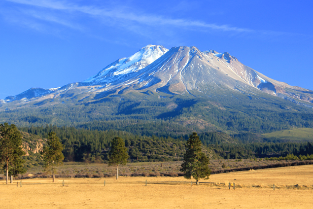
Mount Shasta
Mount Shasta ( Shasta: ''Waka-nunee-Tuki-wuki''; Karuk: ''Úytaahkoo'') is a potentially active volcano at the southern end of the Cascade Range in Siskiyou County, California. At an elevation of , it is the second-highest peak in the Cascades and the fifth-highest in the state. Mount Shasta has an estimated volume of , which makes it the most voluminous stratovolcano in the Cascade Volcanic Arc. The mountain and surrounding area are part of the Shasta–Trinity National Forest. Description Mount Shasta is connected to its satellite cone of Shastina, and together they dominate the landscape. Shasta rises abruptly to tower nearly above its surroundings. On a clear winter day, the mountain can be seen from the floor of the Central Valley to the south. The mountain has attracted the attention of poets, authors, and presidents. The mountain consists of four overlapping dormant volcanic cones that have built a complex shape, including the main summit and the prominent and ... [...More Info...] [...Related Items...] OR: [Wikipedia] [Google] [Baidu] |
Angle Of Repose
The angle of repose, or critical angle of repose, of a granular material is the steepest angle of descent or dip relative to the horizontal plane to which a material can be piled without slumping. At this angle, the material on the slope face is on the verge of sliding. The angle of repose can range from 0° to 90°. The morphology of the material affects the angle of repose; smooth, rounded sand grains cannot be piled as steeply as can rough, interlocking sands. The angle of repose can also be affected by additions of solvents. If a small amount of water is able to bridge the gaps between particles, electrostatic attraction of the water to mineral surfaces will increase the angle of repose, and related quantities such as the soil strength. When bulk granular materials are poured onto a horizontal surface, a conical pile will form. The internal angle between the surface of the pile and the horizontal surface is known as the angle of repose and is related to the density ... [...More Info...] [...Related Items...] OR: [Wikipedia] [Google] [Baidu] |
Basalt
Basalt (; ) is an aphanitic (fine-grained) extrusive igneous rock formed from the rapid cooling of low-viscosity lava rich in magnesium and iron (mafic lava) exposed at or very near the surface of a rocky planet or moon. More than 90% of all volcanic rock on Earth is basalt. Rapid-cooling, fine-grained basalt is chemically equivalent to slow-cooling, coarse-grained gabbro. The eruption of basalt lava is observed by geologists at about 20 volcanoes per year. Basalt is also an important rock type on other planetary bodies in the Solar System. For example, the bulk of the plains of Venus, which cover ~80% of the surface, are basaltic; the lunar maria are plains of flood-basaltic lava flows; and basalt is a common rock on the surface of Mars. Molten basalt lava has a low viscosity due to its relatively low silica content (between 45% and 52%), resulting in rapidly moving lava flows that can spread over great areas before cooling and solidifying. Flood basalts are thick sequence ... [...More Info...] [...Related Items...] OR: [Wikipedia] [Google] [Baidu] |
Hotspot (geology)
In geology, hotspots (or hot spots) are volcanic locales thought to be fed by underlying mantle that is anomalously hot compared with the surrounding mantle. Examples include the Hawaii, Iceland, and Yellowstone hotspots. A hotspot's position on the Earth's surface is independent of tectonic plate boundaries, and so hotspots may create a chain of volcanoes as the plates move above them. There are two hypotheses that attempt to explain their origins. One suggests that hotspots are due to mantle plumes that rise as thermal diapirs from the core–mantle boundary. The alternative plate theory is that the mantle source beneath a hotspot is not anomalously hot, rather the crust above is unusually weak or thin, so that lithospheric extension permits the passive rising of melt from shallow depths. Origin The origins of the concept of hotspots lie in the work of J. Tuzo Wilson, who postulated in 1963 that the formation of the Hawaiian Islands resulted from the slow movement of a ... [...More Info...] [...Related Items...] OR: [Wikipedia] [Google] [Baidu] |
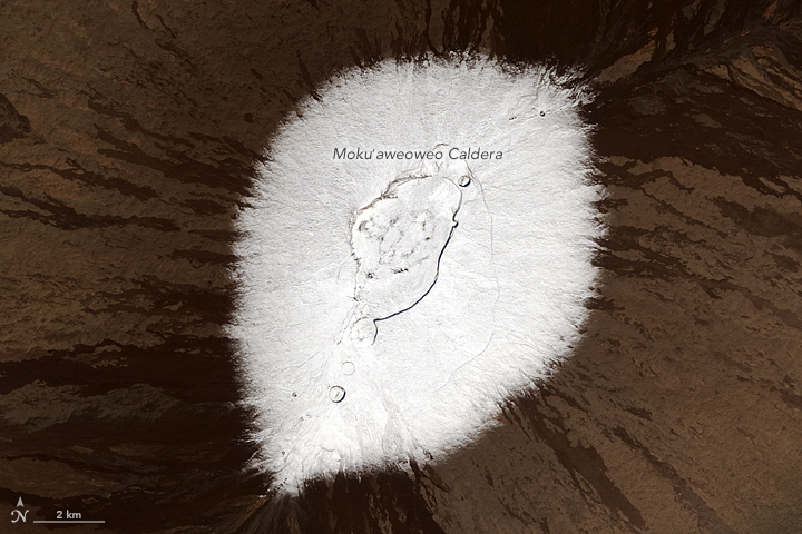
Mauna Loa
Mauna Loa ( or ; Hawaiian: ; en, Long Mountain) is one of five volcanoes that form the Island of Hawaii in the U.S. state of Hawaii in the Pacific Ocean. The largest subaerial volcano (as opposed to subaqueous volcanoes) in both mass and volume, Mauna Loa has historically been considered the largest volcano on Earth, dwarfed only by Tamu Massif. It is an active shield volcano with relatively gentle slopes, with a volume estimated at , although its peak is about lower than that of its neighbor, Mauna Kea. Lava eruptions from Mauna Loa are silica-poor and very fluid, and tend to be non-explosive. Mauna Loa has probably been erupting for at least 700,000 years, and may have emerged above sea level about 400,000 years ago. The oldest-known dated rocks are not older than 200,000 years. The volcano's magma comes from the Hawaii hotspot, which has been responsible for the creation of the Hawaiian island chain over tens of millions of years. The slow drift ... [...More Info...] [...Related Items...] OR: [Wikipedia] [Google] [Baidu] |
Mount Fuji
, or Fugaku, located on the island of Honshū, is the highest mountain in Japan, with a summit elevation of . It is the second-highest volcano located on an island in Asia (after Mount Kerinci on the island of Sumatra), and seventh-highest peak of an island on Earth. Mount Fuji is an active stratovolcano that last erupted from 1707 to 1708. The mountain is located about southwest of Tokyo and is visible from there on clear days. Mount Fuji's exceptionally symmetrical cone, which is covered in snow for about five months of the year, is commonly used as a cultural icon of Japan and it is frequently depicted in art and photography, as well as visited by sightseers and climbers. Mount Fuji is one of Japan's along with Mount Tate and Mount Haku. It is a Special Place of Scenic Beauty and one of Japan's Historic Sites. [...More Info...] [...Related Items...] OR: [Wikipedia] [Google] [Baidu] |
Mount Kilimanjaro
Mount Kilimanjaro () is a dormant volcano in Tanzania. It has three volcanic cones: Kibo, Mawenzi, and Shira. It is the highest mountain in Africa and the highest free-standing mountain above sea level in the world: above sea level and about above its plateau base. It is the highest volcano in Africa and the Eastern Hemisphere. Kilimanjaro is the fourth most topographically prominent peak on Earth. It is part of Kilimanjaro National Park and is a major hiking and climbing destination. Because of its shrinking glaciers and ice fields, which are projected to disappear between 2025 and 2035, it has been the subject of many scientific studies. Toponymy The origin of the name Kilimanjaro is not known, but a number of theories exist. European explorers had adopted the name by 1860 and reported that Kilimanjaro was the mountain's Kiswahili name. The 1907 edition of ''The Nuttall Encyclopædia'' also records the name of the mountain as Kilima-Njaro. Johann Ludwig Kr ... [...More Info...] [...Related Items...] OR: [Wikipedia] [Google] [Baidu] |
Vesuvius
Mount Vesuvius ( ; it, Vesuvio ; nap, 'O Vesuvio , also or ; la, Vesuvius , also , or ) is a somma- stratovolcano located on the Gulf of Naples in Campania, Italy, about east of Naples and a short distance from the shore. It is one of several volcanoes forming the Campanian volcanic arc. Vesuvius consists of a large cone partially encircled by the steep rim of a summit caldera, resulting from the collapse of an earlier, much higher structure. The eruption of Mount Vesuvius in AD 79 destroyed the Roman cities of Pompeii, Herculaneum, Oplontis, Stabiae, and several other settlements. The eruption ejected a cloud of stones, ashes and volcanic gases to a height of , erupting molten rock and pulverized pumice at the rate of per second. More than 1,000 people are thought to have died in the eruption, though the exact toll is unknown. The only surviving eyewitness account of the event consists of two letters by Pliny the Younger to the historian Tacitus. Vesuviu ... [...More Info...] [...Related Items...] OR: [Wikipedia] [Google] [Baidu] |
Pacific Ring Of Fire
The Ring of Fire (also known as the Pacific Ring of Fire, the Rim of Fire, the Girdle of Fire or the Circum-Pacific belt) is a region around much of the rim of the Pacific Ocean where many volcanic eruptions and earthquakes occur. The Ring of Fire is a horseshoe-shaped belt about long and up to about wide. The Ring of Fire includes the Pacific coasts of South America, North America and Kamchatka, and some islands in the western Pacific Ocean. Although there is consensus among geologists about almost all areas which are included in the Ring of Fire, they disagree about the inclusion or exclusion of a few areas, for example, the Antarctic Peninsula and western Indonesia. The Ring of Fire is a direct result of plate tectonics: specifically the movement, collision and destruction of lithospheric plates (e.g. the Pacific Plate) under and around the Pacific Ocean. The collisions have created a nearly continuous series of subduction zones, where volcanoes are created and earthq ... [...More Info...] [...Related Items...] OR: [Wikipedia] [Google] [Baidu] |


