|
Monpa People
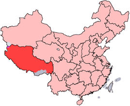
The Monpa ( (;, Chinese: 门巴族) are a major people of Arunachal Pradesh in northeastern India and one of the 56 officially recognized ethnic groups in China. Most Monpas live in the Indian state of Arunachal Pradesh, with a population of 50,000, centered in the districts of Tawang and West Kameng. As of 2020 there were 11,143 Monpa people living in Le / Lebo / Lebugou / Lebugou township of Cona / Tsona City in the south of Tibet Autonomous Region, where they are known as Menba (). Of the 45,000 Monpas who live in Arunachal Pradesh, about 20,000 of them live in Tawang district, where they constitute about 97% of the district's population, and almost all of the remainder can be found in the West Kameng district, where they form about 77% of the district's population. A small number of them may be found in bordering areas of East Kameng and Bhutan (2,500). They also share very close affinity with the Sharchops of Bhutan. Their language belongs to the Tibeto-Burman fa ... [...More Info...] [...Related Items...] OR: [Wikipedia] [Google] [Baidu] |
Arunachal Pradesh
Arunachal Pradesh (; ) is a States and union territories of India, state in northeast India. It was formed from the North-East Frontier Agency (NEFA) region, and India declared it as a state on 20 February 1987. Itanagar is its capital and largest town. It borders the Indian states of Assam and Nagaland to the south. It shares Borders of India, international borders with Bhutan in the west, Myanmar in the east, and a disputed 1,129 km border with China's Tibet Autonomous Region in the north at the McMahon Line. Arunachal Pradesh is claimed in its entirety by China as South Tibet as part of the Tibet Autonomous Region; China Sino-Indian War, occupied some regions of Arunachal Pradesh in 1962 but later withdrew its forces. As of the 2011 Census of India, Arunachal Pradesh has a population of 1,383,727 and an area of . With only 17 inhabitants per square kilometre, it is the least densely populated state of India. It is an ethnically diverse state, with predominantly Monpa p ... [...More Info...] [...Related Items...] OR: [Wikipedia] [Google] [Baidu] |
Tsona City
Tsona City (, zh, s=错那市), formerly Tsona County, is a county-level city in Shannan Prefecture in the southeastern part of the Tibet region of China. Tsona means "The face of the ara Yumcolake" in Tibetan. It lies immediately to the north of the McMahon Line agreed as the mutual border between British India and Tibet in 1914. China has not accepted the 1914 border delineation, but treats it as the Line of Actual Control (LAC). Tsona also borders Bhutan on its southwest. History In 1354, the Phagmodrupa dynasty established Tsona County (''mtsho sna rdzong''). In the 17th century, sectarian rivalries developed between the Gelugpa sect that was in the ascendant in Central Tibet and the Drukpa sect that got consolidated in Bhutan. The Mera lama of the Merag-Sagteng region in present-day Bhutan, belonging to the Gelugpa sect, was chased out of his native village by the Drukpa forces. He fled to the neighbouring Tawang region. The people of Tawang were apparently indiffe ... [...More Info...] [...Related Items...] OR: [Wikipedia] [Google] [Baidu] |
Bayi District
Bayi or Chagyib District ( or ), formerly Nyingchi County, is a District of Nyingchi in the Tibet Autonomous Region, China. Bayi Town, the administrative capital of Nyingchi, is located within the district. History In 1951, modern administrative structures formally integrated the area, initially establishing it as Nyingchi County. In 2015, it was upgraded to a district, adopting the name "Bayi", derived from the district’s main urban area, Bayi Town. This town, developed post-1950s, became a key logistical and transportation node due to its strategic position on the Sichuan-Tibet Highway. Geography Bayi is located in the middle reaches of the Yarlung Tsangpo River. Both steep cliffs and flat valleys exist in the area. The average altitude is 3000 metres above sea level. "The lowest places are just around 1,000 metres above sea level." There are many scenic places in or near Bayi. The Seche La Mountain Scenic Spot, in the east of Nyingchi County, is a part of the Nyainqe ... [...More Info...] [...Related Items...] OR: [Wikipedia] [Google] [Baidu] |
Pêlung
An alphabetical list of populated places, including cities, towns, and villages, in the Tibet Autonomous Region of western China. A *Alamdo *Alhar *Arza *Asog B * Baga *Bagar * Baidi *Baima * Baimai *Baixoi *Bamda *Banag *Banbar *Banggaidoi *Bangkor *Bangru *Bangxing * Baqên *Bar * Bêba *Bei *Bênqungdo *Bilung *Birba * Biru *Bogkamba *Boindoi * Bolo *Bongba * Boqê *Bumgyê *Bungona’og *Bünsum * Burang *Bushêngcaka C * Caina *Cakaxiang *Camco *Cawarong * Cazê *Cêgnê *Cêngdo *Cêri *Cêrwai *Chabug *Chacang *Chagla *Chagna *Chagyoi *Cha’gyüngoinba *Chalükong *Chamco *Chamda *Chamoling *Changgo *Changlung *Changmar *Charing *Chatang *Chawola *Chêcang *Chênggo *Chepzi *Chibma *Chido *Chigu *Chongkü *Chongsar *Chowa *Chubalung *Chubarong *Chuka *Chumba *Chumbu *Chunduixiang *Co Nyi *Cocholung * Codoi * Cogo * Coka *Comai *Cona (Tsona) *Co’nga * Congdü *Conggo * Coqên *Coyang * Cuoma * Cuozheqiangma D *Dagdong *Dagmo *Dagri *Dagring *Dagzhuka *Dakyun ... [...More Info...] [...Related Items...] OR: [Wikipedia] [Google] [Baidu] |
Tsona County
Tsona City (, zh, s=错那市), formerly Tsona County, is a county-level city in Shannan Prefecture in the southeastern part of the Tibet region of China. Tsona means "The face of the ara Yumcolake" in Tibetan. It lies immediately to the north of the McMahon Line agreed as the mutual border between British India and Tibet in 1914. China has not accepted the 1914 border delineation, but treats it as the Line of Actual Control (LAC). Tsona also borders Bhutan on its southwest. History In 1354, the Phagmodrupa dynasty established Tsona County (''mtsho sna rdzong''). In the 17th century, sectarian rivalries developed between the Gelugpa sect that was in the ascendant in Central Tibet and the Drukpa sect that got consolidated in Bhutan. The Mera lama of the Merag-Sagteng region in present-day Bhutan, belonging to the Gelugpa sect, was chased out of his native village by the Drukpa forces. He fled to the neighbouring Tawang region. The people of Tawang were apparently indiffe ... [...More Info...] [...Related Items...] OR: [Wikipedia] [Google] [Baidu] |
East Kameng District
East Kameng district is one of districts of Arunachal Pradesh state in northeastern, India. It shares an international border with China in the north and district borders with West Kameng district to the west, Pakke-Kessang district to the south, Kurung Kumey district to the east, Papum Pare district to the southeast. Pakke-Kessang district was bifurcated from East Kameng district on 1 December 2018. History The area around the Kameng river has at various times come under the control and influence of the Mon kingdom, Tibet Aka and Nishi chiefs would exert control over the area whenever no major political powers dominated the area. The Kameng Frontier Division was renamed the Kameng District. The Political Officer was also redesignated as the Deputy Commissioner of Kameng. However, for political reasons, the Kameng district was bifurcated between East Kameng and West Kameng on 1 June 1980. Geography Before the bifurcation, East Kameng district occupied an area of , compa ... [...More Info...] [...Related Items...] OR: [Wikipedia] [Google] [Baidu] |
West Kameng District
West Kameng (pronounced ) is a district of Arunachal Pradesh in northeastern India. It accounts for 8.86% of the total area of the state. The name is derived from the Kameng river, a tributary of the Brahmaputra, that flows through the district. History The area around the Kameng river has traditionally come under the control of the Mon kingdom, Bhutan, Tibet and the Ahom kingdom. Tibetan Buddhism got a strong foothold among the tribal groups as early as in the 7th century, where the Kachen Lama constructed the Lhagyala Gompa in Morshing. Whenever loose control was exerted over the area, small, feudal chiefdoms ruled by the Miji and the Aka chiefs dominated control over the area. This can be evidenced in the fact that ruined fortresses like those in Bhalukpong constructed in the 10th to 12th century and the Dirang fort, which was constructed in the 17th century to defend against invasions from neighbouring chiefdoms. Upon the arrival of the British, the present- ... [...More Info...] [...Related Items...] OR: [Wikipedia] [Google] [Baidu] |
Tawang District
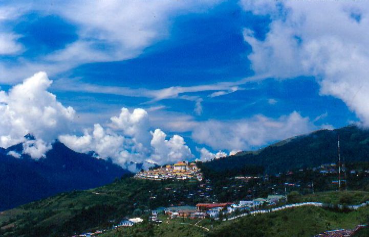
Tawang district (Pron:/tɑ:ˈwæŋ or təˈwæŋ/) is the smallest of the 26 Districts of Arunachal Pradesh, administrative districts of Arunachal Pradesh state in northeastern India. With a population of 49,977, it is the eighth least populous district in the country (out of Districts of India, 707). History Tawang is inhabited by the Monpa people. From 500 BC to 600 AD a kingdom known as Lhomon or Monyul ruled the area. The Monyul kingdom was later absorbed into the control of neighbouring Bhutan and Tibet. Tawang Monastery was founded by the Merak Lama Lodre Gyatso in 1681 in accordance with the wishes of the 5th Dalai Lama, Ngawang Lobsang Gyatso, and has an interesting legend surrounding its name, which means "Chosen by Horse". The sixth Dalai Lama, Tsangyang Gyatso, 6th Dalai Lama, Tsangyang Gyatso, was born in Tawang. Tawang was historically part of Tibet. The Simla Accord (1914), 1914 Simla Accord defined the McMahon Line as the new boundary between British India a ... [...More Info...] [...Related Items...] OR: [Wikipedia] [Google] [Baidu] |
Lepcha People
The Lepcha (; also called Rongkup ( Lepcha: , ''Mútuncí Róngkup Rumkup'', "beloved children of the Róng and of God") and Rongpa ( Sikkimese: )) are among the indigenous people of the Indian state of Sikkim and Nepal, and number around 80,000. Many Lepcha are also found in western and southwestern Bhutan, Darjeeling, the Koshi Province of eastern Nepal, and in the hills of West Bengal. The Lepcha people are composed of four main distinct communities: the Renjóngmú of Sikkim; the Dámsángmú of Kalimpong, Kurseong, and Mirik; the ʔilámmú of Ilam District, Nepal; and the Promú of Samtse and Chukha in southwestern Bhutan. Origins Lepchas are said to have migrated from Cambodia and Tibet having a similar culture, dressup, traits and history. They speak a Tibeto-Burman language which some classify as Himalayish. Others suggest a more complex migration, a migration to Cambodia, then a navigation of the Ayeyarwady River and Chindwin Rivers, a crossing of the Patko ... [...More Info...] [...Related Items...] OR: [Wikipedia] [Google] [Baidu] |
Assam Himalaya
Assam Himalaya is a traditional designation for the portion of the Himalaya range between the eastern border of Bhutan, on the west, and the Great Bend of the Tsangpo River, on the east. The highest peak of this range is Namcha Barwa. Other high peaks include Gyala Peri, sister peak to Namcha Barwa; Kangto, and Nyegyi Kansang. The area is still poorly surveyed in general, and little visited by outsiders. It is located in the eastern side. The name "Assam Himalaya" is misleading, as some parts of this range are in southeastern Tibet, while other parts are in Bhutan and the Indian regions and states of northern Assam, Sikkim, and Arunachal Pradesh Arunachal Pradesh (; ) is a States and union territories of India, state in northeast India. It was formed from the North-East Frontier Agency (NEFA) region, and India declared it as a state on 20 February 1987. Itanagar is its capital and la .... References Sources *''High Asia: An Illustrated History of the 7000 Metre Peaks' ... [...More Info...] [...Related Items...] OR: [Wikipedia] [Google] [Baidu] |
Tibetan Script
The Tibetan script is a segmental writing system, or '' abugida'', forming a part of the Brahmic scripts, and used to write certain Tibetic languages, including Tibetan, Dzongkha, Sikkimese, Ladakhi, Jirel and Balti. Its exact origins are a subject of research but is traditionally considered to be developed by Thonmi Sambhota for King Songtsen Gampo. The printed form is called uchen script while the hand-written form used in everyday writing is called umê script. This writing system is especially used across the Himalayan Region. History Little is known about the exact origins of Tibetan script. According to Tibetan historiography, it was developed during the reign of King Songtsen Gampo by his minister Thonmi Sambhota, who was sent to India along with other scholars to study Buddhism along with Sanskrit and other brahmi languages. They developed the Tibetan script from the Gupta script while at the Pabonka Hermitage. This occurred , towards the beginning of ... [...More Info...] [...Related Items...] OR: [Wikipedia] [Google] [Baidu] |
Tibeto-Burman
The Tibeto-Burman languages are the non- Sinitic members of the Sino-Tibetan language family, over 400 of which are spoken throughout the Southeast Asian Massif ("Zomia") as well as parts of East Asia and South Asia. Around 60 million people speak Tibeto-Burman languages. The name derives from the most widely spoken of these languages, Burmese and the Tibetic languages, which also have extensive literary traditions, dating from the 12th and 7th centuries respectively. Most of the other languages are spoken by much smaller communities, and many of them have not been described in detail. Though the division of Sino-Tibetan into Sinitic and Tibeto-Burman branches (e.g. Benedict, Matisoff) is widely used, some historical linguists criticize this classification, as the non-Sinitic Sino-Tibetan languages lack any shared innovations in phonology or morphology to show that they comprise a clade of the phylogenetic tree. History During the 18th century, several scholars noticed parallel ... [...More Info...] [...Related Items...] OR: [Wikipedia] [Google] [Baidu] |


