|
Monach Islands
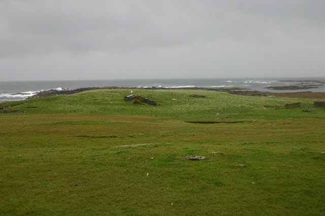
The Monach Islands, also known as Heisker ( gd, Eilean Heisgeir / , ), are an island group west of North Uist in the Outer Hebrides of Scotland. The islands are not to be confused with Hyskeir in the Inner Hebrides, or Haskeir which is also off North Uist and visible from the group. Geology and geography The main islands of (once home to a nunnery), and Shivinish () are all linked at low tide. It has been claimed that it was at one time possible to walk all the way to Baleshare, and on to North Uist, five miles away at low tide. In the 17th century, a large tidal wave is said to have washed this route away. The islands of the group tend to be low-lying and sandy, subject to intense coastal erosion. Not unlike the Isles of Scilly it is possible that , Shivinish and formed a single body of land within historic times, and that their land area has greatly decreased due to overgrazing, sea inundation, and wind erosion. Smaller islands in the group include Deasker (), Shillay ... [...More Info...] [...Related Items...] OR: [Wikipedia] [Google] [Baidu] |
Hyskeir
Hyskeir ( gd, Òigh-sgeir) or Heyskeir is a low-lying rocky islet (a skerry) in the Inner Hebrides, Scotland. The Hyskeir Lighthouse marks the southern entrance to the Minch. Geography Hyskeir lies in the southern entrance to the Minch, 10 kilometres southwest of the island of Canna and 14 kilometres west of Rùm. Garbh Sgeir is a rock that lies next to the islet and the landing place for Hyskeir lies in the channel between the two. Both islands are unoccupied. Òigh-sgeir is composed of hexagonal pitchstone columns. The owner of the island in the 19th and early 20th centuries was Philip Ollas. At that time sheep from Canna were brought to make use of the summer grazing. Etymology Hyskeir is from the Old Norse ''sker'' meaning skerry. ''Òigh-sgeir'' is Gaelic for 'maiden' or 'virgin rock', ''sgeir'' also meaning skerry. The English name 'Maiden Rock' has also been used. Lighthouse Hyskeir Lighthouse was established in 1904. The building marks the southern end of the M ... [...More Info...] [...Related Items...] OR: [Wikipedia] [Google] [Baidu] |
Shillay, Monach Islands
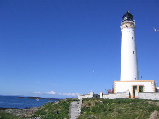
Shillay (Scottish Gaelic: Siolaigh or Seilaigh from the Norse ''selrey'', meaning Seal island) is the westernmost of the Monach Islands (Heisgeir), off North Uist in the Outer Hebrides. Geology and geography Like most of the other Monach Islands, Shillay has a thin, sandy soil, which has been much troubled by erosion, and which was badly eroded by a huge wave in the 16th century. Despite Ceann Iar's name, meaning "western headland", Shillay is the westernmost island of the group. There are several small islets around Shillay, including Eilean Siorraidh, Odarum (to the north) and Raisgeir. Lighthouses The lighthouse at Shillay has an uneven history. The red brick lighthouse was built in 1864 by David & Thomas Stevenson, and was in use until it was closed during the war in 1942 and not lit again in 1948 after hostilities ceased. After the Braer disaster in 1993 in Shetland, a new light was recommended to mark the deep water route west of the Hebrides. A new automated a ... [...More Info...] [...Related Items...] OR: [Wikipedia] [Google] [Baidu] |
Jacobitism
Jacobitism (; gd, Seumasachas, ; ga, Seacaibíteachas, ) was a political movement that supported the restoration of the senior line of the House of Stuart to the Monarchy of the United Kingdom, British throne. The name derives from the first name of James II and VII, which in Latin translates as ''Jacobus (name), Jacobus''. When James went into exile after the November 1688 Glorious Revolution, the Parliament of England argued that he had abandoned the Kingdom of England, English throne, which they offered to his Protestant daughter Mary II, and her husband William III of England, William III. In April, the Convention of Estates (1689), Scottish Convention held that he "forfeited" the throne of Scotland by his actions, listed in the Articles of Grievances. The Revolution thus created the principle of a contract between monarch and people, which if violated meant the monarch could be removed. Jacobites argued monarchs were appointed by God, or Divine right of kings, divine right, a ... [...More Info...] [...Related Items...] OR: [Wikipedia] [Google] [Baidu] |
The Scotsman
''The Scotsman'' is a Scottish compact newspaper and daily news website headquartered in Edinburgh. First established as a radical political paper in 1817, it began daily publication in 1855 and remained a broadsheet until August 2004. Its parent company, JPIMedia, also publishes the ''Edinburgh Evening News''. It had an audited print circulation of 16,349 for July to December 2018. Its website, Scotsman.com, had an average of 138,000 unique visitors a day as of 2017. The title celebrated its bicentenary on 25 January 2017. History ''The Scotsman'' was launched in 1817 as a liberal weekly newspaper by lawyer William Ritchie and customs official Charles Maclaren in response to the "unblushing subservience" of competing newspapers to the Edinburgh establishment. The paper was pledged to "impartiality, firmness and independence". After the abolition of newspaper stamp tax in Scotland in 1855, ''The Scotsman'' was relaunched as a daily newspaper priced at 1d and a circul ... [...More Info...] [...Related Items...] OR: [Wikipedia] [Google] [Baidu] |
Lochmaddy
Lochmaddy ( gd, Loch nam Madadh, "Loch of the Hounds") is the administrative centre of North Uist in the Outer Hebrides, Scotland. ''Na Madaidhean'' (the wolves/hounds) are rocks in the bay after which the loch, and subsequently the village, are named. Lochmaddy is within the parish of North Uist. Geography Lochmaddy lies on the sea loch of that name and, due to the rocky nature of the coast, is the only settlement of any size on the east coast. Most of the island's settlements are on the west coast. Lochmaddy is at the eastern end of the A865 and close to the eastern end of the A867; these are the only two main roads on the island. History Virtually the first mention anywhere of Lochmaddy is a complaint of "piracie and murder" in a report dated 1616: "Lochmaldie on the coast of Uist is a rendezvous for pirates" it said. The coves and inlets around the village were ideal hiding places for raiding ships stocked with fine goods bound for the clan chiefs of the time, and contraba ... [...More Info...] [...Related Items...] OR: [Wikipedia] [Google] [Baidu] |
Grimsay
Grimsay ( gd, Griomasaigh) is a tidal island in the Outer Hebrides of Scotland. Geography Grimsay is the largest of the low-lying stepping-stones which convey the Oitir Mhòr (North Ford) causeway, a arc of single track road linking North Uist and Benbecula via the western tip of Grimsay. Until it opened in 1960, a ferry linked Carinish (on North Uist) with Gramsdale (on Benbecula), but could only operate at high tide. There was also a ford which could only be crossed close to low water, usually only with a guide. For significant parts of each day the North Ford was too wet to ford and not wet enough to cross by ferry. East of Grimsay lie several smaller islands including Ronay which was inhabited until 1931. Inhabitants The island's population was 169 as recorded by the 2011 census a drop of over 15% since 2001 when there were 201 usual residents. During the same period Scottish island populations as a whole grew by 4% to 103,702. The main settlements are Baymore (''Bàgh ... [...More Info...] [...Related Items...] OR: [Wikipedia] [Google] [Baidu] |
Northern Lighthouse Board
The Northern Lighthouse Board (NLB) is the general lighthouse authority for Scotland and the Isle of Man. It is a non-departmental public body responsible for marine navigation aids around coastal areas. History The NLB was formed by Act of Parliament in 1786 as the Commissioners of Northern Light Houses, largely at the urging of the lawyer and politician George Dempster ("Honest George"), to oversee the construction and operation of four Scottish lighthouses: Kinnaird Head, North Ronaldsay, Scalpay and Mull of Kintyre, for which they were empowered to borrow up to £1,200. Until then, the only major lighthouse in Scotland was the coal brazier mounted on the Isle of May in the Firth of Forth, together with some smaller lights in the Firths of the Tay and Clyde. None of the major passages around Scotland, which led through dangerous narrows, were marked. The commissioners, whose first president was the Lord Provost of Edinburgh, Sir James Hunter-Blair, advertised for buildin ... [...More Info...] [...Related Items...] OR: [Wikipedia] [Google] [Baidu] |
MV Braer
The MV ''Braer'' was an oil tanker which ran aground during a storm off Shetland, Scotland, in January 1993, and nearly a week later broke up during the most intense extratropical cyclone on record for the northern Atlantic Ocean, the Braer Storm of January 1993. Design and history The MV ''Braer'' was originally launched as the ''Hellespoint Pride'' and was constructed by Oshima Shipbuilding Company in 1975. The Braer was originally owned by Tucana Shipping Company of Singapore before being purchased by the Hancock Shipping Company registered in Monrovia when she was renamed ''Brae Trader.'' She was named ''Braer'' when she was acquired by the Braer Corporation in 1990. Reason for ship's loss During the enquiry after the ship's loss, it was stated that the ship lost power due to seawater contamination of the ship's heavy fuel oil on 3 January. This occurred after a pipeline on the deck broke loose, allowing seawater to enter the vessel's bunker tanks via broken air vents. The ... [...More Info...] [...Related Items...] OR: [Wikipedia] [Google] [Baidu] |
Thomas Stevenson
Thomas Stevenson PRSE MInstCE FRSSA FSAScot (22 July 1818 – 8 May 1887) was a pioneering Scottish civil engineer, lighthouse designer and meteorologist, who designed over thirty lighthouses in and around Scotland, as well as the Stevenson screen used in meteorology. His designs, celebrated as ground breaking, ushered in a new era of lighthouse creation. He served as president of the Royal Scottish Society of Arts (1859–60), as president of the Royal Society of Edinburgh (1884–86), and was a co-founder of the Scottish Meteorological Society. Life He was born at 2 Baxters Place in Edinburgh, on 22 July 1818, the youngest son of engineer Robert Stevenson, and his wife (and step-sister) Jean Smith. He was educated at the Royal High School in Edinburgh. Thomas Stevenson was a devout and regular attendee at St. Stephen's Church in Stockbridge, at the north end of St Vincent Street, Edinburgh. He lived with his family at Baxters Place until he got married in 1848. He then go ... [...More Info...] [...Related Items...] OR: [Wikipedia] [Google] [Baidu] |
David Stevenson (engineer)
David Stevenson MICE FRSE FRSSA (11 January 1815 – 17 July 1886) was a Scottish lighthouse designer, who designed over 30 lighthouses in and around Scotland, and helped continue the dynasty of lighthouse engineering founded by his father. Life He was born on 11 January 1815 at 2 Baxters Place at the top of Leith Walk in Edinburgh, the son of Jean Smith and engineer Robert Stevenson. He was brother of the lighthouse engineers Alan and Thomas Stevenson. He was educated at the High School in Edinburgh then studied at the University of Edinburgh. In 1838 he became a partner in his father's (and uncle's) firm of R & A Stevenson. In 1844 he was elected a Fellow of the Royal Society of Edinburgh his proposer being David Milne-Home. In 1853 he moved to the Northern Lighthouse Board. Between 1854 and 1880 he designed many lighthouses, all with his brother Thomas. In addition he helped Richard Henry Brunton design lighthouses for Japan, inventing a novel method for allowing them to ... [...More Info...] [...Related Items...] OR: [Wikipedia] [Google] [Baidu] |
Highland Clearances
The Highland Clearances ( gd, Fuadaichean nan Gàidheal , the "eviction of the Gaels") were the evictions of a significant number of tenants in the Scottish Highlands and Islands, mostly in two phases from 1750 to 1860. The first phase resulted from agricultural improvement, driven by the need for landlords to increase their income – many had substantial debts, with actual or potential bankruptcy being a large part of the story of the clearances. This involved the enclosure of the open fields managed on the run rig system and shared grazing. These were usually replaced with large-scale pastoral farms on which much higher rents were paid. The displaced tenants were expected to be employed in industries such as fishing, quarrying or the kelp industry. Their reduction in status from farmer to crofter was one of the causes of resentment. The second phase involved overcrowded crofting communities from the first phase that had lost the means to support themselves, through famine ... [...More Info...] [...Related Items...] OR: [Wikipedia] [Google] [Baidu] |
Overgrazing
Overgrazing occurs when plants are exposed to intensive grazing for extended periods of time, or without sufficient recovery periods. It can be caused by either livestock in poorly managed agricultural applications, game reserves, or nature reserves. It can also be caused by immobile, travel restricted populations of native or non-native wild animals. Overgrazing reduces the usefulness, productivity, and biodiversity of the land and is one cause of desertification and erosion. Overgrazing is also seen as a cause of the spread of invasive species of non-native plants and of weeds. Degrading land, emissions from animal agriculture and reducing the biomass in a ecosystem contribute directly to climate change. Overgrazing can be reversed or prevented by removing grazers in order to give plants time to recover between grazing events. Successful planned grazing strategies have been support in the American bison of the Great Plains, or migratory Wildebeests of the African savann ... [...More Info...] [...Related Items...] OR: [Wikipedia] [Google] [Baidu] |
.jpg)


