|
Miyapadavu
Miyapadavu is a small village of Meenja Panchayath of Manjeshwar taluk Kasaragod district, Kerala state, India. Location Miyapadavu is located east of Hosangadi junction in Majeshwar. It is 7.5 kilometers away from Hosangadi junction. Transportation Miyapadavu can be accessed by bus from Uppala, Hosangadi/Manjeshwar Manjeshwar is a town and a minor port in Kasaragod district at the northern tip of Kerala. It is situated at a distance of from the state capital Thiruvananthapuram, north of district HQ Kasaragod and south of Mangalore city in neighbou ... towns. Image gallery File:Miyapadavu. Ayyappa temple.jpg, Ayyappa Temple File:Miyapadavu school.jpg, Primary School File:Miyapadavu Junction.jpg, Miyapadavu Junction File:Miyapadavu Mosque.jpg, Noor Masjidh References {{coord, 12.714, 74.953, type:city_region:IN, display=title Villages in Kasaragod district ... [...More Info...] [...Related Items...] OR: [Wikipedia] [Google] [Baidu] |
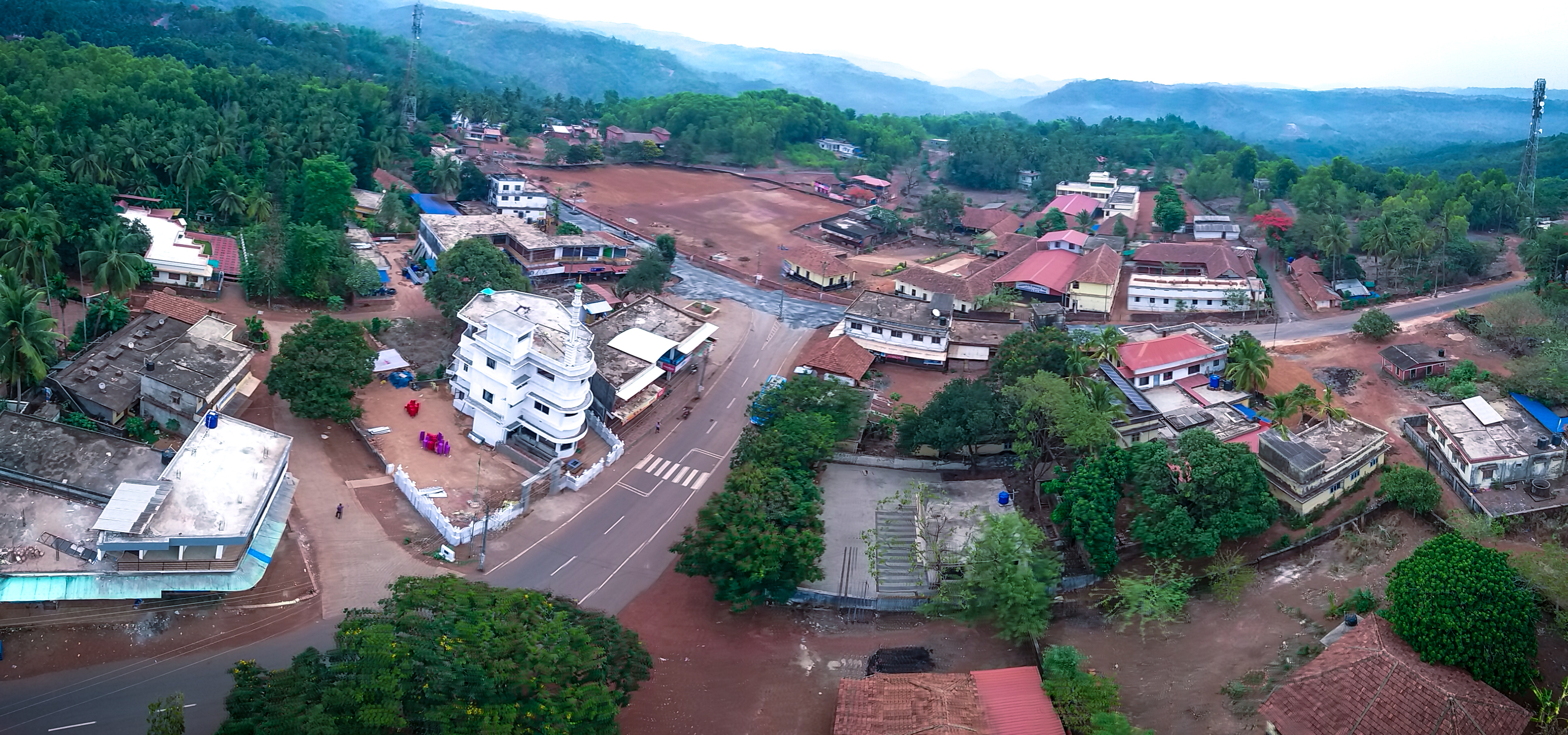
Miyapadavu Ariel View
Miyapadavu is a small village of Meenja Panchayath of Manjeshwar taluk Kasaragod district, Kerala state, India. Location Miyapadavu is located east of Hosangadi junction in Majeshwar. It is 7.5 kilometers away from Hosangadi junction. Transportation Miyapadavu can be accessed by bus from Uppala, Hosangadi/ Manjeshwar towns. Image gallery File:Miyapadavu. Ayyappa temple.jpg, Ayyappa Temple File:Miyapadavu school.jpg, Primary School File:Miyapadavu Junction.jpg, Miyapadavu Junction File:Miyapadavu Mosque.jpg, Noor Masjidh References {{coord, 12.714, 74.953, type:city_region:IN, display=title Villages in Kasaragod district ... [...More Info...] [...Related Items...] OR: [Wikipedia] [Google] [Baidu] |
Kasaragod District
Kasaragod ( and Malayalam language, Malayalam: , English language, English: ''Kassergode'', Tulu language, Tulu: ''Kasrod'', Arabic language, Arabic: ''Harkwillia'') is one of the 14 List of districts of Kerala, districts in the southern Indian state of Kerala. Its northern border Thalappady, Kasaragod, Thalappady is located just 10 km south to Ullal, which is the southernmost portion of the major port city Mangalore, on the southwestern Malabar coast of India. Kasaragod is the northernmost district of Kerala and is also known as ''Saptha Bhasha Sangama Bhoomi'' (The land of seven languages) as seven languages namely, Malayalam, Tulu language, Tulu, Kannada, Marathi language, Marathi, Konkani, Beary language, Beary, and Urdu are spoken, unlike the other districts of Kerala. The district is situated on the rich biodiversity of Western Ghats. It was a part of the Kannur district of Kerala until 24 May 1984. The district is bounded by Dakshina Kannada district to the north, ... [...More Info...] [...Related Items...] OR: [Wikipedia] [Google] [Baidu] |
Maheshwar
Maheshwar is a town, near Khargone city in Khargone district of Madhya Pradesh state, in central India. It is located on State Highway-38 ( Khargone city-Barwaha- Bandheri Highway),13.5 km east of National Highway 3 (Agra-Mumbai highway) and 91 km from Indore, the commercial capital of the state. The Town lies on the north bank of the Narmada River. It was the kingdom of Chaktavartin Samrat Sahastraarjun, Kartavirya Arjuna a Heheya king. Lately, after many years, it was the capital of the Malwa during the Maratha Holkar reign till 6 January 1818, when the capital was shifted to Indore by Malhar Rao Holkar III. Etymology The word Maheshwar in Hindi means ''Great God, ''an epithet of Lord Shiva. History Writers such as HD Sankalia, PN Bose and Francis Wilford, among others, identify Maheshwar as the ancient town of Mahishmati. Also known as Minnagara to Greeko-Romans. Maheshwar is believed to be built on the site of the ancient city of Somvanshya Shastrarjun ... [...More Info...] [...Related Items...] OR: [Wikipedia] [Google] [Baidu] |
Uppala
Uppala is a town and Headquarters of Manjeshwaram Taluk in Kasaragod district, Kerala, India. It is geographically located midway from Kasaragod to Mangalore. Easy geographical access and lack of major towns nearby are the key reasons for the town to develop exponentially, especially in the past decade. The population of Manjeshwaram Taluk alone was over 268,642 as of 2011. Uppala is 22 km north of Kasaragod and one of the fastest growing urban settlements in Kasaragod district. It is well known as an important trade hub in the northernmost part of Kerala state. Location Uppala is located midway between Kasaragod and Mangalore. It is around 22 km north of Kasaragod and 24 km south of Mangalore . Uppala is located about 586 km north of the state capital, Thiruvananthapuram. National Highway 66, which used to be known as NH 17, passes through the town. Uppala used to be known as Kurchipalla. Uppala is located near the Arabian sea, and has a very low eleva ... [...More Info...] [...Related Items...] OR: [Wikipedia] [Google] [Baidu] |
Manjeshwar
Manjeshwar is a town and a minor port in Kasaragod district at the northern tip of Kerala. It is situated at a distance of from the state capital Thiruvananthapuram, north of district HQ Kasaragod and south of Mangalore city in neighbouring Karnataka. It is a coastal town in Kasaragod district. Demographics The Manjeshwar Census Town (CT) has an area of 3.98 km² with population of 8,742 of which 4,178 are males while 4,564 are females as per report released by Census India 2011. The Population of Children with age of 0-6 is 1149 which is 13.14% of the total population of Manjeshwar (CT). In Manjeshwar Census Town, the Female Sex Ratio is of 1092 against the state average of 1084. Moreover, the Child Sex Ratio in Manjeshwar is around 995 compared to the Kerala state average of 964. Literacy rate of Manjeshwar city is 92.91%, which is lower than the state average of 94.00%. In Manjeshwar, male literacy is around 97.53% while female literacy is 88.75%. Religions As per 2 ... [...More Info...] [...Related Items...] OR: [Wikipedia] [Google] [Baidu] |


