|
Middelsee
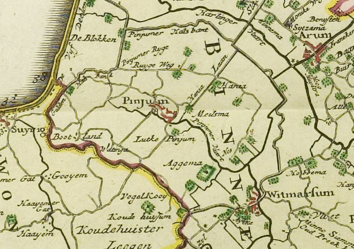
The Middelzee (Dutch for "middle sea"; fry, Middelsee), also called Bordine, was the estuary mouth of the River Boorne (West Frisian: ''Boarn'') now in the Dutch province of Friesland. It ran from as far south as Sneek northward to the Wadden Sea and marked the border between main Frisian regions of Westergoa (Westergo) and Eastergoa (Oostergo). Other historical names for the Middelzee include Bordaa, Borndiep, Boerdiep, and Bordena. The names like Bordine, mean "border". Pre-history Back in the Pleistocene the Boorne was a river that had a drainage basin in Friesland, Drenthe, and Groningen. It flowed from Saalien glacial till plateau in a southwest direction, and met the sea west of Het Bildt. The Boorne passed the current location of Akkrum and Rauwerd. The connection to the Wadden Sea became blocked by sand dunes in the Weichselian time period, and the mouth of the river was forced more and more easterly, until it was heading in a north-northwest direction from Akkrum. ... [...More Info...] [...Related Items...] OR: [Wikipedia] [Google] [Baidu] |
Eastergoa
Eastergoa (also Ostergau, Ostergo, or Oostergo) was one of the seven areas and one of the three '' Gaue'' within what is today the province of Friesland in the Netherlands. Area On its west side Eastergoa was bordered by the Middelsee with Westergoa on the other side of the water. To the south the Alde Leppedyk and the Boarn were the border with , and later with ( nl, Zeuvenwoolden). To the east it was bordered by the Lauwers, the Lauwerzee and the Westerkwartier of the Ommelanden (the western portion of the today's province of Groningen). 1200 The whole of this area belonged to Wininge and Achtkarspelen, which was at that point still a part of Eastergoa. Around 1200 Wininge comprised Dantumadeel, Dongeradeel and Ferwerderadeel ( fy, Dantumadiel, Dongeradiel, longname=yes and ') in the north and , Leeuwarderadeel and Tietjerksteradeel in the south ( fy, Idaarderadiel, Ljouwerteradiel, longname=yes, links=no and '). Around 1250 it was split into two parts called th ... [...More Info...] [...Related Items...] OR: [Wikipedia] [Google] [Baidu] |
Westergoa
Westergoa was one of the seven sealands and one of the three that now lie within the borders of today's Dutch province of Friesland. Later it was one of the three goaen of Frisia. In the Middle Ages Westergoa most probably formed the political centre of the Frisian realm. Area On the eastern side Westergoa was bordered by the Middelsee, on the other side Eastergoa. On the south side it bordered with what originally was Bornegoa which was in the line with Terhernster Lake to the south of the coast, the eastern perimeter was with Doedingwerstal. All other borders were coastlines. 1200 Around 1200, Westergoa was divided into parts within the Westergoa area Franeker, Wildinge and Wymbrits, called the Fiefdielen (Five parts). Franeker and Wildinge have probably been the original Westergo. Wymbrits was added when begin 12th century when Sudergoa was no more. 1500 Around 1500 Het Bildt, was added to Westergoa but by the establishment of Sânwâlden, Gaasterland, Doni ... [...More Info...] [...Related Items...] OR: [Wikipedia] [Google] [Baidu] |
Marne (estuary)
The Marneslenk (Dutch), or Marneslinke (Frisian), or Marne estuary, was a former estuary in western Friesland south of Harlingen, now reclaimed to be farmland. It formed around the year 300 AD, when rising sea levels also enlarged the Almere lake to the southwest, and formed the Middelzee to the east. The Marneslenk had its mouth on the Vlie and stretched southeasterly to the area of Tirns and then headed east to the Middelzee. Between 1100 and 1300 AD the watercourse was reclaimed and turned into fields by the construction of dykes. One such dyke is the Pingjumer Gulden Halsband. The Bedelaarsvaart (Bidlersfeart) and Harnzerfeartis are what remains of this watercourse nowadays. Pre-history In the Pleistocene the Marneslenk existed as a landscape low oriented to the northwest between the Harlingen High to the north east and the Texel high to the southwest. In the northwest end it broadened out between what is now Vlieland and Terschelling It connected at its southeast extremi ... [...More Info...] [...Related Items...] OR: [Wikipedia] [Google] [Baidu] |
Menameradiel
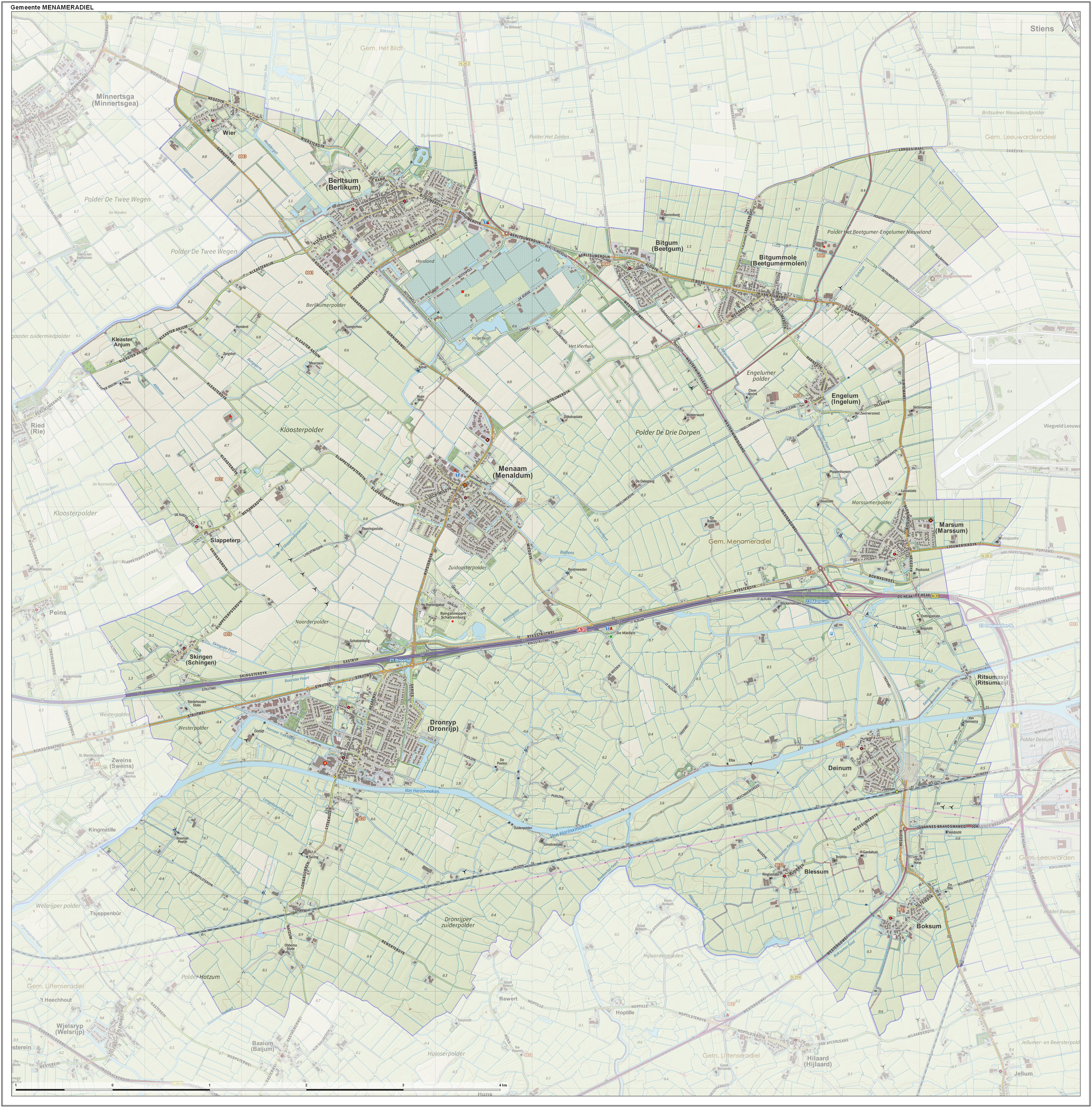
Menameradiel (; nl, Menaldumadeel ) is a former municipality in Friesland, Netherlands. On 1 January 2018 it merged with the municipalities of Franekeradeel, het Bildt and parts of Littenseradiel to form the new municipality Waadhoeke. Population centres Population centres as of 1 January 2007: * Beetgum (754) * Beetgumermolen (944) * Berlikum (2,492) * Blessum (92) * Boksum (449) * Deinum (1,071) * Dronryp (3,427) * Engelum (415) * Kleaster-Anjum (50) * Marssum (1,156) * Menaam (2,612) * Schingen (108) * Slappeterp Slappeterp is a small village in Waadhoeke municipality in the province of Friesland, the Netherlands. It had a population of around 85 in January 2017. History The village was first mentioned in the 13th century Clepesdor. The etymology is uncl ... (80) * Wier (207). Topography ''Dutch Topographic map of the former municipality of Menaldumadeel, June 2015'' References External links * Waadhoeke Former municipalities of Friesland Municip ... [...More Info...] [...Related Items...] OR: [Wikipedia] [Google] [Baidu] |
Leeuwarderadeel
Leeuwarderadeel (; fy, Ljouwerteradiel) is a former municipality in the northern Netherlands. Its capital was Stiens. History On 1 January 2018 it merged with the municipality of Leeuwarden. Population centres * Bartlehiem * Britsum * Cornjum * Finkum * Hijum * Jelsum * Oude Leije * Stiens Topography ''Dutch Topographic map of the municipality of Leeuwarderadeel, June 2015.'' Bartlehiem The hamlet of Bartlehiem is partially in Leeuwarderadeel partially in Ferwerderadiel and partially in Tytsjerksteradiel Tytsjerksteradiel () is a municipality in the province of Friesland in the Netherlands. It is named after the town of Tytsjerk, whose name is derived from a person named Tiete. Tiete was a daughter of Tryn, after whom the region (Trynwâlden) is n .... References External links * Official website Leeuwarden Former municipalities of Friesland Municipalities of the Netherlands disestablished in 2018 {{Friesland-geo-stub ... [...More Info...] [...Related Items...] OR: [Wikipedia] [Google] [Baidu] |
Ferwerderadiel
Ferwerderadiel () is a former municipality of Friesland in the northern Netherlands. Its official name is West Frisian, the Dutch name is Ferwerderadeel (). In 2019 it merged with the municipalities of Dongeradeel and Kollumerland en Nieuwkruisland to form the new municipality Noardeast-Fryslân. Population centres Bartlehiem, Blije, Burdaard, Ferwert, Ginnum, Hallum, Hegebeintum, Jannum, Jislum, Lichtaard, Marrum, Reitsum, Wânswert, Westernijtsjerk. Topography Dutch topographic map of the municipality of Ferwerderadiel, June 2015'' Notable people * Saint Frederick of Hallum (ca. 1113 – 1175) a Premonstratensian priest * Barthold Douma van Burmania (1695 in Hallum – 1766) a Dutch statesman and ambassador to the court of Vienna * Pieter Boeles (1795 in Ferwerd – 1875) a Dutch Minister and linguist * Gerardus Heymans (1857 in Ferwert – 1930) a Dutch philosopher, psychologist and academic * Watse Cuperus (1891 in Blije – 1966) a Dutch journalist and writer ... [...More Info...] [...Related Items...] OR: [Wikipedia] [Google] [Baidu] |
Het Bildt
Het or HET may refer to: Science and technology * Hall-effect thruster, a type of ion thruster used for spacecraft propulsion * Heavy Equipment Transporter, a vehicle in the US Army's Heavy Equipment Transport System * Hobby–Eberly Telescope, an instrument at the University of Texas McDonald Observatory * Human enhancement Technologies, devices for enhancing the abilities of human beings * Heterozygote, a diploid organism with differing alleles at a genetic locus; see zygosity * Hexaethyl tetraphosphate, in chemistry * HET acid, alternate term for Chlorendic acid Other uses * Hét, a village in Hungary * Het peoples, or their language * Heterosexuality, sexual attraction to the opposite sex * ''HighEnd Teen'' (2008–2017), a former Indonesian magazine * Historical Enquiries Team (2005–2014), a former unit of the Police Service of Northern Ireland * Holocaust Educational Trust, a British charity * HET, IATA code for Hohhot Baita International Airport, in Inner Mongolia, Ch ... [...More Info...] [...Related Items...] OR: [Wikipedia] [Google] [Baidu] |
Leeuwarden Air Base
Leeuwarden Air Base ( nl, Vliegbasis Leeuwarden) is a military airbase used by the Royal Netherlands Air Force (RNLAF) - nl, Koninklijke Luchtmacht (''KLu''), . The airbase was formerly one of the two F-16 Fighting Falcon bases of the RNLAF. The airbase lies northwest of the capital of Friesland, Leeuwarden. Leeuwarden Air Base is also one of the three military airbases (together with Gilze-Rijen Air Base and Volkel Air Base) that organise the twice-in-three-years Luchtmachtdagen ('Air Force Days') of the Royal Netherlands Air Force, consisting of air shows and static exhibits. In 2006, 2008, 2011 and 2016 Leeuwarden Air Base hosted these public demonstration days. History The airport of Leeuwarden was built in 1938, and was used as an airport between Schiphol and Eelde. The airport was used only infrequently at first, but that changed after the Germans invaded the Low Countries in 1940. The Luftwaffe used the airport as a base for their fighter aircraft (including th ... [...More Info...] [...Related Items...] OR: [Wikipedia] [Google] [Baidu] |
Nijlân
Nijland ( fry, Nijlân) is a village in Súdwest-Fryslân municipality in the province of Friesland, the Netherlands. It had a population of around 1,000 in January 2017. The coat of arms depicts a pair of oxen linked by a chain, because according to legend a pair of oxen determined the location of the church, and so the village. History The village was first mentioned in 1230 as "de Nova Terra", and means "new land" which is a reference to the '' poldering'' of the southern part of the Middelzee which had silted probably before 1100. The village was sometimes referred to as Dodakerke which means "church founded by Dodo" which is probably the abbot who also founded . Nijland has a concentric structure with the farms placed around the church in a circle. During the 17th and 18th century, a linear extension was added to the south of the village. The tower of the Dutch Reformed church dates from the late-13th century and was enlarged in the 17th century. The church dates from the 16t ... [...More Info...] [...Related Items...] OR: [Wikipedia] [Google] [Baidu] |


