|
Mesaverde Group
The Mesaverde Group is a Late Cretaceous stratigraphic group found in areas of Colorado, New Mexico, Utah, and Wyoming, in the Western United States. History The Mesaverde Formation was first described by W.H.Holmes in 1877 during the Hayden Survey. Holmes described the formation in the northern San Juan Basin as consisting of three units, which were a "Lower Escarpment" consisting of 40 m of ledge- and cliff-forming massive sandstone; a "Middle Coal Group" consisting of up to 300 m of thick slope-forming sandstone, shale, marl, and lignite; and an "Upper Escarpment" consisting of 60 m of ledge- and cliff-forming sandstone. A.J. Collier redesignated these units in 1919 as the Point Lookout Sandstone, the Menefee Formation, and the Cliff House Sandstone, and raised the Mesaverde Formation to group rank. The group was later traced to the greater Green River Basin, the Uintah and Piceance Basins, the Bighorn Basin, the Front Range, the Zuni Basin, the Wasatch Plateau, Win ... [...More Info...] [...Related Items...] OR: [Wikipedia] [Google] [Baidu] |
Book Cliffs
The Book Cliffs are a series of desert mountains and cliffs in western Colorado and eastern Utah in the western United States. They are so named because the cliffs of Cretaceous sandstone that cap many of the south-facing buttes appear similar to a shelf of books. Stratigraphy The Book Cliffs are one of the world's best places to study sequence stratigraphy. In the 1980s, Exxon scientists used the Cretaceous strata of the Book Cliffs to develop the science of sequence stratigraphy. The Book Cliffs have preserved excellent strata of the foreland basin of the ancient Western Interior Seaway that stretched north from the Gulf of Mexico to the Yukon in the Cretaceous Period. Components of deltaic and shallow marine reservoirs are very well preserved in the Book Cliffs. Wildlife Large mammals found in the Book Cliffs include coyotes, mountain lions, bobcats, mule deer, elk, black bears, pronghorn, American bison as an extension of the Henry Mountains bison herd and bighorn sheep. ... [...More Info...] [...Related Items...] OR: [Wikipedia] [Google] [Baidu] |
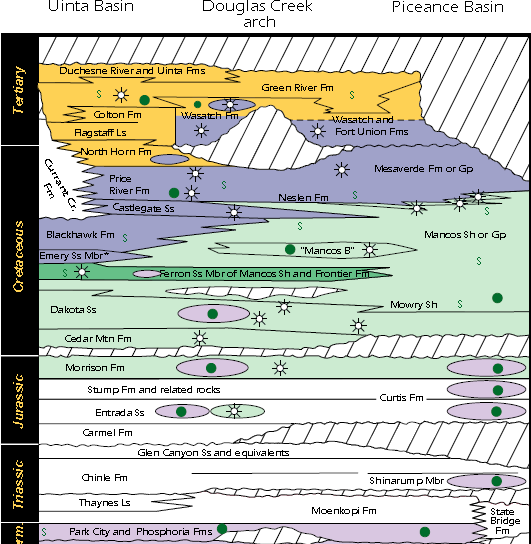
Uinta Piceance Basin Stratigraphic Column
Uinta or Uintah may refer to: People *Ute Indian Tribe of the Uintah and Ouray Reservation, Utah Places * High Uintas Wilderness * Uintah and Ouray Indian Reservation, Utah * Uintah County, Utah * Uinta County, Wyoming * Uinta Mountains, in the state of Utah * Uinta National Forest * Uintah, Utah, a town located in Weber County Other * Uinta chipmunk The Uinta chipmunk or hidden forest chipmunk (''Neotamias umbrinus''), is a species of chipmunk in the family Sciuridae. It is endemic to the United States. Formerly known as ''Tamias umbrinus'', phylogenetic studies have shown it to be sufficie ..., a species of chipmunk, in the family Sciuridae * ''Uinta'' (moth), a genus of moth * Uinta Brewing Company, a craft brewery located in Salt Lake City, Utah {{disambiguation ... [...More Info...] [...Related Items...] OR: [Wikipedia] [Google] [Baidu] |
Piceance Basin
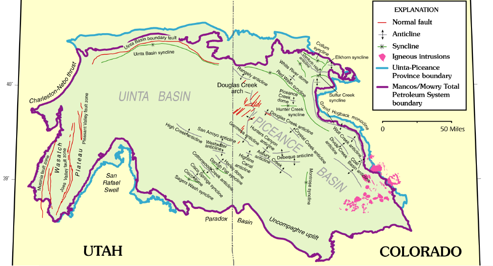
The Piceance Basin is a geologic structural basin in northwestern Colorado, in the United States. It includes geologic formations from Cambrian to Holocene in age, but the thickest section is made up of rocks from the Cretaceous Period. The basin contains reserves of coal, natural gas, and oil shale. The name likely derives from the Shoshoni word ''/piasonittsi/'' meaning “tall grass” (''/pia-/'' ‘big’ and ''/soni-/'' ‘grass’). Hydrocarbon resources In 2016 USGS released an assessment of the resources of the Mancos Shale of the Piceance Basin in Colorado and Utah, "a total of assessed technically recoverable mean resources of 74 million barrels of shale oil, 66.3 trillion cubic feet of gas, and 45 million barrels of natural gas liquids." Natural gas The basin has come to increasing public attention in recent years because of widespread drilling to extract natural gas. The primary target of gas development has been the Williams Fork Formation of the Mesaverde Group, ... [...More Info...] [...Related Items...] OR: [Wikipedia] [Google] [Baidu] |
Uintah Basin
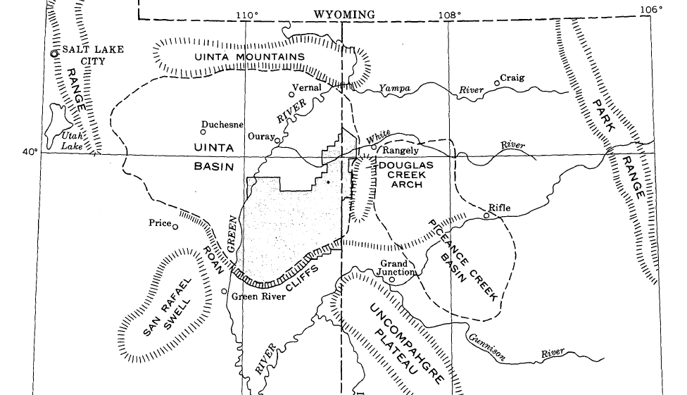
The Uinta Basin (also known as the Uintah Basin) is a physiographic section of the larger Colorado Plateaus province, which in turn is part of the larger Intermontane Plateaus physiographic division. It is also a geologic structural basin in eastern Utah, east of the Wasatch Mountains and south of the Uinta Mountains. The Uinta Basin is fed by creeks and rivers flowing south from the Uinta Mountains. Many of the principal rivers (Strawberry River, Currant Creek, Rock Creek, Lake Fork River, and Uintah River) flow into the Duchesne River which feeds the Green River—a tributary of the Colorado River. The Uinta Mountains forms the northern border of the Uinta Basin. They contain the highest point in Utah, Kings Peak, with a summit 13,528 feet (4123 metres) above sea level. The climate of the Uinta Basin is semi-arid, with occasionally severe winter cold. History Father Escalante's expedition visited the Uinta Basin in September 1776. 1822–1840 French Canadian tra ... [...More Info...] [...Related Items...] OR: [Wikipedia] [Google] [Baidu] |
Green River Basin
Green is the color between cyan and yellow on the visible spectrum. It is evoked by light which has a dominant wavelength of roughly 495570 nm. In subtractive color systems, used in painting and color printing, it is created by a combination of yellow and cyan; in the RGB color model, used on television and computer screens, it is one of the additive primary colors, along with red and blue, which are mixed in different combinations to create all other colors. By far the largest contributor to green in nature is chlorophyll, the chemical by which plants photosynthesize and convert sunlight into chemical energy. Many creatures have adapted to their green environments by taking on a green hue themselves as camouflage. Several minerals have a green color, including the emerald, which is colored green by its chromium content. During post-classical and early modern Europe, green was the color commonly associated with wealth, merchants, bankers, and the gentry, while red was r ... [...More Info...] [...Related Items...] OR: [Wikipedia] [Google] [Baidu] |
Cliff House Sandstone
The Cliff House Sandstone is a late Campanian stratigraphic unit comprising sandstones in the western United States. Description The Cliff House Sandstone consists of fine grained white to orange calcareous sandstone. It intertongues with the underlying Menefee Formation and the overlying Lewis Shale. Where the Lewis Shale pinches out in the southwest San Juan Basin, the formation is indistinguishable from the Pictured Cliffs Formation and the name "Pictured Cliffs" is applied to the entire sequence of massive sandstone. The formation is exposed at Mesa Verde National Park, where it forms the prominent cliffs around Cliff House, for which it is named. It is also prominent at Chaco Canyon. At Chaco Canyon, the formation can be divided into three informal members. These are a lower massive marine sandstone deposited in a high-energy environment; a middle unit deposited in deeper water that contains some shale beds; and an upper sandstone deposited in a beach and bar environment. ... [...More Info...] [...Related Items...] OR: [Wikipedia] [Google] [Baidu] |
Menefee Formation
The Menefee Formation is a lower Campanian geologic formation found in Colorado and New Mexico, United States. Description The Menefee Formation consists of fluvial sandstone, shale, and coal. Based on ammonite biostratigraphy, the age of the Menefee Formation can be constrained to 84.2-79 million years ( Ma), based on the presence of '' Baculites perplexus'' in the overlying Cliff House Sandstone The Cliff House Sandstone is a late Campanian stratigraphic unit comprising sandstones in the western United States. Description The Cliff House Sandstone consists of fine grained white to orange calcareous sandstone. It intertongues with the ..., and ammonites from the late Santonian in the underlying Point Lookout Sandstone. Named members include a lower Cleary Coal Member and an upper Allison Member. The Mesaverde Group in the San Juan Basin records a marine regression-Transgression (geology), transgression sequence of the western margin of the Western Interior Seaway. The Me ... [...More Info...] [...Related Items...] OR: [Wikipedia] [Google] [Baidu] |
Point Lookout Sandstone
The Point Lookout Sandstone is a Cretaceous bedrock formation occurring in New Mexico and Colorado. Description The formation consists of two informal members. The lower is a sequence of thinly bedded sandstone and shale, while the upper is a massive medium- to fine-grained cross-bedded sandstone, light gray to buff in color, that is a conspicuous cliff-forming unit. Maximum thickness is . The lower contact is placed at the first thin sandstone bed above the shale of the Mancos Shale. The formation is overlain by the Menefee Formation. The Point Lookout Sandstone was deposited in the Cretaceous Interior Seaway, as part of a regressive sequence as the seaway was receding. It is transitional between the marine environment of the underlying Mancos and the coastal plain environment of the overlying Menefee Formation. Fossils Dinosaur remains are among the fossils that have been recovered from the formation, although none have yet been referred to a specific genus. The ammo ... [...More Info...] [...Related Items...] OR: [Wikipedia] [Google] [Baidu] |
Lignite
Lignite, often referred to as brown coal, is a soft, brown, combustible, sedimentary rock formed from naturally compressed peat. It has a carbon content around 25–35%, and is considered the lowest rank of coal due to its relatively low heat content. When removed from the ground, it contains a very high amount of moisture which partially explains its low carbon content. Lignite is mined all around the world and is used almost exclusively as a fuel for steam-electric power generation. The combustion of lignite produces less heat for the amount of carbon dioxide and sulfur released than other ranks of coal. As a result, environmental advocates have characterized lignite as the most harmful coal to human health. Depending on the source, various toxic heavy metals, including naturally occurring radioactive materials may be present in lignite which are left over in the coal fly ash produced from its combustion, further increasing health risks. Characteristics Lignite is brow ... [...More Info...] [...Related Items...] OR: [Wikipedia] [Google] [Baidu] |
Marl
Marl is an earthy material rich in carbonate minerals, clays, and silt. When hardened into rock, this becomes marlstone. It is formed in marine or freshwater environments, often through the activities of algae. Marl makes up the lower part of the cliffs of Dover, and the Channel Tunnel follows these marl layers between France and the United Kingdom. Marl is also a common sediment in post-glacial lakes, such as the marl ponds of the northeastern United States. Marl has been used as a soil conditioner and neutralizing agent for acid soil and in the manufacture of cement. Description Marl or marlstone is a carbonate-rich mud or mudstone which contains variable amounts of clays and silt. The term was originally loosely applied to a variety of materials, most of which occur as loose, earthy deposits consisting chiefly of an intimate mixture of clay and calcium carbonate, formed under freshwater conditions. These typically contain 35–65% clay and 65–35% carbonate. The te ... [...More Info...] [...Related Items...] OR: [Wikipedia] [Google] [Baidu] |
San Juan Basin
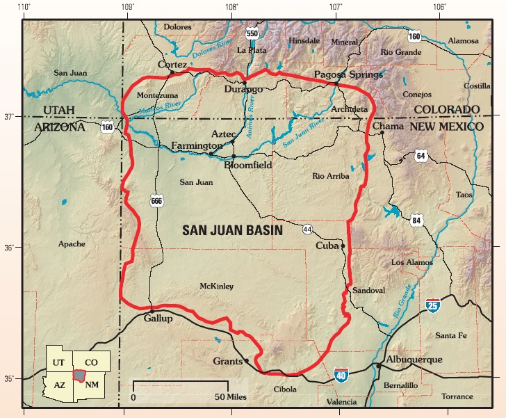
The San Juan Basin is a geologic structural basin located near the Four Corners region of the Southwestern United States. The basin covers 7,500 square miles and resides in northwestern New Mexico, southwestern Colorado, and parts of Utah and Arizona. Specifically, the basin occupies space in the San Juan, Rio Arriba, Sandoval, and McKinley counties in New Mexico, and La Plata and Archuleta counties in Colorado. The basin extends roughly N-S and E-W. The San Juan Basin is an asymmetric structural depression in the Colorado Plateau province, with varying elevation and nearly in topographic relief. Its most striking features include Chaco Canyon (northwestern New Mexico, between Farmington and Santa Fe) and Chacra Mesa. The basin lies west of the Continental Divide, and its main drainage is the southwest- to west-flowing San Juan River, which eventually joins the Colorado River in Utah. Climate of the basin is arid to semiarid, with an annual precipitation of and an a ... [...More Info...] [...Related Items...] OR: [Wikipedia] [Google] [Baidu] |
Hayden Survey
Ferdinand Vandeveer Hayden (September 7, 1829 – December 22, 1887) was an American geologist noted for his pioneering surveying expeditions of the Rocky Mountains in the late 19th century. He was also a physician who served with the Union Army during the Civil War. Early life Ferdinand Hayden was born in Westfield, Massachusetts. As a young boy he was fascinated with all nature and wildlife, which led him into the field of medicine. He worked in Cleveland under Jared Potter Kirtland and thereafter in Albany, NY, where he worked under James Hall, of the ''Geological Survey of New York''. He graduated from Oberlin College in 1850 and from the Albany Medical College in 1853, where he attracted the notice of Professor James Hall, state geologist of New York, through whose influence he was induced to join in an exploration of Nebraska Territory, with Fielding B. Meek to study geology and collect fossils. Hall sent him on his first geological venture in the summer of 1853. ... [...More Info...] [...Related Items...] OR: [Wikipedia] [Google] [Baidu] |
