|
Mentang
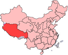
Mentang Raktsek (མན་ཐང་རགས་རྩེག་, ''Mendang-xiang'' 门当乡) is a 乡, township in Baingoin County, Tibet Autonomous Region, People's Republic of China. The township is situated on an elevation of 4,617 metres (15,148 ft.) and rests in the south west part of China. Neighboring locations consist of Lhasa, Shannan, and Xigatse, which all remain in the southwest part of China. See also *List of towns and villages in Tibet References Populated places in Nagqu Township-level divisions of Tibet {{Tibet-geo-stub ... [...More Info...] [...Related Items...] OR: [Wikipedia] [Google] [Baidu] |
Baingoin County
Baingoin County (; ) is a county within Nagqu of the Tibet Autonomous Region. County got the name from the lake Drang-khog () which is in center of county. County lies between lakes Namtso and Siling. The county is divided into ten towns and townships: * Pubao Town (, ''Pubao-zhen'' ) * Baoji Township (, ''Baoji-xiang'' ) * Beila Town (, ''Beila-zhen'' ) * Jiaqiong Town (, ''Jiaqiong-zhen'' ) * Dechen Town (, ''Deqing-zhen'' ) * Maqian Township (, ''Maqian-xiang'' ) * Mentang Raktsek Township (, ''Mendang-xiang'' ) * Qinglong Township (, ''Qinglong-xiang'' ) * Xênkyêr Township (, ''Xinjixiang'' ) * Nyima Township (, ''Nima-xiang'' ) Climate References Counties of Tibet Nagqu {{Nagqu-geo-stub ... [...More Info...] [...Related Items...] OR: [Wikipedia] [Google] [Baidu] |
List Of Towns And Villages In Tibet
This is an alphabetical list of all populated places, including cities, towns and villages, in the Tibet Autonomous Region of western China. A *Alamdo *Alhar *Arza *Asog B * Baga *Bagar * Baidi *Baima *Baimai *Baixoi *Bamda *Banag *Banbar *Banggaidoi *Bangkor *Bangru * Bangxing * Baqên *Bar *Bêba *Bei *Bênqungdo *Bilung *Birba * Biru *Bogkamba *Boindoi * Bolo *Bongba *Boqê *Bumgyê *Bungona’og * Bünsum * Burang *Bushêngcaka C * Caina *Cakaxiang *Camco *Cawarong * Cazê *Cêgnê *Cêngdo *Cêri *Cêrwai *Chabug *Chacang *Chagla * Chagna *Chagyoi *Cha’gyüngoinba *Chalükong *Chamco *Chamda *Chamoling *Changgo *Changlung *Changmar *Charing *Chatang *Chawola *Chêcang *Chênggo *Chepzi *Chibma *Chido *Chigu *Chongkü *Chongsar *Chowa *Chubalung *Chubarong *Chuka *Chumba *Chumbu *Chunduixiang *Co Nyi *Cocholung * Codoi *Cogo * Coka *Comai *Cona (Tsona) *Co’nga *Congdü *Conggo * Coqên *Coyang * Cuoma *Cuozheqiangma D *Dagdong *Dagmo *Dagri *Dagring *Dagzhuka ... [...More Info...] [...Related Items...] OR: [Wikipedia] [Google] [Baidu] |
Tibet Autonomous Region
The Tibet Autonomous Region or Xizang Autonomous Region, often shortened to Tibet or Xizang, is a province-level autonomous region of the People's Republic of China in Southwest China. It was overlayed on the traditional Tibetan regions of Ü-Tsang and Kham. It was formally established in 1965 to replace the Tibet Area, the former administrative division of the People's Republic of China (PRC) established after the annexation of Tibet. The establishment was about five years after the 1959 Tibetan uprising and the dismissal of the Kashag, and about 13 years after the original annexation. The current borders of the Tibet Autonomous Region were generally established in the 18th century and include about half of historic Tibet, or the ethno-cultural Tibet. The Tibet Autonomous Region spans over and is the second-largest province-level division of China by area, after Xinjiang. Due to its harsh and rugged terrain, it is sparsely populated at just over 3.6 million people ... [...More Info...] [...Related Items...] OR: [Wikipedia] [Google] [Baidu] |
People's Republic Of China
China, officially the People's Republic of China (PRC), is a country in East Asia. It is the world's List of countries and dependencies by population, most populous country, with a Population of China, population exceeding 1.4 billion, slightly ahead of India. China spans the equivalent of five time zones and Borders of China, borders fourteen countries by land, the List of countries and territories by land borders, most of any country in the world, tied with Russia. Covering an area of approximately , it is the world's third List of countries and dependencies by area, largest country by total land area. The country consists of 22 provinces of China, provinces, five autonomous regions of China, autonomous regions, four direct-administered municipalities of China, municipalities, and two special administrative regions of China, Special Administrative Regions (Hong Kong and Macau). The national capital is Beijing, and the List of cities in China by population, most populous ci ... [...More Info...] [...Related Items...] OR: [Wikipedia] [Google] [Baidu] |
Populated Places In Nagqu
Population typically refers to the number of people in a single area, whether it be a city or town, region, country, continent, or the world. Governments typically quantify the size of the resident population within their jurisdiction using a census, a process of collecting, analysing, compiling, and publishing data regarding a population. Perspectives of various disciplines Social sciences In sociology and population geography, population refers to a group of human beings with some predefined criterion in common, such as location, race, ethnicity, nationality, or religion. Demography is a social science which entails the statistical study of populations. Ecology In ecology, a population is a group of organisms of the same species who inhabit the same particular geographical area and are capable of interbreeding. The area of a sexual population is the area where inter-breeding is possible between any pair within the area and more probable than cross-breeding with ... [...More Info...] [...Related Items...] OR: [Wikipedia] [Google] [Baidu] |


