|
Meitetsu Kōwa Line
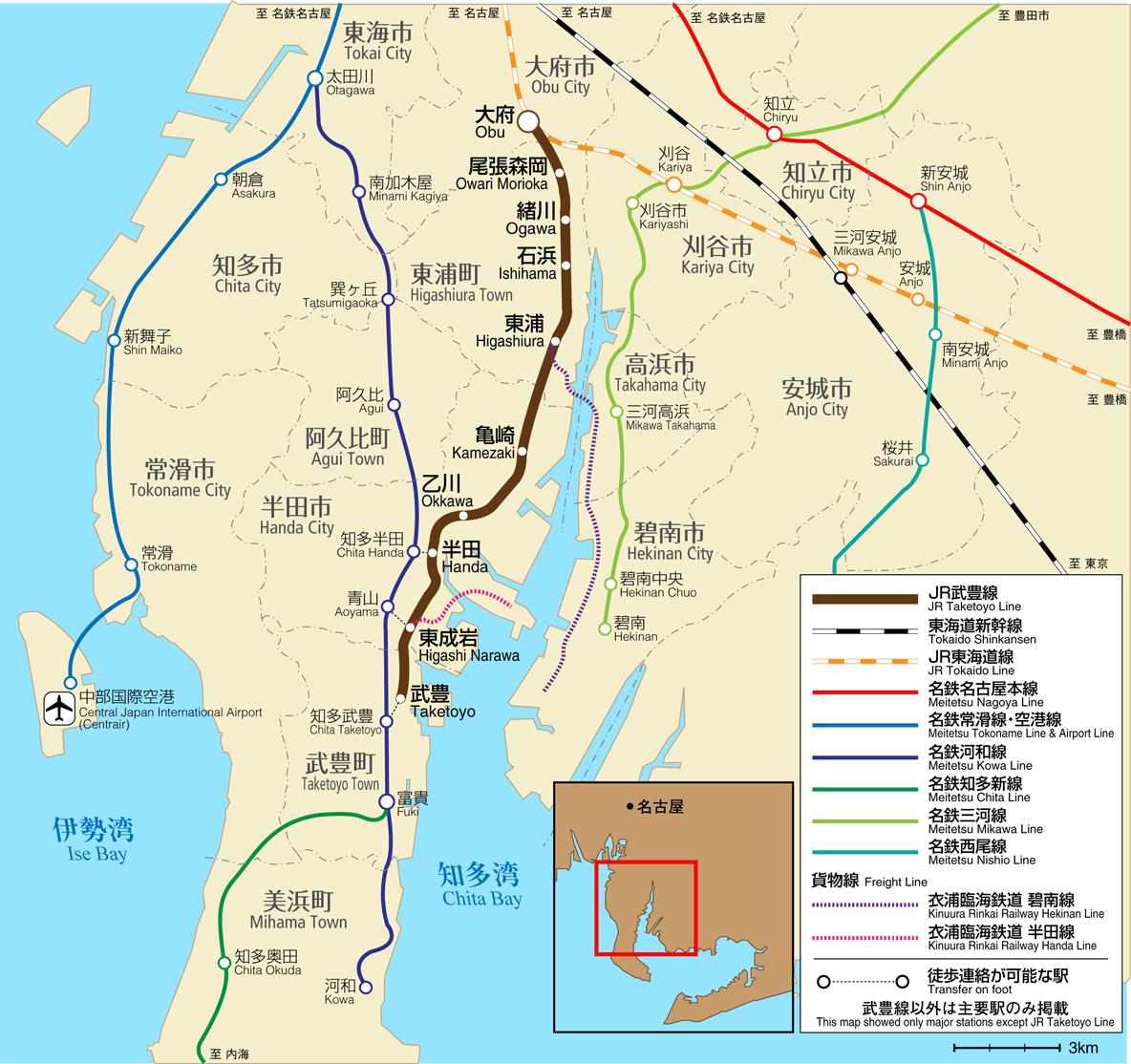
The is a Japanese railway line connecting Tōkai with Mihama within Aichi Prefecture. It is owned and operated by Meitetsu , referred to as , is a private railway company operating around Aichi Prefecture and Gifu Prefecture of Japan. Some of the more famous trains operated by Meitetsu include the ''Panorama Car'' and the '' Panorama Car Super'', both of which of .... History The Chita Electric Railway Co. opened the Otagawa - Kowaguchi section for passenger services, electrified at 1500 V DC, in 1931/32. Freight services commenced in 1933, and in 1935 the line was extended to Kowa. The company merged with Meitetsu in 1943, and the section from Otagawa to Kowaguchi was duplicated between 1960 and 1974. Panorama Super runs on only holidays. Future plans Kagiya-nakaoike Station is a new station that will be built between Takayokosuka and Minami Kagiya. It is due to open by the end of 2023. Stations References External links Official website (in Japanese) {{ ... [...More Info...] [...Related Items...] OR: [Wikipedia] [Google] [Baidu] |
Chita Peninsula
Chita Peninsula (知多半島 ''Chita Hantō'') is a peninsula to the south of Aichi Prefecture, central Honshū, Japan. It runs approximately north-south. To the west is Ise Bay, while to the east it encloses Mikawa Bay. It faces the Atsumi Peninsula southeast across Mikawa Bay. Chūbu Centrair International Airport is an international airport on an artificial island in Ise Bay, Tokoname City in Aichi Prefecture, south of Nagoya in central Japan. Centrair is classified as a first class airport and is the main international gateway for the Chubu ("ce ... is located off the west coast of the peninsula. External links (Hazumisaki:Southernmost point) Peninsulas of Japan Landforms of Aichi Prefecture {{Aichi-geo-stub ... [...More Info...] [...Related Items...] OR: [Wikipedia] [Google] [Baidu] |
Taketoyo Line
The is a Japanese railway line which connects Ōbu Station in Ōbu, Aichi Prefecture with Taketoyo Station in Taketoyo, Aichi Prefecture. It is owned and run by Central Japan Railway Company (JR Central). The line has been electrified as of 1 March 2015. Stations Rolling stock , 313 series electric multiple unit (EMU) trains are used in two- and four-car formations as well as 311 series EMUs in four-car formations. File:JR-Series311-G5 Special-Rapid.jpg, A 311 series EMU Prior to electrification of the line in March 2015, two-car KiHa 75 diesel multiple unit (DMU) and two-car KiHa 25 The is a diesel multiple unit (DMU) train type operated by the Central Japan Railway Company (JR Central) on local and rapid services in Japan, since March 2011. Following electrification of the Taketoyo Line in 2015, they replaced KiHa 40 seri ... DMU trains were used on this line in two- or four-car formations. History The entire line opened in 1886, becoming a branch when the Obu ... [...More Info...] [...Related Items...] OR: [Wikipedia] [Google] [Baidu] |
Handa, Aichi
is a city located in Aichi Prefecture, Japan. , the city had an estimated population of 118,259 in 51,846 households, and a population density of 2,494 persons per km2. The total area of the city was . Geography Handa is located in northeastern Chita Peninsula in southern Aichi Prefecture, and is bordered by Mikawa Bay to the east. Climate The city has a climate characterized by hot and humid summers, and relatively mild winters (Köppen climate classification ''Cfa''). The average annual temperature in Handa is 15.6 °C. The average annual rainfall is 1632 mm with September as the wettest month. The temperatures are highest on average in August, at around 27.5 °C, and lowest in January, at around 4.5 °C. Demographics Per Japanese census data, the population of Handa has increased steadily over the past 70 years. Neighboring municipalities ; Aichi Prefecture *Hekinan *Tokoname * Takahama * Taketoyo *Agui * Higashiura History Early modern period During t ... [...More Info...] [...Related Items...] OR: [Wikipedia] [Google] [Baidu] |
Chita District, Aichi
is a rural district located in southwestern Aichi Prefecture, Japan, on Chita Peninsula. As of 1 October 2019, the district had an estimated population of 160,542 and a population density of 968 persons per km2. Its total area was 165.84 km2. Towns There are currently five towns within the district. *Agui * Higashiura * Mihama * Minamichita * Taketoyo History Chita District was one of the ancient districts of Owari Province and is mentioned in Nara period records. One of the castles that guarded the area was Ōno Castle. Modern Chita District dates to the cadastral reforms of the early Meiji period, and was initially given to Nukata Prefecture in former Mikawa Province, whereas the holdings of former Owari Domain became ''Nagoya Prefecture''. With the creation of Aichi Prefecture, Chita District again came to be considered part of former Owari Province. With the organization of municipalities on October 1, 1889, Chita District was divided into four towns (Handa, Kamez ... [...More Info...] [...Related Items...] OR: [Wikipedia] [Google] [Baidu] |
Agui, Aichi
is a town located in Chita District, Aichi Prefecture, Japan. , the town had an estimated population of 28,291 in 10,682 households, and a population density of 1,189 persons per km². The total area of the town was . Geography Agui is located in an inland area of northwestern Chita Peninsula in southern Aichi Prefecture. It is located approximately 30 minutes by car or express train from downtown Nagoya. The highest elevation is 74.7 meters above sea level. Neighboring municipalities Aichi Prefecture * Higashiura *Tokoname * Chita * Handa Demographics Per Japanese census data, the population of Agui has been relatively steady over the past 50 years. Climate The town has a climate characterized by hot and humid summers, and relatively mild winters (Köppen climate classification ''Cfa''). The average annual temperature in Agui is 15.5 °C. History The name of Agui is very ancient, and appears in Asuka and Nara period records. During the Muromachi period, the area was ... [...More Info...] [...Related Items...] OR: [Wikipedia] [Google] [Baidu] |

