|
Maybole Town Hall
Maybole Town Hall is a municipal structure in the High Street in Maybole, South Ayrshire, Scotland. The structure, which is used as a community events venue, is a Category B listed building. History The oldest part of the complex is the tower which formed part of house known as Blairquhanes Place. The house was designed in the Scottish medieval style, built in rubble masonry and dated back to the 16th century. The tower was originally surmounted by a balustrade and a pyramid-shaped roof with a clock. Internally, there was a lock up on the ground floor and a courtroom on the first floor. In October 1674, John Kennedy, 7th Earl of Cassilis, acquired the house, demolished much of the original structure, and converted the tower for use as a tolbooth: further repairs were commissioned by Archibald Kennedy, 11th Earl of Cassilis in the late 18th century, and the tower was crenelated in 1812. The building was substantially extended to the northeast in the Scottish baronial style to a ... [...More Info...] [...Related Items...] OR: [Wikipedia] [Google] [Baidu] |
Maybole
Maybole is a town and former burgh of barony and police burgh in South Ayrshire, Scotland. It had an estimated population of in . It is situated south of Ayr and southwest of Glasgow by the Glasgow and South Western Railway. The town is bypassed by the A77 road, A77. History Maybole has Middle Ages roots, receiving a charter from Donnchadh, Earl of Carrick in 1193. In 1516 it was made a burgh of regality, although for generations it remained under the suzerainty of the Kennedy clan, Kennedys, afterwards Earl of Cassillis, Earls of Cassillis and (later) Marquess of Ailsa, Marquesses of Ailsa, the most powerful family in Ayrshire. The Archibald Angus Charles Kennedy, 8th Marquess of Ailsa, Marquess of Ailsa lived at Cassillis House, just outside Maybole until its sale in 2007. In the late seventeenth century, a census recorded Maybole was home to 28 "lords and landowners with estates in Carrick and beyond." In former times, Maybole was the capital of the district of Carr ... [...More Info...] [...Related Items...] OR: [Wikipedia] [Google] [Baidu] |
Balcony
A balcony (from it, balcone, "scaffold") is a platform projecting from the wall of a building, supported by columns or console brackets, and enclosed with a balustrade, usually above the ground floor. Types The traditional Maltese balcony is a wooden closed balcony projecting from a wall. By contrast, a Juliet balcony does not protrude out of the building. It is usually part of an upper floor, with a balustrade only at the front, like a small loggia. A modern Juliet balcony often involves a metal barrier placed in front of a high window that can be opened. In the UK, the technical name for one of these was officially changed in August 2020 to a ''Juliet guarding''. Juliet balconies are named after William Shakespeare's Juliet, who, in traditional stagings of the play ''Romeo and Juliet'', is courted by Romeo while she is on her balcony—though the play itself, as written, makes no mention of a balcony, but only of a window at which Juliet appears. Various types of balcony ha ... [...More Info...] [...Related Items...] OR: [Wikipedia] [Google] [Baidu] |
Government Buildings Completed In 1887
A government is the system or group of people governing an organized community, generally a state. In the case of its broad associative definition, government normally consists of legislature, executive, and judiciary. Government is a means by which organizational policies are enforced, as well as a mechanism for determining policy. In many countries, the government has a kind of constitution, a statement of its governing principles and philosophy. While all types of organizations have governance, the term ''government'' is often used more specifically to refer to the approximately 200 independent national governments and subsidiary organizations. The major types of political systems in the modern era are democracies, monarchies, and authoritarian and totalitarian regimes. Historically prevalent forms of government include monarchy, aristocracy, timocracy, oligarchy, democracy, theocracy, and tyranny. These forms are not always mutually exclusive, and mixed governme ... [...More Info...] [...Related Items...] OR: [Wikipedia] [Google] [Baidu] |
List Of Listed Buildings In Maybole, South Ayrshire
This is a list of listed buildings in the parish of Maybole in South Ayrshire, Scotland. List Key Notes References * All entries, addresses and coordinates are based on data froHistoric Scotland This data falls under thOpen Government Licence {{Lists of listed buildings in South Ayrshire Maybole Maybole is a town and former burgh of barony and police burgh in South Ayrshire, Scotland. It had an estimated population of in . It is situated south of Ayr and southwest of Glasgow by the Glasgow and South Western Railway. The town is bypass ... Maybole ... [...More Info...] [...Related Items...] OR: [Wikipedia] [Google] [Baidu] |
South Ayrshire Council
South is one of the cardinal directions or compass points. The direction is the opposite of north and is perpendicular to both east and west. Etymology The word ''south'' comes from Old English ''sūþ'', from earlier Proto-Germanic ''*sunþaz'' ("south"), possibly related to the same Proto-Indo-European root that the word ''sun'' derived from. Some languages describe south in the same way, from the fact that it is the direction of the sun at noon (in the Northern Hemisphere), like Latin meridies 'noon, south' (from medius 'middle' + dies 'day', cf English meridional), while others describe south as the right-hand side of the rising sun, like Biblical Hebrew תֵּימָן teiman 'south' from יָמִין yamin 'right', Aramaic תַּימנַא taymna from יָמִין yamin 'right' and Syriac ܬܰܝܡܢܳܐ taymna from ܝܰܡܝܺܢܳܐ yamina (hence the name of Yemen, the land to the south/right of the Levant). Navigation By convention, the ''bottom or down-facing side'' of ... [...More Info...] [...Related Items...] OR: [Wikipedia] [Google] [Baidu] |
Historic Environment Scotland
Historic Environment Scotland (HES) ( gd, Àrainneachd Eachdraidheil Alba) is an executive non-departmental public body responsible for investigating, caring for and promoting Scotland's historic environment. HES was formed in 2015 from the merger of government agency Historic Scotland with the Royal Commission on the Ancient and Historical Monuments of Scotland (RCAHMS). Among other duties, Historic Environment Scotland maintains more than 300 properties of national importance including Edinburgh Castle, Skara Brae and Fort George. History The responsibilities of HES were formerly split between Historic Scotland, a government agency responsible for properties of national importance, and the Royal Commission on the Ancient and Historical Monuments of Scotland (RCAHMS), which collected and managed records about Scotland's historic environment. Under the terms of a Bill of the Scottish Parliament published on 3 March 2014, the pair were dissolved and their functions transferred ... [...More Info...] [...Related Items...] OR: [Wikipedia] [Google] [Baidu] |
National Lottery Heritage Fund
The National Lottery Heritage Fund, formerly the Heritage Lottery Fund (HLF), distributes a share of National Lottery funding, supporting a wide range of heritage projects across the United Kingdom. History The fund's predecessor bodies were the National Land Fund, established in 1946, and the National Heritage Memorial Fund, established in 1980. The current body was established as the "Heritage Lottery Fund" in 1994. It was re-branded as the National Lottery Heritage Fund in January 2019. Activities The fund's income comes from the National Lottery which is managed by Camelot Group. Its objectives are "to conserve the UK's diverse heritage, to encourage people to be involved in heritage and to widen access and learning". As of 2019, it had awarded £7.9 billion to 43,000 projects. In 2006, the National Lottery Heritage Fund launched the Parks for People program with the aim to revitalize historic parks and cemeteries. From 2006 to 2021, the Fund had granted £254million ... [...More Info...] [...Related Items...] OR: [Wikipedia] [Google] [Baidu] |
Kyle And Carrick
Kyle and Carrick ( gd, A' Chùil agus a' Charraig) was one of nineteen local government districts in the Strathclyde region of Scotland from 1975 to 1996. History The district was formed by the Local Government (Scotland) Act 1973 from part of the former county of Ayrshire, namely: *The burghs of Ayr, Girvan, Maybole, Prestwick and Troon *The districts of Girvan and Maybole *The district of Ayr (except the part in Irvine New Town) *Part of Dalmellington district The district council's headquarters were in Ayr, where they established offices in Burns House in Burns Statue Square with a satellite office in a two storey, 19th century villa at 30 Miller Road. The district bordered districts of Cunninghame, Kilmarnock & Loudoun and Cumnock and Doon Valley Districts of Strathclyde to its north and east as well as Stewartry and Wigtown Districts in Dumfries & Galloway. In 1974 Alistair Irving Haughan was appointed Chief Architect of Kyle & Carrick District Council, holding the ... [...More Info...] [...Related Items...] OR: [Wikipedia] [Google] [Baidu] |
Cone
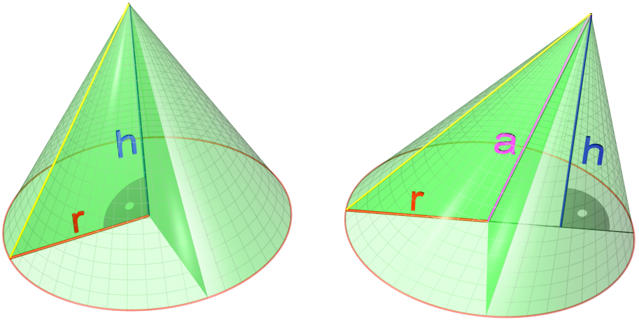
A cone is a three-dimensional geometric shape that tapers smoothly from a flat base (frequently, though not necessarily, circular) to a point called the apex or vertex. A cone is formed by a set of line segments, half-lines, or lines connecting a common point, the apex, to all of the points on a base that is in a plane that does not contain the apex. Depending on the author, the base may be restricted to be a circle, any one-dimensional quadratic form in the plane, any closed one-dimensional figure, or any of the above plus all the enclosed points. If the enclosed points are included in the base, the cone is a solid object; otherwise it is a two-dimensional object in three-dimensional space. In the case of a solid object, the boundary formed by these lines or partial lines is called the ''lateral surface''; if the lateral surface is unbounded, it is a conical surface. In the case of line segments, the cone does not extend beyond the base, while in the case of half-lin ... [...More Info...] [...Related Items...] OR: [Wikipedia] [Google] [Baidu] |
Bartizan
A bartizan (an alteration of ''bratticing''), also called a guerite, ''garita'', or ''échauguette'', or spelled bartisan, is an overhanging, wall-mounted turret projecting from the walls of late medieval and early-modern fortifications from the early 14th century up to the 18th century. Most frequently found at corners, they protected a warder and enabled him to see his surroundings. Bartizans generally are furnished with oillets or arrow slits. The turret was usually supported by stepped masonry corbels and could be round, polygonal or square. Bartizans were incorporated into many notable examples of Scottish Baronial architecture. In the architecture of Aberdeen, the new Town House, built in 1868–74, incorporates bartizans in the West Tower. Gallery At walls File:Round Bartizan, Fortaleza de Santiago, Sesimbra, Portugal.JPG, ''Guarita'' at Fortaleza de Santiago, Sesimbra Municipality, Portugal. File:Sudika Isla watchtower.jpg, ''Gardjola'' at the Spur, Senglea, Malt ... [...More Info...] [...Related Items...] OR: [Wikipedia] [Google] [Baidu] |
Stepped Gable
A stepped gable, crow-stepped gable, or corbie step is a stairstep type of design at the top of the triangular gable-end of a building. The top of the parapet wall projects above the roofline and the top of the brick or stone wall is stacked in a step pattern above the roof as a decoration and as a convenient way to finish the brick courses. A stepped parapet may appear on building facades with or without gable ends, even upon a false front, however. Geography The oldest examples can be seen in Ghent (Flanders, Belgium) and date from the 12th century: the house called ''Spijker'' on ''Graslei'', and some other Romanesque buildings in this city. From there, they were spread in the whole of Northern Europe as from the 13th century, in particular in cities of the Hanseatic League (with brick Gothic style), then in Central Europe at the next century. These gables are numerous in Belgium, Netherlands, all Germany, Denmark, Sweden, Poland, Baltic States, Switzerland, and some parts ... [...More Info...] [...Related Items...] OR: [Wikipedia] [Google] [Baidu] |


.jpg)
