|
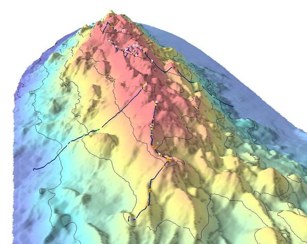
Maud Seamount
Maud Seamount () is a seamount in the Southern Ocean. Its name was approved by the Advisory Committee for Undersea Features The United States Board on Geographic Names (BGN) is a federal body operating under the United States Secretary of the Interior. The purpose of the board is to establish and maintain uniform usage of geographic names throughout the federal governm ... in February 1964. References Seamounts of the Southern Ocean Landforms of Queen Maud Land {{marine-geo-stub ... [...More Info...] [...Related Items...] OR: [Wikipedia] [Google] [Baidu] |
Seamount
A seamount is a large geologic landform that rises from the ocean floor that does not reach to the water's surface (sea level), and thus is not an island, islet or cliff-rock. Seamounts are typically formed from extinct volcanoes that rise abruptly and are usually found rising from the seafloor to in height. They are defined by oceanographers as independent features that rise to at least above the seafloor, characteristically of conical form.IHO, 2008. Standardization of Undersea Feature Names: Guidelines Proposal form Terminology, 4th ed. International Hydrographic Organization and Intergovernmental Oceanographic Commission, Monaco. The peaks are often found hundreds to thousands of meters below the surface, and are therefore considered to be within the deep sea. During their evolution over geologic time, the largest seamounts may reach the sea surface where wave action erodes the summit to form a flat surface. After they have subsided and sunk below the sea surface such flat ... [...More Info...] [...Related Items...] OR: [Wikipedia] [Google] [Baidu] |
Southern Ocean
The Southern Ocean, also known as the Antarctic Ocean, comprises the southernmost waters of the World Ocean, generally taken to be south of 60° S latitude and encircling Antarctica. With a size of , it is regarded as the second-smallest of the five principal oceanic divisions: smaller than the Pacific, Atlantic, and Indian oceans but larger than the Arctic Ocean. Over the past 30 years, the Southern Ocean has been subject to rapid climate change, which has led to changes in the marine ecosystem. By way of his voyages in the 1770s, James Cook proved that waters encompassed the southern latitudes of the globe. Since then, geographers have disagreed on the Southern Ocean's northern boundary or even existence, considering the waters as various parts of the Pacific, Atlantic, and Indian oceans, instead. However, according to Commodore John Leech of the International Hydrographic Organization (IHO), recent oceanographic research has discovered the importance of Southern ... [...More Info...] [...Related Items...] OR: [Wikipedia] [Google] [Baidu] |
Advisory Committee For Undersea Features
The United States Board on Geographic Names (BGN) is a federal body operating under the United States Secretary of the Interior. The purpose of the board is to establish and maintain uniform usage of geographic names throughout the federal government of the United States. History On January 8, 1890, Thomas Corwin Mendenhall, superintendent of the US Coast and Geodetic Survey Office, wrote to 10 noted geographers "to suggest the organization of a Board made up of representatives from the different Government services interested, to which may be referred any disputed question of geographical orthography." President Benjamin Harrison signed executive order 28 on September 4, 1890, establishing the ''Board on Geographical Names''. "To this Board shall be referred all unsettled questions concerning geographic names. The decisions of the Board are to be accepted y federal departmentsas the standard authority for such matters." The board was given authority to resolve all unsettled quest ... [...More Info...] [...Related Items...] OR: [Wikipedia] [Google] [Baidu] |
Seamounts Of The Southern Ocean
A seamount is a large geologic landform that rises from the ocean floor that does not reach to the water's surface (sea level), and thus is not an island, islet or cliff-rock. Seamounts are typically formed from extinct volcanoes that rise abruptly and are usually found rising from the seafloor to in height. They are defined by oceanographers as independent features that rise to at least above the seafloor, characteristically of conical form.IHO, 2008. Standardization of Undersea Feature Names: Guidelines Proposal form Terminology, 4th ed. International Hydrographic Organization and Intergovernmental Oceanographic Commission, Monaco. The peaks are often found hundreds to thousands of meters below the surface, and are therefore considered to be within the deep sea. During their evolution over geologic time, the largest seamounts may reach the sea surface where wave action erodes the summit to form a flat surface. After they have subsided and sunk below the sea surface such ... [...More Info...] [...Related Items...] OR: [Wikipedia] [Google] [Baidu] |

