|
Marycliff-Cliff Park Historic District
The Marycliff-Cliff Park Historic District is a historic residential area in the Cliff/Cannon, Spokane, Cliff/Cannon neighborhood of Spokane, Washington, located immediately uphill from the city's Downtown Spokane, downtown core, listed on the National Register of Historic Places (NRHP). The district is made up of two distinct but connected areas, the Marycliff section located at the base of a basalt cliff and south of Seventh Avenue, and the Cliff Park section located atop the cliff and north of 14th Avenue. Encroachment from the nearby city center has changed the nature of the Marycliff section over the decades. Of the palatial homes built in the late 1800s in the area, all have either been converted to commercial or public use or razed to make way for new development, though there are still a number of properties that are intact and reflect the historic nature of the area. The Cliff Park section retains its original residential character and historic nature, with only 11 propert ... [...More Info...] [...Related Items...] OR: [Wikipedia] [Google] [Baidu] |
Cliff/Cannon, Spokane
Cliff/Cannon is a neighborhood in Spokane, Washington. It is located immediately south of Downtown, Spokane, and on the lower reaches of the broader South Hill. The neighborhood is home to a medical district with Sacred Heart and Deaconess both having their main hospital campuses along Cliff/Cannon's denser northern edge. To the south the neighborhood becomes more residential. City parks break up the residential zoning of the southern half of Cliff/Cannon. It is adjacent to the Cannon Hill area of the neighboring but separate Manito/Cannon Hill neighborhood. The Marycliff-Cliff Park Historic District, a National Historic District listed on the National Register of Historic Places, is located within the neighborhood. Geography Cliff/Cannon is a neighborhood in Spokane located on the south side of the city. Cliff/Cannon is located directly between the central business district and the more suburban, residential South Hill. There is a large medical campus in the northern po ... [...More Info...] [...Related Items...] OR: [Wikipedia] [Google] [Baidu] |
Neighborhoods In Spokane, Washington
Neighborhoods in Spokane, Washington are officially grouped by the Spokane City Council into three main city council districts: 1, 2, and 3. Each city council district contains multiple, official neighborhoods that are recognized with a neighborhood council. Informally, neighborhoods are colloquially grouped by local geographical, geological, cultural, or historical features (such as South Hill, North Side, Five Mile, Hillyard, South Perry, etc.) The list of neighborhoods below is organized based on the official designations by the City of Spokane. Unofficial neighborhoods and districts are listed within the official neighborhood in which they are located. Neighborhoods in Spokane range from the late Victorian-era to the contemporary. With major peopling coming from the city's origins as a major rail center in the early 20th century, before the automobile, this has had an indelible impact on the urban form and character of Spokane and its neighborhoods. As the primary mode o ... [...More Info...] [...Related Items...] OR: [Wikipedia] [Google] [Baidu] |
James N
James is a common English language surname and given name: *James (name), the typically masculine first name James * James (surname), various people with the last name James James or James City may also refer to: People * King James (other), various kings named James * Saint James (other) * James (musician) * James, brother of Jesus Places Canada * James Bay, a large body of water * James, Ontario United Kingdom * James College, a college of the University of York United States * James, Georgia, an unincorporated community * James, Iowa, an unincorporated community * James City, North Carolina * James City County, Virginia ** James City (Virginia Company) ** James City Shire * James City, Pennsylvania * St. James City, Florida Arts, entertainment, and media * ''James'' (2005 film), a Bollywood film * ''James'' (2008 film), an Irish short film * ''James'' (2022 film), an Indian Kannada-language film * James the Red Engine, a character in ''Thomas the Tank En ... [...More Info...] [...Related Items...] OR: [Wikipedia] [Google] [Baidu] |
Eastern State Hospital (Washington)
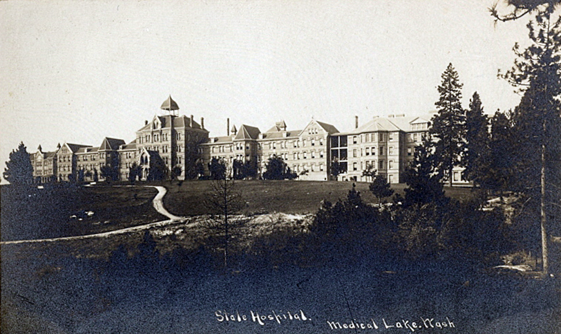
Eastern State Hospital is a psychiatric hospital established in 1891 in Medical Lake, a small community southwest of Spokane, Washington. The original building was a Kirkbride Plan and the current building has a similar floor plan with male and female wings extending out from the main building. A facility for the mentally ill in Washington State, it was commissioned by the Territorial Legislature in 1886 to ease overcrowding at Western State Hospital, which at the time was the only hospital for the mentally ill in the Washington Territory. Over the years, the hospital has been the subject of a number of scandals regarding the treatment of its patients and the quality and effectiveness of the care provided. As a result of these scandals, the vast increase in scientific and medical understanding of mental illnesses and the methodologies of effective treatment thereof, the hospital has undergone numerous transitions in the past century. The hospital continues to operate today as ... [...More Info...] [...Related Items...] OR: [Wikipedia] [Google] [Baidu] |
Sweden
Sweden, formally the Kingdom of Sweden,The United Nations Group of Experts on Geographical Names states that the country's formal name is the Kingdom of SwedenUNGEGN World Geographical Names, Sweden./ref> is a Nordic country located on the Scandinavian Peninsula in Northern Europe. It borders Norway to the west and north, Finland to the east, and is connected to Denmark in the southwest by a bridgetunnel across the Öresund. At , Sweden is the largest Nordic country, the third-largest country in the European Union, and the fifth-largest country in Europe. The capital and largest city is Stockholm. Sweden has a total population of 10.5 million, and a low population density of , with around 87% of Swedes residing in urban areas in the central and southern half of the country. Sweden has a nature dominated by forests and a large amount of lakes, including some of the largest in Europe. Many long rivers run from the Scandes range through the landscape, primarily ... [...More Info...] [...Related Items...] OR: [Wikipedia] [Google] [Baidu] |
British Columbia
British Columbia (commonly abbreviated as BC) is the westernmost province of Canada, situated between the Pacific Ocean and the Rocky Mountains. It has a diverse geography, with rugged landscapes that include rocky coastlines, sandy beaches, forests, lakes, mountains, inland deserts and grassy plains, and borders the province of Alberta to the east and the Yukon and Northwest Territories to the north. With an estimated population of 5.3million as of 2022, it is Canada's third-most populous province. The capital of British Columbia is Victoria and its largest city is Vancouver. Vancouver is the third-largest metropolitan area in Canada; the 2021 census recorded 2.6million people in Metro Vancouver. The first known human inhabitants of the area settled in British Columbia at least 10,000 years ago. Such groups include the Coast Salish, Tsilhqotʼin, and Haida peoples, among many others. One of the earliest British settlements in the area was Fort Victoria, established ... [...More Info...] [...Related Items...] OR: [Wikipedia] [Google] [Baidu] |
Kootenays
The Kootenays or Kootenay ( ) is a region of southeastern British Columbia. It takes its name from the Kootenay River, which in turn was named for the Kutenai First Nations people. Boundaries The Kootenays are more or less defined by the Kootenay Land District, though some variation exists in terms of what areas are or are not a part. The strictest definition of the region is the drainage basin of the lower Kootenay River from its re-entry into Canada near Creston, through to its confluence with the Columbia at Castlegar ''(illustrated by a, right)''. In most interpretations, however, the region also includes: * an area to the east which encompasses the upper drainage basin of the Kootenay River from its rise in the Rocky Mountains to its passage into the United States at Newgate. This adds a region spanning from the Purcell Mountains to the Alberta border, and includes Rocky Mountain Trench cities such as Cranbrook and Kimberley and the Elk Valley of the southern Canadian ... [...More Info...] [...Related Items...] OR: [Wikipedia] [Google] [Baidu] |
North Idaho
The Idaho Panhandle—locally known as North Idaho—is a salient region of the U.S. state of Idaho encompassing the state's 10 northernmost counties: Benewah, Bonner, Boundary, Clearwater, Idaho, Kootenai, Latah, Lewis, Nez Perce, and Shoshone (though the southern part of the region is sometimes referred to as North Central Idaho). The Panhandle is bordered by the state of Washington to the west, Montana to the east, and the Canadian province of British Columbia to the north. The Idaho panhandle, along with Eastern Washington, makes up the region known as the Inland Northwest, headed by its largest city, Spokane, Washington. Coeur d'Alene is the largest city within the Idaho Panhandle. Spokane is around west of Coeur d'Alene, and its Spokane International Airport is the region's main air hub. Other important cities in the region include Lewiston, Moscow, Post Falls, Hayden, Sandpoint, and the smaller towns of St. Maries and Bonners Ferry. East of Coeur d'Alene is the ... [...More Info...] [...Related Items...] OR: [Wikipedia] [Google] [Baidu] |
Silver Valley, Idaho
The Silver Valley is a region in the northwest United States, in the Coeur d'Alene Mountains in northern Idaho. It is noted for its mining heritage, dating back to the 1880s. Geography Silver Valley is a narrow valley about in length, east of the city of Coeur d'Alene. The South Fork of the Coeur d'Alene River flows through the valley and Interstate 90 traverses the valley between Fourth of July Pass to the west and Lookout Pass on the Montana border. Several towns are located in the valley, all in Shoshone County. These include (from west to east) Pinehurst, Smelterville, Kellogg, Wardner, Osburn, Silverton, Wallace, and Mullan. The Silver Valley has also been referred to as the Coeur d'Alene Valley and the Coeur d'Alene Mining District. Geology The Coeur d'Alene (Silver Valley) Mining District is located in Proterozoic metasediments. The mined portion of the stratigraphic column in the Silver Valley, known as the Belt series, can be divided into six main for ... [...More Info...] [...Related Items...] OR: [Wikipedia] [Google] [Baidu] |
Balustrades
A baluster is an upright support, often a vertical moulded shaft, square, or lathe-turned form found in stairways, parapets, and other architectural features. In furniture construction it is known as a spindle. Common materials used in its construction are wood, stone, and less frequently metal and ceramic. A group of balusters supporting a handrail, coping, or ornamental detail are known as a balustrade. The term baluster shaft is used to describe forms such as a candlestick, upright furniture support, and the stem of a brass chandelier. The term banister (also bannister) refers to a baluster or to the system of balusters and handrail of a stairway. It may be used to include its supporting structures, such as a supporting newel post. Etymology According to the ''Oxford English Dictionary'', "baluster" is derived through the french: balustre, from it, balaustro, from ''balaustra'', "pomegranate flower" rom a resemblance to the swelling form of the half-open flower (''illust ... [...More Info...] [...Related Items...] OR: [Wikipedia] [Google] [Baidu] |
Colonial Revival
The Colonial Revival architectural style seeks to revive elements of American colonial architecture. The beginnings of the Colonial Revival style are often attributed to the Centennial Exhibition of 1876, which reawakened Americans to the architectural traditions of their colonial past. Fairly small numbers of Colonial Revival homes were built c. 1880–1910, a period when Queen Anne-style architecture was dominant in the United States. From 1910–1930, the Colonial Revival movement was ascendant, with about 40% of U.S. homes built during this period in the Colonial Revival style. In the immediate post-war period (c. 1950s–early 1960s), Colonial Revival homes continued to be constructed, but in simplified form. In the present-day, many New Traditional homes draw from Colonial Revival styles. While the dominant influences in Colonial Revival style are Georgian and Federal architecture, Colonial Revival homes also draw, to a lesser extent, from the Dutch Colonial ... [...More Info...] [...Related Items...] OR: [Wikipedia] [Google] [Baidu] |
Corbin Art Center
Corbin may refer to: People * Corbin (given name) * Corbin (surname) * Corbin (musician), American singer Buildings * Corbin Building, a historic building located at 192 Broadway in New York, US * Corbin Cabin, a log structure in Shenandoah National Park, US * Corbin Covered Bridge, a covered bridge in New Hampshire, US * Corbin, a variant of Corbenic, the Grail castle in Arthurian literature Places Canada * Corbin, British Columbia, a ghost town * Corbin, Burin Peninsula, Newfoundland and Labrador, a settlement * Corbin, Fortune Bay, Newfoundland and Labrador, a settlement United States * Corbin, Georgia, an unincorporated community * Corbin, Kansas, a community in Sumner County * Corbin, Kentucky, a city located in Whitley and Knox Counties * Corbin, Missouri, a ghost town * Corbin, Montana, an unincorporated community and ghost town in Jefferson County * Corbin, Virginia, an unincorporated community in Caroline County * Corbin, West Virginia, an unincorporated co ... [...More Info...] [...Related Items...] OR: [Wikipedia] [Google] [Baidu] |


