|
Martensøya
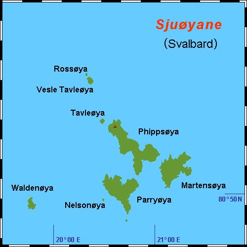
Martensøya (anglicized as Martens Island) is the easternmost island of Sjuøyane, which lies north of Nordaustlandet, part of the Svalbard archipelago in Arctic Norway. The island is named after the German physician Friderich Martens, who visited Spitsbergen Spitsbergen (; formerly known as West Spitsbergen; Norwegian: ''Vest Spitsbergen'' or ''Vestspitsbergen'' , also sometimes spelled Spitzbergen) is the largest and the only permanently populated island of the Svalbard archipelago in northern Norw ... in 1671. Total area 19 km2. Highest point: Sølvberget, 405 m.a.s.l.. References * Norwegian Polar InstitutePlace names in Norwegian polar areas Islands of Svalbard {{svalbard-geo-stub ... [...More Info...] [...Related Items...] OR: [Wikipedia] [Google] [Baidu] |
Friderich Martens
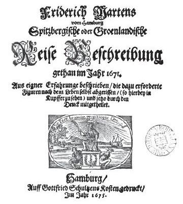
Friderich Martens (1635 - 1699) , Tjärnö Marine Biological Laboratory, Göteborg University International League of Antiquarian Booksellers (ILAB) was a German physician and naturalist who conducted the first scientific observations of the nature, animal life and climate of Svalbard. Government of Norway, document archives He published his notes in the book "''Spitzbergische oder Groenlandische Reise-Beschreibung, gethan im Jahre 1671''" and this book became a reference work for many decades. [...More Info...] [...Related Items...] OR: [Wikipedia] [Google] [Baidu] |
Sjuøyane
Sjuøyane (English: ''Seven Islands'') is the northernmost part of the Svalbard archipelago north of mainland Norway, and some 20 km north of the eastern major island Nordaustlandet. The islands are the northernmost landmass reachable by normal means, being 1024.3 kilometers (637 mi / 553 nm) south of the North Pole. In comparison, Robert Falcon Scott started his ill-fated Terra Nova Expedition 1374 km (742 Nm) from the South Pole. Many of the islands are named after English explorers, most notably Captain Nelson. Geography As the name implies, this is regarded as a group of seven islands (including several islets and skerries), of which the three larger ones are: *Phippsøya *Martensøya *Parryøya And the four smaller: *Nelsonøya *Waldenøya *Tavleøya *Vesle Tavleøya with Rossøya Rossøya, more a skerry than an island, is at 80°49’44" the northernmost land of Svalbard and thus of Norway. Ice conditions are often difficult, but they are often earlier accessib ... [...More Info...] [...Related Items...] OR: [Wikipedia] [Google] [Baidu] |
Anglicized
Anglicisation is the process by which a place or person becomes influenced by English culture or British culture, or a process of cultural and/or linguistic change in which something non-English becomes English. It can also refer to the influence of English culture and business on other countries outside England or the United Kingdom, including their media, cuisine, popular culture, technology, business practices, laws, or political systems. Linguistic anglicisation is the practice of modifying foreign words, names, and phrases to make them easier to spell, pronounce or understand in English. The term commonly refers to the respelling of foreign words, often to a more drastic degree than that implied in, for example, romanisation. One instance is the word "dandelion", modified from the French ''dent-de-lion'' ("lion's tooth", a reference to the plant's sharply indented leaves). The term can also refer to phonological adaptation without spelling change: ''spaghetti'', for example ... [...More Info...] [...Related Items...] OR: [Wikipedia] [Google] [Baidu] |
Nordaustlandet
Nordaustlandet (sometimes translated as North East Land) is the second-largest island in the archipelago of Svalbard, Norway, with an area of . It lies north east of Spitsbergen, separated by Hinlopen Strait. Much of Nordaustlandet lies under large ice caps, mainly Austfonna and Vestfonna, the remaining parts of the north being tundra inhabited by reindeer and walruses. The island is uninhabited and lies entirely within Nordaust-Svalbard Nature Reserve. History English walrus hunters first sighted the south point of Nordaustlandet in 1617. This discovery was shown on the ''Muscovy Company's map'' (1625; but based on discoveries made in and prior to 1622), with the island labeled as ''Sir Thomas Smyth's Iland''. It also shows the North Cape (''Point Purchas''). It is first named ''Oostlandt'' ("East Land") on a Dutch 1662 map, and the following year another Dutch map marked its coastline more distinctly, showing its west and north coasts, separating the latter from the Seven Isl ... [...More Info...] [...Related Items...] OR: [Wikipedia] [Google] [Baidu] |
Svalbard
Svalbard ( , ), also known as Spitsbergen, or Spitzbergen, is a Norwegian archipelago in the Arctic Ocean. North of mainland Europe, it is about midway between the northern coast of Norway and the North Pole. The islands of the group range from 74° to 81° north latitude, and from 10° to 35° east longitude. The largest island is Spitsbergen, followed by Nordaustlandet and . The largest settlement is Longyearbyen. The islands were first used as a base by the whalers who sailed far north in the 17th and 18th centuries, after which they were abandoned. Coal mining started at the beginning of the 20th century, and several permanent communities were established. The Svalbard Treaty of 1920 recognizes Norwegian sovereignty, and the 1925 Svalbard Act made Svalbard a full part of the Kingdom of Norway. They also established Svalbard as a free economic zone and a demilitarized zone. The Norwegian Store Norske and the Russian remain the only mining companies in place. Res ... [...More Info...] [...Related Items...] OR: [Wikipedia] [Google] [Baidu] |
Arctic Norway
Arctic Norway ( no, Det arktiske Norge) comprises the northernmost parts of Norway that lie above the Arctic circle. Norway reaches from approximately 58°N to 81°N, so large parts lie north of the Arctic circle at 66°33′. In Norway, the name Northern Norway is used for the northernmost part of mainland Norway, while Arctic Norway is often understood as Svalbard. Geography Arctic Norway consists of four geographically separated parts: * Mainland Norway, from 66°33′ to 71°11'N; * Svalbard, located from 76°28 to 80°49' N; * Bjørnøya (Bear Island), situated at 74°31′N 19°01′E; * Jan Mayen, situated at 70°59′N 8°32′W. The Arctic circle crosses mainland Norway at Saltfjellet, which separates Helgeland from the northern part of Nordland county. Thus about half of the county lies north of the Arctic circle, along with the whole of Troms and Finnmark counties. The total area of mainland Norway above the Arctic circle is ca. . The population is about 393,000, w ... [...More Info...] [...Related Items...] OR: [Wikipedia] [Google] [Baidu] |
Spitsbergen
Spitsbergen (; formerly known as West Spitsbergen; Norwegian: ''Vest Spitsbergen'' or ''Vestspitsbergen'' , also sometimes spelled Spitzbergen) is the largest and the only permanently populated island of the Svalbard archipelago in northern Norway. Constituting the westernmost bulk of the archipelago, it borders the Arctic Ocean, the Norwegian Sea, and the Greenland Sea. Spitsbergen covers an area of , making it the largest island in Norway and the 36th-largest in the world. The administrative centre is Longyearbyen. Other settlements, in addition to research outposts, are the Russian mining community of Barentsburg, the research community of Ny-Ålesund, and the mining outpost of Sveagruva. Spitsbergen was covered in of ice in 1999, which was approximately 58.5% of the island's total area. The island was first used as a whaling base in the 17th and 18th centuries, after which it was abandoned. Coal mining started at the end of the 19th century, and several permanent commun ... [...More Info...] [...Related Items...] OR: [Wikipedia] [Google] [Baidu] |


.jpg)


