|
Maraval River
The Marval River is a small river/mountain stream located on the west coast of the island of Trinidad. It runs for a length of from its origins in the Northern Range to its river mouth at Port of Spain, where it enters the Gulf of Paria. In the late 1850s a dam and filtration plant was constructed on the upper reaches of the Maraval River, and until the 1900s it served as Port of Spain's main drinking water supply. In 1912 it was transferred to the Port-of-Spain Water Authority. It is currently the property of the Water and Sewerage Authority. See also * List of rivers in Trinidad and Tobago This is a list of rivers of Trinidad and Tobago. Trinidad *Caroni River *Lalland River *Oropouche River *Salybia River *Mathura River *Maracas River *Shark River *Caura River *Valencia River *Caparo River *Marchine River (Affluentto the Lalland ... References Rivers of Trinidad and Tobago Trinidad (island) Gulf of Paria {{Trinidad-river-stub ... [...More Info...] [...Related Items...] OR: [Wikipedia] [Google] [Baidu] |
Trinidad
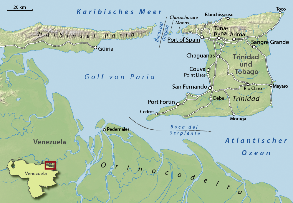
Trinidad is the larger and more populous of the two major islands of Trinidad and Tobago. The island lies off the northeastern coast of Venezuela and sits on the continental shelf of South America. It is often referred to as the southernmost island in the West Indies. With an area of , it is also the fifth largest in the West Indies. Name The original name for the island in the Arawaks' language was which meant "Land of the Hummingbird". Christopher Columbus renamed it ('The Island of the Trinity'), fulfilling a vow he had made before setting out on his third voyage. This has since been shortened to ''Trinidad''. History Caribs and Arawaks lived in Trinidad long before Christopher Columbus encountered the islands on his third voyage on 31 July 1498. The island remained Spanish until 1797, but it was largely settled by French colonists from the French Caribbean, especially Martinique.Besson, Gerard (2000-08-27). "Land of Beginnings – A historical digest", ''Newsday Ne ... [...More Info...] [...Related Items...] OR: [Wikipedia] [Google] [Baidu] |
Northern Range
The Northern Range is the range of tall hills across north Trinidad, the major island in the Republic of Trinidad and Tobago. The hills range from the Chaguaramas peninsula on the west coast to Toco in the east. The Northern Range covers approximately twenty-five percent of the land area of Trinidad. Geography The Northern Range runs from the Chaguaramas Peninsula in the west to Toco in the east. The eastern Northern Range (areas east of Arima) remain most heavily forested. Portions west of Arima, especially the southern slopes and valleys, have been extensively deforested, since they lie immediately north of the most heavily populated parts of the island. At the western end of the Northern Range, the capital city, Port of Spain, climbs into the hills and the valleys are settled and largely deforested. The Arima Valley remains as the westernmost valley that is still primarily forested, in a large part due to the presence of the Asa Wright Nature Centre in this valley. T ... [...More Info...] [...Related Items...] OR: [Wikipedia] [Google] [Baidu] |
Port Of Spain
Port of Spain ( Spanish: ''Puerto España''), officially the City of Port of Spain (also stylized Port-of-Spain), is the capital of Trinidad and Tobago and the third largest municipality, after Chaguanas and San Fernando. The city has a municipal population of 37,074 (2011 census), an urban population of 81,142 (2011 estimate) and a transient daily population of 250,000. It is located on the Gulf of Paria, on the northwest coast of the island of Trinidad and is part of a larger conurbation stretching from Chaguaramas in the west to Arima in the east with an estimated population of 600,000. The city serves primarily as a retail and administrative centre and it has been the capital of the island since 1757. It is also an important financial services centre for the CaribbeanCIA World Factbook Trinid ... [...More Info...] [...Related Items...] OR: [Wikipedia] [Google] [Baidu] |
Gulf Of Paria
The Gulf of Paria ( ; es, Golfo de Paria) is a shallow (180 m at its deepest) semi-enclosed inland sea located between the island of Trinidad (Republic of Trinidad and Tobago) and the east coast of Venezuela. It separates the two countries by as little as 15 km at its narrowest and 120 km at its widest points. The tides within the Gulf are semi-diurnal in nature with a range of approximately 1m. The Gulf of Paria is considered to be one of the best natural harbors on the Atlantic coast of the Americas. The jurisdiction of the Gulf of Paria is split between Trinidad and Tobago and Venezuela with Trinidad and Tobago having control over approximately (37.7%) and Venezuela the remainder (62.3%). It was originally named the Gulf of the Whale ( es, Golfo de la Ballena) by Christopher Columbus, but the 19th-century whaling industry eliminated whales from the area and populations have never recovered. Cartographic sources of the late 18th century repeatedly refer to it ... [...More Info...] [...Related Items...] OR: [Wikipedia] [Google] [Baidu] |
Trinidad And Tobago Guardian
The ''Trinidad and Tobago Guardian'' (together with the ''Sunday Guardian'') is the oldest daily newspaper in Trinidad and Tobago. The paper is considered the newspaper of record for Trinidad and Tobago. History Its first edition was published on Sunday 2 September 1917. The newspaper, now owned and published by Guardian Media Limited, began as a broadsheet but in November 2002 changed to tabloid format, known as the "G-sized Guardian". In June 2008, the paper changed to a smaller-size tabloid. The main office of the ''Guardian'' is located at St. Vincent Street, Port of Spain, with a branch office on Chancery Lane, San Fernando, and the Head office which is located on 4-10 Rodney Road in Chaguanas. On 2 September 2017, the ''Trinidad and Tobago Guardian'' celebrated its 100th anniversary. Shortly after on 11 September 2017, the company launched a new layout. The slogan of the paper is ''The Guardian of Democracy''. Since 1955, according to an advertisement in ''Editor & ... [...More Info...] [...Related Items...] OR: [Wikipedia] [Google] [Baidu] |
List Of Rivers In Trinidad And Tobago
This is a list of rivers of Trinidad and Tobago. Trinidad *Caroni River *Lalland River *Oropouche River *Salybia River *Mathura River *Maracas River *Shark River *Caura River *Valencia River *Caparo River *Marchine River (Affluentto the Lalland River) *Hondo River *Maraval River *Blue Basin River *Diego Martin River *San Juan River *St. Joseph River *Covigne River Gorge *Marianne River *Shark River *Yarra River *Chaguaramas River *Moruga River *Maturita River *Pilote River *Jack River *Santa Cruz River *Tunapuna River *Macoya/Trantrill River *Tacarigua River (Caura River) *Arouca River *Oropuna River *Mausica River *Arima River *Talparo River *Tumpuna River *Guanapo River *El Mamo River *Aripo River *Cumuto River *Guayamare River *Couva River *Guaracara River *Tarouba River *Cipero River *Guapo River *Cunupia River *Ravine Sable River Tobago * Courland River * Coffee River * Castara River * Bloody Bay River * Cook River (Tobago) * Bacolet River ** Sandy River * Hillsb ... [...More Info...] [...Related Items...] OR: [Wikipedia] [Google] [Baidu] |
Trinidad (island)
Trinidad is the larger and more populous of the two major islands of Trinidad and Tobago. The island lies off the northeastern coast of Venezuela and sits on the continental shelf of South America. It is often referred to as the southernmost island in the West Indies. With an area of , it is also the fifth largest in the West Indies. Name The original name for the island in the Arawaks' language was which meant "Land of the Hummingbird". Christopher Columbus renamed it ('The Island of the Trinity'), fulfilling a vow he had made before setting out on his third voyage. This has since been shortened to ''Trinidad''. History Caribs and Arawaks lived in Trinidad long before Christopher Columbus encountered the islands on his third voyage on 31 July 1498. The island remained Spanish until 1797, but it was largely settled by French colonists from the French Caribbean, especially Martinique.Besson, Gerard (2000-08-27). "Land of Beginnings – A historical digest", ''Newsday N ... [...More Info...] [...Related Items...] OR: [Wikipedia] [Google] [Baidu] |


