|
Mar Township
Marqu (, ) is a township in Doilungdêqên District in the Tibet Autonomous Region of China. See also *List of towns and villages in Tibet This is an alphabetical list of all populated places, including cities, towns and villages, in the Tibet Autonomous Region of western China. A *Alamdo *Alhar *Arza *Asog B * Baga *Bagar * Baidi *Baima *Baimai *Baixoi *Bamda *Banag *Banba ... Populated places in Tibet {{Tibet-geo-stub ... [...More Info...] [...Related Items...] OR: [Wikipedia] [Google] [Baidu] |
Doilungdêqên District
Doilungdêqên District is a district in Lhasa, north-west of the main center of Chengguan, Tibet Autonomous Region. It is largely agricultural or pastoral, but contains the western suburbs of the city of Lhasa. The Duilong River runs southeast through the district to the Lhasa River. A prehistoric site appears to be 3600–3000 years old. The district is home to the Tsurphu Monastery (1189) and the 17th century Nechung monastery. Topography Doilungdêgên is said to mean "valley of bliss" in Tibetan. The district is located in south-central Tibet. It contains the western suburbs of the city of Lhasa, capital of the Tibet Autonomous Region, which begin about from the city center. It covers an area of 2,704 square kilometers, with 94,969 acres of farmland. The district borders on the north Tibet grasslands in the northwest. The valley of the Duilong River leads south to the Lhasa River, and is contained by two ridges of the Nianqing Tanggula Mountains. The Duilong is in lengt ... [...More Info...] [...Related Items...] OR: [Wikipedia] [Google] [Baidu] |
Tibet Autonomous Region
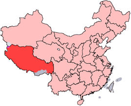
The Tibet Autonomous Region or Xizang Autonomous Region, often shortened to Tibet or Xizang, is a province-level autonomous region of the People's Republic of China in Southwest China. It was overlayed on the traditional Tibetan regions of Ü-Tsang and Kham. It was formally established in 1965 to replace the Tibet Area, the former administrative division of the People's Republic of China (PRC) established after the annexation of Tibet. The establishment was about five years after the 1959 Tibetan uprising and the dismissal of the Kashag, and about 13 years after the original annexation. The current borders of the Tibet Autonomous Region were generally established in the 18th century and include about half of historic Tibet, or the ethno-cultural Tibet. The Tibet Autonomous Region spans over and is the second-largest province-level division of China by area, after Xinjiang. Due to its harsh and rugged terrain, it is sparsely populated at just over 3.6 million people ... [...More Info...] [...Related Items...] OR: [Wikipedia] [Google] [Baidu] |
List Of Towns And Villages In Tibet
This is an alphabetical list of all populated places, including cities, towns and villages, in the Tibet Autonomous Region of western China. A *Alamdo *Alhar *Arza *Asog B * Baga *Bagar * Baidi *Baima *Baimai *Baixoi *Bamda *Banag *Banbar *Banggaidoi *Bangkor *Bangru * Bangxing * Baqên *Bar *Bêba *Bei *Bênqungdo *Bilung *Birba * Biru *Bogkamba *Boindoi * Bolo *Bongba *Boqê *Bumgyê *Bungona’og * Bünsum * Burang *Bushêngcaka C * Caina *Cakaxiang *Camco *Cawarong * Cazê *Cêgnê *Cêngdo *Cêri *Cêrwai *Chabug *Chacang *Chagla * Chagna *Chagyoi *Cha’gyüngoinba *Chalükong *Chamco *Chamda *Chamoling *Changgo *Changlung *Changmar *Charing *Chatang *Chawola *Chêcang *Chênggo *Chepzi *Chibma *Chido *Chigu *Chongkü *Chongsar *Chowa *Chubalung *Chubarong *Chuka *Chumba *Chumbu *Chunduixiang *Co Nyi *Cocholung * Codoi *Cogo * Coka *Comai *Cona (Tsona) *Co’nga *Congdü *Conggo * Coqên *Coyang * Cuoma *Cuozheqiangma D *Dagdong *Dagmo *Dagri *Dagring *Dagzhuka ... [...More Info...] [...Related Items...] OR: [Wikipedia] [Google] [Baidu] |


