|
Mandalika Island
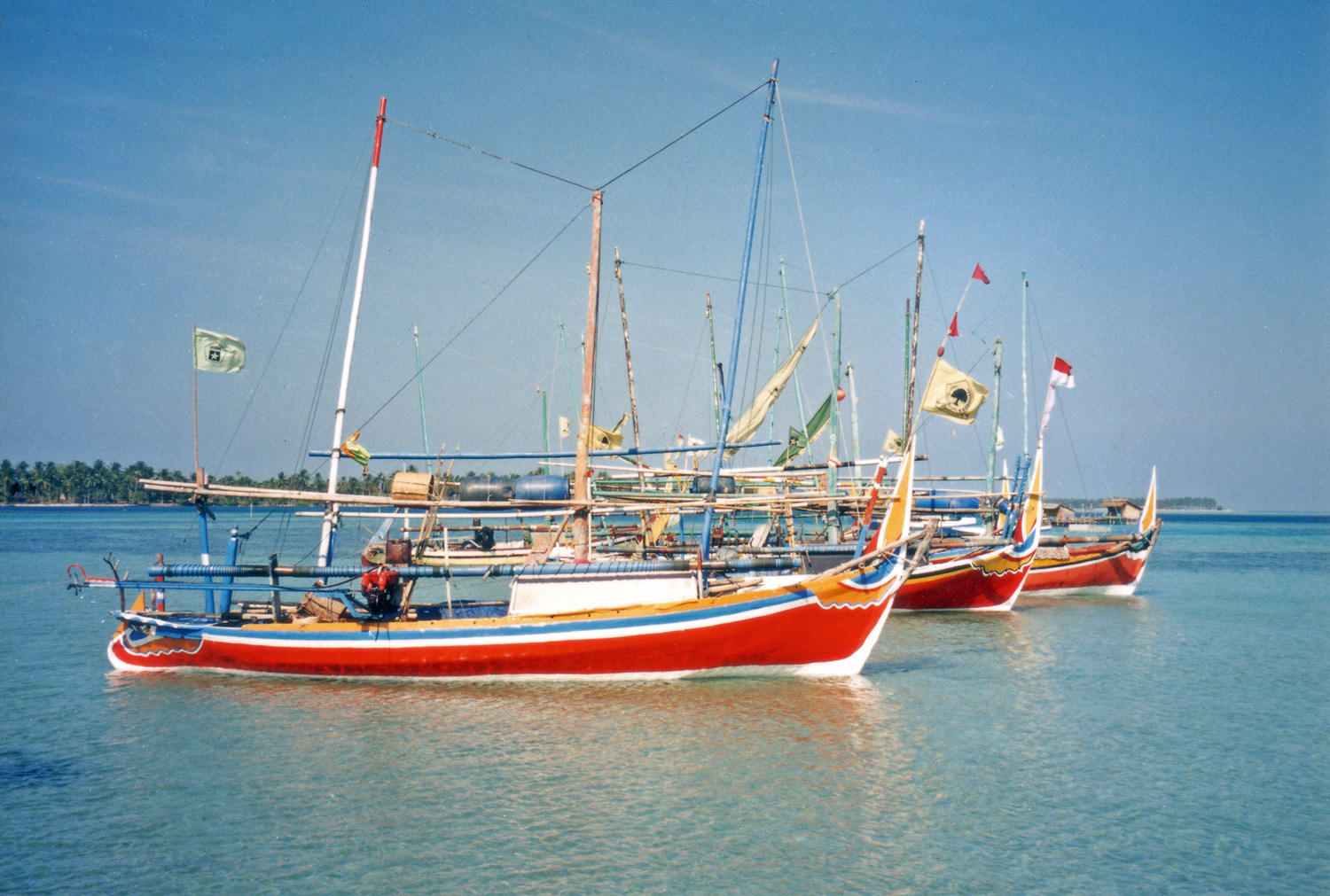
Mandalika Island is a small island in the Java Sea, which is about 2 kilometers distant from Donorejo village of Jepara Regency in Central Java, Indonesia. The island is situated in the north of Central Java coast, opposite to Portuguese Fort beach and close to Mount Muria Mount Muria or Gunung Muria is a dormant volcano on the north coast of Java, Indonesia. It is located in the center of the Muria peninsula, which juts northward into the Java Sea on the north coast of Central Java, Indonesia east of Semarang, t .... The island is just 500 meters from the fort and can be seen from there. The island has become a tourist attraction already. This island is partially forested and usually uninhabited. There are also temporary housing for fishermen. A light house is located on the island, mainly to guide local fishermen. There is a tomb of Syed Ustman, who was a nayaka (minister) of the Kingdom Kalinyamat. The beach of Mandalika island has crystal clear water, but rocky and ste ... [...More Info...] [...Related Items...] OR: [Wikipedia] [Google] [Baidu] |
Java Sea
The Java Sea ( id, Laut Jawa, jv, Segara Jawa) is an extensive shallow sea on the Sunda Shelf, between the Indonesian islands of Borneo to the north, Java to the south, Sumatra to the west, and Sulawesi to the east. Karimata Strait to its northwest links it to the South China Sea. It is a part of the western Pacific Ocean. Geography The Java Sea covers the southern section of the Sunda Shelf. A shallow sea, it has a mean depth of . It measures about east-west by north-southGoogleEarth and occupies a total surface area of . It formed as sea levels rose at the end of the last ice age. Its almost uniformly flat bottom, and the presence of drainage channels (traceable to the mouths of island rivers), indicate that the Sunda Shelf was once a stable, dry, low-relief land area (peneplain) above which were left standing a few monadnocks (granite hills that, due to their resistance to erosion, form the present islands). Extent The International Hydrographic Organization (IHO) defi ... [...More Info...] [...Related Items...] OR: [Wikipedia] [Google] [Baidu] |
Indonesia
Indonesia, officially the Republic of Indonesia, is a country in Southeast Asia and Oceania between the Indian and Pacific oceans. It consists of over 17,000 islands, including Sumatra, Java, Sulawesi, and parts of Borneo and New Guinea. Indonesia is the world's largest archipelagic state and the 14th-largest country by area, at . With over 275 million people, Indonesia is the world's fourth-most populous country and the most populous Muslim-majority country. Java, the world's most populous island, is home to more than half of the country's population. Indonesia is a presidential republic with an elected legislature. It has 38 provinces, of which nine have special status. The country's capital, Jakarta, is the world's second-most populous urban area. Indonesia shares land borders with Papua New Guinea, East Timor, and the eastern part of Malaysia, as well as maritime borders with Singapore, Vietnam, Thailand, the Philippines, Australia, Palau, and India ... [...More Info...] [...Related Items...] OR: [Wikipedia] [Google] [Baidu] |
Central Java
Central Java ( id, Jawa Tengah) is a province of Indonesia, located in the middle of the island of Java. Its administrative capital is Semarang. It is bordered by West Java in the west, the Indian Ocean and the Special Region of Yogyakarta in the south, East Java in the east, and the Java Sea in the north. It has a total area of 32,800.69 km2, with a population of 36,516,035 at the 2020 Census making it the third-most populous province in both Java and Indonesia after West Java and East Java. The official estimate as at mid 2021 was 36,742,501.Badan Pusat Statistik, Jakarta, 2022. The province also includes the island of Nusakambangan in the south (close to the border of West Java), and the Karimun Jawa Islands in the Java Sea. Central Java is also a cultural concept that includes the Yogyakarta Special Region, in turn including the city of Yogyakarta; however, administratively that city and its surrounding regencies have formed a separate special region (equivalent to ... [...More Info...] [...Related Items...] OR: [Wikipedia] [Google] [Baidu] |
Jepara Regency
Jepara ( jv, ꦗꦼꦥꦫ) is a Regencies of Indonesia, regency in the northeast of the Indonesian province of Central Java. It covers an area of 1,004.13 km2 and had a population of 1,097,280 at the 2010 census and 1,184,947 at the 2020 census. Its capital is Jepara town. History People believed to have come from South Yunnan region migrated into the northern tip of Java during a time when Jepara was still separated by the Juwana Strait. In the 16th century, Jepara was an important port; in early 1513, its king, Yunnus (Pati Unus) led an attack against Portuguese Empire, Portuguese Malacca. His force is said to have been made up of one hundred ships and 5000 men from Jepara and Palembang but was defeated. Between 1518 and 1521 he apparently ruled over Demak Sultanate, Demak. The rule of Ratu ('Queen') Kalinyamat in the latter 16th century was, however, Jepara's most influential. Jepara again attacked Malacca in 1551 this time with Johor but was defeated, and in 1574 besie ... [...More Info...] [...Related Items...] OR: [Wikipedia] [Google] [Baidu] |
Time In Indonesia
The Indonesian Archipelago geographically stretches across four time zones from UTC+06:00 in Aceh to UTC+09:00 in Papua. However, the Indonesian government recognises only three time zones in its territory, namely: *Western Indonesia Time (WIB) — seven hours ahead ( UTC+07:00) of the Coordinated Universal Time (UTC); *Central Indonesia Time (WITA) — eight hours ahead ( UTC+08:00) of UTC; *Eastern Indonesia Time (WIT) — nine hours ahead ( UTC+09:00) of UTC. The boundary between the Western and Central time zones was established as a line running north between Java and Bali through the provincial boundaries of West and Central Kalimantan. The border between the Central and Eastern time zones runs north from the eastern tip of Indonesian Timor to the eastern tip of Sulawesi. Daylight saving time (DST) is no longer observed anywhere in Indonesia. Current usage In Indonesia Indonesia, officially the Republic of Indonesia, is a country in Southeast Asia and Oceania b ... [...More Info...] [...Related Items...] OR: [Wikipedia] [Google] [Baidu] |
Portuguese Fort (Jepara)
The so-called Portuguese Fort, or Benteng Portugis, is a historical fort located in the village Banyumanis adjacent to the village of Ujung Batu, District of Keling, Jepara Regency, the province of Central Java, Indonesia. It is said that the fortress was built by the Government Mataram in 1613–1645, with partnership of the Portuguese (hence the name) as the central defense to repel the enemy who came from Java Sea (referring to the Dutch) . Currently the Portuguese Fort is one of the leading tourist destination of Jepara. Location of the fort is also adjacent to Mandalika Island Mandalika Island is a small island in the Java Sea, which is about 2 kilometers distant from Donorejo village of Jepara Regency in Central Java, Indonesia. The island is situated in the north of Central Java coast, opposite to Portuguese Fort b .... References {{coord, 6, 24, 13, S, 110, 55, 5, E, source:wikidata, display=title Tourism in Jepara Forts in Indonesia Portuguese forts Portugue ... [...More Info...] [...Related Items...] OR: [Wikipedia] [Google] [Baidu] |
Mount Muria
Mount Muria or Gunung Muria is a dormant volcano on the north coast of Java, Indonesia. It is located in the center of the Muria peninsula, which juts northward into the Java Sea on the north coast of Central Java, Indonesia east of Semarang, the capital of the province. Mount Muria is 1602 meters high but once was maybe twice that height. Mount Muria was once an island, separated from Java by the Muria Strait. This strait closed around 1657. The Muria area is notable for a number of reasons. It contains the grave sites of two of the Wali Sanga of Java - Sunan Muria, also known as Raden Umar Said, whose grave is in Colo on the southern slopes of Mount Muria, and Sunan Kudus, known also as Ja'far Shadiq, whose grave is in the city of Kudus to the south of Mount Muria. The Wali Sanga are the nine Islamic Saints associated with the origins of Islam in Java. As a consequence the grave is part of the network of sites in Java considered to be sacred. The name Kudus means "holy." T ... [...More Info...] [...Related Items...] OR: [Wikipedia] [Google] [Baidu] |
Tourism In Jepara
Tourism in Jepara is an important component of the economy of Jepara and a significant source of tax revenue. 8472 Tourism in Jepara attract foreign visitors in 2010. Jepara is a town which known for their culinary, education, tourism, and rich cultural heritage. There are many possibilities and opportunities lies for the city to prosper and benefits more, but yet until now the government has not yet fully utilized them. Jepara although only a small town but has many tourist attractions, the mountain tourism, beach tourism, underwater tours, tour the islands. Foreign tourists often visit Tirto Samodra Beach (Bandengan Beach), Karimun Java, Karimunjava Island (Crimon Java), Kartini Beach, etc. Branding In late September 2008 Jepara Regent Hendro Martojo announced that "Visit Jepara" brand used by cities and countries official tourism promotion campaign, Visit Jepara have themed logo Jepara wood carving. Visit Jepara reflect the brand invites people to enjoy the city's natural ... [...More Info...] [...Related Items...] OR: [Wikipedia] [Google] [Baidu] |
Greater Sunda Islands
The Greater Sunda Islands (Indonesian and Malay: ''Kepulauan Sunda Besar'') are four tropical islands situated within Indonesian Archipelago, in the Pacific Ocean. The islands, Borneo, Java, Sulawesi and Sumatra, are internationally recognised for their ecological diversity and rich culture. Together with the Lesser Sunda Islands to their southeast, they comprise the archipelago known as the Sunda Islands. Mainly part of Indonesia, each island is diverse in its ethnicity, culture and biological attributes. The islands have a long and rich history which has shaped their cultural backgrounds. Sumatra Geography Sumatra is the second largest, most westerly oriented Indonesian island, and the sixth largest island globally. Spanning , Sumatra is home to human civilisations and tropical rainforests, which harbour a huge range of wildlife. Its close proximity to the Equator (1º S, 101º E) dictates its tropical climate, so that it is subject to the forces of climatic events El Niño ... [...More Info...] [...Related Items...] OR: [Wikipedia] [Google] [Baidu] |
Islands Of Central Java
An island (or isle) is an isolated piece of habitat that is surrounded by a dramatically different habitat, such as water. Very small islands such as emergent land features on atolls can be called islets, skerries, cays or keys. An island in a river or a lake island may be called an eyot or ait, and a small island off the coast may be called a holm. Sedimentary islands in the Ganges delta are called chars. A grouping of geographically or geologically related islands, such as the Philippines, is referred to as an archipelago. There are two main types of islands in the sea: continental and oceanic. There are also artificial islands, which are man-made. Etymology The word ''island'' derives from Middle English ''iland'', from Old English ''igland'' (from ''ig'' or ''ieg'', similarly meaning 'island' when used independently, and -land carrying its contemporary meaning; cf. Dutch ''eiland'' ("island"), German ''Eiland'' ("small island")). However, the spelling of the word ... [...More Info...] [...Related Items...] OR: [Wikipedia] [Google] [Baidu] |


