|
Madera Canyon (Arizona)
Madera Canyon is a canyon in the northwestern face of the Santa Rita Mountains, twenty-five miles southeast of Tucson, Arizona. As part of the Coronado National Forest, Madera Canyon has campsites, picnic areas, and miles of hiking trails. The canyon is also used as a resting place for migrating birds, and it is thus known as a premier birdwatching area. Madera Canyon was originally named White House Canyon, after a prominent white adobe house was built there in the late 19th century. The canyon was renamed sometime in the early 1900s, although some locals still use the original name. Flora and fauna Madera Canyon is located in the Santa Rita Mountains, which is one of the largest of the Madrean Sky Islands. The canyon and its immediate surroundings are therefore home to wide variety of flora and fauna, ranging from cactus covered desert in the lower reaches of the canyon to aspen and fir forest on Mount Wrightson. With fifteen species of hummingbird, elegant trogon, sulphu ... [...More Info...] [...Related Items...] OR: [Wikipedia] [Google] [Baidu] |
Santa Rita Mountains
The Santa Rita Mountains (O'odham language, O'odham: To:wa Kuswo Doʼag), located about 65 km (40 mi) southeast of Tucson, Arizona, extend 42 km (26 mi) from north to south, then trending southeast. They merge again southeastwards into the Patagonia Mountains, trending northwest by southeast. The highest point in the range, and the highest point in the Tucson area, is Mount Wrightson, with an elevation of 9,453 feet (2,881 m), The range contains Madera Canyon (Arizona), Madera Canyon, one of the world's premier birding areas. The Smithsonian Institution's Fred Lawrence Whipple Observatory is located on Mount Hopkins (Arizona), Mount Hopkins. The range is one of the Madrean sky islands. The Santa Rita Mountains are mostly within the Coronado National Forest. Prior to 1908 they were the principal component of Santa Rita National Forest, which was combined with other small forest tracts to form Coronado. Much of the range lies within the Mt. Wrightson Wilderness ... [...More Info...] [...Related Items...] OR: [Wikipedia] [Google] [Baidu] |
Elegant Trogon
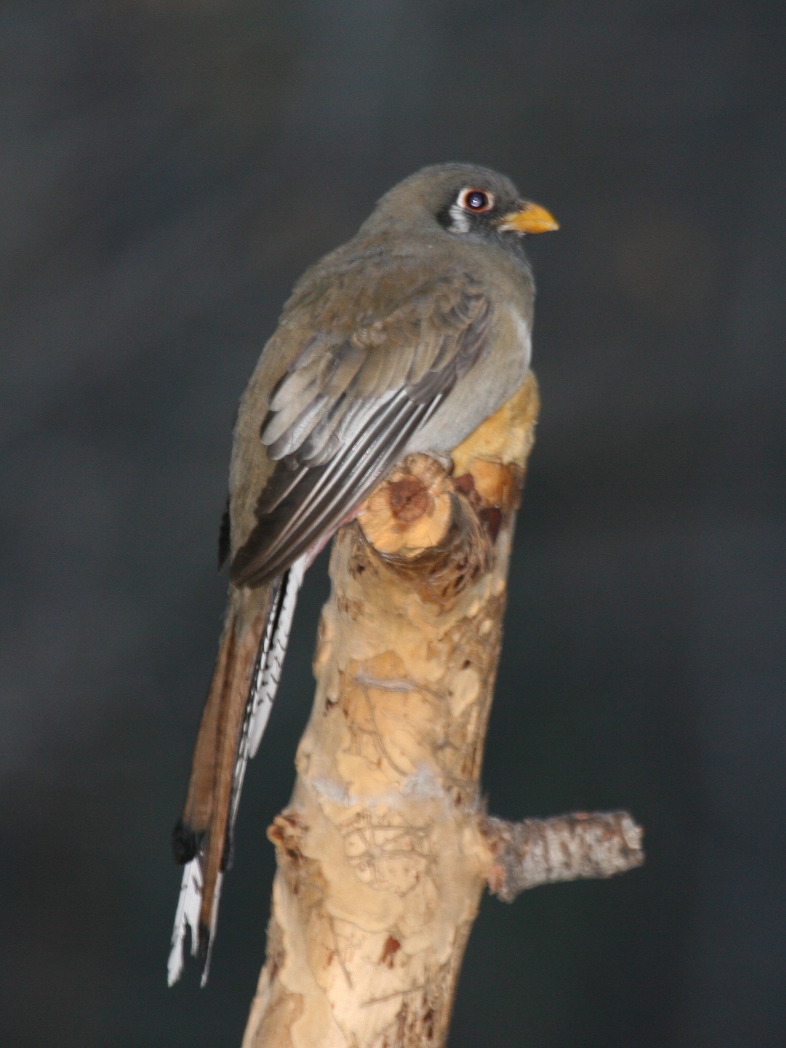
The elegant trogon (''Trogon elegans''), also known as the coppery-tailed trogon, is a near passerine bird in the trogon family. Taxonomy ''T. elegans'' has five recognized subspecies, including the nominate subspecies: *''T. e. elegans'' Gould, 1834 *''T. e. ambiguus'' Gould, 1835 *''T. e. canescens'' Van Rossem, 1934 *''T. e. goldmani'' Nelson, 1898 *''T. e. lubricus'' J. L. Peters, 1945 BirdLife International and Handbook of the Birds of the World consider ''T. e. ambiguus'' to be its own species, as ''Trogon ambiguus'', with ''Trogon elegans'' ''sensu stricto'' being the Central American population. The IUCN Red List follows this taxonomy, but Avibase and Clements do not. Description This species is long and weighs (average ). Like other trogons, elegant trogons have distinctive male and female plumages (sexual dimorphism), with soft feathers. Both sexes have a white undertail with fine horizontal black barring. The undertail also has large white tips spaced evenly endin ... [...More Info...] [...Related Items...] OR: [Wikipedia] [Google] [Baidu] |
USGS Map Of Santa Rita And Patagonia Mts 1910
The United States Geological Survey (USGS), formerly simply known as the Geological Survey, is a scientific agency of the United States government. The scientists of the USGS study the landscape of the United States, its natural resources, and the natural hazards that threaten it. The organization's work spans the disciplines of biology, geography, geology, and hydrology. The USGS is a fact-finding research organization with no regulatory responsibility. The agency was founded on March 3, 1879. The USGS is a bureau of the United States Department of the Interior; it is that department's sole scientific agency. The USGS employs approximately 8,670 people and is headquartered in Reston, Virginia. The USGS also has major offices near Lakewood, Colorado, at the Denver Federal Center, and Menlo Park, California. The current motto of the USGS, in use since August 1997, is "science for a changing world". The agency's previous slogan, adopted on the occasion of its hundredth anniversa ... [...More Info...] [...Related Items...] OR: [Wikipedia] [Google] [Baidu] |
Rocky Mountains
The Rocky Mountains, also known as the Rockies, are a major mountain range and the largest mountain system in North America. The Rocky Mountains stretch in straight-line distance from the northernmost part of western Canada, to New Mexico in the southwestern United States. Depending on differing definitions between Canada and the U.S., its northern terminus is located either in northern British Columbia's Terminal Range south of the Liard River and east of the Trench, or in the northeastern foothills of the Brooks Range/ British Mountains that face the Beaufort Sea coasts between the Canning River and the Firth River across the Alaska-Yukon border. Its southernmost point is near the Albuquerque area adjacent to the Rio Grande rift and north of the Sandia–Manzano Mountain Range. Being the easternmost portion of the North American Cordillera, the Rockies are distinct from the tectonically younger Cascade Range and Sierra Nevada, which both lie farther to its west. The ... [...More Info...] [...Related Items...] OR: [Wikipedia] [Google] [Baidu] |
Orographic Lift
Orographic lift occurs when an air mass is forced from a low elevation to a higher elevation as it moves over rising terrain. As the air mass gains altitude it quickly cools down adiabatically, which can raise the relative humidity to 100% and create clouds and, under the right conditions, precipitation. Orographic lifting can have a number of effects, including precipitation, rain shadowing, leeward winds, and associated clouds. Precipitation Precipitation induced by orographic lift occurs in many places throughout the world. Examples include: * The Mogollon Rim in central Arizona * The western slope of the Sierra Nevada range in California * The mountains near Baja California North – specifically La Bocana to Laguna Hanson. * The windward slopes of Khasi and Jayantia Hills (see Mawsynram) in the state of Meghalaya in India. * The Western Highlands of Yemen, which receive by far the most rain in Arabia. * The Western Ghats that run along India's western coast. * The Grea ... [...More Info...] [...Related Items...] OR: [Wikipedia] [Google] [Baidu] |
Sonoran Desert
The Sonoran Desert ( es, Desierto de Sonora) is a desert in North America and ecoregion that covers the northwestern Mexican states of Sonora, Baja California, and Baja California Sur, as well as part of the southwestern United States (in Arizona and California). It is the hottest desert in both Mexico and the United States. It has an area of . In phytogeography, the Sonoran Desert is within the Sonoran Floristic province of the Madrean Region of southwestern North America, part of the Holarctic realm of the northern Western Hemisphere. The desert contains a variety of unique endemic plants and animals, notably, the saguaro (''Carnegiea gigantea'') and organ pipe cactus (''Stenocereus thurberi''). The Sonoran Desert is clearly distinct from nearby deserts (e.g., the Great Basin, Mojave, and Chihuahuan deserts) because it provides subtropical warmth in winter and two seasons of rainfall (in contrast, for example, to the Mojave's dry summers and cold winters). This creates an ex ... [...More Info...] [...Related Items...] OR: [Wikipedia] [Google] [Baidu] |
Santa Cruz River (Arizona)
The Santa Cruz River ( es, Río Santa Cruz " Holy Cross River") is a tributary river to the Gila River in Southern Arizona and northern Sonora, Mexico. It is approximately long. Course The Santa Cruz has its headwaters in the high intermontane grasslands of the San Rafael Valley to the southeast of Patagonia, Arizona, between the Canelo Hills to the east and the Patagonia Mountains to the west, just north of the international border. It flows southward into Mexico past Santa Cruz, Sonora and turns westward around the south end of the Sierra San Antonio near Miguel Hidalgo (San Lázaro), thence north-northwest to reenter the United States just to the east of Nogales and southwest of Kino Springs. It then continues northward from the international border past the Tumacacori National Historical Park, Tubac, Green Valley, Sahuarita, San Xavier del Bac, Tucson, Marana, and Picacho Peak State Park to the Santa Cruz Flats just to the south of Casa Grande and the Gila River. B ... [...More Info...] [...Related Items...] OR: [Wikipedia] [Google] [Baidu] |
Riparian Corridor
A riparian zone or riparian area is the interface between land and a river or stream. Riparian is also the proper nomenclature for one of the terrestrial biomes of the Earth. Plant habitats and communities along the river margins and banks are called riparian vegetation, characterized by hydrophilic plants. Riparian zones are important in ecology, environmental resource management, and civil engineering because of their role in soil conservation, their habitat biodiversity, and the influence they have on fauna and aquatic ecosystems, including grasslands, woodlands, wetlands, or even non-vegetative areas. In some regions, the terms riparian woodland, riparian forest, riparian buffer zone, riparian corridor, and riparian strip are used to characterize a riparian zone. The word ''riparian'' is derived from Latin '' ripa'', meaning " river bank". Characteristics Riparian zones may be natural or engineered for soil stabilization or restoration. These zones are important natural ... [...More Info...] [...Related Items...] OR: [Wikipedia] [Google] [Baidu] |
Wild Turkeys
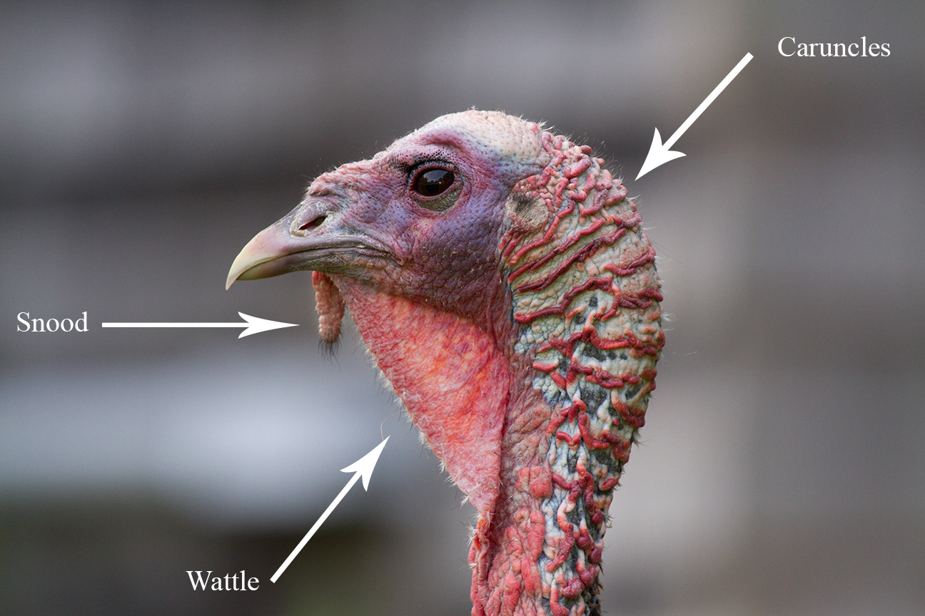
The wild turkey (''Meleagris gallopavo'') is an upland ground bird native to North America, one of two extant species of turkey and the heaviest member of the order Galliformes. It is the ancestor to the domestic turkey, which was originally derived from a southern Mexican subspecies of wild turkey (not the related ocellated turkey). Description Adult wild turkeys have long reddish-yellow to grayish-green legs. The body feathers are generally blackish and dark, sometimes grey brown overall with a coppery sheen that becomes more complex in adult males. Adult males, called toms or gobblers, have a large, featherless, reddish head, red throat, and red wattles on the throat and neck. The head has fleshy growths called caruncles. Juvenile males are called jakes; the difference between an adult male and a juvenile is that the jake has a very short beard and his tail fan has longer feathers in the middle. The adult male's tail fan feathers will be all the same length. When males a ... [...More Info...] [...Related Items...] OR: [Wikipedia] [Google] [Baidu] |
Ring-tailed Cat
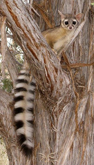
The ringtail (''Bassariscus astutus'') is a mammal of the Procyonidae, raccoon family native to arid regions of North America. It is widely distributed and well adapted to disturbed areas. It has been legally trapped for its fur. It is listed as Least Concern on the IUCN Red List. It is also known as the ringtail cat, ring-tailed cat, miner's cat or bassarisk, and is sometimes called a cacomistle, though this term seems to be more often used to refer to ''cacomistle, Bassariscus sumichrasti''. The ringtail is the state mammal of Arizona. Description The ringtail is black to dark brown in color with pale underparts. The animal has a pointed muzzle with long whiskers, similar to that of a fox (its Latin name means ‘clever little fox’) and its body resembles that of a cat. The ringtailed's face resembles a mask as dark brown and black hair surround its eyes. These animals are characterized by a long black and white "ringed" tail with 14–16 stripes, which is about the same ... [...More Info...] [...Related Items...] OR: [Wikipedia] [Google] [Baidu] |
Coati
Coatis, also known as coatimundis (), are members of the family Procyonidae in the genera ''Nasua'' and ''Nasuella''. They are diurnal mammals native to South America, Central America, Mexico, and the southwestern United States. The name "coatimundi" comes from the Tupian languages of Brazil, where it means "lone coati". Locally in Belize, the coati is known as "quash". Physical characteristics Adult coatis measure from head to the base of the tail, which can be as long as their bodies. Coatis are about tall at the shoulder and weigh between , about the size of a large house cat. Males can become almost twice as large as females and have large, sharp canine teeth. The measurements above relate to the white-nosed and South America coatis. The two mountain coatis are smaller. All coatis share a slender head with an elongated, flexible, slightly upward-turned nose, small ears, dark feet, and a long, non-prehensile tail used for balance and signaling. Ring-tailed coatis have ... [...More Info...] [...Related Items...] OR: [Wikipedia] [Google] [Baidu] |
New World Warbler
The New World warblers or wood-warblers are a group of small, often colorful, passerine birds that make up the family Parulidae and are restricted to the New World. They are not closely related to Old World warblers or Australian warblers. Most are arboreal, but some, like the ovenbird and the two waterthrushes, are primarily terrestrial. Most members of this family are insectivores. This group likely originated in northern Central America, where the greatest number of species and diversity between them is found. From there, they spread north during the interglacial periods, mainly as migrants, returning to the ancestral region in winter. Two genera, '' Myioborus'' and ''Basileuterus'', seem to have colonized South America early, perhaps before the two continents were linked, and together constitute most warbler species of that region. The scientific name for the family, Parulidae, originates from the fact that Linnaeus in 1758 named the northern parula as a tit, ''Parus amer ... [...More Info...] [...Related Items...] OR: [Wikipedia] [Google] [Baidu] |


.jpg)