|
M-6 Highway (Montenegro)
M-6 highway ( cnr, Magistralni put M-6, script=Latn) (previously R-5 and parts of M-8 and R-4) is a Montenegrin roadway. History Part of the M-6 highway that was previously M-8 highway was built as part of the larger M-8 highway within the Yugoslav highway network, spanning Bosnia and Herzegovina, Montenegro and Serbia. It connected Pljevlja with Foča in Bosnia and Herzegovina, and Prijepolje, Sjenica and Novi Pazar in Serbia. However, construction was never completed on the Montenegrin section of the road. Section between Jasenovo Polje and Krnovo was only main road built in Montenegro during 1990s. Section from Žabljak to Šavnik Šavnik ( cnr, Шавник, ) is a town in Montenegro and administrative center of the Šavnik Municipality. It is located at the confluence of three rivers - Bukovica, Bijela and Šavnik, at an altitude of 840 meters. It is the lowest lying set ... was built in 2010. In January 2016, the Ministry of Transport and Maritime Affairs published by ... [...More Info...] [...Related Items...] OR: [Wikipedia] [Google] [Baidu] |
Serbia
Serbia (, ; Serbian language, Serbian: , , ), officially the Republic of Serbia (Serbian language, Serbian: , , ), is a landlocked country in Southeast Europe, Southeastern and Central Europe, situated at the crossroads of the Pannonian Basin and the Balkans. It shares land borders with Hungary to the north, Romania to the northeast, Bulgaria to the southeast, North Macedonia to the south, Croatia and Bosnia and Herzegovina to the west, and Montenegro to the southwest, and claims a border with Albania through the Political status of Kosovo, disputed territory of Kosovo. Serbia without Kosovo has about 6.7 million inhabitants, about 8.4 million if Kosvo is included. Its capital Belgrade is also the List of cities in Serbia, largest city. Continuously inhabited since the Paleolithic Age, the territory of modern-day Serbia faced Slavs#Migrations, Slavic migrations in the 6th century, establishing several regional Principality of Serbia (early medieval), states in the early Mid ... [...More Info...] [...Related Items...] OR: [Wikipedia] [Google] [Baidu] |
Prijepolje
Prijepolje ( sr-cyr, Пријепоље, ) is a town and municipality located in the Zlatibor District of southwestern Serbia. As of 2011 census, the town has 13,330 inhabitants, while the municipality has 37,059 inhabitants. Etymology One possible meaning of the name Prijepolje is "Prija's field", where Prija is the owner of ''polje'', the "field" in English. However, a more likely theory is that the name originates from the location of Prijepolje and its relationship to the travels of caravans. When those caravans were passing through the area which would become Prijepolje, they would arrive at the settlement "before the fields", where the present day neighborhoods of Ivanje and Velika Župa are located. "Prije" means "before", and "polje" means "field", hence, the location might be called Prijepolje. Geography Prijepolje is located at the confluence of the fast-flowing Lim and Mileševka rivers. It is also situated along the road from Belgrade to the Adriatic sea, as well ... [...More Info...] [...Related Items...] OR: [Wikipedia] [Google] [Baidu] |
Đurđevića Tara Bridge
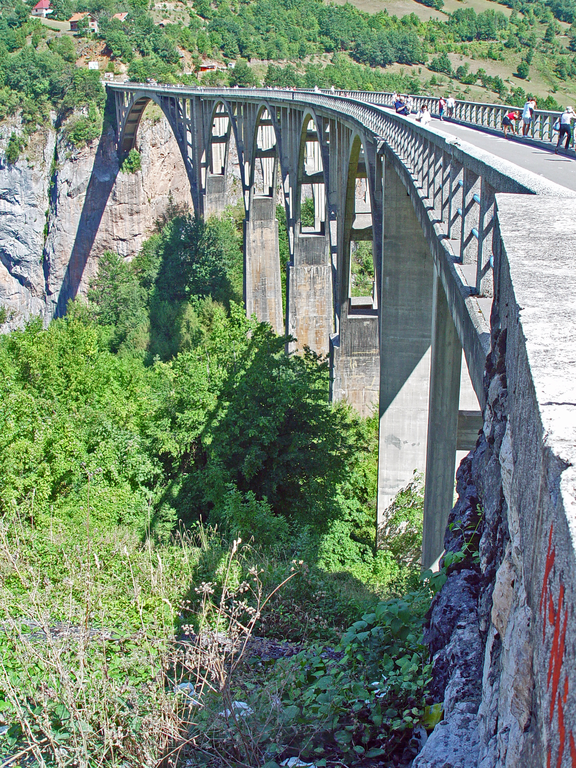
The Đurđevića Tara Bridge ( cyrl, Мост на Ђурђевића Тари, Most na Đurđevića Tari, ) is a concrete arch bridge over the Tara River in northern Montenegro. It is located at the crossroads between the municipalities of Mojkovac, Pljevlja and Žabljak. The exact location of the bridge is between the villages of Budečevica and Trešnjica. Construction The Đurđevića Tara Bridge, which was designed by Mijat Trojanović, was built between 1937 and 1940 in the Kingdom of Yugoslavia. The project's Chief Engineer was Isaac Russo. The bridge has five arches; the largest span is . The roadway stands above the Tara River. At the time of its completion, it was the biggest vehicular concrete arch bridge in Europe. World War II Much of Montenegro, including the Tara Canyon, came under Italian occupation following the German-led Invasion of Yugoslavia in April 1941. As the mountainous terrain made it suitable for guerrilla warfare, a partisan uprising occurred ... [...More Info...] [...Related Items...] OR: [Wikipedia] [Google] [Baidu] |
Žabljak
Žabljak ( Serbian / Montenegrin: Жабљак, ) is a small town in northern Montenegro. It has a population of 1,723. Žabljak is the seat of Žabljak Municipality (2011 population: 3,569). The town is in the centre of the Durmitor mountain region and with an altitude of 1,456 metres, it is the highest situated Balkan town. History The first Slav name of the place was ''Varezina voda'' (Варезина вода) possibly because of the strong source of drinkable water nearby, making a settlement possible. Later, the town was renamed ''Hanovi'' because it was where caravans rested. The modern name dates from 1870, when in a single day the building of a school, church and captain's home began. However, almost all the original buildings were destroyed during the Balkan Wars. All that has remained is the old church of Sv. Preobraženje (Holy Transfiguration), built in 1862 as a monument to a Montenegrin victory in the battle against the Ottoman Empire. After Žabljak was establi ... [...More Info...] [...Related Items...] OR: [Wikipedia] [Google] [Baidu] |
Matica Crnogorska
Matica crnogorska ( cnr, Матица црногорска, ) is a Montenegrin cultural institution. It was founded in 1993 as a non-governmental organization which promotes Montenegrin national and cultural identity and the Montenegrin language. In 2008, the Parliament of Montenegro adopted the Law on Matica crnogorska, which gave it the status of an independent cultural institution. In 2000, it began publishing the magazine "Matica". History Matica crnogorska was formed on 22 May 1993 in Cetinje. The Matica was one of firm supporters of the country's independence. On 18 March 2008, the Parliament of Montenegro passed the Act of Matica crnogorska, which signifies it as an independent organization in the cultural field. Presidents Presidents of Matica Crnogorska: *Dragan Radulović (22 May 2013 – present) *Branko Banjević (23 January 1999 – 22 May 2013) *Božina Ivanović Božina M. Ivanović ( sr-cyrl, Божина М. Ивановић; 31 December 1931 – 10 October 2 ... [...More Info...] [...Related Items...] OR: [Wikipedia] [Google] [Baidu] |
Federal Executive Council (Yugoslavia)
The Federal Executive Council (FEC, Serbo-Croatian, ''Savezno izvršno vijeće (SIV)'', Савезно извршно веће (СИВ)) was the executive body of the Socialist Federal Republic of Yugoslavia (SFRY) responsible for state affairs and for supervising the implementation of laws. It consisted of up to 15 members elected by the Federal Assembly for a four-year term and the presidents of executive councils of republics and provinces. The Federal Executive Council played an important role in the Government of the SFRY from its creation in 1953 until the breakup of Yugoslavia in 1992. Structure The FEC was led by a President (also called Prime Minister) and two vice presidents, who were elected by the S.F.R.Y assembly on request of the President of the Socialist Federalist Republic of Yugoslavia. Council members (also called secretariats) were elected to equally represent the six republics making up the S.F.R.Y, as well as the two autonomous regions in Serbia, Kosovo ... [...More Info...] [...Related Items...] OR: [Wikipedia] [Google] [Baidu] |
Novi Pazar
Novi Pazar ( sr-cyr, Нови Пазар, lit. "New Bazaar"; ) is a city located in the Raška District of southwestern Serbia. As of the 2011 census, the urban area has 66,527 inhabitants, while the city administrative area has 100,410 inhabitants. The city is the cultural center of the Bosniaks in Serbia and the region of Sandžak. A multicultural area of Muslims and Orthodox Christians, many monuments of both religions, like the Altun-Alem Mosque and the Church of the Holy Apostles Peter and Paul, are found in the region which has a total of 30 protected monuments of culture. Name During the 14th century under the old Serbian fortress of Stari Ras, an important market-place named ''Trgovište'' started to develop. By the middle of the 15th century, in the time of the final Ottoman Empire conquest of Old Serbia, another market-place was developing some 11 km to the east. The older place became known as ''Staro Trgovište'' (Old Trgovište, tr, Eski Pazar) and the younge ... [...More Info...] [...Related Items...] OR: [Wikipedia] [Google] [Baidu] |
Sjenica
Sjenica ( sr-cyr, Сјеница, ) is a town and municipality located in the Zlatibor District of southwestern Serbia. The population of the town, according to 2011 census, is 14,060 inhabitants, while the municipality has 26,392. Sjenica is situated in the Pešter plateau, and is surrounded by the mountains of Jadovnik, Ozren, Giljeva and Javor. History It is an old town, first mentioned in 1253 AD as a place where many merchants rested and paid taxes while on their way to Dubrovnik. ''Voivode'' Stefan Vasoje, the son of King Stefan Konstantin (r. 1321–1322), received Sjenica as an appanage by Emperor Stefan Dušan (r. 1331–1355). During the reign of the Ottoman Empire, Sjenica was used as a fortified site. On a nearby hill the Ottomans built a fortress, which was later demolished. Next to the fortress was a merchants' quarter and few wooden residential homes. In the 19th century, Sjenica was considered a high priority because of its political, military and strategic si ... [...More Info...] [...Related Items...] OR: [Wikipedia] [Google] [Baidu] |
Foča
Foča ( sr-Cyrl, Фоча, ) is a town and a municipality located in Republika Srpska in south-eastern Bosnia and Herzegovina, on the banks of Drina river. As of 2013, the town has a population of 12,234 inhabitants, while the municipality has 18,288 inhabitants. Foča houses some faculties (including the Medical and Orthodox Theological Faculty of Saint Basil of Ostrog) from the Istočno Sarajevo University. It is also home to the "Seminary of Saint Peter of Sarajevo and Dabar-Bosna", one of seven seminaries in the Serbian Orthodox Church. Foča was also, until 1992, home to one of Bosnia's most important Islamic high schools, the Madrasa of Mehmed Pasha Kukavica. The Sutjeska National Park, which is the oldest National Park in Bosnia and Herzegovina, is located in the municipality. History Early history The town was known as Hotča during medieval times. It was then known as a trading centre on route between Ragusa (now Dubrovnik) and Constantinople (now Istanbul, Turkey) ... [...More Info...] [...Related Items...] OR: [Wikipedia] [Google] [Baidu] |


