|
Luštica
Luštica ( Montenegrin: Луштица, ) is a peninsula on the south Adriatic Sea, located at the entrance of the Bay of Kotor ( sh, Boka kotorska or ''Boka'') in southwestern Montenegro. It effectively separates Tivat Bay from the Adriatic. The peninsula has an area of 47 km² and is 13 km long. The highest point of the peninsula is Obosnik peak, at 582 m. It has 35 km of coast, which accounts for 12% of Montenegrin coastline. Lustica is divided between Herceg Novi and Tivat Montenegrin municipalities. Cultural heritage The area has twenty churches, out of which eighteen Orthodox and two Catholic ones. Once an isolated community, there are farms and smallholders producing their own olive oil, cheese, prosciutto, wine and rakija from local ingredients. Natural history Luštica is largely undeveloped with populations of wild boar, mongoose, jackal and edible dormice. Nightingales and Scops-owls can also be heard in abundance. Olive groves are also plentiful a ... [...More Info...] [...Related Items...] OR: [Wikipedia] [Google] [Baidu] |
Krašići
Krašići ( Montenegrin and Serbian: Крашићи) is a settlement in the Tivat Municipality in Montenegro, located on the Luštica peninsula in the Bay of Kotor. Geography Krašići is located on the Luštica peninsula, on the southern shore of the Bay of Tivat in the Bay of Kotor, between the villages of Tičići and Radovići. Old Krašići was located at mountain side, a few kilometers from its present location. This place is now called Gornji Krašići (Upper Krašići) or Stari Krašići (Old Krašići) and current village is sometimes called Donji Krašići (Lower Krašići). History The village graveyard is still located in the old village. Villagers lived mostly from planting olives and vines and producing olive oil and wine. After the great 1979 Montenegro earthquake, the village was heavily damaged and people have resettled on the current location at sea shore, which was prior to the earthquake used for small-scale fishing. In addition to their former occupation ... [...More Info...] [...Related Items...] OR: [Wikipedia] [Google] [Baidu] |
Herceg Novi
Herceg Novi ( cyrl, Херцег Нови, ) is a coastal town in Montenegro located at the Western entrance to the Bay of Kotor and at the foot of Mount Orjen. It is the administrative center of the Herceg Novi Municipality with around 33,000 inhabitants. Herceg Novi was known as Castelnuovo ("New castle" in Italian) between 1482 and 1797, when it was part of the Ottoman Empire and the Albania Veneta of the Republic of Venice. It was a Catholic bishopric and remains a Latin titular see as Novi. Herceg Novi has had a turbulent past, despite being one of the youngest settlements on the Adriatic. A History of Montenegro, history of varied occupations has created a blend of diverse and picturesque architectural style in the city. Names In Montenegrin language, Montenegrin, the town is known as ''Herceg Novi'' or Херцег Нови; in Italian language, Italian as ''Castelnuovo''; and in Greek language, Greek as ''Neòkastron'' (Νεοκαστρον), Turkish as Kala-i Novi, all ... [...More Info...] [...Related Items...] OR: [Wikipedia] [Google] [Baidu] |
Mamula (island)
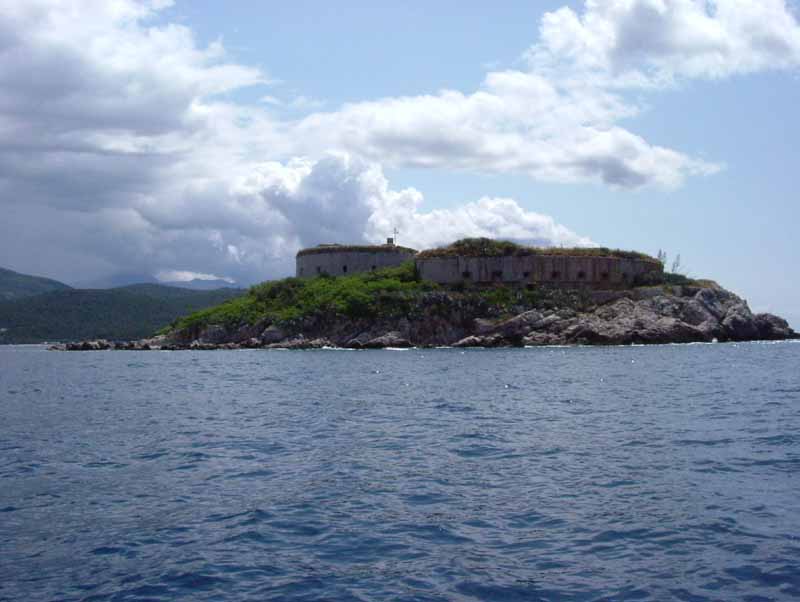
Mamula ( cnr, Мамула), also known colloquially as Lastavica, is an uninhabited islet in the Adriatic Sea, within the southwestern Montenegrin municipality of Herceg Novi. Mamula is located between Prevlaka and Luštica peninsulas at the entrance to the Bay of Kotor. This small islet is of circular shape, and has 200m in diameter. It is away from Herceg Novi. History During the period of the Venetian Republic rule, the island was known as Rondina. The island has a fort, built in 1853 by Austria-Hungary, Austro-Hungarian general Lazarus von Mamula. The fort takes up about 90% of the island's surface area. Along with the fortification on Prevlaka's Cape Oštro as well as Arza fortification on Luštica's Cape Arza, both of which were erected at the same time also on suggestion by general Lazarus von Mamula, fort Mamula was part of the Austro-Hungarian Army's contingency plans of preventing the enemy entrance into the Bay of Kotor The Bay of Kotor ( Montenegrin and Serbian: ... [...More Info...] [...Related Items...] OR: [Wikipedia] [Google] [Baidu] |
Tivat
Tivat (, ) is a coastal town in southwest Montenegro, located in the Bay of Kotor. , its population was 9,367. Tivat is the centre of Tivat Municipality, which is the smallest municipality by area in Montenegro. Name In Serbian and Montenegrin language the town is known as ''Tivat'' (Тиват); in Italian and Venetian as ''Teodo''; the name of the city is derived either from the name of Illyrian Queen Teuta who ruled the region in 3rd Century BC, or from the Greek word "Θείοδος" (''Theiodos'' meaning "way of God"). History According to legend, ''Tivat'' is derived from Illyrian queen Teuta. Teuta had a residence in Rhizon and a summer residence between the church of St. Rocco in Donja Lastva and Seljanovo. The name could also come from the names of old Christian saints: Saint Theodulus, Theodocius or Theodotus. Besides the popular name Theudo, a Latin expression Latus Tiuveti comes from the 16th century. Finally, the name could originate from Celtic word "touto", town ... [...More Info...] [...Related Items...] OR: [Wikipedia] [Google] [Baidu] |
Fort Kabala 3
A fortification is a military construction or building designed for the defense of territories in warfare, and is also used to establish rule in a region during peacetime. The term is derived from Latin ''fortis'' ("strong") and ''facere'' ("to make"). From very early history to modern times, defensive walls have often been necessary for cities to survive in an ever-changing world of invasion and conquest. Some settlements in the Indus Valley civilization were the first small cities to be fortified. In ancient Greece, large stone walls had been built in Mycenaean Greece, such as the ancient site of Mycenae (famous for the huge stone blocks of its 'cyclopean' walls). A Greek '' phrourion'' was a fortified collection of buildings used as a military garrison, and is the equivalent of the Roman castellum or English fortress. These constructions mainly served the purpose of a watch tower, to guard certain roads, passes, and borders. Though smaller than a real fortress, they acted ... [...More Info...] [...Related Items...] OR: [Wikipedia] [Google] [Baidu] |
Adriatic
The Adriatic Sea () is a body of water separating the Italian Peninsula from the Balkans, Balkan Peninsula. The Adriatic is the northernmost arm of the Mediterranean Sea, extending from the Strait of Otranto (where it connects to the Ionian Sea) to the northwest and the Po Valley. The countries with coasts on the Adriatic are Albania, Bosnia and Herzegovina, Croatia, Italy, Montenegro, and Slovenia. The Adriatic contains more than 1,300 islands, mostly located along the Croatian part of its eastern coast. It is divided into three basins, the northern being the shallowest and the southern being the deepest, with a maximum depth of . The Otranto Sill, an underwater ridge, is located at the border between the Adriatic and Ionian Seas. The prevailing currents flow counterclockwise from the Strait of Otranto, along the eastern coast and back to the strait along the western (Italian) coast. Tidal movements in the Adriatic are slight, although acqua alta, larger amplitudes are known to ... [...More Info...] [...Related Items...] OR: [Wikipedia] [Google] [Baidu] |
Steep Coast
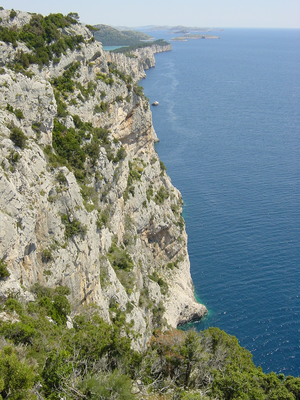
A steep coastBird, Eric (2008). ''Coastal Geomorphology: An Introduction'', 2nd ed., Wiley, Chichester, 2008. is a stretch of coastline where the mainland descends abruptly into the sea. There is a sharp transition from the land to sea as opposed to that on a flat coast where the land descends gradually seawards. The height of the land on a steep coast is well above sea level. Most steep coast are rocky cliffed coasts (also called abrasion coasts), where the erosion processes of wave action result in a steep declivity. Another type of steep coast is the fjord which is formed when a glacial valley lies partially under water as a result of a rise in sea levels. In Norway, New Zealand or Alaska there are fjords whose almost vertical sides tower over 1,000 metres above the water and plunge 300 metres below it. On volcanic islands the sea can enter the caldera and the face of the volcanic pipe can form a steep coastline. The best-known example of that is Santorini in the arc ... [...More Info...] [...Related Items...] OR: [Wikipedia] [Google] [Baidu] |
Arza
Arza (; ) is a small populated town and township, east of Lhasa in the Tibet Autonomous Region of China. It belongs to Lhari County (Jiali Xian) of the Nagqu Prefecture Nagqu (also Naqu, Nakchu, or Nagchu; ; ) is a prefecture-level city in the north of the Chinese autonomous region of Tibet. On May 7, 2018, the former Nagqu Prefecture was officially declared the sixth prefecture-level city in Tibet after Lhasa, .... It also contains solar panels. References Populated places in Nagqu Township-level divisions of Tibet Lhari County {{Nagqu-geo-stub ... [...More Info...] [...Related Items...] OR: [Wikipedia] [Google] [Baidu] |
Austro-Hungarian Navy
The Austro-Hungarian Navy or Imperial and Royal War Navy (german: kaiserliche und königliche Kriegsmarine, in short ''k.u.k. Kriegsmarine'', hu, Császári és Királyi Haditengerészet) was the naval force of Austria-Hungary. Ships of the Austro-Hungarian Navy were designated ''SMS'', for ''Seiner Majestät Schiff'' (His Majesty's Ship). The k.u.k. Kriegsmarine came into being after the formation of Austria-Hungary in 1867, and ceased to exist in 1918 upon the Empire's defeat and subsequent collapse at the end of World War I. Prior to 1867, the Imperial Austrian Navy or simply the Austrian Navy, saw action in the French Revolutionary Wars, the Napoleonic Wars, the Austrian expedition against Morocco (1829), the Second Egyptian–Ottoman War, the First and Second Wars of Italian Independence, the Second Schleswig War, and the Third War of Italian Independence. Following Austria's defeat by Prussia and Italy during the Seven Weeks' War, the Austrian Empire reformed itself i ... [...More Info...] [...Related Items...] OR: [Wikipedia] [Google] [Baidu] |
Austro-Hungarian
Austria-Hungary, often referred to as the Austro-Hungarian Empire,, the Dual Monarchy, or Austria, was a constitutional monarchy and great power in Central Europe between 1867 and 1918. It was formed with the Austro-Hungarian Compromise of 1867 in the aftermath of the Austro-Prussian War and was dissolved shortly after its defeat in the First World War. Austria-Hungary was ruled by the House of Habsburg and constituted the last phase in the constitutional evolution of the Habsburg monarchy. It was a multinational state and one of Europe's major powers at the time. Austria-Hungary was geographically the second-largest country in Europe after the Russian Empire, at and the third-most populous (after Russia and the German Empire). The Empire built up the fourth-largest machine building industry in the world, after the United States, Germany and the United Kingdom. Austria-Hungary also became the world's third-largest manufacturer and exporter of electric home appliances, el ... [...More Info...] [...Related Items...] OR: [Wikipedia] [Google] [Baidu] |
Kotor
Kotor (Montenegrin Cyrillic: Котор, ), historically known as Cattaro (from Italian: ), is a coastal town in Montenegro. It is located in a secluded part of the Bay of Kotor. The city has a population of 13,510 and is the administrative center of Kotor Municipality. The old Mediterranean port of Kotor is surrounded by fortifications built during the Venetian period. It is located on the Bay of Kotor (''Boka Kotorska''), one of the most indented parts of the Adriatic Sea. Some have called it the southernmost fjord in Europe, but it is a ria, a submerged river canyon. Together with the nearly overhanging limestone cliffs of Orjen and Lovćen, Kotor and its surrounding area form an impressive landscape. Since the early 2000s Kotor has seen an increase in tourists, many of them coming by cruise ship. Visitors are attracted by the natural environment of the Gulf of Kotor and by the old town of Kotor. Kotor is part of the World Heritage Site dubbed the Natural and Culturo-Hist ... [...More Info...] [...Related Items...] OR: [Wikipedia] [Google] [Baidu] |


