|
Loch Errochty
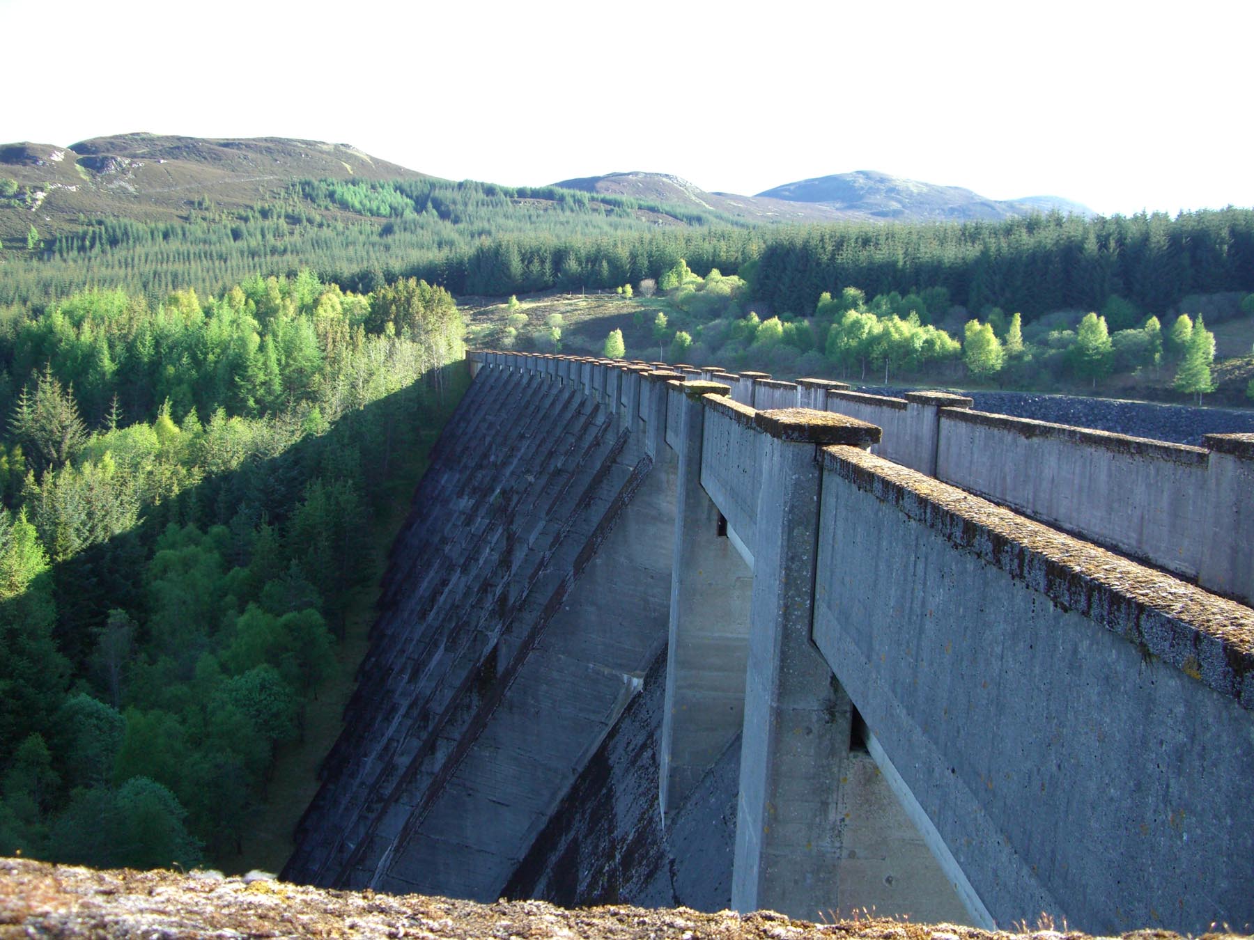
Loch Errochty is a man made freshwater loch situated within the Perth and Kinross council area at the edge of the Scottish Highlands near the Highland Boundary Fault where the topography changes to lowland. Overview The Errochty dam lies at the head of Glen Errochty, two km NW of the hamlet of Trinafour at the approximate grid reference of . The loch has an area of 303 hectareswww.almanacofscotland.co.uk. Gives surface area of loch. and is 5 km long and a kilometre across at its widest point. The loch is entirely man made, being created by the damming of the Errochty Water, the river which runs down the glen. The dam was constructed in 1957 by the contractors A. & M. Carmichael Ltd as part of phase two of the |
Beinn A' Chuallaich
Beinn a' Chuallaich is a Scottish hill, four kilometres northeast of the village of Kinloch Rannoch in the Perth and Kinross council area. It is part of the high ground between Strath Tummel and Glen Errochty. Overview Beinn a’ Chuallaich is a sizeable and extensive hill which can seem quite inconspicuous when viewed from certain places, especially from the south. This is mainly because of the close proximity of the more eye catching and higher Schiehallion which lies seven km to the SE across Dunalastair Water and dominates Strath Tummel. However Beinn a' Chuallaich is well seen from the head of Glen Errochty where it shows its long NE ridge and its craggy eastern corrie. The hill reaches a height of 892 metres (2926 feet) and qualifies as a Corbett and a Marilyn. Etymology The hill's name translates from the Scottish Gaelic language as “Hill of the Herding” and this refers to the fact that it lies on the route of one of the main north-south ancient drovers' roads ... [...More Info...] [...Related Items...] OR: [Wikipedia] [Google] [Baidu] |
Hydroelectricity
Hydroelectricity, or hydroelectric power, is Electricity generation, electricity generated from hydropower (water power). Hydropower supplies one sixth of the world's electricity, almost 4500 TWh in 2020, which is more than all other Renewable energy, renewable sources combined and also more than nuclear power. Hydropower can provide large amounts of Low-carbon power, low-carbon electricity on demand, making it a key element for creating secure and clean electricity supply systems. A hydroelectric power station that has a dam and reservoir is a flexible source, since the amount of electricity produced can be increased or decreased in seconds or minutes in response to varying electricity demand. Once a hydroelectric complex is constructed, it produces no direct waste, and almost always emits considerably less greenhouse gas than fossil fuel-powered energy plants. [...More Info...] [...Related Items...] OR: [Wikipedia] [Google] [Baidu] |
Reservoirs In Perth And Kinross
A reservoir (; from French ''réservoir'' ) is an enlarged lake behind a dam. Such a dam may be either artificial, built to store fresh water or it may be a natural formation. Reservoirs can be created in a number of ways, including controlling a watercourse that drains an existing body of water, interrupting a watercourse to form an embayment within it, through excavation, or building any number of retaining walls or levees. In other contexts, "reservoirs" may refer to storage spaces for various fluids; they may hold liquids or gasses, including hydrocarbons. ''Tank reservoirs'' store these in ground-level, elevated, or buried tanks. Tank reservoirs for water are also called cisterns. Most underground reservoirs are used to store liquids, principally either water or petroleum. Types Dammed valleys Dammed reservoirs are artificial lakes created and controlled by a dam constructed across a valley, and rely on the natural topography to provide most of the basin of the re ... [...More Info...] [...Related Items...] OR: [Wikipedia] [Google] [Baidu] |
Lochs Of Perth And Kinross
''Loch'' () is the Scottish Gaelic, Scots and Irish word for a lake or sea inlet. It is cognate with the Manx lough, Cornish logh, and one of the Welsh words for lake, llwch. In English English and Hiberno-English, the anglicised spelling lough is commonly found in place names; in Lowland Scots and Scottish English, the spelling "loch" is always used. Many loughs are connected to stories of lake-bursts, signifying their mythical origin. Sea-inlet lochs are often called sea lochs or sea loughs. Some such bodies of water could also be called firths, fjords, estuaries, straits or bays. Background This name for a body of water is Insular CelticThe current form has currency in the following languages: Scottish Gaelic, Irish, Manx, and has been borrowed into Lowland Scots, Scottish English, Irish English and Standard English. in origin and is applied to most lakes in Scotland and to many sea inlets in the west and north of Scotland. The word comes from Proto-Indo-Europea ... [...More Info...] [...Related Items...] OR: [Wikipedia] [Google] [Baidu] |
Shieling
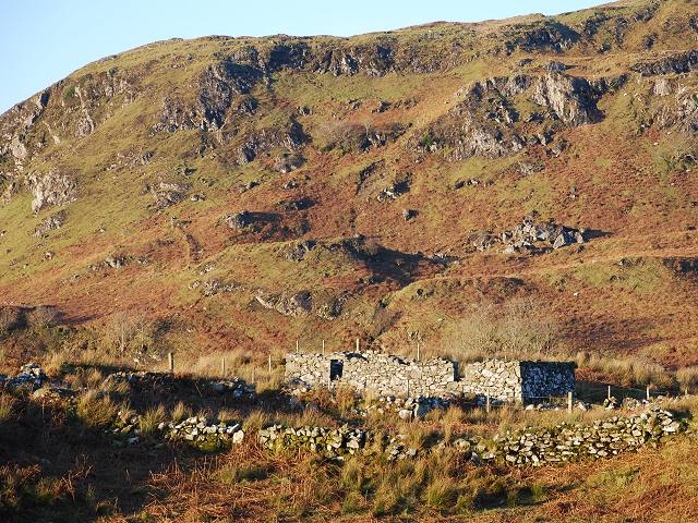
A shieling is a hut or collection of huts on a seasonal pasture high in the hills, once common in wild or sparsely populated places in Scotland. Usually rectangular with a doorway on the south side and few or no windows, they were often constructed of dry stone or turf. More loosely, the term may denote a seasonal mountain pasture for the grazing of cattle in summer. Seasonal pasturage implies transhumance between the shieling and a valley settlement in winter. Many Scottish songs have been written about life in shielings, often concerning courtship and love. The ruins of shielings are abundant landscape features across Scotland, particularly the Highlands. Etymology A "shieling" is a summer dwelling on a seasonal pasture high in the hills. The first recorded use of the term is from 1568. The word "shieling" comes from "shiel", from the forms ''schele'' or ''shale'' in the Northern dialect of Middle English, likely related to Old Frisian ''skul'' meaning "hiding place" and ... [...More Info...] [...Related Items...] OR: [Wikipedia] [Google] [Baidu] |
Fish Ladder
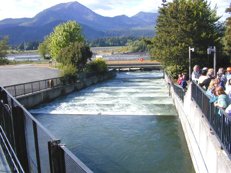
A fish ladder, also known as a fishway, fish pass, fish steps, or fish cannon is a structure on or around artificial and natural barriers (such as dams, locks and waterfalls) to facilitate diadromous fishes' natural migration as well as movements of potamodromous species. Most fishways enable fish to pass around the barriers by swimming and leaping up a series of relatively low steps (hence the term ''ladder'') into the waters on the other side. The velocity of water falling over the steps has to be great enough to attract the fish to the ladder, but it cannot be so great that it washes fish back downstream or exhausts them to the point of inability to continue their journey upriver. History Written reports of rough fishways date to 17th-century France, where bundles of branches were used to make steps in steep channels to bypass obstructions. A pool and weir salmon ladder was built around 1830 by James Smith, a Scottish engineer on the River Teith, near Deanston, Perthshire ... [...More Info...] [...Related Items...] OR: [Wikipedia] [Google] [Baidu] |
Salmon
Salmon () is the common name for several list of commercially important fish species, commercially important species of euryhaline ray-finned fish from the family (biology), family Salmonidae, which are native to tributary, tributaries of the North Atlantic (genus ''Salmo'') and North Pacific (genus ''Oncorhynchus'') basin. Other closely related fish in the same family include trout, Salvelinus, char, Thymallus, grayling, Freshwater whitefish, whitefish, lenok and Hucho, taimen. Salmon are typically fish migration, anadromous: they hatch in the gravel stream bed, beds of shallow fresh water streams, migrate to the ocean as adults and live like sea fish, then return to fresh water to reproduce. However, populations of several species are restricted to fresh water throughout their lives. Folklore has it that the fish return to the exact spot where they hatched to spawn (biology), spawn, and tracking studies have shown this to be mostly true. A portion of a returning salmon run ma ... [...More Info...] [...Related Items...] OR: [Wikipedia] [Google] [Baidu] |
Perch
Perch is a common name for fish of the genus ''Perca'', freshwater gamefish belonging to the family Percidae. The perch, of which three species occur in different geographical areas, lend their name to a large order of vertebrates: the Perciformes, from the el, πέρκη (), simply meaning perch, and the Latin ''forma'' meaning shape. Many species of freshwater gamefish more or less resemble perch, but belong to different genera. In fact, the exclusively saltwater-dwelling red drum is often referred to as a red perch, though by definition perch are freshwater fish. Though many fish are referred to as perch as a common name, to be considered a true perch, the fish must be of the family Percidae. The type species for this genus is the European perch, ''P. fluviatilis''. Species Most authorities recognize three species within the perch genus: * The European perch (''P. fluviatilis'') is primarily found in Europe, but a few can also be found in South Africa, and even as far ea ... [...More Info...] [...Related Items...] OR: [Wikipedia] [Google] [Baidu] |
Esox
''Esox'' is a genus of freshwater fish commonly known as pike or pickerel. It is the type genus of the family Esocidae. The type species of the genus is ''Esox lucius'', the northern pike. ''Esox'' has been present in Laurentia (which later became North America) and Eurasia since the Paleocene. Modern large pike species are native to the Palearctic and Nearctic realms, ranging across Northern America and from Western Europe to Siberia in North Asia. Pikes have the elongated, torpedo-like shape typical of predatory fishes, with sharply pointed heads and sharp teeth. Their coloration is typically grey-green with a mottled or spotted appearance with stripes along their backs, providing camouflage among underwater weeds, and each individual pike marking patterns are unique like fingerprints. Pikes can grow to a maximum recorded length of , reaching a maximum recorded weight of . Etymology The generic name ''Esox'' (pike fish) derives from the Greek ἴσοξ (''ee-soks'', a ... [...More Info...] [...Related Items...] OR: [Wikipedia] [Google] [Baidu] |
Recreational Fishing
Recreational fishing, also called sport fishing or game fishing, is fishing for leisure, exercise or competition. It can be contrasted with commercial fishing, which is professional fishing for profit; or subsistence fishing, which is fishing for survival and livelihood. The most common form of recreational fishing is angling, which is done with a rig of rod, reel, line, hooks and any one of a wide range of baits, as well as other complementary devices such as weights, floats, swivels and method feeders, collectively referred to as '' terminal tackles''. Lures are frequently used in place of fresh bait when fishing for predatory fishes. Some hobbyists hand-make custom tackles themselves, including plastic lures and artificial flies. Other forms of recreational fishing include spearfishing, which is done with a speargun or harpoon usually while diving; and bowfishing, with is done from above the water with archery equipments such as a compound bow or crossbow. Noodl ... [...More Info...] [...Related Items...] OR: [Wikipedia] [Google] [Baidu] |
Catchwater
A catchwater device is a large-scale man-made device for catching surface runoff from hills and the sky from precipitation by channeling it to reservoirs for commercial and domestic use later. Freshwater is a scarce natural resource due to pollution, droughts, and overpopulation. Catchwater is a sustainable mechanism to increase freshwater in areas facing droughts or polluted waterways. Types Catchwater drains Catchwater drains may take the form of concrete canals, such as in Hong Kong, where there are many. Alternatively, they may take the form of a large concrete sheet, smothering a hill, and preventing rainfall from entering the rock strata, with a smaller channeling system for transport of the water to the storage tank - this latter system is in operation in Gibraltar. In Hong Kong there are approximately 120 km of concrete channels, used as gutters built along hillsides in order to direct freshwater runoff into reservoirs for local water consumption. These catchwate ... [...More Info...] [...Related Items...] OR: [Wikipedia] [Google] [Baidu] |
Loch Tummel
Loch Tummel (Scottish Gaelic: Loch Teimheil) is a long, narrow loch, northwest of Pitlochry in the council area of Perth and Kinross, Scotland. It is fed and drained by the River Tummel, which flows into the River Tay about south-east of the Clunie Dam at the loch's eastern end.Ordnance Survey. ''Explorer'' Map 1:25000. Sheet OL49, Pitlochry & Loch Tummel. The loch is traversed by roads to both north and south. Along the northern side the road is numbered as the B8019, and runs from the Pass of Killiecrankie on the A9 in the east to Tummel Bridge at the head of the loch. The road on the southern side is unclassified, and meets the A9 further south, near to Pitlochry. The loch gives its name to the Loch Tummel National Scenic Area (NSA), one of 40 such areas in Scotland, which are defined so as to identify areas of exceptional scenery and to ensure its protection by restricting certain forms of development. The Loch Tummel Lyon NSA covers , all of which lies within Perth and ... [...More Info...] [...Related Items...] OR: [Wikipedia] [Google] [Baidu] |


.png)
_-_Ystad-2018.jpg)

