|
List Of Largest Cities In Brazil By State
North Region Acre *Cruzeiro do Sul, Acre, Cruzeiro do Sul - 86,725 *Rio Branco, Acre, Rio Branco (capital) - 314,127 (Est. 2006 - Brazilian Institute of Geography and Statistics, IBGE) Amapá *Macapá (capital) - 368,367 *Santana, Amapá, Santana - 101,864 (Est. 2006 - Brazilian Institute of Geography and Statistics, IBGE) Amazonas *Coari - 87,468 *Itacoatiara, Amazonas, Itacoatiara - 81,674 *Manacapuru - 84,656 *Manaus (capital) - 1,688,524 *Parintins - 112,636 *Tefé - 71,975 (Est. 2006 - Brazilian Institute of Geography and Statistics, IBGE) Pará *Abaetetuba - 133,316 *Altamira, Pará, Altamira - 85,649 *Ananindeua - 498,095 (part of the Metropolitan Region of Belém) *Barcarena, Brazil, Barcarena - 76,071 *Belém (capital) - 1,428,368 *Bragança, Pará, Bragança - 103,751 *Breves, Pará, Breves - 86,084 *Cametá - 106,816 *Castanhal - 158,462 *Itaituba - 96,515 *Marabá - 200,801 *Marituba - 101,356 (part of the Metropolitan Region of Belém) *Paragominas - 88,877 * ... [...More Info...] [...Related Items...] OR: [Wikipedia] [Google] [Baidu] |
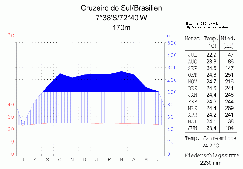
Cruzeiro Do Sul, Acre
) , motto = , image_skyline = Centro de Cruzeiro do Sul-AC.jpg , imagesize = , image_caption = City centre, Catedral Nossa Senhora da Glória, alongside Juruá River, Acre, Brazil. , image_flag = Bandeira de Cruzeiro do Sul (Acre).svg , flag_size = , image_seal = Brasão Cruzeiro do Sul.jpg , seal_size = , image_shield = , shield_size = , image_blank_emblem = , blank_emblem_type = , blank_emblem_size = , image_map = Acre Municip CruzeirodoSul.svg , mapsize = , map_caption = Location in Acre , pushpin_map = Brazil , pushpin_label_position = bottom , pushpin_map_caption = Location in Brazil , subdivision_type = Country , subdivision_name = , subdivision_name1 = North , subdivision_type1 = Region , subdivisi ... [...More Info...] [...Related Items...] OR: [Wikipedia] [Google] [Baidu] |
Breves, Pará
Breves is a Brazilian municipality located in the state of Pará, on the island of Marajó. Its population is estimated to be 103,497 people. The area of the municipality is 9,550.454 km². The city belongs to the mesoregion Marajó and to the microregion of ''Furos de Breves''. The municipality is contained in the Marajó Archipelago Environmental Protection Area, a sustainable use conservation unit established in 1989 to protect the environment of the delta region. It contains the Mapuá Extractive Reserve, a sustainable use conservation unit created in 2005. The city is served by Breves Airport. Climate The climate is tropical rainforest or equatorial (Köppen Köppen is a German surname. Notable people with the surname include: * Bernd Köppen (born 1951), German pianist and composer * Carl Köppen (1833-1907), German military advisor in Meiji era Japan * Edlef Köppen (1893–1939), German author and ...: ''Af'') with high rainfall and high temperature all year ... [...More Info...] [...Related Items...] OR: [Wikipedia] [Google] [Baidu] |
Ji-Paraná
Ji-Paraná is the second most populous municipality in the Brazilian state of Rondônia, with a population of 130,009, and the 16th most populous city of the Brazilian North Region, the 210th most populous city of Brazil, and the 113th of the Brazilian interior. It has an area of 6,897 km2. The city is divided by the Ji-Paraná River. The city economy is industry and dairy production. The city was also the first of Rondônia State to invest in high technology of data transmission, when it connected, through a wireless network, the City Hall. The municipality name comes from tupi, meaning "great river of axes", through the junction of ''yî'' (axe) ''e paranã'' (sea, great river). It is a reference to the great amount of rocks in the river looking like indigenous axes. The municipality is also known as the Heart of Rondônia, due to the central city location and the existence of a heart shaped island, located in the confluence of the Machado and Urupá River. Located in ce ... [...More Info...] [...Related Items...] OR: [Wikipedia] [Google] [Baidu] |
Cacoal
Cacoal is a municipality in the Brazilian state of Rondônia. It has an area of . It has a Tropical savanna climate. As of 2020 the estimated population was 85,893. It is the fourth-largest city in Rondônia state. The city is served by Capital do Café Airport. Geography Cacoal is in the state of Rondônia, Brazil. It has an area of as of 2019. The elevation above sea level is about . History The name of the region dates to the time of Marechal Cândido Rondon, who noticed a large amount of native cocao there near the bank of the Ji-Paraná River (Machado River). He recommended that the guard Anízio Serrão build a house there, and Serrao asked for the site to be granted to him in 1912, calling it Cacoal. The village of Cacoal emerged in the 1960s, when the BR-364 highway began to be opened. In 1960, the rubber tapper and gold miner José Cassimiro Lopes built a shack on the left side of the highway, where he remained until the early 1970s. Work on the road intensified ... [...More Info...] [...Related Items...] OR: [Wikipedia] [Google] [Baidu] |
Ariquemes
Ariquemes is a municipality located in the Brazilian state of Rondônia. Its population was 109,523 (2020 est.) and its area is 4,427 km2. - IBGE The Brazilian Institute of Geography and Statistics ( pt, Instituto Brasileiro de Geografia e Estatística; IBGE) is the agency responsible for official collection of statistical, geographic, cartographic, geodetic and environmental information ... It is the third-largest city in Rondônia state. Transportation The city is served by Ariquemes Airport. References External links * Municipalities in Rondônia {{Rondônia-geo-stub ... [...More Info...] [...Related Items...] OR: [Wikipedia] [Google] [Baidu] |
Tucuruí
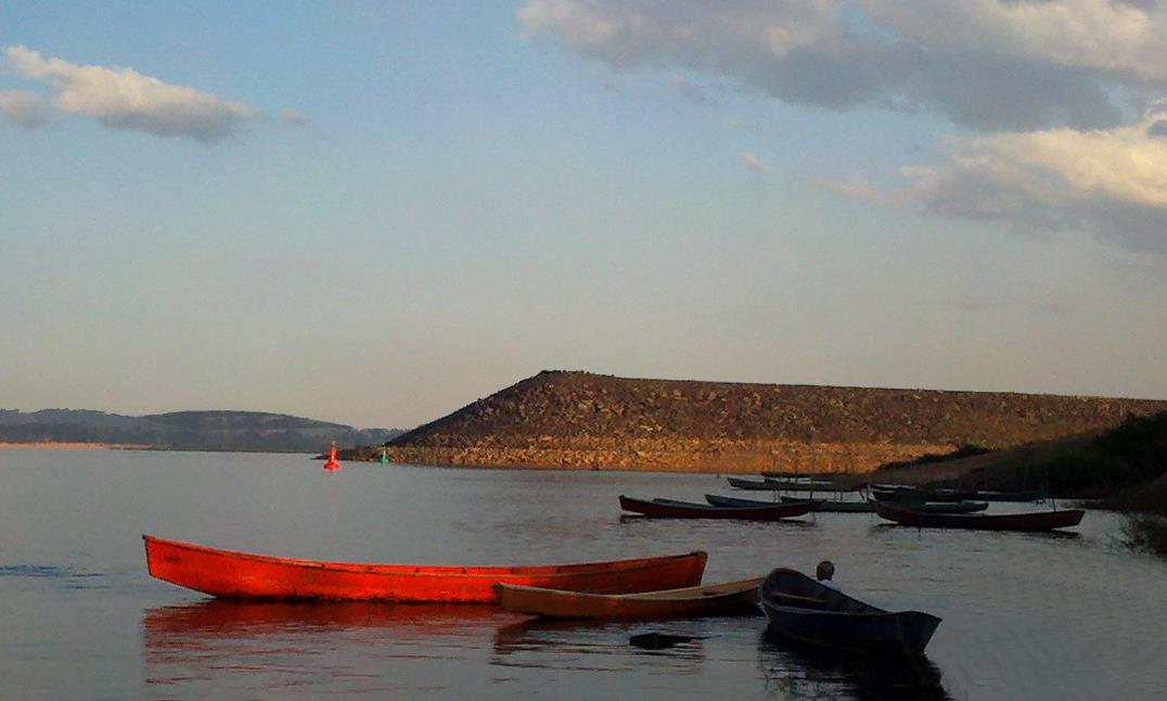
Tucuruí is a municipality in the state of Pará in the Northern region of Brazil. The city is served by Tucuruí Airport. The name Tucuruí is a Tupi word that means "river of ants" or "river of locusts". It's the concatenation of two tupi words: tukura (ants, locusts) and 'y (water). The city is very famous because of its colossal Dam, the Tucuruí Dam which is administered by Eletrobrás Eletronorte – the constructor company of this large infrastructure project. Economy Currently, Tucuruí city's economy is based on agriculture and general commerce. During its 60 years the commerce activity varied a lot. In the beginning there was a railroad for draining out the production of the Brazil Nut (known in Brazil as "Pará's Nut"), a very abundant available product in the region. The Tucuruí Dam developed the municipality and brought large industries for the region. Tourism In Tucuruí, you can explore the dam lake, one of the largest artificial lakes ever made by man. It h ... [...More Info...] [...Related Items...] OR: [Wikipedia] [Google] [Baidu] |
Redenção, Pará
Redenção, Pará is a municipality in the state of Pará in the Northern region of Brazil. The city is served by Redenção Airport. See also *List of municipalities in Pará This is a list of the municipalities in the state of Pará (PA), located in the North Region of Brazil. Pará is divided into 144 municipalities, which are grouped into 22 microregions, which are grouped into 6 mesoregions. [...More Info...] [...Related Items...] OR: [Wikipedia] [Google] [Baidu] |
Parauapebas
Parauapebas is a municipality in the state of Pará in the Northern region of Brazil. Geography To the north is the municipality of Marabá; to the east, Curionópolis; to the south-east, Canaã dos Carajás; to the south, Água Azul do Norte; to the south-west, Ourilândia do Norte, and to the west, São Félix do Xingu. The municipality contains part of the Tapirapé-Aquiri National Forest, a sustainable use conservation unit created in 1989. It contains 68.9% of the Carajás National Forest, a sustainable use conservation unit created in 1998 that includes mining operations in a huge deposit of high-grade iron ore. Carajás Mine is located in the boundaries of the municipality. Transport There are direct road connections with Marabá to the north-east, Curionópolis to the east, and Canaã dos Carajás to the south. One of Brazil's only inter-city rail services (Carajás Railway) is operated by rail freight operator Vale and links São Luís with Parauapeba ... [...More Info...] [...Related Items...] OR: [Wikipedia] [Google] [Baidu] |
Paragominas
Paragominas is a municipality in the state of Pará in the Northern region of Brazil. Paragominas mine, one of the largest bauxite mines in the world, is approximately 70 km away. According to an estimate dated 1 July 2020, the city has a population of 111,764 and is at an altitude of 90 m above sea level. M. With a municipal area of approximately 19,342 km², it has a population density of 5.7 inhabitants per km², approximately the size of the state of Rhineland-Palatinate. Its distance from the capital Belém is 300 km. Since 2011 it has been allowed to call itself Município Verde (Green City or Eco-City). Toponimia The name of the municipality originates from a series of abbreviations for the states of Pará, Goiás and Minas Gerais ("Para-Go-Minas"). History The city was founded in 1965 . Climate The city has a tropical climate according to Köppen-Geiger. The average temperature is 26.6 °C. Average annual precipitation is 1805 mm. A ... [...More Info...] [...Related Items...] OR: [Wikipedia] [Google] [Baidu] |
Marituba
Marituba is a municipality in the state of Pará in the Northern region of Brazil. It is the smallest municipality of Pará and the smallest in all Northern Brazil. See also *List of municipalities in Pará This is a list of the municipalities in the state of Pará (PA), located in the North Region of Brazil. Pará is divided into 144 municipalities, which are grouped into 22 microregions, which are grouped into 6 mesoregions. [...More Info...] [...Related Items...] OR: [Wikipedia] [Google] [Baidu] |


