|
Lechrain
Lechrain is the name of an informally defined region of Germany extending southwards from Augsburg towards the foothills of the Alps along the Lech river, mainly on the east bank. It forms a boundary region between Bavaria and Swabia. The Lechrainer dialect has traces of Middle High German. Geography The name "Lechrain" includes the Old High German "rein", indicating a borderland, in this case between Bavaria and Swabia. It stretches from the foothills of the Alps into the Danube valley. The main settlements are Kempten, Füssen, Kaufbeuren, Peiting, Schongau, Landsberg am Lech, Augsburg, Friedberg, Mering and Donauwörth. History Before the Christian era the land was occupied by Celts, then by Romans and later by Alemanni and Bavarians. Under the Romans it was the province of "Raetia II". In the 8th century it lay on the border between Bavaria and Swabia in the Merovingian and Carolingian periods. It was then occupied by Guelphs, Hohenstaufens and from the 13th century, the ... [...More Info...] [...Related Items...] OR: [Wikipedia] [Google] [Baidu] |
Schongau, Bavaria
Schongau is a town in Bavaria, near the Alps. It is located along the Lech, between Landsberg am Lech and Füssen. It has about 12,000 inhabitants. Schongau has a well-preserved old wall around the center. Local history The origin of Schongau is the current Altenstadt (lit.: old town). A large number of the inhabitants moved only a few kilometres into a new settlement founded on the Lech and took the name Schongau with them in the 13th century. The hillside was far better situated to defend it. The town of Schongau is located very close to the former Roman road to Augsburg, Via Claudia Augusta (47 AD) and has its name from the Romans. In the Middle Ages, it was an important hub and an commercial centre on route Verona-Augsburg-Nuremberg and at salt road from Berchtesgadener Land into the Allgäu. Lechrain, populated by the Alemanni, was under the rule of the Swabian Welfs until the 12 century. After the death of Welf VI in 1191, the Welf territories in Swabia changed in to the ... [...More Info...] [...Related Items...] OR: [Wikipedia] [Google] [Baidu] |
Landsberg Am Lech
Landsberg am Lech (Landsberg at the Lech) is a town in southwest Bavaria, Germany, about 65 kilometers west of Munich and 35 kilometers south of Augsburg. It is the capital of the district of Landsberg am Lech. Overview Landsberg is situated on the Romantic Road and is the center of the Lechrain region, the boundary region between Swabia and Bavaria. It is noted for its picturesque historic center. Landsberg am Lech developed where a major historic salt road crossed over the Lech. To protect the bridge, Duke Henry the Lion ordered a castle to be built, ''Castrum Landespurch'', incorporating an older settlement and castle named ''Phetine''. Soon a greater settlement evolved, which received its town charter as early as the 13th century. In 1315, the town burned down, but was rebuilt because of its important location. In 1320, Landsberg was permitted to collect salt duties, bringing considerable wealth to the town. In 1419, a river tax added a further source of income. The town ... [...More Info...] [...Related Items...] OR: [Wikipedia] [Google] [Baidu] |
Lech (river)
The Lech (, ''Licca'') is a river in Austria and Germany. It is a right tributary of the Danube in length with a drainage basin of . Its average discharge at the mouth is . Its source is located in the Austrian state of Vorarlberg, where the river rises from lake Formarinsee in the Alps at an altitude of . It flows in a north-north-easterly direction and crosses the German border, forming the Lechfall, a waterfall; afterwards the river enters a narrow gorge (the Lechschlucht). Leaving the Alps, it enters the plains of the Allgäu at Füssen at an elevation of in the German state of Bavaria, where it used to be the location of the boundary with Swabia. The river runs through the city of Füssen and through the Forggensee, a man-made lake which is drained in winter. Here, it forms rapids and a waterfall. The river flows further northwards through a region called the Lechrain, and passes the cities of Schongau, Landsberg, Augsburg (where it receives the Wertach) and Rain be ... [...More Info...] [...Related Items...] OR: [Wikipedia] [Google] [Baidu] |
Mering
Mering is a municipality in the district Aichach-Friedberg, in Bavaria, Germany. It is located on the river Paar. First mentioned in records in 1021, Mering has a long history. The growing town with its nearly 15,000 inhabitants (2021) profits from its good location between Munich and Augsburg. Engine of this growing popularity is the main railway station which connects Mering directly within 30 minutes to Munich and within 15 minutes to Augsburg. Although it profits from being in easy reach of big cities, one can easily get anything in Mering, from ice cream to cars. Mering is a lovely small town with many shopping facilities within easy walking distance. Its motto is "Ihr Einkaufsort der kurzen Wege" (Your shopping centre of short distances). Worth a visit is the baroque main Catholic church St. Michael built in 1789 with its magnificent building and interior. A popular place is the recently redesigned main square (Marktplatz) with shops and restaurants in ancient buildings sur ... [...More Info...] [...Related Items...] OR: [Wikipedia] [Google] [Baidu] |
Hohenstaufens
The Hohenstaufen dynasty (, , ), also known as the Staufer, was a noble family of unclear origin that rose to rule the Duchy of Swabia from 1079, and to royal rule in the Holy Roman Empire during the Middle Ages from 1138 until 1254. The dynasty's most prominent rulers – Frederick I (1155), Henry VI (1191) and Frederick II (1220) – ascended the imperial throne and also reigned over Italy and Burgundy. The non-contemporary name of 'Hohenstaufen' is derived from the family's Hohenstaufen Castle on the Hohenstaufen mountain at the northern fringes of the Swabian Jura, near the town of Göppingen. Under Hohenstaufen rule, the Holy Roman Empire reached its greatest territorial extent from 1155 to 1268. Name The name Hohenstaufen was first used in the 14th century to distinguish the 'high' (''hohen'') conical hill named Staufen in the Swabian Jura (in the district of Göppingen) from the village of the same name in the valley below. The new name was only applied to the hill ca ... [...More Info...] [...Related Items...] OR: [Wikipedia] [Google] [Baidu] |
Guelphs
The Guelphs and Ghibellines (, , ; it, guelfi e ghibellini ) were factions supporting the Pope and the Holy Roman Emperor, respectively, in the Italian city-states of Central Italy and Northern Italy. During the 12th and 13th centuries, rivalry between these two parties formed a particularly important aspect of the internal politics of medieval Italy. The struggle for power between the Papacy and the Holy Roman Empire arose with the Investiture Controversy, which began in 1075, and ended with the Concordat of Worms in 1122. History Origins The Guelph vs Ghibelline conflict initially arose from the division caused by the Investiture Controversy, about whether secular rulers or the pope had the authority to appoint bishops and abbots. Upon the death of Emperor Henry V, of the Salian dynasty, the dukes elected an opponent of his dynasty, Lothair III, as the new emperor. This displeased the Hohenstaufen, who were allied with and related to the old dynasty. Out of fear of the Hoh ... [...More Info...] [...Related Items...] OR: [Wikipedia] [Google] [Baidu] |
Carolingian
The Carolingian dynasty (; known variously as the Carlovingians, Carolingus, Carolings, Karolinger or Karlings) was a Frankish noble family named after Charlemagne, grandson of mayor Charles Martel and a descendant of the Arnulfing and Pippinid clans of the 7th century AD. The dynasty consolidated its power in the 8th century, eventually making the offices of mayor of the palace and '' dux et princeps Francorum'' hereditary, and becoming the ''de facto'' rulers of the Franks as the real powers behind the Merovingian throne. In 751 the Merovingian dynasty which had ruled the Germanic Franks was overthrown with the consent of the Papacy and the aristocracy, and Pepin the Short, son of Martel, was crowned King of the Franks. The Carolingian dynasty reached its peak in 800 with the crowning of Charlemagne as the first Emperor of the Romans in the West in over three centuries. His death in 814 began an extended period of fragmentation of the Carolingian Empire and decline that w ... [...More Info...] [...Related Items...] OR: [Wikipedia] [Google] [Baidu] |
Merovingian
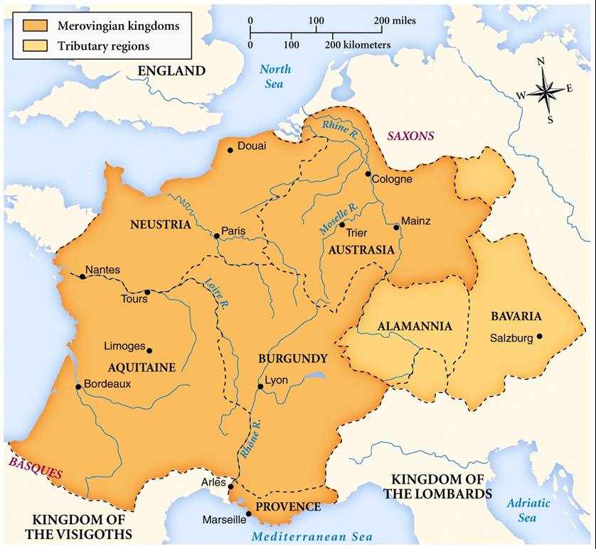
The Merovingian dynasty () was the ruling family of the Franks from the middle of the 5th century until 751. They first appear as "Kings of the Franks" in the Roman army of northern Gaul. By 509 they had united all the Franks and northern Gaulish Romans under their rule. They conquered most of Gaul, defeating the Visigoths (507) and the Burgundians (534), and also extended their rule into Raetia (537). In Germania, the Alemanni, Bavarii and Saxons accepted their lordship. The Merovingian realm was the largest and most powerful of the states of western Europe following the breaking up of the empire of Theodoric the Great. The dynastic name, medieval Latin or ("sons of Merovech"), derives from an unattested Frankish form, akin to the attested Old English , with the final -''ing'' being a typical Germanic patronymic suffix. The name derives from King Merovech, whom many legends surround. Unlike the Anglo-Saxon royal genealogies, the Merovingians never claimed descent from a ... [...More Info...] [...Related Items...] OR: [Wikipedia] [Google] [Baidu] |
Donauwörth
Donauwörth () is a town and the capital of the Donau-Ries district in Swabia, Bavaria, Germany. It is said to have been founded by two fishermen where the rivers Danube (Donau) and Wörnitz meet. The city is part of the scenic route called "Romantische Straße" (Romantic Road). The city is situated between Munich and Nuremberg, 46 km north of Augsburg. History Donauwörth grew up in the course of the 11th and 12th centuries under the protection of the castle of Mangoldstein, became in the 13th century a seat of Duke Ludwig II of Bavaria, who, however, soon withdrew to Munich to escape from his wife, Duchess Maria of Brabant, whom he had there beheaded on an unfounded suspicion of infidelity. The town received the freedom of the Holy Roman Empire in 1308, and maintained its position in spite of the encroachments of Bavaria till 1607, when the interference of the Protestant inhabitants with the abbot of the Heilig-Kreuz called forth an imperial law authorizing the duke of Bav ... [...More Info...] [...Related Items...] OR: [Wikipedia] [Google] [Baidu] |
Augsburg
Augsburg (; bar , Augschburg , links=https://en.wikipedia.org/wiki/Swabian_German , label=Swabian German, , ) is a city in Swabia, Bavaria, Germany, around west of Bavarian capital Munich. It is a university town and regional seat of the ''Regierungsbezirk'' Schwaben with an impressive Altstadt (historical city centre). Augsburg is an urban district and home to the institutions of the Landkreis Augsburg. It is the third-largest city in Bavaria (after Munich and Nuremberg) with a population of 300,000 inhabitants, with 885,000 in its metropolitan area. After Neuss, Trier, Cologne and Xanten, Augsburg is one of Germany's oldest cities, founded in 15 BC by the Romans as Augsburg#Early history, Augusta Vindelicorum, named after the Roman emperor Augustus. It was a Free Imperial City from 1276 to 1803 and the home of the patrician (post-Roman Europe), patrician Fugger and Welser families that dominated European banking in the 16th century. According to Behringer, in the sixteen ... [...More Info...] [...Related Items...] OR: [Wikipedia] [Google] [Baidu] |
Friedberg, Bavaria
Friedberg () is a town in the district Aichach-Friedberg, Bavaria, Germany, with some 30,000 inhabitants. It is located next to Augsburg at the river Lech. The town was founded in the 13th century in order to collect a toll from people using the bridge across the Lech. The town lies almost entirely on the western edge of the hills along the Lechleite, where the river Lech has formed a wide bed from glacial melt water. History Settlements in the area of Friedberg can be traced to Roman times through archeological findings of pottery and brickworks in the Hügelshart, Rohrbach (dating from the last third of the 3rd Century AD), Stätzling (late 3rd Century to 4th Century AD) and Wulfertshausen districts. The town is mentioned in historical documents for the first time in letter of protection from Conrad of the House of Hohenstaufen together with Duke Ludwig II, also called ''"the Strict"'', of Bavaria and the Burghers of Augsburg, in 1264. The ''Fridberch'' castle was subsequen ... [...More Info...] [...Related Items...] OR: [Wikipedia] [Google] [Baidu] |
Peiting
Peiting is a municipality in the Weilheim-Schongau district, in Bavaria, Germany. It is situated on the right bank of the Lech, 3 km southeast of Schongau, and 17 km west of Weilheim in Oberbayern. Transport The municipality has two railway stations, and . Both are located on the Schongau–Peißenberg line. Notable people * Placidus Braun Placidus Braun, (11 February 1756 in Peiting near Schongau, Upper Bavaria – 23 October 1829 in Augsburg, Germany) was a Bavarian Benedictine priest, historian and archivist. Biography At thirteen he went as a choir-boy of the Benedictin ..., Benedictine priest, historian and archivist * Martin Echtler, ski mountaineer References Weilheim-Schongau {{WeilheimSchongau-geo-stub ... [...More Info...] [...Related Items...] OR: [Wikipedia] [Google] [Baidu] |

_-_geo.hlipp.de_-_37358.jpg)

.jpg)


