|
Lampeter-Strasburg School District
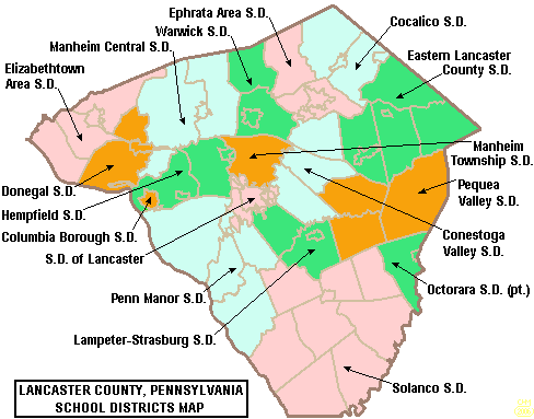
The Lampeter-Strasburg School District is a school district in rural and suburban Lancaster County, Pennsylvania, United States, that serves the borough of Strasburg, Pennsylvania, Strasburg, as well as Strasburg Township, Pennsylvania, Strasburg and West Lampeter Township, Pennsylvania, West Lampeter Townships. The census-designated place of Willow Street, Pennsylvania, Willow Street is mostly in the district. The district operates four schools on its campus, serves approximately 3,000 attending students, and is overseen by its nine-member school board led by president Melissa Herr. Schools The Lampeter-Strasburg School District includes Lampeter-Strasburg High School, Martin Meylin Middle School, Hans Herr Elementary School, and Lampeter Elementary School. All four buildings are on the district's campus in West Lampeter Township. Previously, the district operated Willow Street Elementary School and Strasburg Elementary School, which closed in 2008 and 2013 respectively. Athl ... [...More Info...] [...Related Items...] OR: [Wikipedia] [Google] [Baidu] |
Lancaster County, Pennsylvania
Lancaster County (; Pennsylvania Dutch: Lengeschder Kaundi), sometimes nicknamed the Garden Spot of America or Pennsylvania Dutch Country, is a county in the Commonwealth of Pennsylvania. It is located in the south central part of Pennsylvania. As of the 2020 census, the population was 552,984. Its county seat is Lancaster. Lancaster County comprises the Lancaster, Pennsylvania metropolitan statistical area. Lancaster County is a tourist destination with its Amish community a major attraction. Contrary to popular belief, the word "Dutch" in "Pennsylvania Dutch" is not a mistranslation, but rather a corruption of the Pennsylvania German endonym ''Deitsch'', which means "Pennsylvania Dutch / German" or "German". Ultimately, the terms Deitsch, Dutch, Diets, and Deutsch are all cognates of the Proto-Germanic word meaning "popular" or "of the people". The continued use of "Dutch" instead of "German" was strengthened by the Pennsylvania Dutch in the 19th century as a way of distin ... [...More Info...] [...Related Items...] OR: [Wikipedia] [Google] [Baidu] |
Pennsylvania
Pennsylvania (; ( Pennsylvania Dutch: )), officially the Commonwealth of Pennsylvania, is a state spanning the Mid-Atlantic, Northeastern, Appalachian, and Great Lakes regions of the United States. It borders Delaware to its southeast, Maryland to its south, West Virginia to its southwest, Ohio to its west, Lake Erie and the Canadian province of Ontario to its northwest, New York to its north, and the Delaware River and New Jersey to its east. Pennsylvania is the fifth-most populous state in the nation with over 13 million residents as of 2020. It is the 33rd-largest state by area and ranks ninth among all states in population density. The southeastern Delaware Valley metropolitan area comprises and surrounds Philadelphia, the state's largest and nation's sixth most populous city. Another 2.37 million reside in Greater Pittsburgh in the southwest, centered around Pittsburgh, the state's second-largest and Western Pennsylvania's largest city. The state's su ... [...More Info...] [...Related Items...] OR: [Wikipedia] [Google] [Baidu] |
Map Of Lancaster County Pennsylvania School Districts
A map is a symbolic depiction emphasizing relationships between elements of some space, such as objects, regions, or themes. Many maps are static, fixed to paper or some other durable medium, while others are dynamic or interactive. Although most commonly used to depict geography, maps may represent any space, real or fictional, without regard to context or scale, such as in brain mapping, DNA mapping, or computer network topology mapping. The space being mapped may be two dimensional, such as the surface of the earth, three dimensional, such as the interior of the earth, or even more abstract spaces of any dimension, such as arise in modeling phenomena having many independent variables. Although the earliest maps known are of the heavens, geographic maps of territory have a very long tradition and exist from ancient times. The word "map" comes from the , wherein ''mappa'' meant 'napkin' or 'cloth' and ''mundi'' 'the world'. Thus, "map" became a shortened term referring to ... [...More Info...] [...Related Items...] OR: [Wikipedia] [Google] [Baidu] |
School District
A school district is a special-purpose district that operates local public primary and secondary schools in various nations. North America United States In the U.S, most K–12 public schools function as units of local school districts, which usually operate several schools, and the largest urban and suburban districts operate hundreds of schools. While practice varies significantly by state (and in some cases, within a state), most American school districts operate as independent local governmental units under a grant of authority and within geographic limits created by state law. The executive and legislative power over locally controlled policies and operations of an independent school district are, in most cases, held by a school district's board of education. Depending on state law, members of a local board of education (often referred to informally as a school board) may be elected, appointed by a political office holder, serve ex officio, or a combination of any of ... [...More Info...] [...Related Items...] OR: [Wikipedia] [Google] [Baidu] |

