|
Lake Kariba
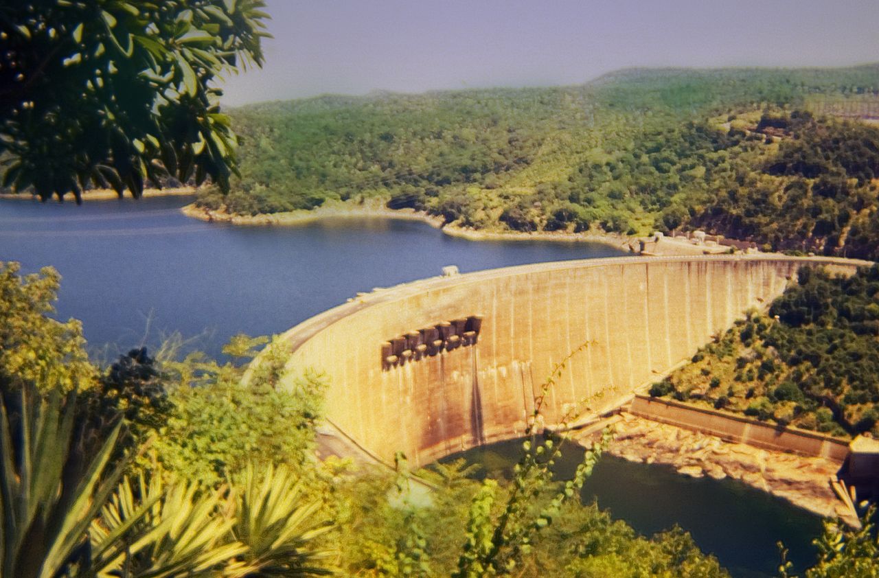
Lake Kariba is the world's largest artificial lake and reservoir (water), reservoir by List of lakes by volume, volume. It lies upstream from the Indian Ocean, along the border between Zambia and Zimbabwe. Lake Kariba was filled between 1958 and 1963 following the completion of the Kariba Dam at its northeastern end, flooding the Kariba Gorge on the Zambezi River. The Zimbabwean town of Kariba, Zimbabwe, Kariba was built for construction workers on the lake's dam, while some other settlements such as Binga village and Mlibizi in Zimbabwe and Siavonga and Sinazongwe in Zambia have grown up to house people displaced by the rising waters. Physical characteristics Lake Kariba is over long and up to in width. It covers an area of and its storage capacity is . The mean depth of the lake is ; the maximum depth is . It is the world's largest man-made reservoir by volume, four times as large as the Three Gorges Dam. The enormous mass of water (approximately 180,000,000,000,000 kilogra ... [...More Info...] [...Related Items...] OR: [Wikipedia] [Google] [Baidu] |
Hydroelectricity
Hydroelectricity, or hydroelectric power, is Electricity generation, electricity generated from hydropower (water power). Hydropower supplies one sixth of the world's electricity, almost 4500 TWh in 2020, which is more than all other Renewable energy, renewable sources combined and also more than nuclear power. Hydropower can provide large amounts of Low-carbon power, low-carbon electricity on demand, making it a key element for creating secure and clean electricity supply systems. A hydroelectric power station that has a dam and reservoir is a flexible source, since the amount of electricity produced can be increased or decreased in seconds or minutes in response to varying electricity demand. Once a hydroelectric complex is constructed, it produces no direct waste, and almost always emits considerably less greenhouse gas than fossil fuel-powered energy plants. [...More Info...] [...Related Items...] OR: [Wikipedia] [Google] [Baidu] |
Siavonga
Siavonga is a town in the Southern Province of Zambia, lying on the north shore of Lake Kariba. It is Zambia's principal tourism centre for the lake, with accommodation, boating and fishing tours on offer. History Tongas are found in this region, the are one of the Bantu Botatwe-speaking people. They have settled in this region for many years and they are the major tribe living on the shore of Lake Kariba. The Tonga people of Zambia and Zimbabwe (also called 'Batonga') are a Bantu ethnic group of southern Zambia and neighbouring northern Zimbabwe, and to a lesser extent, in Mozambique. They are related to the Batoka who are part of the Tokaleya people in the same area. Mining Mutanga Uranium Project 31km North of Siavonga and north of Lake Kariba, there are 5 main Uranium Deposits: Mutanga, Dibwe, Dibwe East, Njame, and Gwabe explored under The Mutanga Uranium Project. The Canadian Toronto Stock Exchange The Toronto Stock Exchange (TSX; french: Bourse de Toronto) is ... [...More Info...] [...Related Items...] OR: [Wikipedia] [Google] [Baidu] |
Bed Island
A bed is an item of furniture that is used as a place to sleep, rest, and relax. Most modern beds consist of a soft, cushioned mattress on a bed frame. The mattress rests either on a solid base, often wood slats, or a sprung base. Many beds include a box spring inner-sprung base, which is a large mattress-sized box containing wood and springs that provide additional support and suspension for the mattress. Beds are available in many sizes, ranging from infant-sized bassinets and cribs, to small beds for a single person or adult, to large queen and king-size beds designed for two people. While most beds are single mattresses on a fixed frame, there are other varieties, such as the murphy bed, which folds into a wall, the sofa bed, which folds out of a sofa, the trundle bed, which is stored under a low, twin-sized bed and can be rolled out to create a larger sleeping area, and the bunk bed, which provides two mattresses on two tiers as well as a ladder to access the upper tie ... [...More Info...] [...Related Items...] OR: [Wikipedia] [Google] [Baidu] |
Fothergill Island '', a plant genus
{{disambig ...
Fothergill may refer to: * Fothergill, Cumbria, a place in England * Fothergill (surname), people with the surname ''Fothergill'' See also * Fothergill gold medal, awarded triennially by the Medical Society of London. * Fothergill medal, previously awarded by the Royal Humane Society. * Fothergill-Round Medal, a Victoria Football League award that is presented to the most promising young talent. * Fothergill's sign, a medical sign *Fothergill island, an island in Lake Kariba * Milner-Fothergill gold medal, awarded by the University of Edinburgh for contribution to therapeutics. * ''Fothergilla ''Fothergilla'' (witch alder) is a genus of two to four species of flowering plants in the family Hamamelidaceae, native to woodland and swamps of the southeastern United States. They are low-growing deciduous shrubs growing to tall with downy ... [...More Info...] [...Related Items...] OR: [Wikipedia] [Google] [Baidu] |
Sampa Karuma
__NOTOC__ The Speech Assessment Methods Phonetic Alphabet (SAMPA) is a computer-readable phonetic script using 7-bit printable ASCII characters, based on the International Phonetic Alphabet (IPA). It was originally developed in the late 1980s for six European languages by the EEC ESPRIT information technology research and development program. As many symbols as possible have been taken over from the IPA; where this is not possible, other signs that are available are used, e.g. @.html" ;"title="code>@">code>@for schwa (IPA ), 2.html" ;"title="code>2">code>2for the vowel sound found in French ''deux'' (IPA ), and 9.html" ;"title="code>9">code>9for the vowel sound found in French ''neuf'' (IPA ). Today, officially, SAMPA has been developed for all the sounds of the following languages: The characters "s{mp@.html" ;"title="code>"s{mp@">code>"s{mp@represent the pronunciation of the name SAMPA in English, with the initial symbol indicating primary stress. Like IPA, SAMPA is usual ... [...More Info...] [...Related Items...] OR: [Wikipedia] [Google] [Baidu] |
Island
An island (or isle) is an isolated piece of habitat that is surrounded by a dramatically different habitat, such as water. Very small islands such as emergent land features on atolls can be called islets, skerries, cays or keys. An island in a river or a lake island may be called an eyot or ait, and a small island off the coast may be called a holm. Sedimentary islands in the Ganges delta are called chars. A grouping of geographically or geologically related islands, such as the Philippines, is referred to as an archipelago. There are two main types of islands in the sea: continental and oceanic. There are also artificial islands, which are man-made. Etymology The word ''island'' derives from Middle English ''iland'', from Old English ''igland'' (from ''ig'' or ''ieg'', similarly meaning 'island' when used independently, and -land carrying its contemporary meaning; cf. Dutch ''eiland'' ("island"), German ''Eiland'' ("small island")). However, the spelling of the word ... [...More Info...] [...Related Items...] OR: [Wikipedia] [Google] [Baidu] |
Richter Magnitude Scale
The Richter scale —also called the Richter magnitude scale, Richter's magnitude scale, and the Gutenberg–Richter scale—is a measure of the strength of earthquakes, developed by Charles Francis Richter and presented in his landmark 1935 paper, where he called it the "magnitude scale". This was later revised and renamed the local magnitude scale, denoted as ML or . Because of various shortcomings of the original scale, most seismological authorities now use other similar scales such as the moment magnitude scale () to report earthquake magnitudes, but much of the news media still erroneously refers to these as "Richter" magnitudes. All magnitude scales retain the logarithmic character of the original and are scaled to have roughly comparable numeric values (typically in the middle of the scale). Due to the variance in earthquakes, it is essential to understand the Richter scale uses logarithms simply to make the measurements manageable (i.e., a magnitude 3 quake factors ... [...More Info...] [...Related Items...] OR: [Wikipedia] [Google] [Baidu] |
Earthquake
An earthquake (also known as a quake, tremor or temblor) is the shaking of the surface of the Earth resulting from a sudden release of energy in the Earth's lithosphere that creates seismic waves. Earthquakes can range in intensity, from those that are so weak that they cannot be felt, to those violent enough to propel objects and people into the air, damage critical infrastructure, and wreak destruction across entire cities. The seismic activity of an area is the frequency, type, and size of earthquakes experienced over a particular time period. The seismicity at a particular location in the Earth is the average rate of seismic energy release per unit volume. The word ''tremor'' is also used for Episodic tremor and slip, non-earthquake seismic rumbling. At the Earth's surface, earthquakes manifest themselves by shaking and displacing or disrupting the ground. When the epicenter of a large earthquake is located offshore, the seabed may be displaced sufficiently to cause ... [...More Info...] [...Related Items...] OR: [Wikipedia] [Google] [Baidu] |
Induced Seismicity
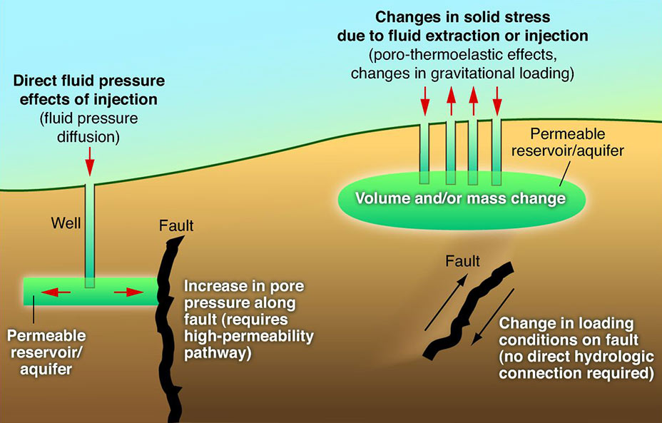
Induced seismicity is typically minor earthquakes and tremors that are caused by human activity that alters the stresses and strains on Earth's crust. Most induced seismicity is of a low magnitude. A few sites regularly have larger quakes, such as The Geysers geothermal plant in California which averaged two M4 events and 15 M3 events every year from 2004 to 2009. The Human-Induced Earthquake Database (''HiQuake'') documents all reported cases of induced seismicity proposed on scientific grounds and is the most complete compilation of its kind. Results of ongoing multi-year research on induced earthquakes by the United States Geological Survey (USGS) published in 2015 suggested that most of the significant earthquakes in Oklahoma, such as the 1952 magnitude 5.7 El Reno earthquake may have been induced by deep injection of waste water by the oil industry. A huge number of seismic events in fracking states like Oklahoma caused by increasing the volume of injection. "Earthquake rate ... [...More Info...] [...Related Items...] OR: [Wikipedia] [Google] [Baidu] |


.jpg)


