|
Lake Asal (Djibouti)
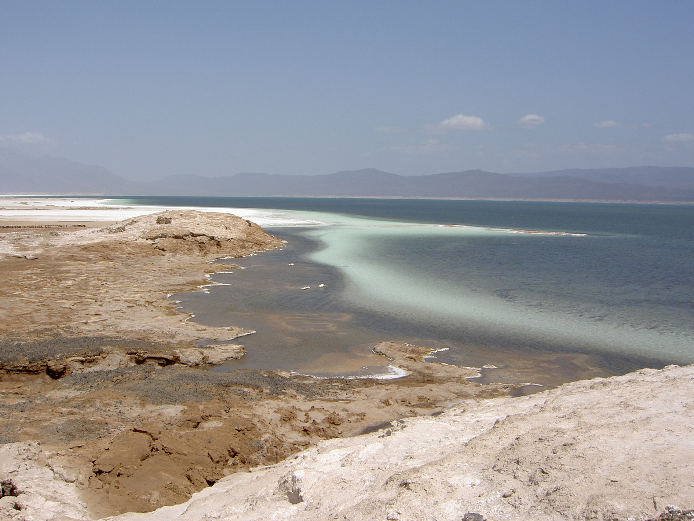
Lake Assal ( ar, بحيرة عسل , lit. “Honey Lake”) is a crater lake in central-western Djibouti. It is located at the western end of Gulf of Tadjoura between Arta Region, and Tadjoura Region, touching Dikhil Region, at the top of the Great Rift Valley, some west of Djibouti city. Lake Assal is a saline lake that lies below sea level in the Afar Triangle, making it the lowest point on land in Africa and the third-lowest point on Earth after the Sea of Galilee and the Dead Sea. No outflow occurs from the lake, and due to high evaporation, the salinity level of its waters is 10 times that of the sea, making it the third most saline body of water in the world behind Don Juan Pond and Gaet'ale Pond. The salt in the lake is exploited under four concessions awarded in 2002 at the southeast end of the lake; the major share of production (nearly 80%) is held by Société d’Exploitation du Lac and Société d’Exploitation du Salt Investment S.A de Djibouti. The lake is ... [...More Info...] [...Related Items...] OR: [Wikipedia] [Google] [Baidu] |
Tadjourah Region
The Tadjourah Region so, Gobolka Tajoora, aa, Rakaakay Tagórri) is a region in north-central Djibouti, the largest of its six regions. With its capital at Tadjourah, it has an area of 7,100 square kilometres (2,700 sq mi). It lies along the Gulf of Tadjoura, and the coastal city of Tadjoura. The region has active salt and fisheries industries, and is served by the Tadjoura Airport. In total area, it is larger than Brunei and smaller than Cyprus. History The boundaries of the present-day Djibouti nation state were established during the Scramble for Africa. The first French establishment in the Horn of Africa, and in 1884 they sign a treaty with the Afar. The poet Arthur Rimbaud became a trader, and lived in Tadjoura from 1885 to 1886. He was the owner of a particular ship carrying weapons to be sold to the King of Shoa, cousin of the father of future Ethiopian Emperor Haile Selassie. In 1883 the French Somaliland (french: Côte française des Somalis) was officially fou ... [...More Info...] [...Related Items...] OR: [Wikipedia] [Google] [Baidu] |
List Of Bodies Of Water By Salinity
__NOTOC__ This is a list of bodies of water by salinity that is limited to natural bodies of water that have a stable salinity above 0.05%, at or below which water is considered freshwater, fresh. Water salinity often varies by location and season, particularly with hypersaline lakes in arid areas, so the salinity figures in the table below should be interpreted as an approximate indicator. See also *List of brackish bodies of water References Notes Bibliography * {{cite book, author1=Johanna Laybourn-Parry, author2=Jemma L. Wadham, title=Antarctic Lakes, url=https://books.google.com/books?id=vHQVDAAAQBAJ&pg=PA92, year=2014, publisher=Oxford University Press, isbn=978-0-19-967049-9, pages=92–94 Lists of bodies of water, Salinity Oceans Saline water ... [...More Info...] [...Related Items...] OR: [Wikipedia] [Google] [Baidu] |
Coal
Coal is a combustible black or brownish-black sedimentary rock, formed as rock strata called coal seams. Coal is mostly carbon with variable amounts of other elements, chiefly hydrogen, sulfur, oxygen, and nitrogen. Coal is formed when dead plant matter decays into peat and is converted into coal by the heat and pressure of deep burial over millions of years. Vast deposits of coal originate in former wetlands called coal forests that covered much of the Earth's tropical land areas during the late Carboniferous ( Pennsylvanian) and Permian times. Many significant coal deposits are younger than this and originate from the Mesozoic and Cenozoic eras. Coal is used primarily as a fuel. While coal has been known and used for thousands of years, its usage was limited until the Industrial Revolution. With the invention of the steam engine, coal consumption increased. In 2020, coal supplied about a quarter of the world's primary energy and over a third of its electricity. Some iron ... [...More Info...] [...Related Items...] OR: [Wikipedia] [Google] [Baidu] |
Sorghum
''Sorghum'' () is a genus of about 25 species of flowering plants in the grass family (Poaceae). Some of these species are grown as cereals for human consumption and some in pastures for animals. One species is grown for grain, while many others are used as fodder plants, either cultivated in warm climates worldwide or naturalized in pasture lands. Taxonomy ''Sorghum'' is in the Poaceae (grass) subfamily Panicoideae and the tribe Andropogoneae (the same as maize, big bluestem and sugarcane). Species Accepted species recorded include: Distribution and habitat Seventeen of the 25 species are native to Australia, with the range of some extending to Africa, Asia, Mesoamerica, and certain islands in the Indian and Pacific Oceans. Toxicity In the early stages of the plants' growth, some species of sorghum can contain levels of hydrogen cyanide, hordenine, and nitrates, which are lethal to grazing animals. Plants stressed by drought or heat can also contain toxic lev ... [...More Info...] [...Related Items...] OR: [Wikipedia] [Google] [Baidu] |
Issa (clan)
The Issa (also Eesah, Esa, Aysa) ( so, Ciise, '', ar, عيسى)'' is a northern Somali clan, a sub-division of the Dir clan family.' Overview As a Dir sub-clan, the Issa have immediate lineal ties with the Gadabuursi, the Surre (Abdalle and Qubeys), the Biimaal (who the Gaadsen also belong to), the Bajimal, the Bursuk, the Madigan Dir, the Gurgura, the Garre (the Quranyow sub-clan to be precise as they claim descent from Dir), Gurre, Gariire, other Dir sub-clans and they have lineal ties with the Hawiye (Irir), Hawadle, Ajuran, Degoodi, Gaalje'el clan groups, who share the same ancestor Samaale.The Quranyo section of the Garre claim descent from Dirr, who are born of the Irrir Samal. UNDP Paper in Kenya http://www.undp.org/content/dam/kenya/docs/Amani%20Papers/AP_Volume1_n2_May2010.pdf For the treaty between the Issa and colonial powers, see "treaties". History The Issa clan has produced numerous noble Somali men and women over the centuries, consisted of a King ... [...More Info...] [...Related Items...] OR: [Wikipedia] [Google] [Baidu] |
Afar People
The Afar ( aa, Qafár), also known as the Danakil, Adali and Odali, are a Cushitic-speaking ethnic group inhabiting the Horn of Africa. They primarily live in the Afar Region of Ethiopia and in northern Djibouti, as well as the entire southern coast of Eritrea. The Afar speak the Afar language, which is part of the Cushitic branch of the Afroasiatic family. Afars are the only inhabitants of the Horn of Africa whose traditional territories border both the Red Sea and the Gulf of Aden. History Early history The earliest surviving written mention of the Afar is from the 13th-century Andalusian writer Ibn Sa'id, who reported that they inhabited the area around the port of Suakin, as far south as Mandeb, near Zeila. They are mentioned intermittently in Ethiopian records, first as helping Emperor Amda Seyon in a campaign beyond the Awash River, then over a century later when they assisted Emperor Baeda Maryam when he campaigned against their neighbors the Dobe'a. According ... [...More Info...] [...Related Items...] OR: [Wikipedia] [Google] [Baidu] |
Tonne
The tonne ( or ; symbol: t) is a unit of mass equal to 1000 kilograms. It is a non-SI unit accepted for use with SI. It is also referred to as a metric ton to distinguish it from the non-metric units of the short ton ( United States customary units), and the long ton ( British imperial units). It is equivalent to approximately 2204.6 pounds, 1.102 short tons, and 0.984 long tons. The official SI unit is the megagram (symbol: Mg), a less common way to express the same mass. Symbol and abbreviations The BIPM symbol for the tonne is t, adopted at the same time as the unit in 1879.Table 6 . BIPM. Retrieved on 2011-07-10. Its use is also official for the metric ton in the United States, having been adopted by the United States |
Danakil Desert
The Danakil Desert is a desert in northeast Ethiopia, southern Eritrea, and northwestern Djibouti. Situated in the Afar Triangle, it stretches across of arid terrain. It is inhabited by a few Afar, who engage in salt mining. The area is known for its volcanoes and extreme heat, with daytime temperatures surpassing . Less than of rainfall occurs each year. The Danakil Desert is one of the lowest and hottest places on Earth. Climate Dallol (92 metres below sea level), has the hottest average temperature recorded on earth: Geology Local geology is characterized by volcanic and tectonic activity, various climate cycles, and discontinuous erosion. The basic geological structure of this area was caused by the movement of tectonic plates as Africa moved away from Asia. Mountain chains formed and were eroded again during the Paleozoic. Inundations by the sea caused the formation of layers of sandstone, and limestone was deposited further offshore. As the land rose again, further s ... [...More Info...] [...Related Items...] OR: [Wikipedia] [Google] [Baidu] |
Lake Assal 3-Djibouti
A lake is an area filled with water, localized in a basin, surrounded by land, and distinct from any river or other outlet that serves to feed or drain the lake. Lakes lie on land and are not part of the ocean, although, like the much larger oceans, they do form part of the Earth's water cycle. Lakes are distinct from lagoons, which are generally coastal parts of the ocean. Lakes are typically larger and deeper than ponds, which also lie on land, though there are no official or scientific definitions. Lakes can be contrasted with rivers or streams, which usually flow in a channel on land. Most lakes are fed and drained by rivers and streams. Natural lakes are generally found in mountainous areas, rift zones, and areas with ongoing glaciation. Other lakes are found in endorheic basins or along the courses of mature rivers, where a river channel has widened into a basin. Some parts of the world have many lakes formed by the chaotic drainage patterns left over from the last ic ... [...More Info...] [...Related Items...] OR: [Wikipedia] [Google] [Baidu] |
World Heritage Site
A World Heritage Site is a landmark or area with legal protection by an international convention administered by the United Nations Educational, Scientific and Cultural Organization (UNESCO). World Heritage Sites are designated by UNESCO for having cultural, historical, scientific or other form of significance. The sites are judged to contain " cultural and natural heritage around the world considered to be of outstanding value to humanity". To be selected, a World Heritage Site must be a somehow unique landmark which is geographically and historically identifiable and has special cultural or physical significance. For example, World Heritage Sites might be ancient ruins or historical structures, buildings, cities, deserts, forests, islands, lakes, monuments, mountains, or wilderness areas. A World Heritage Site may signify a remarkable accomplishment of humanity, and serve as evidence of our intellectual history on the planet, or it might be a place of great natural beauty. A ... [...More Info...] [...Related Items...] OR: [Wikipedia] [Google] [Baidu] |
Ardoukoba
Ardoukôba ( ar, أردوكوبا) is a fissure vents volcano in Djibouti. Located on the coast from Djibouti City, its summit is situated at above sea level. It last erupted in November 1978 following an earthquake, the area having been dormant for 3,000 years. The volcano's rift is in width, and has a depth of . The Government of Djibouti has initiated a proposal with UNESCO to declare the Lake Assal zone including the Ardoukoba volcano and its surroundings as a World Heritage Site. Geography Culminating at an altitude of 298 meters, the Ardoukôba is a volcano born from a volcanic fissure and composed of a pile of basaltic slag forming three cones emitting two flows of fluid basaltic lava. These eruptive characteristics classify the Ardoukôba among the red volcanoes fed by a rift magma. This northwest-southeast trending volcanic fissure is part of the Great Rift Valley fault system between the Danakil block in the northeast and the Afar depression in the southwest. Hist ... [...More Info...] [...Related Items...] OR: [Wikipedia] [Google] [Baidu] |


