|
Lower Granite Lake
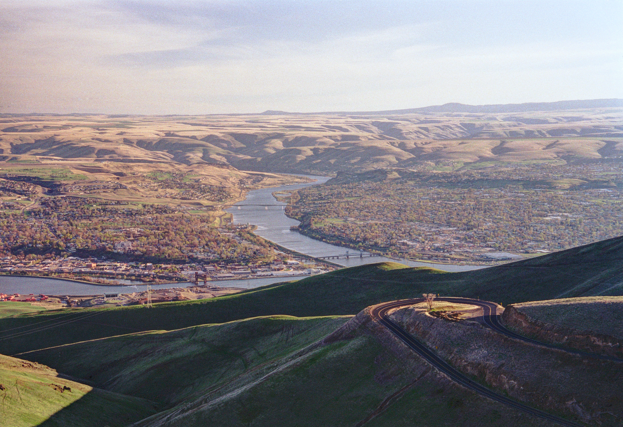
Lower Granite Lake is a reservoir created by Lower Granite Dam. The dam is a concrete gravity run-of-the-river dam in the northwest United States. On the lower Snake River in southeastern Washington, it bridges Whitman and Garfield counties. Opened in 1975, the dam is located south of Colfax and north of Pomeroy. Lower Granite Dam is part of the Columbia River Basin system of dams, built and operated by the United States Army Corps of Engineers; power generated is distributed by the Bonneville Power Administration. Behind the dam, Lower Granite Lake extends east to Lewiston, Idaho and Clarkston, Washington, and allowed the Lewiston–Clarkston metropolitan area to become a port. The first barge to Portland on the navigation route was loaded with wheat and departed Lewiston on August 9, 1975.' Bridges * Southway Bridge - crosses between Lewiston, Idaho and Clarkston, Washington * Interstate Highway Bridge - also crosses between Lewiston and Clarkston, car ... [...More Info...] [...Related Items...] OR: [Wikipedia] [Google] [Baidu] |
Snake River
The Snake River is a major river of the greater Pacific Northwest region in the United States. At long, it is the largest tributary of the Columbia River, in turn, the largest North American river that empties into the Pacific Ocean. The Snake River rises in western Wyoming, then flows through the Snake River Plain of southern Idaho, the rugged Hells Canyon on the Oregon–Idaho border and the rolling Palouse Hills of Washington (state), Washington, emptying into the Columbia River at the Tri-Cities, Washington, Tri-Cities in the Columbia Basin of Eastern Washington. The Snake River drainage basin encompasses parts of six U.S. states (Idaho, Washington, Oregon, Utah, Nevada, and Wyoming) and is known for its varied geologic history. The Snake River Plain was created by a volcanic hotspot (geology), hotspot which now lies underneath the Snake River headwaters in Yellowstone National Park. Gigantic glacial-retreat flooding episodes during the previous Last glacial period, Ice Ag ... [...More Info...] [...Related Items...] OR: [Wikipedia] [Google] [Baidu] |
Garfield County, Washington
Garfield County is a county located in the U.S. state of Washington. As of the 2020 census, the population was 2,286, making it the least populous county in Washington; with about , it is also the least densely populated county in Washington. The county seat and only city is Pomeroy. History The area delineated by the future Washington state boundary began to be colonized at the start of the nineteenth century, both by Americans and British. However, the majority of British exploration and interest in the land was due to the fur trade, whereas American settlers were principally seeking land for agriculture and cattle raising. The Treaty of 1818 provided for the creation of a British and American condominium over the region. During this period, the future Washington Territory was divided into two administrative zones: Clark County and Lewis County (made official in 1845). However, the condominium arrangement was unwieldy, leading to continuous disputes and occasional conflict; ... [...More Info...] [...Related Items...] OR: [Wikipedia] [Google] [Baidu] |
Lewiston And Clarkston
Lewiston may refer to: Places United States * Lewiston, Alabama * Lewiston, California * Lewiston, Georgia *Lewiston, Idaho ** Lewiston, Idaho metropolitan area *Lewiston, Indiana * Lewiston, Maine ** Lewiston, Maine metropolitan area * Lewiston, Michigan *Lewiston, Minnesota * Lewiston, Dakota County, Minnesota, an extinct town *Lewiston, Nebraska * Lewiston (town), New York ** Lewiston (village), New York, a village within the town * Lewiston, North Carolina * Lewiston, Utah * Lewiston, Vermont * Lewiston, Virginia * Lewiston, Wisconsin, a town ** Lewiston (community), Wisconsin, an unincorporated community Elsewhere * Lewiston, Highland, Scotland * Lewiston, South Australia Surname * David Lewiston (1929–2017), British collector of traditional music * Dennis Lewiston (1934–2014), American cinematographer * Harry Lewiston (1900–1965), American showman See also * Lewistown (other) *Leweston (other) Leweston may refer to: *Leweston, Dorset, England, the ... [...More Info...] [...Related Items...] OR: [Wikipedia] [Google] [Baidu] |
Portland, Oregon
Portland (, ) is a port city in the Pacific Northwest and the largest city in the U.S. state of Oregon. Situated at the confluence of the Willamette and Columbia rivers, Portland is the county seat of Multnomah County, the most populous county in Oregon. Portland had a population of 652,503, making it the 26th-most populated city in the United States, the sixth-most populous on the West Coast, and the second-most populous in the Pacific Northwest, after Seattle. Approximately 2.5 million people live in the Portland metropolitan statistical area (MSA), making it the 25th most populous in the United States. About half of Oregon's population resides within the Portland metropolitan area. Named after Portland, Maine, the Oregon settlement began to be populated in the 1840s, near the end of the Oregon Trail. Its water access provided convenient transportation of goods, and the timber industry was a major force in the city's early economy. At the turn of the 20th century, the ... [...More Info...] [...Related Items...] OR: [Wikipedia] [Google] [Baidu] |
Lewiston–Clarkston Metropolitan Area
The Lewiston–Clarkston metropolitan area—colloquially referred to as the Lewiston–Clarkston Valley or Lewis–Clark Valley (often abbreviated as LC Valley), and officially known as the Lewiston, ID–WA Metropolitan Statistical Area—is a metropolitan area comprising Nez Perce County, Idaho and Asotin County, Washington. The metro is anchored by the cities of Lewiston, Idaho and Clarkston, Washington—named after Meriwether Lewis and William Clark, respectively. As of the 2010 census, the MSA had a population of 60,888 (though a July 1, 2011 estimate placed the population at 61,476), making it the 4th smallest metropolitan area in the United States. Geography Counties * Nez Perce County, Idaho *Asotin County, Washington Communities * Anatone, Washington (unincorporated) * Asotin, Washington * Clarkston Heights-Vineland, Washington (unincorporated) *Clarkston, Washington * Culdesac, Idaho *Lapwai, Idaho * Lewiston, Idaho (Principal city) * Peck, Idaho * Spal ... [...More Info...] [...Related Items...] OR: [Wikipedia] [Google] [Baidu] |
Bonneville Power Administration
The Bonneville Power Administration (BPA) is an American federal agency operating in the Pacific Northwest. BPA was created by an act of Congress in 1937 to market electric power from the Bonneville Dam located on the Columbia River and to construct facilities necessary to transmit that power. Congress has since designated Bonneville to be the marketing agent for power from all of the federally owned hydroelectric projects in the Pacific Northwest. Bonneville is one of four regional Federal power marketing agencies within the U.S. Department of Energy (DOE). Operations The power generated on BPA's grid is sold to public utilities, private utilities, and industry on the grid. The excess is sold to other grids in Canada, California and other regions. Because BPA is a public entity, it does not make a profit on power sales or from providing transmission services. BPA also coordinates with the U.S. Army Corps of Engineers and the U.S. Bureau of Reclamation to regulate flow of wa ... [...More Info...] [...Related Items...] OR: [Wikipedia] [Google] [Baidu] |
United States Army Corps Of Engineers
, colors = , anniversaries = 16 June (Organization Day) , battles = , battles_label = Wars , website = , commander1 = LTG Scott A. Spellmon , commander1_label = Chief of Engineers and Commanding General of the U.S. Army Corps of Engineers , commander2 = MGbr>Richard J. Heitkamp, commander2_label = Deputy Chief of Engineers and Deputy Commanding General , commander3 = MGKimberly M. Colloton, commander3_label = Deputy Commanding General for Military and International Operations , commander4 = MGbr>William H. Graham, commander4_label = Deputy Commanding General for Civil and Emergency Operations , commander5 = COLbr>James J. Handura, commander5_label = Chief of Staff for the U.S. Army Corps of Engi ... [...More Info...] [...Related Items...] OR: [Wikipedia] [Google] [Baidu] |
Columbia River
The Columbia River (Upper Chinook: ' or '; Sahaptin: ''Nch’i-Wàna'' or ''Nchi wana''; Sinixt dialect'' '') is the largest river in the Pacific Northwest region of North America. The river rises in the Rocky Mountains of British Columbia, Canada. It flows northwest and then south into the U.S. state of Washington, then turns west to form most of the border between Washington and the state of Oregon before emptying into the Pacific Ocean. The river is long, and its largest tributary is the Snake River. Its drainage basin is roughly the size of France and extends into seven US states and a Canadian province. The fourth-largest river in the United States by volume, the Columbia has the greatest flow of any North American river entering the Pacific. The Columbia has the 36th greatest discharge of any river in the world. The Columbia and its tributaries have been central to the region's culture and economy for thousands of years. They have been used for transportation since a ... [...More Info...] [...Related Items...] OR: [Wikipedia] [Google] [Baidu] |
Pomeroy, Washington
Pomeroy is a city in Garfield County, Washington, United States. The population was 1,425 at the 2010 census. It is the county seat of and only incorporated city in Garfield County. Geography Pomeroy is located at (46.473334, -117.598119). According to the United States Census Bureau, the city has a total area of , all of it land. U.S. Route 12 in Washington serves as the primary highway through town, connecting Pomeroy with the Lewiston–Clarkston metropolitan area (to the east) and the Tri-Cities metro area/ Walla Walla area (to the west). The city is 1,857 ft above sea level in the very hilly region between the Blue Mountains (to the south) and the Palouse region (to the north). The primary highway through town passes over Alpowa Summit (2,785 ft) only a few miles east of town. History The Nez Perce trail existed in the area before history was recorded, and the first written record of caucasians passing through the area were Lewis and Clark in 1805. Captain Benjamin ... [...More Info...] [...Related Items...] OR: [Wikipedia] [Google] [Baidu] |
Colfax, Washington
Colfax is the county seat of Whitman County, Washington, United States. The population was 2,805 at the 2010 census. The population is estimated at 2,911 per the State of Washington Office of Financial Management in 2018 making Colfax the second largest city in Whitman County behind Pullman. It is situated amidst wheat-covered hills in a valley at the confluence of the north and south forks of the Palouse River. U.S. Route 195, which forms the town's main street, intersects with State Route 26 at the north end of town; in the past, Colfax also lay at the junction of three major railway lines. It was named after Schuyler Colfax, the vice president from 1869–73. History Palouse Indians were the first known human inhabitants of the Colfax area. White settlers arrived in the summer of 1870, and soon built a sawmill. A flour mill and other businesses followed, and Colfax soon grew into a prosperous town. Originally, pioneer citizen James Perkins called the settlement "Bellevi ... [...More Info...] [...Related Items...] OR: [Wikipedia] [Google] [Baidu] |
Whitman County, Washington
Whitman County is a county located in the U.S. state of Washington. As of the 2020 census, the population was 47,973. The county seat is Colfax, and its largest city is Pullman. The county was formed from Stevens County in 1871. It is named after Marcus Whitman, a Presbyterian missionary who, with his wife Narcissa, was killed in 1847 by members of the Cayuse tribe. Whitman County comprises the Pullman, Washington Metropolitan Statistical Area. History The area delineated by the future Washington state boundary began to be colonized at the start of the nineteenth century, both by Americans and Canadians. However, the majority of Canadian exploration and interest in the land was due to the fur trade, whereas American settlers were principally seeking land for agriculture and cattle raising. The Treaty of 1818 provided for dual control of this area by US and Canadian government officials. During this period, the future Washington Territory was divided into two administrativ ... [...More Info...] [...Related Items...] OR: [Wikipedia] [Google] [Baidu] |
.jpg)


