|
Loughtee Upper
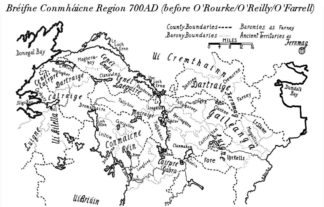
Loughtee Upper (), or Upper Loughtee, is a barony in County Cavan, Republic of Ireland. Baronies were mainly cadastral rather than administrative units. They acquired modest local taxation and spending functions in the 19th century before being superseded by the Local Government (Ireland) Act 1898. Etymology Loughtee Upper takes its name from the Irish ''Lucht Tí'', Early Modern Irish ''lucht tighe Még Mathghamhna'' ( Annals of the Four Masters), "people of the household of Mac Mahon"; the land was allocated to the Mic Bhradaigh vassals of the McMahons as mensal land. Geography Loughtee Upper is located in the middle of County Cavan, east of the River Erne and Lough Oughter. History Loughtee Upper was a centre of power for the Ó Raghallaigh ( O'Reillys) Gaelic Irish tribe in the Middle Ages, based first at Lough Oughter and then moving to Tullymongan near to modern Cavan. The MacGobhains (McGowans) served as leader of the gallowglass. A Mic Bradaigh ( Brady) family ... [...More Info...] [...Related Items...] OR: [Wikipedia] [Google] [Baidu] |
Irish Language
Irish (an Caighdeán Oifigiúil, Standard Irish: ), also known as Gaelic, is a Goidelic languages, Goidelic language of the Insular Celtic branch of the Celtic language family, which is a part of the Indo-European languages, Indo-European language family. Irish is indigenous language, indigenous to the Ireland, island of Ireland and was the population's first language until the 19th century, when English (language), English gradually became Linguistic imperialism, dominant, particularly in the last decades of the century. Irish is still spoken as a first language in a small number of areas of certain counties such as County Cork, Cork, County Donegal, Donegal, County Galway, Galway, and County Kerry, Kerry, as well as smaller areas of counties County Mayo, Mayo, County Meath, Meath, and County Waterford, Waterford. It is also spoken by a larger group of habitual but non-traditional speakers, mostly in urban areas where the majority are second language, second-language speakers. ... [...More Info...] [...Related Items...] OR: [Wikipedia] [Google] [Baidu] |
Lough Oughter
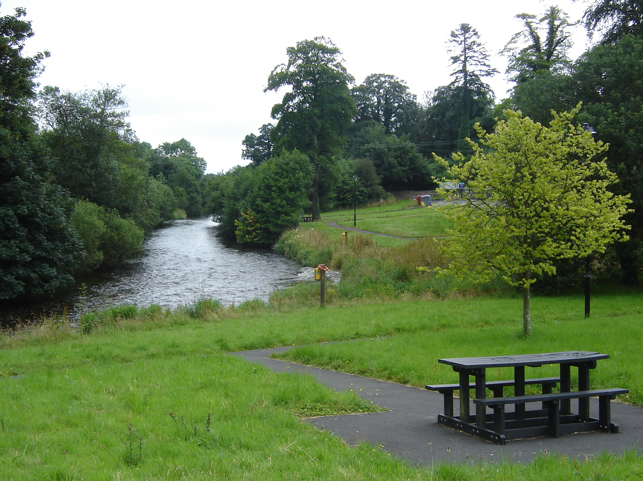
Lough Oughter () is a lake, or complex of lakes, in County Cavan covering more than . The complex of lakes lies on the River Erne, and forms the southern part of the Lough Erne complex. The lakes are bounded roughly by Belturbet in the north, Cavan town to the east, Crossdoney to the south and Killeshandra to the west. Geography and ecology A 1977 report by ''An Foras Forbartha'' (precursor to the Environmental Protection Agency) describes Lough Oughter as the "best inland example of a flooded drumlin landscape" in Ireland, and details the varied biological communities of the area. According to a National Parks and Wildlife Service summary of the site, there is nowhere else in the country with such "mixture of land and water occur over a comparable area", with many species of wetland plants, which are common to Lough Oughter, characterised as "infrequent elsewhere". The number of whooper swans which winter in the area represents about 3% of the total European population whil ... [...More Info...] [...Related Items...] OR: [Wikipedia] [Google] [Baidu] |
Ballyhaise
Ballyhaise (; ) is a village in County Cavan, Ireland. It is situated some north-northeast of Cavan Town. It is approximately a 15-minute drive or 11 km via the N54 to the border with County Fermanagh in Northern Ireland. The River Annalee flows near the village. Location The village of Ballyhaise is located within the parish of Castletara and contains both Roman Catholic and Church of Ireland churches. History Ballyhaise has elements of a planned, Palladian estate village which was built to facilitate a local linen industry in the 1700s. The industry had failed by the 1800s. Today the village is home to a population of 711. The remnants of the Ballyhaise Estate Village lie in the possession of the state who acquired Ballyhaise house in 1905 and has run as an agricultural college ever since. The elaborate gardens of Colonel Newburgh's Ballyhaise house have ceased to exist with time, but Rev. William Henry words' in 1739 remain that Ballyhaise was 'made to last forever ... [...More Info...] [...Related Items...] OR: [Wikipedia] [Google] [Baidu] |
Loughtee Lower
Loughtee Lower (), or Lower Loughtee, is a barony in County Cavan, Republic of Ireland. Baronies were mainly cadastral rather than administrative units. They acquired modest local taxation and spending functions in the 19th century before being superseded by the Local Government (Ireland) Act 1898. Etymology Loughtee Lower takes its name from the Irish ''Lucht Tí'', Early Modern Irish ''lucht tighe Még Mathghamhna'' (Annals of the Four Masters), "people of the household of Mac Mahon"; presumably the land was allocated to the vassals of the McMahon tribe. Geography Loughtee Lower is located in the north of County Cavan, on the River Erne and south of the Woodford River. History The Ó Faircheallaigh (Farrelly) and MacGaghrans (Magaherans) were ruling Gaelic Irish tribes in the area; they were hereditary coarbs and erenachs of Drumlane Abbey, located near here. The barony of Loughtee was created by 1609 in the Plantation of Ulster, and was archaically spelled ''Loughty''. ... [...More Info...] [...Related Items...] OR: [Wikipedia] [Google] [Baidu] |
Undertaker (17th Century)
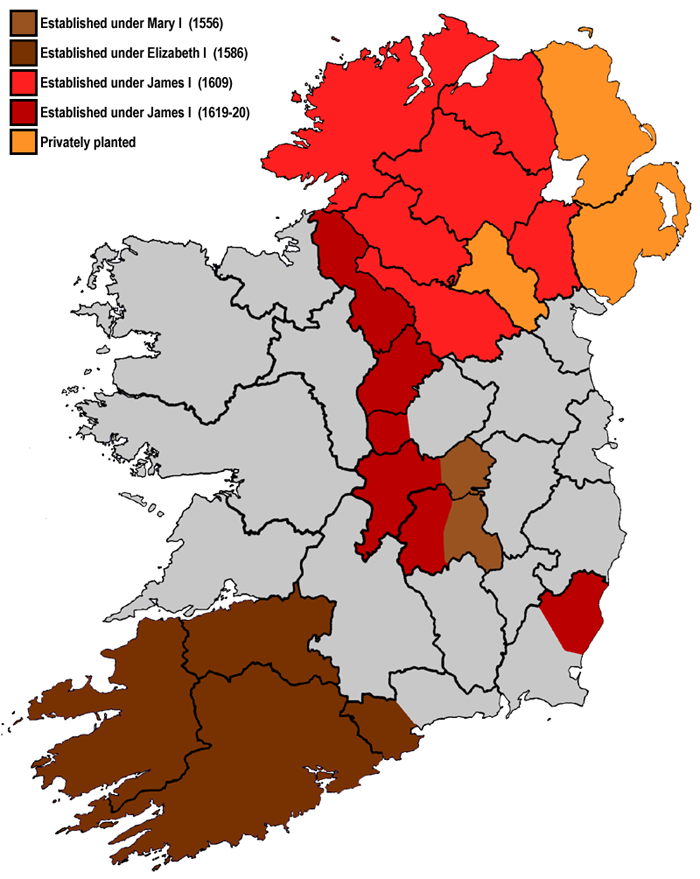
Plantations in 16th- and 17th-century Ireland involved the confiscation of Irish-owned land by the English Crown and the colonisation of this land with settlers from Great Britain. The Crown saw the plantations as a means of controlling, anglicising and 'civilising' Gaelic Ireland. The main plantations took place from the 1550s to the 1620s, the biggest of which was the plantation of Ulster. The plantations led to the founding of many towns, massive demographic, cultural and economic changes, changes in land ownership and the landscape, and also to centuries of ethnic and sectarian conflict. They took place before and during the earliest English colonisation of the Americas, and a group known as the West Country Men were involved in both Irish and American colonization. There had been small-scale immigration from Britain since the 12th century, after the Anglo-Norman invasion. By the 15th century, direct English control had shrunk to an area called the Pale. In the 1540s the ... [...More Info...] [...Related Items...] OR: [Wikipedia] [Google] [Baidu] |
Alluvial
Alluvium (from Latin ''alluvius'', from ''alluere'' 'to wash against') is loose clay, silt, sand, or gravel that has been deposited by running water in a stream bed, on a floodplain, in an alluvial fan or beach, or in similar settings. Alluvium is also sometimes called alluvial deposit. Alluvium is typically geologically young and is not consolidated into solid rock. Sediments deposited underwater, in seas, estuaries, lakes, or ponds, are not described as alluvium. Floodplain alluvium can be highly fertile, and supported some of the earliest human civilizations. Definitions The present consensus is that "alluvium" refers to loose sediments of all types deposited by running water in floodplains or in alluvial fans or related landforms. However, the meaning of the term has varied considerably since it was first defined in the French dictionary of Antoine Furetière, posthumously published in 1690. Drawing upon concepts from Roman law, Furetière defined '' alluvion'' ( ... [...More Info...] [...Related Items...] OR: [Wikipedia] [Google] [Baidu] |
Plantation Of Ulster
The Plantation of Ulster ( gle, Plandáil Uladh; Ulster-Scots: ''Plantin o Ulstèr'') was the organised colonisation ('' plantation'') of Ulstera province of Irelandby people from Great Britain during the reign of King James I. Most of the settlers (or ''planters'') came from southern Scotland and northern England; their culture differed from that of the native Irish. Small privately funded plantations by wealthy landowners began in 1606, while the official plantation began in 1609. Most of the colonised land had been confiscated from the native Gaelic chiefs, several of whom had fled Ireland for mainland Europe in 1607 following the Nine Years' War against English rule. The official plantation comprised an estimated half a million acres (2,000 km2) of arable land in counties Armagh, Cavan, Fermanagh, Tyrone, Donegal, and Londonderry. Land in counties Antrim, Down, and Monaghan was privately colonised with the king's support. Among those involved in planning an ... [...More Info...] [...Related Items...] OR: [Wikipedia] [Google] [Baidu] |
Stradone, County Cavan
Stradone () is a village located in County Cavan, Ireland. It is situated in the civil parish of Laragh (or Larah) six miles from Cavan, near the N3 road between Cavan and Virginia. Stradone is classified as a 'small village' in the Cavan County Council Development Plan 2014-2020. Location Stradone is a small village approximately directly east of Cavan. It is located just off the National Route N3, Dublin to Cavan, where the R165 regional road and L6046 local road converge. It is situated in the Stradone Local Electoral Area. Cavan County Council estimated a population of approximately 60 persons living within the development boundary of the village. History Evidence of ancient settlement in the area includes a number of ringfort sites in the neighbouring townlands of Aghagolrick and Raheelagh. A large estate house in the area, Stradone House, was built between 1828 and 1835 by architect John Benjamin Keane for the landowning Burrows family. While this burned down in 19 ... [...More Info...] [...Related Items...] OR: [Wikipedia] [Google] [Baidu] |
Brady (surname)
Brady is a surname derived from the Irish language, Irish surname Ó Brádaigh or Mac Brádaigh, meaning "spirited; broad". In a listing by the U.S. Census Bureau of the Most Common U.S. Surnames, Brady was ranked at #411 in 2014. The surname was used as a test of nominative determinism in a humorous 2013 article in the ''British Medical Journal''. Surname A *Aidan Brady (1930–1993), Irish Gaelic footballer *Áine Brady (born 1954), Irish politician *Al Brady (1910–1937), American criminal *Alan Brady (1909–1969), Australian rugby union footballer *Alec Brady (1870–1913), Scottish footballer *Alfred Barton Brady (1856–1932), Australian architect *Alice Brady (1892–1939), American silent-film actress *Alice Brady (labour activist) (1898–1914), Irish labour activist *Alison Brady (born 1979), American photographer *Andrea Brady (born 1974), American poet *Angela Brady, Irish architect *Anne-Marie Brady (born 1966), New Zealand political researcher *Anthony Brady ... [...More Info...] [...Related Items...] OR: [Wikipedia] [Google] [Baidu] |
Gallowglass
The Gallowglass (also spelled galloglass, gallowglas or galloglas; from ga, gallóglaigh meaning foreign warriors) were a class of elite mercenary warriors who were principally members of the Norse-Gaelic clans of Ireland between the mid 13th century and late 16th century. Originally applied to Scots, who shared a common background and language with the Irish, but as they were descendants of 10th-century Norse settlers who had intermarried with the local population in western Scotland, the Irish called them ("foreign Gaels"). An early family of gallowglasses was the MacSweeneys, settled by the O'Donnells in north Donegal. These were followed by MacDonnells, MacCabes and several other groups settled by powerful Irish nobles in different areas. The gallowglasses were attractive as heavily armoured, trained infantry to be relied upon as a strong defence for holding a position, unlike most Irish foot soldiers, who were less well armoured than the typical Irish noble who f ... [...More Info...] [...Related Items...] OR: [Wikipedia] [Google] [Baidu] |
McGowan
McGowan is an Irish and Scottish surname. It is an Anglicization of the Irish Mac Gabhann and Scottish surname ''Mac Gobhann''. Belonging to the Uí Echach Cobo, located in modern-day County Down in the east of Ulster, they produced several over-kings of Ulaid. By the late 12th century, the English had expelled the McGowans to Tír Chonaill (now largely modern-day County Donegal) in the west of Ulster. Meaning As noted further in source by John O'Hart, though not an occupational surname, MacGowan evolves as an Anglicization of the original Gaelic language personal description or nickname ''gobha'', meaning "blacksmith". For this reason, the surnames of some septs of the MacGowan are alternately anglicised to Smythe or Smith. Mac, which may appear in anglicised contraction as Mc, sometimes written Mc or, further, abbreviated M', means in English "son", but, when an element used to form a Gaelic language patronymic in its usage of "They have no share in the promise made ... [...More Info...] [...Related Items...] OR: [Wikipedia] [Google] [Baidu] |
Cavan
Cavan ( ; ) is the county town of County Cavan in Ireland. The town lies in Ulster, near the border with County Fermanagh in Northern Ireland. The town is bypassed by the main N3 road that links Dublin (to the south) with Enniskillen, Ballyshannon and Donegal Town (to the north). History Gaelic Cavan 1300–1607 Cavan was founded by the Irish clan chief and Lord of East Breifne, Giolla Íosa Ruadh O’Reilly, between 1300 and his death in 1330. During his lordship, a friary run by the Dominican Order was established close to the O’Reilly stronghold at Tullymongan and was at the centre of the settlement close to a crossing over the river and to the town's marketplace. It is recorded that the (Cavan) Dominicans were expelled in 1393, replaced by an Order of Conventual Franciscan friars. The friary's location is marked by an eighteenth-century tower in the graveyard at Abbey Street which appears to incorporate remains of the original medieval friary tower. The imprin ... [...More Info...] [...Related Items...] OR: [Wikipedia] [Google] [Baidu] |


