|
Losar Baoli
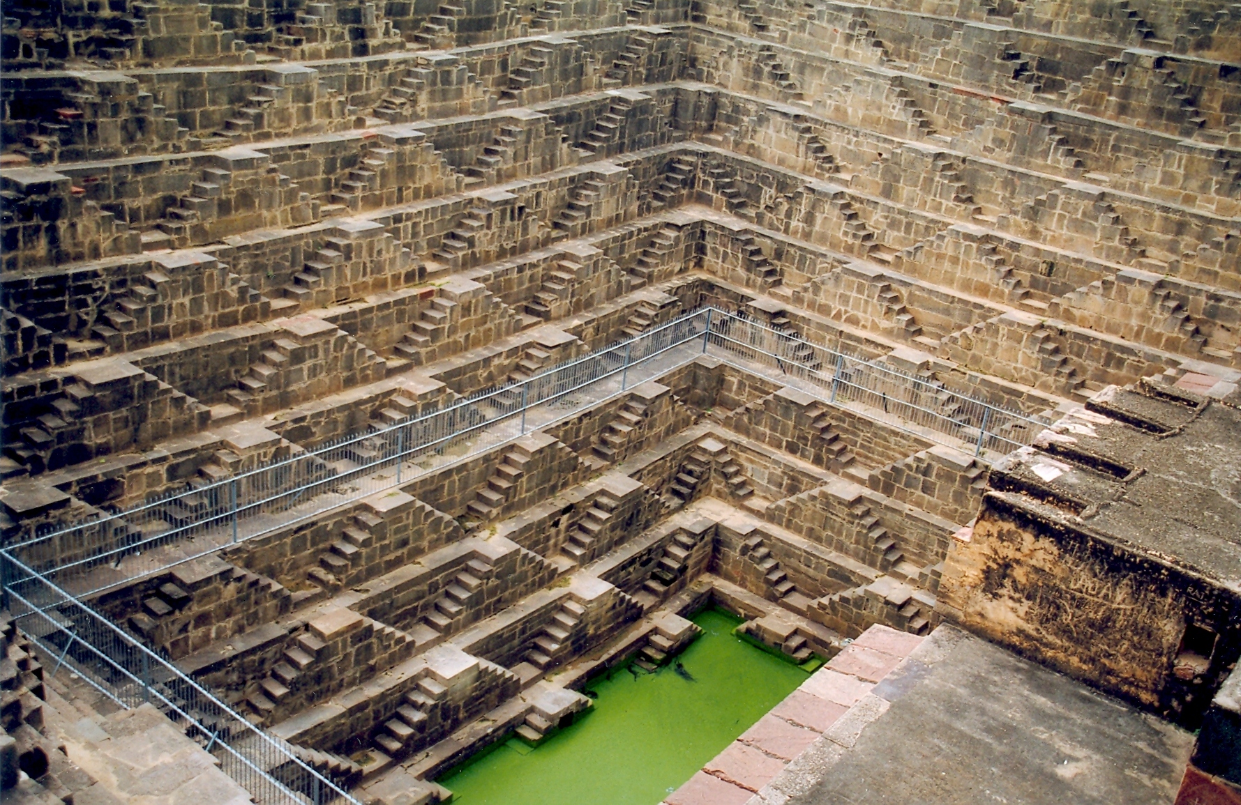
Losar Baoli (the Losar Stepwell) is a stepwell in the Margalla Hills of the Islamabad Capital Territory, Pakistan. Near the town of Shah Allah Ditta in the Potohar Plateau, the area was a passageway for caravans and armies moving along the east–west direction. Constructed using dressed bricks, the well can be accessed from Shah Allah Ditta in Sector D-13, via the Kenthla-Haripur Road, established in 2007 by a federal minister. With a six-foot diameter, the well continues to supply water to local residents for their daily needs. Its surroundings, filled with tree In botany, a tree is a perennial plant with an elongated stem, or trunk, usually supporting branches and leaves. In some usages, the definition of a tree may be narrower, including only woody plants with secondary growth, plants that are ...s and bird songs, provide a restful spot for locals and travelers. Gallery Losar Baoli - Down the steps.JPG, Down the steps of the Losar Baoli Losar Baoli - Full Vie ... [...More Info...] [...Related Items...] OR: [Wikipedia] [Google] [Baidu] |
Stepwell
Stepwells (also known as vavs or baori) are wells or ponds with a long corridor of steps that descend to the water level. Stepwells played a significant role in defining subterranean architecture in western India from 7th to 19th century. Some stepwells are multi-storeyed and can be accessed by a Persian wheel which is pulled by a bull to bring water to the first or second floor. They are most common in western India and are also found in the other more arid regions of the Indian subcontinent, extending into Pakistan. The construction of stepwells is mainly utilitarian, though they may include embellishments of architectural significance, and be temple tanks. Stepwells are examples of the many types of storage and irrigation tanks that were developed in India, mainly to cope with seasonal fluctuations in water availability. A basic difference between stepwells on the one hand, and tanks and wells on the other, is that stepwells make it easier for people to reach the groundwa ... [...More Info...] [...Related Items...] OR: [Wikipedia] [Google] [Baidu] |
Margalla Hills
The Margalla Hills () are a hill range within the Margalla Hills National Park on the northern edge of Islamabad Capital Territory, Pakistan, just south of Haripur District, Khyber Pakhtunkhwa. They are part of the Himalayas, Himalayan foothills. The Margalla range has an area of 12,605 hectares. It is a range with many valleys as well as high mountains. Infrastructure Khayaban-e-Iqbal, arises on the north east side from the 4th Avenue (Nur Pur Shahan), runs between E and F sectors, and ends at Service Road West of F-11 and E-11 (Golra Sharif, Golra) sectors in the south-east. It will be extended up to Grand Trunk Road, Grand Trunk (GT) Road in the near future. Paleontology and archeology According to the research carried out by scientists and archaeologists of the project "Post-Earthquake Explorations of Human Remains in Margalla Hills", the formation of the Margalla Hills dates to the Miocene epoch. The dominant limestone of the Margalla is mixed with sandstone and occas ... [...More Info...] [...Related Items...] OR: [Wikipedia] [Google] [Baidu] |
Islamabad Capital Territory
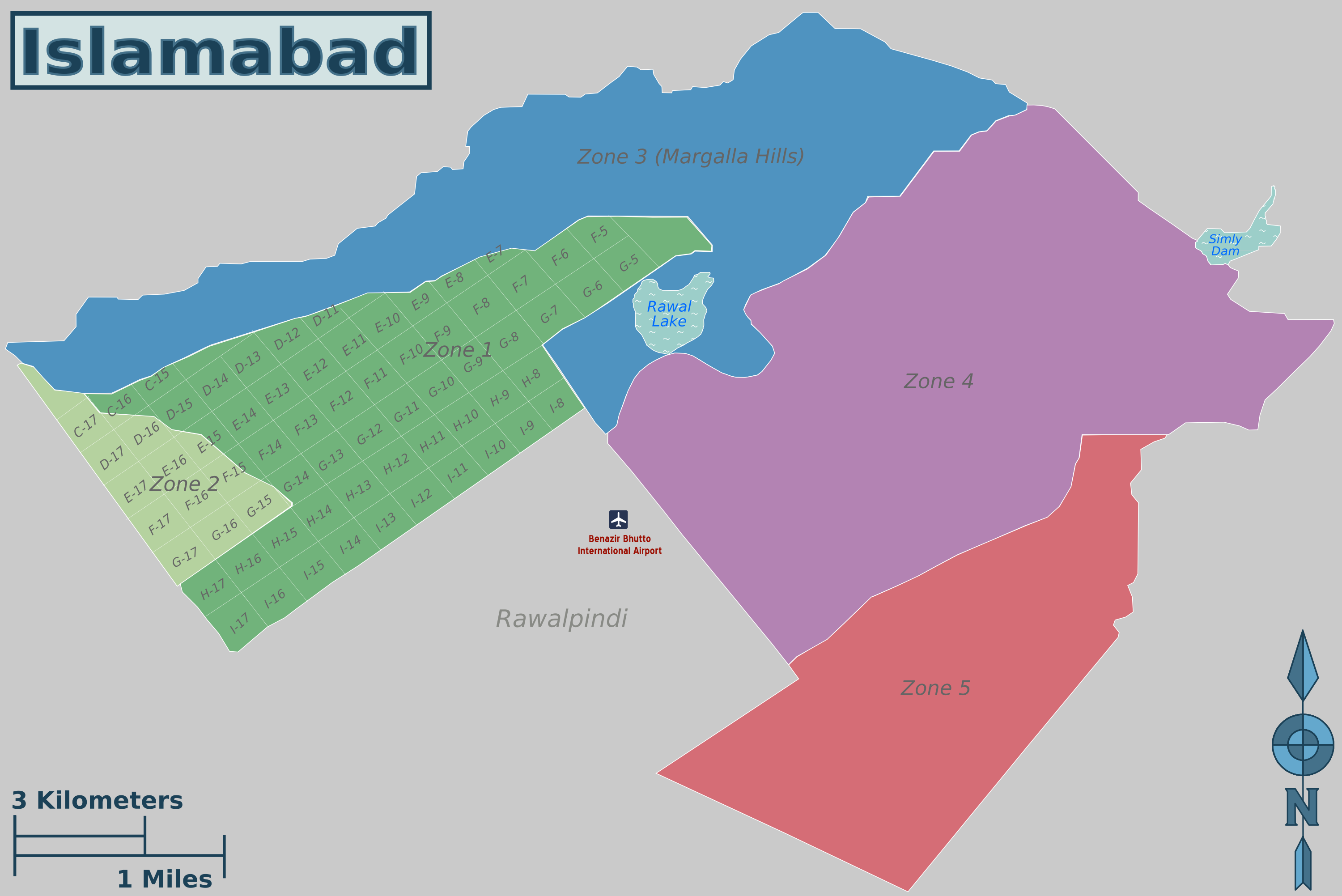
The Islamabad Capital Territory ( ur, , translit=Vafāqī Dār-alhakūmat) is the only federal territory of Pakistan. Located between the provinces of Punjab and Khyber Pakhtunkhwa, it includes the country's capital city of Islamabad. The territory is represented in the NA-52, NA-53, and NA-54 constituencies of the National Assembly and four seats of the Senate. History In 1960, land was transferred from Rawalpindi District of Punjab province to replace Karachi Federal Capital Territory and establish Pakistan's new capital. According to the 1960s master plan, the Capital Territory included Rawalpindi, and was to be composed of the following parts: * Rawalpindi, * Islamabad, * Margalla Hills, * Islamabad rural, However, Rawalpindi was eventually excluded from the Islamabad master plan in the 1980s. Administration Zones Islamabad is subdivided into five zones: *Zone I: Designated for urban development and federal government institutions *Zone II: Designated for urb ... [...More Info...] [...Related Items...] OR: [Wikipedia] [Google] [Baidu] |
Shah Allah Ditta
Shah Allah Ditta ( ur, ) is a centuries-old village and a union council located at the foothills of the Margalla Hills in the Islamabad Capital Territory, Pakistan. It s located adjacent to Sector D-12 of Islamabad. Etymology The village is named after a Mughal period Dervish. History The village is believed to be more than seven hundred years old and lies on the route which was used to travel from Kabul to the Gandharan city of Taxila by Alexander the Great and Sher Shah Suri, while Mughal rulers and other emperors often passed through while traveling from Afghanistan to the Hindustan. Local people used to call that route Gernaili Road (Sher Shah's road), and some of its remnants are still visible today. It is said that Mughal emperor Akbar built a watering hole for travelers in this village. Archeology Relics of the Buddhist era dating back to the 8th century can be found here along with burnt diyas and trees with amulets tied to them. Shah Allah Ditta caves are lo ... [...More Info...] [...Related Items...] OR: [Wikipedia] [Google] [Baidu] |
Potohar Plateau
The Pothohar Plateau ( ur, ) is a plateau in north-eastern Pakistan, located between Indus River and the Jhelum River, forming the northern part of Punjab. Geography Potohar Plateau is bounded on the east by the Jhelum River, on the west by the Indus River, on the north by the Kala Chitta Range and the Margalla Hills, and on the south by the Salt Range. The southern end of the plateau is bounded by the Thal desert. The 5000 square miles of the plateau range from an average height of 1200 to 1900 feet above the sea level. Sakesar in the Salt Range is the highest mountain of the region and Tilla Jogian is the second highest. The Sivapithecus indicus fossil skull of an extinct ape species was discovered in Potohar plateau. Economy The plateau covers about 7 percent of all the cultivated land of Pakistan and most of it is very fertile, but the region does not have any proper irrigation system, with the agriculture being largely dependent on rainfall. The plateau is the location ... [...More Info...] [...Related Items...] OR: [Wikipedia] [Google] [Baidu] |
Federal Minister
A minister is a politician who heads a ministry, making and implementing decisions on policies in conjunction with the other ministers. In some jurisdictions the head of government is also a minister and is designated the ‘prime minister’, ‘premier’, ‘chief minister’, ‘chancellor’ or other title. In Commonwealth realm jurisdictions which use the Westminster system of government, ministers are usually required to be members of one of the houses of Parliament or legislature, and are usually from the political party that controls a majority in the lower house of the legislature. In other jurisdictions—such as Belgium, Mexico, Netherlands, Philippines, Slovenia, and Nigeria—the holder of a cabinet-level post or other government official is not permitted to be a member of the legislature. Depending on the administrative arrangements in each jurisdiction, ministers are usually heads of a government department and members of the government's ministry, cabinet and pe ... [...More Info...] [...Related Items...] OR: [Wikipedia] [Google] [Baidu] |
Water Supply
Water supply is the provision of water by public utilities, commercial organisations, community endeavors or by individuals, usually via a system of pumps and pipes. Public water supply systems are crucial to properly functioning societies. These systems are what supply drinking water to populations around the globe. Aspects of service quality include continuity of supply, water quality and water pressure. The institutional responsibility for water supply is arranged differently in different countries and regions (urban versus rural). It usually includes issues surrounding policy and regulation, service provision and standardization. The cost of supplying water consists, to a very large extent, of fixed costs (capital costs and personnel costs) and only to a small extent of variable costs that depend on the amount of water consumed (mainly energy and chemicals). Almost all service providers in the world charge tariffs to recover part of their costs. Water supply is a separate ... [...More Info...] [...Related Items...] OR: [Wikipedia] [Google] [Baidu] |
Tree
In botany, a tree is a perennial plant with an elongated stem, or trunk, usually supporting branches and leaves. In some usages, the definition of a tree may be narrower, including only woody plants with secondary growth, plants that are usable as lumber or plants above a specified height. In wider definitions, the taller palms, tree ferns, bananas, and bamboos are also trees. Trees are not a taxonomic group but include a variety of plant species that have independently evolved a trunk and branches as a way to tower above other plants to compete for sunlight. The majority of tree species are angiosperms or hardwoods; of the rest, many are gymnosperms or softwoods. Trees tend to be long-lived, some reaching several thousand years old. Trees have been in existence for 370 million years. It is estimated that there are some three trillion mature trees in the world. A tree typically has many secondary branches supported clear of the ground by the trunk. This trunk typically ... [...More Info...] [...Related Items...] OR: [Wikipedia] [Google] [Baidu] |
Bird Song
Bird vocalization includes both bird calls and bird songs. In non-technical use, bird songs are the bird sounds that are melodious to the human ear. In ornithology and birding, songs (relatively complex vocalizations) are distinguished by function from calls (relatively simple vocalizations). Definition The distinction between songs and calls is based upon complexity, length, and context. Songs are longer and more complex and are associated with territory and courtship and mating, while calls tend to serve such functions as alarms or keeping members of a flock in contact. Other authorities such as Howell and Webb (1995) make the distinction based on function, so that short vocalizations, such as those of pigeons, and even non-vocal sounds, such as the drumming of woodpeckers and the "winnowing" of snipes' wings in display flight, are considered songs. Still others require song to have syllabic diversity and temporal regularity akin to the repetitive and transformative patte ... [...More Info...] [...Related Items...] OR: [Wikipedia] [Google] [Baidu] |
Archaeological Sites In Pakistan
Pakistan is home to many archaeological sites dating from Lower Paleolithic period to Mughal empire. The earliest known archaeological findings belong to the Soanian culture from the Soan Valley, near modern-day Islamabad. Soan Valley culture is considered as the best known Palaeolithic culture of Central Asia. Mehrgarh in Balochistan is one of the most important Neolithic sites dating from 7000 BCE to 2000 BCE. The Mehrgarh culture was amongst the first culture in the world to establish agriculture and livestock and live in villages. Mehrgarh civilization lasted for 5000 years till 2000 BCE after which people migrated to other areas, possibly Harappa and Mohenjo-daro. Harappa and Mohenjo-daro are the best known sites from the Indus Valley civilization (c 2500 - 1900 BCE). Stone Age Lower Paleolithic (Pre-Soanian) Pre-Soanian culture in Pakistan corresponds to Oldowan culture dating back to the Mindel glaciation. Some findings in Punjab belong to this period. Lower to Middle Pale ... [...More Info...] [...Related Items...] OR: [Wikipedia] [Google] [Baidu] |


.jpg)


