|
Lopnur
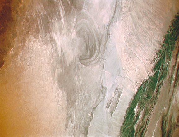
Lop Nur or Lop Nor (from a Mongolian name meaning "Lop Lake", where "Lop" is a toponym of unknown origin) is a former salt lake, now largely dried up, located in the eastern fringe of the Tarim Basin, between the Taklamakan and Kumtag deserts in the southeastern portion of the Xinjiang (Xinjiang Uygur Autonomous Region). Administratively, the lake is in Lop Nur town (), also known as Luozhong () of Ruoqiang County, which in its turn is part of the Bayingolin Mongol Autonomous Prefecture. The lake system into which the Tarim River and Shule River empty is the last remnant of the historical post-glacial Tarim Lake, which once covered more than in the Tarim Basin. Lop Nur is hydrologically endorheic – it is landbound and there is no outlet. The lake measured in 1928, but has dried up due to construction of dams which blocked the flow of water feeding into the lake system, and only small seasonal lakes and marshes may form. The dried-up Lop Nur Basin is covered with a salt cru ... [...More Info...] [...Related Items...] OR: [Wikipedia] [Google] [Baidu] |
Ruoqiang County
Ruoqiang County () as the official romanized name, also transliterated from Uyghur as Qakilik County (; ), is a county in the Xinjiang Uyghur Autonomous Region, China under the administration of the Bayingolin Mongol Autonomous Prefecture. It covers an area of (about twice the size of Zhejiang province and similar to Kyrgyzstan or Senegal), making it the largest county-level division in the country. The county seat is in Ruoqiang Town. This is the location which less-detailed maps will label as "Ruoqiang". It lies at an altitude of . History The ancient settlement of Charklik was located in what is today Ruoqiang County. The Charkhlik Revolt took place here in 1935 when Uyghurs revolted against the Hui-dominated Tunganistan, which was controlled by the 36th Division (National Revolutionary Army). The Uyghurs were defeated. The county was established in 1902 as (''Ruòqiāng'', "recalcitrant Qiang"). In 1959, the less-offensive written form of "若羌" ("like the Qiang") ... [...More Info...] [...Related Items...] OR: [Wikipedia] [Google] [Baidu] |
Ferdinand Von Richthofen
Baron Ferdinand Freiherr von Richthofen (5 May 18336 October 1905), better known in English as was a German traveller, geographer, and scientist. He is noted for coining the terms "Seidenstraße" and "Seidenstraßen" = "Silk Road(s)" or "Silk Route(s)" in 1877."Approaches Old and New to the Silk Roads" Vadime Elisseeff in: ''The Silk Roads: Highways of Culture and Commerce''. Paris (1998) UNESCO, Reprint: Berghahn Books (2000), pp. 1-2. ; ; (pbk)Waugh, Daniel. (2007). "Richthofen's "Silk Roads": Toward the Archaeology of a Concept." ''The Silk Road''. Volume 5, Number 1, Summer 2007, p. 4. He also standardized the practices of chorography and chorology. He was an uncle of the World War I flying ace Manfred von Richthofen, best known as the "Red Baron". Biography Ferdinand von Richthofen was born in Pokój, at that time called Carlsruhe in Prussian Silesia. He was educated in the Roman Catholic Gymnasium in Breslau. He studied Medicine at the University of Breslau and at the ... [...More Info...] [...Related Items...] OR: [Wikipedia] [Google] [Baidu] |
Bayingolin Mongol Autonomous Prefecture
Bayingolin (; often abbreviated to Bayingol; also as Bayinguoleng) is an autonomous prefecture for Mongol people in the southeast of Xinjiang Uyghur Autonomous Region, Western China. It borders Gansu to the east, Qinghai to the southeast and the Tibet Autonomous Region to the south. It is the largest prefecture-level division nationally, with an area of , which is even larger than its neighboring province of Gansu. The prefectural capital is Korla. History In a 2017 announcement from officials in Bayingolin Mongol Autonomous Prefecture, it was proclaimed that "there is a severe threat from international terrorism, and cars have been used as a key means of transport for terrorists as well as constantly serving as weapons. It is therefore necessary to monitor and track all vehicles in the prefecture." Demographics According to the 2000 census, Bayingolin has 1,056,970 inhabitants (population density: 2.28 per km2). As of 2015, 826,063 of the 1,393,812 residents of the coun ... [...More Info...] [...Related Items...] OR: [Wikipedia] [Google] [Baidu] |
Tarim Mummies
The Tarim mummies are a series of mummies discovered in the Tarim Basin in present-day Xinjiang, China, which date from 1800 BC to the first centuries BC, with a new group of individuals recently dated to between c. 2100 and 1700 BC.School of Life Sciences, Jilin University, China, (2021)"The genomic origins of the Bronze Age Tarim Basin mummies" in ENA, European Nucleotide Archive. The mummies, particularly the early ones, are frequently associated with the presence of the Indo-European Tocharian languages in the Tarim Basin,Baumer (2000), p. 28. although the evidence is not totally conclusive and many centuries separate these mummies from the first attestation of the Tocharian languages in writing. Victor H. Mair's team concluded that the mummies are Caucasoid, likely speakers of Indo-European languages such as the Tocharians. A study published in 2021 suggests that the earliest Tarim Basin cultures appear to have had high levels of Ancient North Eurasian ancestry, with smaller ... [...More Info...] [...Related Items...] OR: [Wikipedia] [Google] [Baidu] |
Mongolian Language
Mongolian is the official language of Mongolia and both the most widely spoken and best-known member of the Mongolic language family. The number of speakers across all its dialects may be 5.2 million, including the vast majority of the residents of Mongolia and many of the ethnic Mongol residents of the Inner Mongolia Autonomous Region of the People's Republic of China.Estimate from Svantesson ''et al.'' (2005): 141. In Mongolia, Khalkha Mongolian is predominant, and is currently written in both Cyrillic and traditional Mongolian script. In Inner Mongolia, the language is dialectally more diverse and is written in the traditional Mongolian script. However, Mongols in both countries often use the Latin script for convenience on the Internet. In the discussion of grammar to follow, the variety of Mongolian treated is the standard written Khalkha formalized in the writing conventions and in grammar as taught in schools, but much of what is to be said is also valid for vernacular ... [...More Info...] [...Related Items...] OR: [Wikipedia] [Google] [Baidu] |
Archaeology
Archaeology or archeology is the scientific study of human activity through the recovery and analysis of material culture. The archaeological record consists of artifacts, architecture, biofacts or ecofacts, sites, and cultural landscapes. Archaeology can be considered both a social science and a branch of the humanities. It is usually considered an independent academic discipline, but may also be classified as part of anthropology (in North America – the four-field approach), history or geography. Archaeologists study human prehistory and history, from the development of the first stone tools at Lomekwi in East Africa 3.3 million years ago up until recent decades. Archaeology is distinct from palaeontology, which is the study of fossil remains. Archaeology is particularly important for learning about prehistoric societies, for which, by definition, there are no written records. Prehistory includes over 99% of the human past, from the Paleolithic until the adven ... [...More Info...] [...Related Items...] OR: [Wikipedia] [Google] [Baidu] |
Aurel Stein
Sir Marc Aurel Stein, ( hu, Stein Márk Aurél; 26 November 1862 – 26 October 1943) was a Hungarian-born British archaeologist, primarily known for his explorations and archaeological discoveries in Central Asia. He was also a professor at Indian universities. Stein was also an ethnographer, geographer, linguist and surveyor. His collection of books and manuscripts bought from Dunhuang caves is important for the study of the history of Central Asia and the art and literature of Buddhism. He wrote several volumes on his expeditions and discoveries which include ''Ancient Khotan'', ''Serindia'' and ''Innermost Asia''. Early life Stein was born to Náthán Stein and Anna Hirschler, a Jewish couple residing in Budapest in the Kingdom of Hungary. His parents and his sister retained their Jewish faith but Stein and his brother, Ernst Eduard, were baptised as Lutherans. At home the family spoke German and Hungarian, Stein attended Catholic and Lutheran gymnasiums in Budapest, w ... [...More Info...] [...Related Items...] OR: [Wikipedia] [Google] [Baidu] |
Sven Hedin
Sven Anders Hedin, KNO1kl RVO,Wennerholm, Eric (1978) ''Sven Hedin – En biografi'', Bonniers, Stockholm (19 February 1865 – 26 November 1952) was a Swedish geographer, topographer, explorer, photographer, travel writer and illustrator of his own works. During four expeditions to Central Asia, he made the Transhimalaya known in the West and located sources of the Brahmaputra, Indus and Sutlej Rivers. He also mapped lake Lop Nur, and the remains of cities, grave sites and the Great Wall of China in the deserts of the Tarim Basin. In his book '' Från pol till pol'' (''From Pole to Pole''), Hedin describes a journey through Asia and Europe between the late 1880s and the early 1900s. While traveling, Hedin visited Turkey, the Caucasus, Tehran, Iraq, lands of the Kyrgyz people and the Russian Far East, India, China and Japan. The posthumous publication of his ''Central Asia Atlas'' marked the conclusion of his life's work. Overview At 15 years of age, Hedin witnessed the tri ... [...More Info...] [...Related Items...] OR: [Wikipedia] [Google] [Baidu] |
Nikolai Przhevalsky
Nikolay Mikhaylovich Przhevalsky (or Prjevalsky;; pl, Nikołaj Przewalski, . – ) was a Russian geographer of Polish descent (he was born in a Polish noble family), and a renowned explorer of Central and East Asia. Although he never reached his ultimate goal, the holy city of Lhasa in Tibet, he traveled through regions then unknown to the West, such as northern Tibet (modern Tibet Autonomous Region), Amdo (now Qinghai) and Dzungaria (now northern Xinjiang). He contributed substantially to European knowledge of Central Asian geography. He also described several species previously unknown to European science: Przewalski's horse, Przewalski's gazelle, and the wild Bactrian camel, all of which are now endangered. He was a mentor of his follower Pyotr Kozlov. Biography Przhevalsky was born in Kimborovo, in the Smolensky Uyezd of the Smolensk Governorate of the Russian Empire in the Polish noble family. He studied there and at the military academy in St. Petersburg. In ... [...More Info...] [...Related Items...] OR: [Wikipedia] [Google] [Baidu] |
Lop Desert
The Lop Desert, or the Lop Depression, is a desert extending from Korla eastwards along the foot of the Kuruk-tagh (meaning Dry Mountain) to the former terminal Tarim Basin in the Xinjiang Uyghur Autonomous Region of China. It is an almost perfectly flat expanse with no topographic relief. Lake Bosten in the northwest lies at an altitude of , while the Lop Nur in the southeast is only 250 m lower. Geography The Lop Desert is on the whole flat, but with three slightly more depressed areas which might form lakes if filled with water - the Lop Nor dried basin, Kara-Koshun dried basin and the Taitema Lake basin. These formed, at one time or another, the terminal lakes of the Tarim-Konque- Qarqan river system. The Tarim River changes its course through time, and therefore the location of the terminal lake also changes, causing some confusion amongst the early explorers as to the exact location of Lop Nor, and the lake was thus referred to as the "Wandering Lake." In the past Lop Nur w ... [...More Info...] [...Related Items...] OR: [Wikipedia] [Google] [Baidu] |
Marco Polo
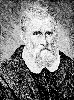
Marco Polo (, , ; 8 January 1324) was a Venetian merchant, explorer and writer who travelled through Asia along the Silk Road between 1271 and 1295. His travels are recorded in ''The Travels of Marco Polo'' (also known as ''Book of the Marvels of the World '' and ''Il Milione'', ), a book that described to Europeans the then mysterious culture and inner workings of the Eastern world, including the wealth and great size of the Mongol Empire and China in the Yuan Dynasty, giving their first comprehensive look into China, Persia, India, Japan and other Asian cities and countries. Born in Venice, Marco learned the mercantile trade from his father and his uncle, Niccolò and Maffeo, who travelled through Asia and met Kublai Khan. In 1269, they returned to Venice to meet Marco for the first time. The three of them embarked on an epic journey to Asia, exploring many places along the Silk Road until they reached Cathay (China). They were received by the royal court of Kublai Khan, ... [...More Info...] [...Related Items...] OR: [Wikipedia] [Google] [Baidu] |
Indus Valley
The Indus ( ) is a transboundary river of Asia and a trans-Himalayan river of South and Central Asia. The river rises in mountain springs northeast of Mount Kailash in Western Tibet, flows northwest through the disputed region of Kashmir, Quote: "Kashmir, region of the northwestern Indian subcontinent. It is bounded by the Uygur Autonomous Region of Xinjiang to the northeast and the Tibet Autonomous Region to the east (both parts of China), by the Indian states of Himachal Pradesh and Punjab to the south, by Pakistan to the west, and by Afghanistan to the northwest. The northern and western portions are administered by Pakistan and comprise three areas: Azad Kashmir, Gilgit, and Baltistan, ... The southern and southeastern portions constitute the Indian state of Jammu and Kashmir. The Indian- and Pakistani-administered portions are divided by a "line of control" agreed to in 1972, although neither country recognizes it as an international boundary. In addition, China became ... [...More Info...] [...Related Items...] OR: [Wikipedia] [Google] [Baidu] |


.jpg)


