|
Londonthorpe And Harrowby Without
Londonthorpe and Harrowby Without is a civil parish in the South Kesteven district of Lincolnshire, England. According to the 2001 Census it had a population of 4,344, in 1743 households, increasing to a population of 5,133 at the 2011 census. It includes the village of Londonthorpe and the hamlet of Harrowby, Lincolnshire. Originally a township of Grantham, Harrowby was created a civil parish in 1866, and in 1894 it was split into two separate civil parishes, Harrowby Within, and Harrowby Without. In 1909 Harrowby Within was abolished and merged with the town of Grantham. In October 1930 Harrowby Without was reduced in size to enlarge the town, and in 1931 the parish was abolished and merged with Londonthorpe and Spittlegate Without to create Londonthorpe and Harrowby Without civil parish. Geography The parish is bounded on the east by the High Dyke (Ermine Street), the modern B6403 road. The Southern boundary follows traditional field lines from near ''Griffs Plantatio ... [...More Info...] [...Related Items...] OR: [Wikipedia] [Google] [Baidu] |
Civil Parish
In England, a civil parish is a type of Parish (administrative division), administrative parish used for Local government in England, local government. It is a territorial designation which is the lowest tier of local government below districts of England, districts and metropolitan and non-metropolitan counties of England, counties, or their combined form, the Unitary authorities of England, unitary authority. Civil parishes can trace their origin to the ancient system of Parish (Church of England), ecclesiastical parishes, which historically played a role in both secular and religious administration. Civil and religious parishes were formally differentiated in the 19th century and are now entirely separate. Civil parishes in their modern form came into being through the Local Government Act 1894, which established elected Parish councils in England, parish councils to take on the secular functions of the vestry, parish vestry. A civil parish can range in size from a sparsely ... [...More Info...] [...Related Items...] OR: [Wikipedia] [Google] [Baidu] |
Ermine Street
Ermine Street is a major Roman road in England that ran from London (''Londinium'') to Lincoln ('' Lindum Colonia'') and York (''Eboracum''). The Old English name was ''Earninga Strǣt'' (1012), named after a tribe called the ''Earningas'', who inhabited a district later known as ''Armingford Hundred'', around Arrington, Cambridgeshire, and Royston, Hertfordshire. "Armingford", and "Arrington" share the same Old English origin. The original Celtic and Roman names for the route remain unknown. It is also known as the Old North Road from London to where it joins the A1 Great North Road near Godmanchester. Course Ermine Street begins at Bishopsgate, where one of the seven gates in the wall surrounding Roman London was located. From here it runs north up Norton Folgate, Shoreditch High Street and Kingsland Road through Stoke Newington (forming Stoke Newington Road and Stoke Newington High Street), Tottenham, Edmonton and eastern Enfield (Ponders End, Enfield Highw ... [...More Info...] [...Related Items...] OR: [Wikipedia] [Google] [Baidu] |
Lincolnshire Limestone
The Lincolnshire Limestone Formation is a geological formation in England, part of the Inferior Oolite Group of the (Bajocian) Middle Jurassic strata of eastern England. It was formed around 165 million years ago, in a shallow, warm sea on the margin of the London Platform and has estuarine beds above and below it. The maximum known thickness is 40.2 metres, at around TF9730, while four kilometres further west it is 18.3 metres thick at its outcrop in the upper Witham valley. It fades out in the south, around Kettering in Northamptonshire. There are two sub-divisions, the Upper and Lower Lincolnshire Limestone Members respectively. The dividing marker is the 'Crossi' bed which is distinguished by the fossils of ''Acanthothris crossi'' it contains. The Crossi bed forms the top of the Lower Lincolnshire limestone. The bottom of the Lower Lincolnshire limestone has some of the characteristics of the underlying Lower Estuarine Series, in that it tends to contain more than usual amoun ... [...More Info...] [...Related Items...] OR: [Wikipedia] [Google] [Baidu] |
A52 Road
A5 and variants may refer to: Science and mathematics * A5 regulatory sequence in biochemistry * A5, the abbreviation for the androgen Androstenediol * Annexin A5, a human cellular protein * ATC code A05 ''Bile and liver therapy'', a subgroup of the Anatomical Therapeutic Chemical Classification System * British NVC community A5 (Ceratophyllum demersum community), a British Isles plants community * Subfamily A5, a Rhodopsin-like receptors subfamily * Noradrenergic cell group A5, a noradrenergic cell group located in the Pons * A5 pod, a name given to a group of orcas (Orcinus orca) found off the coast of British Columbia, Canada * A5, the strain at fracture of a material as measured with a load test on a cylindrical body of length 5 times its diameter * ''A''5, the alternating group on five elements Technology * Apple A5, the Apple mobile microprocessor * ARM Cortex-A5, ARM applications processor Sport and recreation * A5 (classification), an amputee sport classification * A ... [...More Info...] [...Related Items...] OR: [Wikipedia] [Google] [Baidu] |
Territorial Army (United Kingdom)
The Army Reserve is the active-duty volunteer reserve force of the British Army. It is separate from the Regular Reserve whose members are ex-Regular personnel who retain a statutory liability for service. The Army Reserve was known as the Territorial Force from 1908 to 1921, the Territorial Army (TA) from 1921 to 1967, the Territorial and Army Volunteer Reserve (TAVR) from 1967 to 1979, and again the Territorial Army (TA) from 1979 to 2014. The Army Reserve was created as the Territorial Force in 1908 by the Secretary of State for War, Richard Haldane, when the Territorial and Reserve Forces Act 1907 combined the previously civilian-administered Volunteer Force, with the mounted Yeomanry (at the same time the Militia was renamed the Special Reserve). Haldane planned a volunteer "Territorial Force", to provide a second line for the six divisions of the Expeditionary Force which he was establishing as the centerpiece of the Regular Army. The Territorial Force was to be c ... [...More Info...] [...Related Items...] OR: [Wikipedia] [Google] [Baidu] |
Prince William Of Gloucester Barracks
Prince William of Gloucester Barracks is a military installation near Grantham in Lincolnshire. History The barracks were established, on the site of the former RAF Spitalgate airbase, in October 1976, as the new Central Volunteer Headquarters for the Royal Corps of Transport. The barracks were formally named after Prince William of Gloucester at a ceremony held in March 1977 led by Princess Alice, Duchess of Gloucester. The Central Volunteer Headquarters were renamed the Royal Corps of Transport Territorial Army Depot and Training Centre in 1979. The facility provided centralised training for all volunteer members of the Royal Corps of Transport. In 1982 the first holder of the new post of Commander Royal Corps of Transport Territorial Army ('Commander RCT TA') moved into the barracks. In the 1980s the barracks also served as home to 54th Infantry Brigade. The barracks remain the home of Headquarters Royal Logistic Corps Army Reserve and of the Army Training Regiment (Grantham) ... [...More Info...] [...Related Items...] OR: [Wikipedia] [Google] [Baidu] |
Belton House
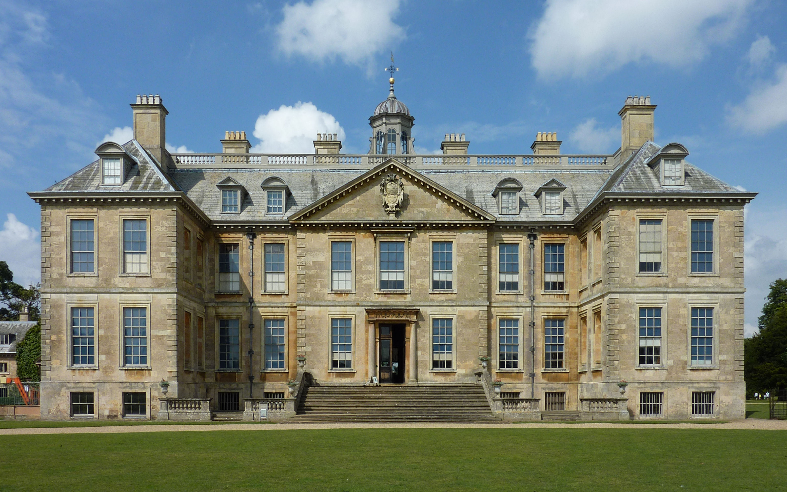
Belton House is a Grade I listed country house in the parish of Belton near Grantham in Lincolnshire, England, built between 1685 and 1688 by Sir John Brownlow, 3rd Baronet. It is surrounded by formal gardens and a series of avenues leading to follies within a larger wooded park. Belton has been described as a compilation of all that is finest of Carolean architecture, the only truly vernacular style of architecture that England had produced since the Tudor period.Nicolson, 148. It is considered to be a complete example of a typical English country house. For about three centuries until 1984, Belton House was the seat successively of the Brownlow family, which had first acquired land in the area in the late 16th century, and of its heirs the Cust family (in 1815 created Earl Brownlow). Despite his great wealth Sir John Brownlow, 3rd Baronet, chose to build a comparatively modest house rather than one of the grand Baroque palaces being built by others at the time. The conte ... [...More Info...] [...Related Items...] OR: [Wikipedia] [Google] [Baidu] |
Little Ponton And Stroxton
Little Ponton and Stroxton is a civil parish in the South Kesteven district of Lincolnshire, England. According to the 2001 Census it had a population of 135 across 62 homes, increasing to 235 at the 2011 census. The civil parish contains the villages of Little Ponton and Stroxton, the Nature reserve of ''Woodnock Valley'', The site of a Roman settlement, and part of the Roman road of Ermine Street (known locally as the High Dyke). Civil parish The parish was created in 1931 by combining the former civil parishes of ''Little Ponton'' and ''Stroxton''. Local democracy is represented by a parish council, which has been criticised for certain technical failings. History The site of a Roman settlement at Saltersford on the Witham has been identified as the Roman town of '' Causennae'' or '' Causennis'' mentioned in the Antonine itinerary. Saltersford itself was part of an ancient trading route from Droitwich to the Wash. Part of the Roman road of Ermine Street (known locally as ... [...More Info...] [...Related Items...] OR: [Wikipedia] [Google] [Baidu] |
River Witham
The River Witham is a river almost entirely in the county of Lincolnshire in the east of England. It rises south of Grantham close to South Witham at , passes through the centre of Grantham (where it may be closely followed using the Riverside Walk through Wyndham Park and Queen Elizabeth Park), passes Lincoln at and at Boston, , flows into The Haven, a tidal arm of The Wash, near RSPB Frampton Marsh. The name "Witham" seems to be extremely old and of unknown origin.; see Old European hydronymy Archaeological and documentary evidence shows the importance of the Witham as a navigable river from the Iron Age onwards. From Roman times it was navigable to Lincoln, from where the Fossdyke was constructed to link it to the River Trent. The mouth of the river moved in 1014 following severe flooding, and Boston became important as a port. From 1142 onwards, sluices were constructed to prevent flooding by the sea, and this culminated in the Great Sluice, which was constructed in 1 ... [...More Info...] [...Related Items...] OR: [Wikipedia] [Google] [Baidu] |
High Dyke, Lincolnshire
High Dyke is a minor road following a length of the Roman Road Ermine Street in the English county of Lincolnshire, between Woolsthorpe-by-Colsterworth and Ancaster, and onwards nearly to Bracebridge Heath. It is also the name of a small settlement on that road, south-east from Great Ponton, near to the mouth of Stoke Tunnel on the East Coast Main Line. High Dyke is also a name for the general area between Easton and Great Ponton. On the Ordnance Survey 1:25000 sheets it is spelled ''High Dike''. Junctions Recent rebuilding of the A1 road junction at Woolsthorpe-by-Colsterworth in 2008 has included construction of a grade-separated road crossing in place of the disused railway bridge that was part of the High Dyke branch, a mineral railway used to export iron ore between 1916 and 1973. There is a roundabout adjacent to Prince William of Gloucester Barracks east of Grantham, but all other junctions are conventional grade-level crossroads or T junctions. Route The mo ... [...More Info...] [...Related Items...] OR: [Wikipedia] [Google] [Baidu] |
South Kesteven
South Kesteven is a local government district in Lincolnshire, England, forming part of the traditional Kesteven division of the county. It covers Bourne, Grantham, Market Deeping and Stamford. The 2011 census reports 133,788 people at 1.4 per hectare in 57,344 households. The district borders the counties of Cambridgeshire, Leicestershire, Northamptonshire, Nottinghamshire and Rutland. It is also bounded by the Lincolnshire districts of North Kesteven and South Holland. History The district was formed on 1 April 1974, under the Local Government Act 1972, from the municipal boroughs of Grantham and Stamford, along with Bourne Urban District, South Kesteven Rural District, and West Kesteven Rural District. Previously the district was run by Kesteven County Council, based in Sleaford. Geography South Kesteven borders North Kesteven to the north, as far east as Horbling, where the A52 crosses the South Forty-Foot Drain. From there south it borders South Holland along the South ... [...More Info...] [...Related Items...] OR: [Wikipedia] [Google] [Baidu] |
Army Housing - Geograph
An army (from Old French ''armee'', itself derived from the Latin verb ''armāre'', meaning "to arm", and related to the Latin noun ''arma'', meaning "arms" or "weapons"), ground force or land force is a fighting force that fights primarily on land. In the broadest sense, it is the land-based military branch, service branch or armed service of a nation or country. It may also include aviation assets by possessing an army aviation component. Within a national military force, the word army may also mean a field army. In some countries, such as France and China, the term "army", especially in its plural form "armies", has the broader meaning of armed forces as a whole, while retaining the colloquial sense of land forces. To differentiate the colloquial army from the formal concept of military force, the term is qualified, for example in France the land force is called ''Armée de terre'', meaning Land Army, and the air and space force is called ''Armée de l'Air et de l’Espace ... [...More Info...] [...Related Items...] OR: [Wikipedia] [Google] [Baidu] |


