|
Loch Bracadale
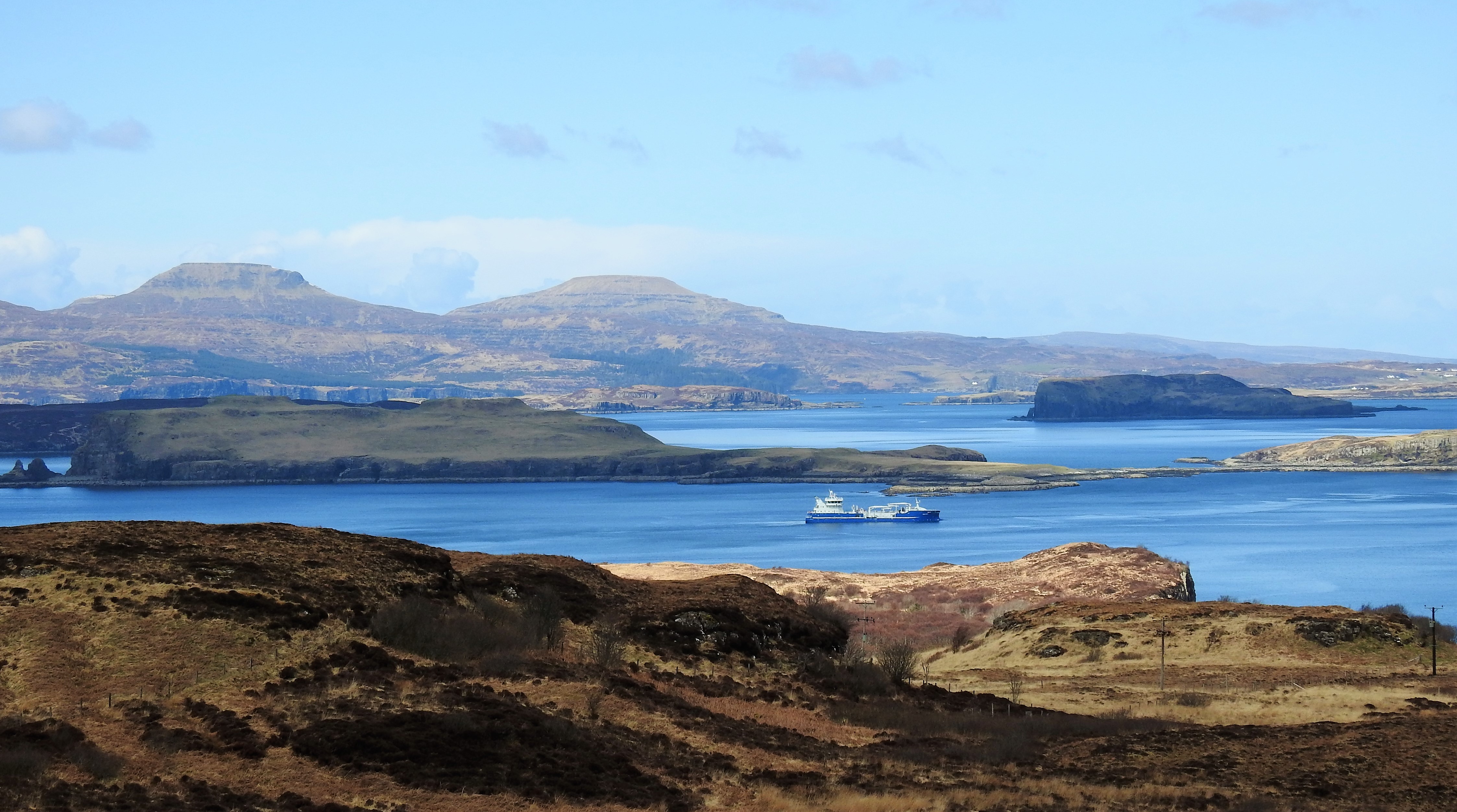
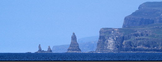
Loch Bracadale (Scottish Gaelic: ''Loch Bhràcadail'') is a sea loch on the west coast of Skye in Scotland. It separates the Minginish Peninsula in the south from the Duirinish Peninsula in the north. Loch Bracadale and its associated inner lochs - Loch Harport, Loch Vatten, Loch Caroy, Loch Bharcasaig, Loch na Faolinn and Loch Beag - form one of the largest areas of semi-enclosed inshore waters around the Skye coast. The shallow waters are used for salmon and mussel farms, crab and lobster creels as well as scallop diving. The loch contains four islands; Harlosh Island, Tarner Island, Wiay and the tidal island of Oronsay off Ullinish point. The mouth of Loch Bracadale (where it opens to the Atlantic) is some wide, from Idrigill Point on the Duirinish Peninsula to Rubha nan Clach on the Minginish Peninsula. west of Idrigill Point are the three sea stacks known as Macleod's Maidens. On the south-western shore of the loch, from Rubha nan Clach are impressive sea cliffs ... [...More Info...] [...Related Items...] OR: [Wikipedia] [Google] [Baidu] |
Oronsay, Loch Bracadale
Oronsay ( gd, Orasaigh) is an uninhabited tidal island in Loch Bracadale on the west coast of Skye, Scotland. It is c.1,000 metres (0.7miles) long by 220m wide running approximately north-east to south west. At low tide (approx. below 4 metres) the island is connected to Ullinish Point on Skye via a narrow rocky causeway, some 200m long. The name Oronsay is believed to derive from the Old Norse for 'tidal island'. The eastern part of the island, which faces Skye, is low-lying grass land, while the western part rises until it reaches several cliffs, up to in height. Views from the westward side are to the Atlantic, Idrigill Point, Macleod's Maidens, with the much larger island of Wiay c.0.8 miles north-west, behind which the flat tops of Healabhal Bheag and Healabhal Mhòr (Macleod's Tables) dominate from the Duirinish Peninsula. Behind Wiay some 2.7miles north-west is Harlosh Island Harlosh Island is one of four islands to be found in Isle of Skye, Skye's Loch Brac ... [...More Info...] [...Related Items...] OR: [Wikipedia] [Google] [Baidu] |
Tarner Island
Tarner Island is a triangular shaped island in Loch Bracadale just off the coast off the Harlosh peninsula of Skye in Scotland. It is about in extent and is 0.65 miles at its longest by 0.33 miles at its widest The coastline is largely cliff-lined and rocky however slopes down to the northernmost part of the island at which point it is possible to land by small boat or kayak. Tarner Island is dotted with small sea caves around the perimeter, many large enough to kayak into, and there is a natural arch to the north. The west of the island is dominated by cliffs and a large leaning boulder, known as 'Fingal's Limpet Hammer'. ("''A huge block of trap, which has slipped from the face of a cliff in one of the islands of Loch Bracadale in Skye, is called ' Ord-bàirnich Fhinn,' Fingal's limpet-hammer.''" Tarner Island is 0.5 miles from mainland Skye at its nearest point and there are several skerries including Sgeir Mhòr and Sgeir Bheag that lie just offshore to the north east be ... [...More Info...] [...Related Items...] OR: [Wikipedia] [Google] [Baidu] |
Ullinish
Ullinish (Gaelic: Uilfhinis) is a crofting township on Loch Bracadale, on the southwest coast of Skye, Scotland. The only promontory fort on Skye is located at Ullinish. It is situated to the west of Struan and just south of the hamlet of Ebost. Historically, Ullinish is associated with the MacLeod family. Of literary note, Samuel Johnson's views and denunciation of James Macpherson's ''Ossian'' were confirmed while Johnson was in Ullinish. Etymology The name Ullinish is from Old Norse ''úlfa-nes'', meaning "promontory of the wolves". In Gaelic, it is sometimes spelt as ''Uilinis'' or ''Uilbhinis''. Geography Located on the Inner Hebrides, Ullinish lies on a small peninsula, with a boggy moorland ending at Ullinish Point. Loch Caroy is situated between Ullinish Point and Harlosh Island. The small tidal island of Oronsay is joined to Ullinish Point at low tide, and separated by a breakwater. The town is overlooked by the low, basalt cliffs of the Cuillin Hills, and MacL ... [...More Info...] [...Related Items...] OR: [Wikipedia] [Google] [Baidu] |
Bracadale
Bracadale ( gd, Bracadal) is a settlement and parish on the Isle of Skye in Scotland. It lies on the west coast of the island, west-south-west of Portree, on Loch Beag, an inlet off Loch Harport. Nearby settlements include Struan to the west and Coillore on the opposite shore of Loch Beag. The name could derive from the Old Norse for "juniper dale" or "bracken dale"; or from the Scottish Gaelic ''breac'' and ''dail'', meaning "spotted valley", or "valley of the trout/salmon". See also * Loch Bracadale * Alastair Campbell, Lord Bracadale - Scottish judge * Roderick McLeod (minister) Roderick McLeod (1794–1868) was a Scottish minister of the Free Church of Scotland (1843–1900), Free Church of Scotland who served as Moderator of the General Assembly 1863/64. Life He was born at Glen Haltin on Skye in 1794, the son of ... minister suspended in the Bracadale Case. Not to be confused with his namesake who wrote the Statistical Account for Bracadale References P ... [...More Info...] [...Related Items...] OR: [Wikipedia] [Google] [Baidu] |
Fiskavaig
Fiskavaig or Fiscavaig ( gd, Fiosgabhaig) is a picturesque crofting settlement on the north-west shore of the Minginish peninsula, Isle of Skye in the Highland Council area. The township extends westward around the coast some 2.5 miles from Ardtreck in the east, originally however Fiskavaig was a small hamlet centred on the west side of Fiskavaig Bay, (where Fiskavaig Burn enters), at which the remains of several houses can still be seen. These appear to have been inhabited up until the end of the 19th century, and the remains of a small stone pier is still evident. An 1877 Ordnance Survey Map shows several houses in this location and although unclear how many were inhabited at the time the OS Name Book notes that the name Fiskavaig: ".''..is applied to a hamlet of thatched houses occupied by work men in service of the Talisker farmer, the houses are one storey & have a wretched appearance On the property of McLeod of McLeod. The name is Anglicised Fiskr, a fish: vagr, a bay = ... [...More Info...] [...Related Items...] OR: [Wikipedia] [Google] [Baidu] |
Wiay, Skye
Wiay, pronounced "waya" (Gaelic: Fuidheigh) is an uninhabited island in Loch Bracadale, off the coast of the Isle of Skye Wiay is approximately wide by long and lies west of Ullinish, and north of Fiskavaig on the Minginish Peninsula. It is the largest island in Loch Bracadale, with an area of . Most of the coastline consists of cliffs up to high, and the southern bluff is a striking overhanging cliff of . The highest point of the island is . Wiay is noted for its stunning sea arches and large echoing sea caves, one of which is reputed to be haunted by an English ghost. Geography There are five sea caves, the largest of which are at NG296356 and NG301370, one of which was visited by Johnson and Boswell in September 1773 during their Tour of the Hebrides (see Johnson and Boswell visit''.' below). There is also a natural sea arch at NG358294. One of the few low points to get onto the island is the main bay "Camas na Cille" (meaning ‘Churchyard Bay*’ in Scottish ... [...More Info...] [...Related Items...] OR: [Wikipedia] [Google] [Baidu] |
Harlosh Island
Harlosh Island is one of four islands to be found in Isle of Skye, Skye's Loch Bracadale. Harlosh Island is from the coast of the Duirinish, Skye, Duirinish Peninsula and from the coast of the Minginish peninsula. At low tide it is only about from Harlosh Point (between Loch Caroy and Loch Vatten) on mainland Skye. The island is around in area, making it roughly the same size as Tarner Island ( to the east). The coastline, which is largely cliff-lined, has a cave on the west coast. The island is long at its longest and wide at its widest. Harlosh Skerry lies just offshore to the north west, upon which seals can be seen frequently. At low tide on the northern coast there is a large sandy bay, however, watercraft should take caution when attempting to land in the bay as several rock formations pose a navigational hazard at low tide. The name "Harlosh" is of Old Norse origin and may refer to a river mouth, although the meaning is not clear. Notes External links ... [...More Info...] [...Related Items...] OR: [Wikipedia] [Google] [Baidu] |
Scottish Gaelic
Scottish Gaelic ( gd, Gàidhlig ), also known as Scots Gaelic and Gaelic, is a Goidelic language (in the Celtic branch of the Indo-European language family) native to the Gaels of Scotland. As a Goidelic language, Scottish Gaelic, as well as both Irish and Manx, developed out of Old Irish. It became a distinct spoken language sometime in the 13th century in the Middle Irish period, although a common literary language was shared by the Gaels of both Ireland and Scotland until well into the 17th century. Most of modern Scotland was once Gaelic-speaking, as evidenced especially by Gaelic-language place names. In the 2011 census of Scotland, 57,375 people (1.1% of the Scottish population aged over 3 years old) reported being able to speak Gaelic, 1,275 fewer than in 2001. The highest percentages of Gaelic speakers were in the Outer Hebrides. Nevertheless, there is a language revival, and the number of speakers of the language under age 20 did not decrease between the 2001 and ... [...More Info...] [...Related Items...] OR: [Wikipedia] [Google] [Baidu] |
Loch Harport
''Loch'' () is the Scottish Gaelic, Scots and Irish word for a lake or sea inlet. It is cognate with the Manx lough, Cornish logh, and one of the Welsh words for lake, llwch. In English English and Hiberno-English, the anglicised spelling lough is commonly found in place names; in Lowland Scots and Scottish English, the spelling "loch" is always used. Many loughs are connected to stories of lake-bursts, signifying their mythical origin. Sea-inlet lochs are often called sea lochs or sea loughs. Some such bodies of water could also be called firths, fjords, estuaries, straits or bays. Background This name for a body of water is Insular CelticThe current form has currency in the following languages: Scottish Gaelic, Irish, Manx, and has been borrowed into Lowland Scots, Scottish English, Irish English and Standard English. in origin and is applied to most lakes in Scotland and to many sea inlets in the west and north of Scotland. The word comes from Proto-Indo-European ... [...More Info...] [...Related Items...] OR: [Wikipedia] [Google] [Baidu] |
Duirinish, Skye
Duirinish ( gd, Diùirinis) is a peninsula and Civil parishes in Scotland, civil parish on the island of Skye in Scotland. It is situated in the north west between Loch Dunvegan and Loch Bracadale. Geography Skye's shape defies description and W. H. Murray wrote that "Skye is long, but what might be its breadth is beyond the ingenuity of man to state". Malcolm Slesser suggested that its shape "sticks out of the west coast of northern Scotland like a lobster's claw ready to snap at the fish bone of Harris and Lewis", which would make Duirinish one of the claws. The main peaks are Healabhal Mhòr and Healabhal Bheag, which reach and respectively, and are better known as MacLeod's Tables. They lie in the centre of the peninsula and their distinctive shapes are visible throughout much of north west Skye. Dunvegan Head marks the north end of the peninsula and Idrigill Point the south. The west coast is now uninhabited and offshore there are only a few small islets: An Dubh Sgeir ... [...More Info...] [...Related Items...] OR: [Wikipedia] [Google] [Baidu] |


