|
List Of Road Routes In South Australia
Road routes in South Australia assist drivers navigating roads in urban, rural, and scenic areas of the state. Today, all numbered routes in the state are allocated a letter (M, A or B) in addition to a one, two or three digit number, denoting different levels of significance. The route system includes officially designated highways, urban freeways and arterial roads, and other important cross-state roads that have not been declared highways. History Route numbers have been allocated to South Australia's roads since 1955, with the introduction of National Routes across all states and territories in Australia, symbolised by a white shield with black writing; National Route 1 (' Highway 1') was one of the best-known numbered national routes, due to its fame for circumnavigating the continent. In 1974, the National Highway network was defined, which allowed some existing National Routes to be upgraded to National Highways. These were marked with the same shield design as the Nat ... [...More Info...] [...Related Items...] OR: [Wikipedia] [Google] [Baidu] |
Princes Highway
Princes Highway is a major road in Australia, extending from Sydney via Melbourne to Adelaide through the states of New South Wales, Victoria (Australia), Victoria and South Australia. It has a length of (along Highway 1) or via the former alignments of the highway, although these routes are slower and connections to the bypassed sections of the original route are poor in many cases. The highway follows the coastline for most of its length, and thus takes quite an indirect and lengthy route. For example, it is from Sydney to Melbourne on Highway 1 (Australia), Highway 1 as opposed to on the more direct Hume Highway (National Highway (Australia), National Highway 31), and from Melbourne to Adelaide compared to on the Western Highway, Victoria, Western and Dukes Highways (National Highway (Australia), National Highway 8). Because of the rural nature and lower traffic volumes over much of its length, Princes Highway is a more scenic and leisurely route than the main highwa ... [...More Info...] [...Related Items...] OR: [Wikipedia] [Google] [Baidu] |
Darlington, South Australia
Darlington is a suburb of Adelaide, South Australia part of which is in the City of Onkaparinga and the City of Marion. For many years, Darlington was the southern entrance to Adelaide's urban area on Main South Road. It hosted many service stations of different brands. It represents the convergence of Flagstaff Road to Main South Road from the south, with Seacombe Road to the west, Diagonal Road to the northwest and Marion Road to the north with South Road continuing northeast. The new upgrades are taking place here and most are complete. In about 1851 the village of Darlington was created and named by Samuel William Lewis, the licensed victualler of the Flagstaff Inn, after the market town A market town is a settlement most common in Europe that obtained by custom or royal charter, in the Middle Ages, a market right, which allowed it to host a regular market; this distinguished it from a village or city. In Britain, small rural ... in County Durham in North East Engla ... [...More Info...] [...Related Items...] OR: [Wikipedia] [Google] [Baidu] |
St Marys, South Australia
St Marys is a suburb of Adelaide, South Australia, located to the south of the Central Business District. It is bordered by Daws Road (north), South Road (west), Cashel Street (east) and Mill Terrace (south). The suburb is located within the City of Mitcham local government authority. ''St Marys Park'' is one of the largest reserves within the suburb and was originally the training ground of the South Adelaide Football Club. History St Marys was first farmed in the 1830s by the Daw and Ayliffe families. They were later joined by Herschel Babbage, Robert Torrens and Captain William O’Halloran. Prior to the 1850s, the suburb was named ''St Marys-on-the-Sturt'' as, apart from farmhouses and the St Marys Church of England, there were no buildings in the area from Daws Rd to the Sturt River until various shops were established on the northern side of the church. The suburb was an important wheat growing area for Adelaide until the northern areas of the colony came under cultivati ... [...More Info...] [...Related Items...] OR: [Wikipedia] [Google] [Baidu] |
South Road
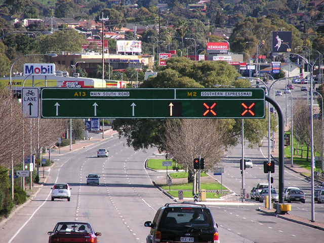
South Road and its southern section as Main South Road outside of Adelaide is a major north–south conduit connecting Adelaide and the Fleurieu Peninsula, in South Australia. It is one of Adelaide's most important arterial and bypass roads. As South Road, it is designated part of route A2 within suburban Adelaide, and as Main South Road, it is designated part of routes A13 and B23. The northern part of South Road contributes the central component of the North–South Corridor, a series of road projects under construction or planning that will eventually provide a continuous expressway between Old Noarlunga and Gawler. Route South Road commences from the intersection with Port River Expressway and Salisbury Highway in Wingfield and runs directly south, through much of Adelaide's inner western suburbs, close to the Adelaide city centre; it is complimented by (and in some instances, subsumed into) the North-South Motorway and either runs directly underneath it at ground level wi ... [...More Info...] [...Related Items...] OR: [Wikipedia] [Google] [Baidu] |
North-South Motorway
''North-South'' ( hy, Հյուսիս-Հարավ) or ''Four Buddies and the Bride'' is an Armenian comedy directed by Davit Babakhanyan and Vazgen Muradyan, starring Diana Malenko, Sona Shahgeldyan and David Tovmasyan. The film was produced by Lilit Martirosyan. Plot The film is about the friendship of four guys. One of them gets into trouble, but three friends help him out. Junior Researcher Nver receives a professional order from the oligarch Lambert Khachaturovich. Nver decides to seize the opportunity and organizes a party for his friends at the client's luxurious mansion. During the party, a statue of Lambert's father falls and breaks. Given the attitude of Lambert to the memory of his father, friends easily imagine the death of Nver. The guys create a "salvation plan", but they fail. Now they not only have to pay the cost of the statue, but also organize a luxurious wedding. But there is no prepayment, which they received for organizing the wedding, and the groom is out o ... [...More Info...] [...Related Items...] OR: [Wikipedia] [Google] [Baidu] |
Southern Expressway (Australia)
Southern Expressway is an freewayA guide to using the Southern Expressway Department of Planning, Transport and Infrastructure, Government of South Australia through the southern suburbs of , . It is the southern part of the North–South Corridor which extends the full length of Adelaide and is being built to urban freeway standard. It is designated part of route M2. The Southern ... [...More Info...] [...Related Items...] OR: [Wikipedia] [Google] [Baidu] |
North–South Motorway
The North–South Motorway is a partially complete motorway traversing the inner western suburbs of Adelaide from Waterloo Corner in the north to Bedford Park in the south. Progressively constructed in stages since 2010, once complete it will replace the adjacent South Road as Adelaide's main north–south roadway and form the central section of the North–South Corridor, being flanked north and south by the Northern Expressway and Southern Expressway, respectively. It is designated part of route M2. By March 2021, approximately of the motorway had been completed, with the remaining under investigation. The full project is planned for completion in 2030. Background In 2010, the Australian Government, through the Nation Building Program project, committed $500 million and the South Australian Government committed $432 million to the North–South Corridor over five years. This funding allocation recognised that South Road is the only continuous link between the northern ... [...More Info...] [...Related Items...] OR: [Wikipedia] [Google] [Baidu] |
Hindmarsh, South Australia
Hindmarsh is an inner Suburbs and localities (Australia), suburb of Adelaide, South Australia. It is located in the City of Charles Sturt. The suburb is located between South Road, Adelaide, South Road to the west and North Adelaide. The River Torrens forms its southern boundary and the Grange railway line, Grange and Outer Harbor railway line, Outer Harbour railway line forms the northeast. History Before the colonisation of South Australia in 1836, the land now called Hindmarsh was occupied by the Kaurna people. The suburb was named by South Australia's first Governors of South Australia, Governor, Sir John Hindmarsh. Hindmarsh was the first owner of section 353 in the Hundred of Yatala, being among the earliest to make a selection of a "country section" to which he and other early investors in South Australia were entitled by their purchase of land orders prior to settlement (see ''Lands administrative divisions of South Australia#Land division history, Lands administrati ... [...More Info...] [...Related Items...] OR: [Wikipedia] [Google] [Baidu] |
Wingfield, South Australia
Wingfield is a suburb situated north of Adelaide. It lies between the Port River Expressway on the north and Grand Junction Road on the south. The suburb borders Dry Creek to its north and east, bounded by the Gawler railway line and Adelaide-Port Augusta railway line on the east. The North-South Motorway and Dry Creek-Port Adelaide railway line both cross the suburb. Wingfield is named after R. W. Wingfield, the private secretary to Governor of South Australia, William Jervois. Government The suburb is in the City of Port Adelaide Enfield local government area. Major industries The southwestern corner of the suburb includes residential housing, however the majority of the suburb is industrial. Industry includes recycling, manufacturing and freight forwarding. Waste and resource recovery Wingfield is the site of the 94ha Wingfield Waste & Recycling Centre (commonly known as the Wingfield Tip or Wingfield Dump), formerly owned and operated by the Adelaide City Counci ... [...More Info...] [...Related Items...] OR: [Wikipedia] [Google] [Baidu] |
Waterloo Corner, South Australia
Waterloo Corner is a rural/urban suburb approximately 22 kilometres north of Adelaide, the capital city of South Australia. Most of the land is used for agricultural purposes, including wheat, olives, grapes and tomatoes. Port Wakefield Road Port Wakefield Highway (and its southern section as Port Wakefield Road) is an important South Australian highway, connecting Adelaide to the Yorke Peninsula, Port Augusta, northern and western South Australia, the Northern Territory and Wester ... runs through the suburb and thus much heavy freight traverses the suburb. Waterloo Corner Post Office closed in 1972. References Suburbs of Adelaide {{Adelaide-geo-stub ... [...More Info...] [...Related Items...] OR: [Wikipedia] [Google] [Baidu] |
Angle Vale
Angle Vale is a semi-rural town on the Adelaide Plains between Gawler and Virginia in South Australia. It is steadily being surrounded by Adelaide's suburban sprawl. It is close to many vineyards and farms. The town includes Trinity College's Gawler River campus, and Angle Vale Primary School, but no secondary school. Many students travel to nearby towns or to Gawler. Angle Vale Post Office opened on 1 October 1866. A Foodland supermarket opened in 2007, along with an assortment of other new stores, replacing an older shopping area. Part of this shopping area remains as a fruits and vegetables store. The laminated timber arch Angle Vale Bridge was constructed over the Gawler River in 1876, and is one of the oldest surviving bridges of its type. It is located just north of the center of town. The former Carclew Carclew House, one of Britain's lost houses, was a large Palladian country house near Mylor in Cornwall, England, United Kingdom. It was situated at approximate ... [...More Info...] [...Related Items...] OR: [Wikipedia] [Google] [Baidu] |


