|
List Of Bridges On The National Register Of Historic Places In Maine
This is a list of bridges and tunnels on the National Register of Historic Places in the U.S. state of Maine. Bridges removed from the register References {{NRHP bridges Bridges on the National Register of Historic Places in Maine, Lists of bridges on the National Register of Historic Places by state, Maine Maine transportation-related lists, Bridges Lists of buildings and structures in Maine, Bridges ... [...More Info...] [...Related Items...] OR: [Wikipedia] [Google] [Baidu] |
Bridge
A bridge is a structure built to span a physical obstacle (such as a body of water, valley, road, or rail) without blocking the way underneath. It is constructed for the purpose of providing passage over the obstacle, which is usually something that is otherwise difficult or impossible to cross. There are many different designs of bridges, each serving a particular purpose and applicable to different situations. Designs of bridges vary depending on factors such as the function of the bridge, the nature of the terrain where the bridge is constructed and anchored, and the material used to make it, and the funds available to build it. The earliest bridges were likely made with fallen trees and stepping stones. The Neolithic people built boardwalk bridges across marshland. The Arkadiko Bridge (dating from the 13th century BC, in the Peloponnese) is one of the oldest arch bridges still in existence and use. Etymology The '' Oxford English Dictionary'' traces the origin of ... [...More Info...] [...Related Items...] OR: [Wikipedia] [Google] [Baidu] |
Bennett Bridge
The Bennett Bridge is a historic covered bridge in rural northern Oxford County, Maine. The bridge, now closed to traffic, formerly carried Littlehale Road over the Magalloway River, about south of the village Wilsons Mills in Lincoln Plantation. Built in 1901, it is one of Maine's few older covered bridges.National Register nomination for Bennett Bridge; available by request from the National Park Service The bridge was listed on the National Register of Historic Places in 1970. Description The bridge is a Paddleford truss bridge, a type of truss in which diagonal cross members are connected to King posts, fastened by metal bolts. It is in length, resting on granite abutments. Its total width is 16'8", with an interior roadway width of 14'8". Its total height is (from roadbed to top of gable), with a portal clearance of . Its sides are clad in vertical boarding roughly 2/3 of the way to the roof; the ends are also clad in vertical boarding above and around the portals. ... [...More Info...] [...Related Items...] OR: [Wikipedia] [Google] [Baidu] |
Lebanon, Maine
Lebanon is a town in York County, Maine, United States. The population was 6,469 at the 2020 census. Lebanon includes the villages of Center Lebanon, West Lebanon, North Lebanon, South Lebanon and East Lebanon. It is the westernmost town in Maine. Lebanon is part of the Portland– South Portland–Biddeford, Maine metropolitan statistical area. Lebanon Airport is home to Skydive New England. History It was called Towwoh by the Newichawannock Abenaki tribe, whose main village was further down the Salmon Falls River. On April 20, 1733, the Massachusetts General Court granted Towwoh Plantation to 60 colonists, who first settled it in 1743. The township was incorporated on June 17, 1767, renamed Lebanon after the biblical land of Lebanon. It was Maine's 23rd town. Lebanon annexed unincorporated land in 1785, and some from Sanford in 1787. It swapped land with Shapleigh, giving some in 1793, then annexing some in 1825. Farmers found the surface of the town relatively leve ... [...More Info...] [...Related Items...] OR: [Wikipedia] [Google] [Baidu] |
Grist Mill Bridge (Lebanon, Maine)
The Grist Mill Bridge is a historic bridge in Lebanon, Maine, carrying Little River Road across the Little River. Although the bridge has a 20th-century wooden deck on rubblestone abutments and pier, it is functionally similar to the bridge's original deck, which was also a wooden structure that may have existed as early as 1774. The bridge was listed on the National Register of Historic Places as a rare example of a bridge in the state with some essential 18th-century elements intact. Description and history The Grist Mill Bridge is located in a rural part of far eastern Lebanon. The Little River Road runs generally southward, roughly following the course of the eponymous river as it makes its way south to the Salmon Falls River in Berwick. A short way south of the Lebanon-North Berwick Baptist Church, the road crosses the river at a point where it makes an S-shaped bend to the west. Just downstream (west) of the bridge stands the Old Grist Mill, which was built in 1774. D ... [...More Info...] [...Related Items...] OR: [Wikipedia] [Google] [Baidu] |
Buckfield, Maine
Buckfield is a town in Oxford County, Maine, United States. Buckfield is included in the Lewiston-Auburn, Maine metropolitan New England City and Town Area. It is a member of Regional School Unit 10 along with nearby Hartford and Sumner. The town had a population of 1,983 as of the 2020 census. History It was first settled in 1776 by Benjamin Spaulding from Chelmsford, Massachusetts, a fur trapper. Abijah Buck and Thomas Allen settled in the area in spring of 1777 with their families. In 1785, the inhabitants procured a survey of the town and purchased it from Massachusetts for 2 shillings per acre. Originally called Bucktown Plantation (or Plantation No. 5), in 1793 the Massachusetts General Court incorporated it as Buckfield, named for Abijah Buck. The surface of the town is uneven, but has deep, dark soil that yielded good crops of grain, corn and apples. The east and west branches of the Nezinscot River join at Buckfield Village, supplying water power for mills. Produc ... [...More Info...] [...Related Items...] OR: [Wikipedia] [Google] [Baidu] |
Churchill Bridge
The Churchill Bridge is a historic bridge carrying Mountain Road over Bicknell Brook, in a rural corner of Buckfield, Maine. It is one of three documented stone lintel bridges in the state. It is a dry laid rubble stone structure which carries the road over the stream at a height of about . The total length of the bridge is about , and the clear span over the brook is . The span is formed by five massive ledge stones laid on rubble abutments about above the stream. Additional rubble is laid above to form the bed of the gravel roadway. The bridge crosses the stream at a slight angle, so its abutments are extended with wingwalls to the northwest and southeast. The bridge is believed to have been built around 1797 by William Churchill, whose homestead was located nearby. He apparently built the bridge in exchange for a tax abatement from the town. The town owns the bridge and is responsible for its maintenance. The bridge is a rare survivor; a 1924 survey identified 20 stone ... [...More Info...] [...Related Items...] OR: [Wikipedia] [Google] [Baidu] |
Hancock County, Maine
Hancock County is a county located in the U.S. state of Maine. As of the 2020 census, the population was 55,478. Its county seat is Ellsworth. The county was incorporated on June 25, 1789, and named for John Hancock, the first governor of the Commonwealth of Massachusetts. Geography According to the U.S. Census Bureau, the county has a total area of , of which is land and (32%) is water. The county high point is Cadillac Mountain, 1527 feet, the highest summit on the U.S. Atlantic seaboard. Adjacent counties * Penobscot County — north * Washington County — northeast *Waldo County — west * Knox County — southwest Demographics 2000 census As of the census of 2000, there were 51,791 people, 21,864 households, and 14,233 families living in the county. The population density was 33 people per square mile (13/km2). There were 33,945 housing units at an average density of 21 per square mile (8/km2). The racial makeup of the county was 97.61% White, 0.25% Bla ... [...More Info...] [...Related Items...] OR: [Wikipedia] [Google] [Baidu] |
Acadia National Park, Maine
Acadia National Park is an American national park located along the mid-section of the Maine coast, southwest of Bar Harbor, Maine, Bar Harbor. The park preserves about half of Mount Desert Island, part of the Isle au Haut, the tip of the Schoodic Peninsula, and portions of 16 smaller outlying islands. It protects the natural beauty of the rocky headlands, including the highest mountains along the Atlantic coast. Acadia boasts a glaciated coastal and island landscape, an abundance of habitats, a high level of biodiversity, clean air and water, and a rich cultural heritage. The park contains the tallest mountain on the Atlantic Coast of the United States (Cadillac Mountain), exposed granite domes, glacial erratics, U-shaped valleys, and Cobble (geology), cobble beaches. Its mountains, lakes, streams, wetlands, forests, meadows, and coastlines contribute to a diversity of plants and animals. Weaved into this landscape is a Acadia National Park carriage paths, bridges and gatehouse ... [...More Info...] [...Related Items...] OR: [Wikipedia] [Google] [Baidu] |
Acadia Bridge
Acadia (french: link=no, Acadie) was a colony of New France in northeastern North America which included parts of what are now the Maritime provinces, the Gaspé Peninsula and Maine to the Kennebec River. During much of the 17th and early 18th centuries, Norridgewock on the Kennebec River and Castine at the end of the Penobscot River were the southernmost settlements of Acadia. The French government specified land bordering the Atlantic coast, roughly between the 40th and 46th parallels. It was eventually divided into British colonies. The population of Acadia included the various indigenous First Nations that comprised the Wabanaki Confederacy, the Acadian people and other French settlers. The first capital of Acadia was established in 1605 as Port-Royal. An English force from Virginia attacked and burned down the town in 1613, but it was later rebuilt nearby, where it remained the longest-serving capital of French Acadia until the British siege of Port Royal in 1710. Th ... [...More Info...] [...Related Items...] OR: [Wikipedia] [Google] [Baidu] |
Acadia National Park Carriage Paths, Bridges And Gatehouses
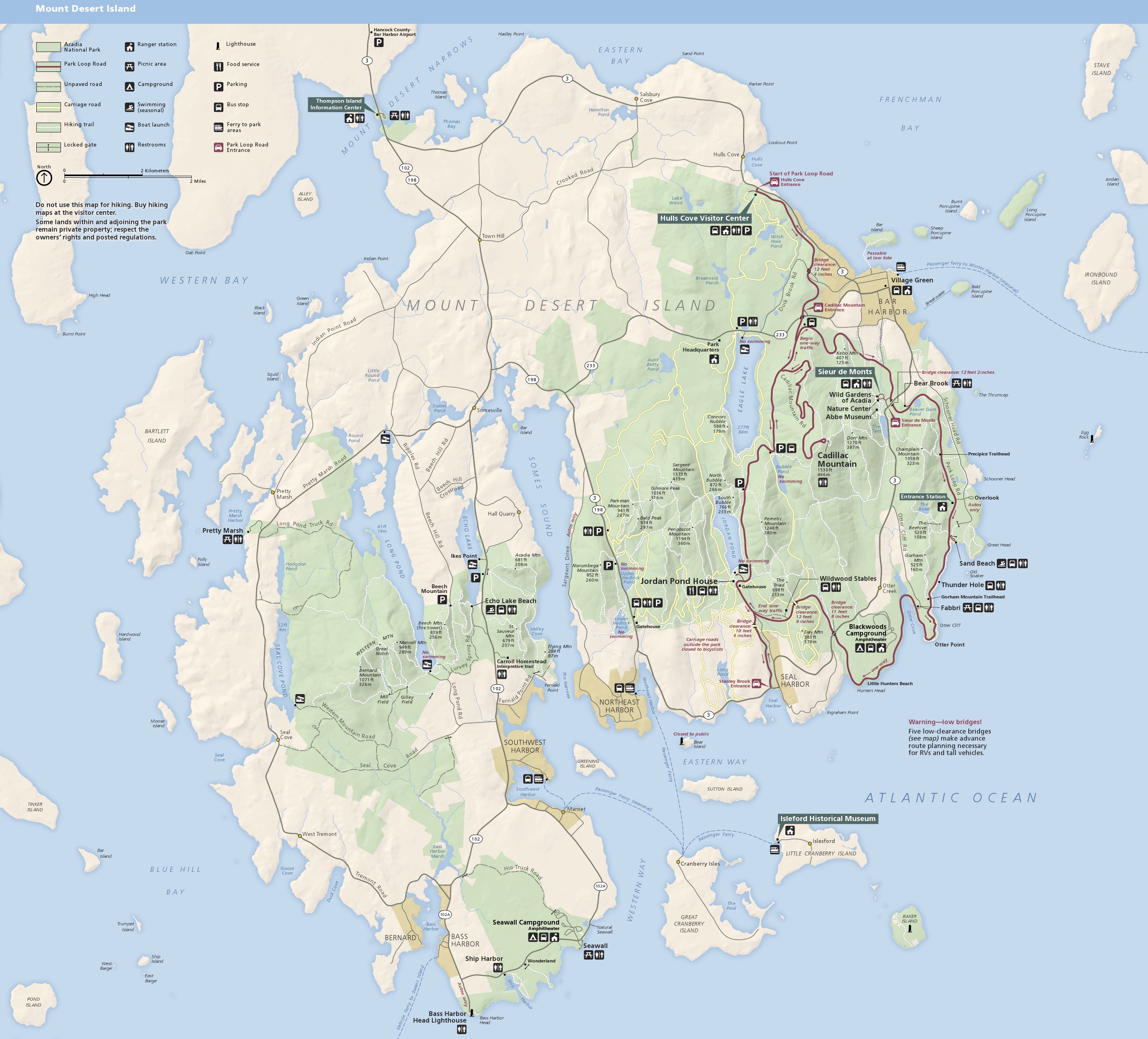
Acadia National Park, largely on Mount Desert Island, off the coast of the U.S. state of Maine, was created in part by land and other donations by John D. Rockefeller Jr. Between 1919 and 1931, Rockefeller, who was opposed to the introduction of automobiles on the island, personally oversaw the construction of a network of carriage roads, closed to motorized vehicles, on the eastern half of the island, including sixteen granite bridges and two gatehouses. The major portion of this network now falls within the bounds of the national park, and was listed on the National Register of Historic Places in 1979. The network of carriage roads is open to the public for non-motorized uses in the summer, including walking and bicycling. In the winter, most of the network is open to cross-country skiing, and a portion of it is open to snowmobiling. History Beginning in about 1890, Mount Desert Island became a summer resort haven for a number of wealthy families, including the Rockefellers, ... [...More Info...] [...Related Items...] OR: [Wikipedia] [Google] [Baidu] |


