|
List Of Indian Reservations In Arizona
This is a list of Native American reservations in the U.S. state of Arizona. List of reservations See also * Indigenous peoples of Arizona * Fort Apache Indian Reservation * List of federally recognized tribes in Arizona * List of cities and towns in Arizona * List of counties in Arizona References {{DEFAULTSORT:List Of Indian Reservations in Arizona Indian Reservations Indian reservations An Indian reservation is an area of land held and governed by a federally recognized Native American tribal nation whose government is accountable to the United States Bureau of Indian Affairs and not to the state government in which i ... Indian reservations, Arizona ... [...More Info...] [...Related Items...] OR: [Wikipedia] [Google] [Baidu] |
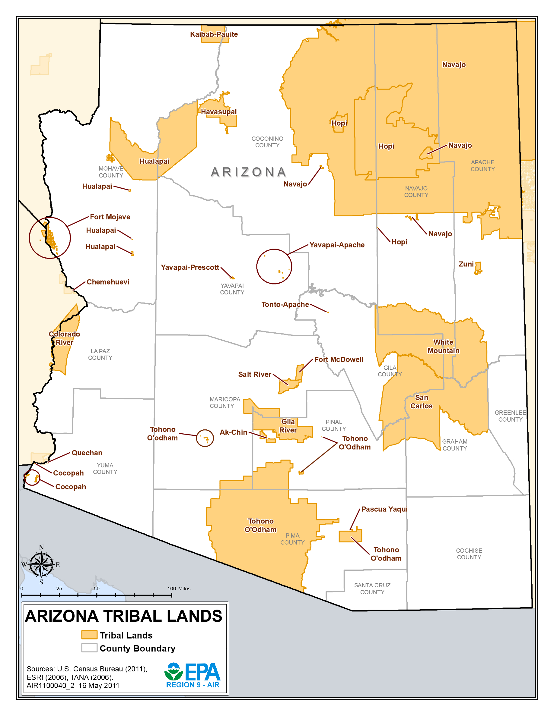
Arizona Tribal Lands
Arizona ( ; nv, Hoozdo Hahoodzo ; ood, Alĭ ṣonak ) is a state in the Southwestern United States. It is the 6th largest and the 14th most populous of the 50 states. Its capital and largest city is Phoenix. Arizona is part of the Four Corners region with Utah to the north, Colorado to the northeast, and New Mexico to the east; its other neighboring states are Nevada to the northwest, California to the west and the Mexican states of Sonora and Baja California to the south and southwest. Arizona is the 48th state and last of the contiguous states to be admitted to the Union, achieving statehood on February 14, 1912. Historically part of the territory of in New Spain, it became part of independent Mexico in 1821. After being defeated in the Mexican–American War, Mexico ceded much of this territory to the United States in 1848. The southernmost portion of the state was acquired in 1853 through the Gadsden Purchase. Southern Arizona is known for its desert cli ... [...More Info...] [...Related Items...] OR: [Wikipedia] [Google] [Baidu] |
California
California is a state in the Western United States, located along the Pacific Coast. With nearly 39.2million residents across a total area of approximately , it is the most populous U.S. state and the 3rd largest by area. It is also the most populated subnational entity in North America and the 34th most populous in the world. The Greater Los Angeles area and the San Francisco Bay Area are the nation's second and fifth most populous urban regions respectively, with the former having more than 18.7million residents and the latter having over 9.6million. Sacramento is the state's capital, while Los Angeles is the most populous city in the state and the second most populous city in the country. San Francisco is the second most densely populated major city in the country. Los Angeles County is the country's most populous, while San Bernardino County is the largest county by area in the country. California borders Oregon to the north, Nevada and Arizona to the ea ... [...More Info...] [...Related Items...] OR: [Wikipedia] [Google] [Baidu] |
Gila River Indian Community
The Gila River Indian Community (GRIC) (O'odham language: Keli Akimel Oʼotham, ''meaning "Gila River People"'', Maricopa language: Pee-Posh) is an Indian reservation in the U.S. state of Arizona, lying adjacent to the south side of the city of Phoenix, within the Phoenix Metropolitan Area in Pinal and Maricopa counties. Gila River Indian Reservation was established in 1859, and the Gila River Indian Community formally established by Congress in 1939. The community is home for members of both the Akimel O’odham (Pima) and the Pee-Posh (Maricopa) tribes. The reservation has a land area of and a 2020 Census population of 14,260. It is made up of seven districts along the Gila River and its largest communities are Sacaton, Komatke, Santan, and Blackwater. Tribal administrative offices and departments are located in Sacaton. The Community operates its own telecom company, electric utility, industrial park and healthcare clinic, and publishes a monthly newspaper. It has ... [...More Info...] [...Related Items...] OR: [Wikipedia] [Google] [Baidu] |
Imperial County, California
Imperial County is a county on the southeast border of the U.S. state of California. As of the 2020 census, the population was 179,702, making it the least populous county in Southern California. The county seat is El Centro. Imperial is the most recent California county to be established, as it was created in 1907 out of portions of San Diego County. Imperial County is located in the far southeast of California, in the Imperial Valley. It borders San Diego County to the west, Riverside County to the north, the U.S. state of Arizona to the east and the Mexican state of Baja California to the south. It includes the El Centro Metropolitan Statistical Area and is part of the Southern California border region, the smallest but most economically diverse region in the state. Although this region is a desert, with high temperatures and low average rainfall of per year, the economy is strongly based on agriculture. This is supported by irrigation, with water supplied wholly fro ... [...More Info...] [...Related Items...] OR: [Wikipedia] [Google] [Baidu] |
Quechan
The Quechan (or Yuma) ( Quechan: ''Kwatsáan'' 'those who descended') are a Native American tribe who live on the Fort Yuma Indian Reservation on the lower Colorado River in Arizona and California just north of the Mexican border. Despite their name, they are not related to the Quechua people of the Andes. Members are enrolled into the Quechan Tribe of the Fort Yuma Indian Reservation. The federally recognized Quechan tribe's main office is located in Winterhaven, California. Its operations and the majority of its reservation land are located in California, United States. History The historic Yuman-speaking people in this region were skilled warriors and active traders, maintaining exchange networks with the Pima in southern Arizona, New Mexico, and with peoples of the Pacific coast. The first significant contact of the Quechan with Europeans was with the Spanish explorer Juan Bautista de Anza and his party in the winter of 1774. Relations were friendly. On Anza's retur ... [...More Info...] [...Related Items...] OR: [Wikipedia] [Google] [Baidu] |
Fort Yuma Indian Reservation
The Fort Yuma Indian Reservation is a part of the traditional lands of the Quechan people. Established in 1884 from the former Fort Yuma, the reservation, at , has a land area of in southeastern Imperial County, California, and western Yuma County, Arizona, near the city of Yuma, Arizona. Both the county and city are named for the tribe. As of the 2010 Census the population was 2,189. In 1910, the community of Bard, California Bard is an unincorporated community in Imperial County, California, United States, located along County Route S24. It lies at an elevation of 138 feet (42 m). Bard is home to the Imperial Date Gardens. Bard was created in 1910 after the eas ..., was created after the eastern part of the reservation was declared surplus under the Dawes Act. In 2009, the Quechan Tribe opened a large gaming resort, the Quechan Casino Resort, on their reservation land. References {{authority control Quechan American Indian reservations in Arizona Ame ... [...More Info...] [...Related Items...] OR: [Wikipedia] [Google] [Baidu] |
Clark County, Nevada
Clark County is located in the U.S. state of Nevada. As of the 2020 census, the population was 2,265,461. Most of the county population resides in the Las Vegas Census County Divisions, which hold 1,771,945 people as of the 2010 Census, across . It is by far the most populous county in Nevada, and the 11th most populous county in the United States. It covers 7% of the state's land area but holds 74% of the state's population, making Nevada one of the most centralized states in the United States. History Las Vegas, the state's most populous city, has been the county seat since its establishment. The county was formed by the Nevada Legislature by splitting off a portion of Lincoln County on February 5, 1909, and was organized on July 1, 1909. The Las Vegas Valley, a basin, includes Las Vegas and other major cities and communities such as North Las Vegas, Henderson, and the unincorporated community of Paradise. Native Americans lived in the Las Vegas Valley beginning ove ... [...More Info...] [...Related Items...] OR: [Wikipedia] [Google] [Baidu] |
Nevada
Nevada ( ; ) is a state in the Western region of the United States. It is bordered by Oregon to the northwest, Idaho to the northeast, California to the west, Arizona to the southeast, and Utah to the east. Nevada is the 7th-most extensive, the 32nd-most populous, and the 9th-least densely populated of the U.S. states. Nearly three-quarters of Nevada's people live in Clark County, which contains the Las Vegas–Paradise metropolitan area, including three of the state's four largest incorporated cities. Nevada's capital is Carson City. Las Vegas is the largest city in the state. Nevada is officially known as the "Silver State" because of the importance of silver to its history and economy. It is also known as the "Battle Born State" because it achieved statehood during the Civil War (the words "Battle Born" also appear on its state flag); as the " Sagebrush State", for the native plant of the same name; and as the " Sage-hen State". The name means "snowy" in Spanish, ... [...More Info...] [...Related Items...] OR: [Wikipedia] [Google] [Baidu] |
Mohave County
Mohave County is in the northwestern corner of the U.S. state of Arizona. As of the 2020 census, its population was 213,267. The county seat is Kingman, and the largest city is Lake Havasu City. It is the fifth largest county in the United States (by area). Mohave County includes the Lake Havasu City–Kingman, Arizona Metropolitan Statistical Area, which is also included in the Las Vegas- Henderson, Nevada-Arizona Combined Statistical Area. Mohave County contains parts of Grand Canyon National Park and Lake Mead National Recreation Area and all of the Grand Canyon–Parashant National Monument. The Kaibab, Fort Mojave and Hualapai Indian Reservations also lie within the county. History Mohave County was the one of four original Arizona Counties created by the 1st Arizona Territorial Legislature. The county territory was originally defined as being west of longitude 113° 20' and north of the Bill Williams River. Pah-Ute County was created from it in 1865 and was merged ba ... [...More Info...] [...Related Items...] OR: [Wikipedia] [Google] [Baidu] |
Fort Mojave Indian Reservation
The Fort Mohave Indian Reservation is an Indian reservation along the Colorado River, currently encompassing in Arizona, in California, and in Nevada. The reservation is home to approximately 1,100 members of the federally recognized Fort Mojave Indian Tribe of Arizona, California, and Nevada ( mov, Pipa Aha Macav), a federally recognized tribe of Mohave people. Native Americans occupy less than 50 percent of the Mojave reservation. The Mohave people have leased much of their land to cotton, corn, and soybean farming companies, which employ a large population of resident European-Americans and Mexican Americans. The site of the former Fort Mohave and the eastern terminus of the Mojave Road are situated within the Fort Mojave Indian Reservation. History These lands were occupied for thousands of years by succeeding cultures of Indigenous peoples. The property covers areas along the Colorado River of the three adjacent states of Arizona, California, and Nevada. It also is sporad ... [...More Info...] [...Related Items...] OR: [Wikipedia] [Google] [Baidu] |
Maricopa County
Maricopa County is in the south-central part of the U.S. state of Arizona. As of the 2020 census, the population was 4,420,568, making it the state's most populous county, and the fourth-most populous in the United States. It contains about 62% of Arizona's population, making Arizona one of the most centralized states in the nation. The county seat is Phoenix, the state capital and fifth-most populous city in the United States. Maricopa County is the central county of the Phoenix- Mesa-Chandler, AZ Metropolitan Statistical Area. The Office of Management and Budget renamed the metropolitan area in September 2018. Previously, it was the Phoenix-Mesa-Glendale metropolitan area, and in 2000, that was changed to Phoenix-Mesa-Scottsdale. Maricopa County was named after the Maricopa Native Americans. Five Native American Reservations are located in the county. The largest are the Salt River Pima-Maricopa Indian Community (east of Scottsdale) and the Gila River Indian Comm ... [...More Info...] [...Related Items...] OR: [Wikipedia] [Google] [Baidu] |
Yavapai People
The Yavapai are a Native American tribe in Arizona. Historically, the Yavapai – literally “people of the sun” (from ''Enyaava'' “sun” + ''Paay'' “people”) – were divided into four geographical bands who identified as separate, independent peoples: the Ɖulv G’paaya, or Western Yavapai; the Yaavpe', or Northwestern Yavapai; the Gwev G’paaya, or Southeastern Yavapai; and the Wiipukpaa, or Northeastern Yavapai – Verde Valley Yavapai. Another Yavapai band, which no longer exists, was the Mađqwarrpaa or "Desert People." Its people are believed to have mixed with the Mojave and Quechan peoples. The Yavapai have much in common with their linguistic relatives to the north, the Havasupai and the Hualapai. Often the Yavapai were mistaken as Apache by American settlers, who referred to them as "Mohave-Apache," "Yuma-Apache," or "Tonto-Apache". Before the 1860s, when settlers began exploring for gold in the area, the Yavapai occupied an area of approximately 20, ... [...More Info...] [...Related Items...] OR: [Wikipedia] [Google] [Baidu] |


.jpg)


.png)
