|
List Of Valleys Of Arizona
This is a list of valleys of Arizona. Valleys are ordered alphabetically, by county. Apache County B * Bat Canyon * Beautiful Valley C * Chinle Valley, Chinle, Arizona M * Monument Valley R * Red Rock Valley W * Windy Valley (Arizona) Cochise County C * Cienega Valley (Arizona) S * San Bernardino Valley * San Pedro Valley (Arizona), San Pedro River (Arizona) * San Simon Valley * Sulphur Springs Valley Coconino County A * Aubrey Valley C * Chino Valley (Arizona) L Gila County S * Salt River Valley Graham County A * Aravaipa Valley, Aravaipa Creek G * Gila River Valley * Gila Valley (Graham County) W * Whitlock Valley, Whitlock Mountains La Paz County B * Butler Valley (Arizona) L * Lower Colorado River Valley M * McMullen Valley P * Palo Verde Valley, (also Imperial & Riverside Counties, CA), Palo Verde Mountains, (CA) * Parker Valley Maricopa County A * Aguila Valley C * Childs Valley * Citrus Valley D * Dendora Valley G * Gila River Valley * Growler Valle ... [...More Info...] [...Related Items...] OR: [Wikipedia] [Google] [Baidu] |
Arizona Relief NED
Arizona ( ; nv, Hoozdo Hahoodzo ; ood, Alĭ ṣonak ) is a U.S. state, state in the Southwestern United States. It is the list of U.S. states and territories by area, 6th largest and the list of U.S. states and territories by population, 14th most populous of the 50 states. Its capital city, capital and List of largest cities, largest city is Phoenix, Arizona, Phoenix. Arizona is part of the Four Corners region with Utah to the north, Colorado to the northeast, and New Mexico to the east; its other neighboring states are Nevada to the northwest, California to the west and the List of states of Mexico, Mexican states of Sonora and Baja California (state), Baja California to the south and southwest. Arizona is the 48th state and last of the contiguous United States, contiguous states to be admitted to the Union, achieving statehood on February 14, 1912. Historically part of the territory of in New Spain, it became part of independent Mexico in 1821. After being defeated in th ... [...More Info...] [...Related Items...] OR: [Wikipedia] [Google] [Baidu] |
Sulphur Springs Valley
The Sulphur Springs Valley is a valley in the eastern half of Cochise County, Arizona. The valley covers an approximated vertical rectangle west of the Chiricahua Mountains–Dos Cabezas Mountains complex. The Sulphur Springs Valley is the large flatland to the west. Geography The valley gets its name from two sulfur springs located there. Drainage is from north to south, with a moderately sized endorheic basin, named the Willcox Playa, occupying the northern area. The southern portion of the valley drains into Mexico through Douglas, Arizona through Agua Prieta, Sonora, and into the Yaqui River. During plentiful rain the mountain foothills contain plentiful grasslands. The region is otherwise an arid part of the northeastern Sonoran Desert, influenced by the Chihuahuan Desert just southeast in New Mexico and northwest Chihuahua. The highest mountain areas of this southeast Arizona section contains Madrean Sky Islands of mountain sky islands. Sulphur Springs Valley is one ... [...More Info...] [...Related Items...] OR: [Wikipedia] [Google] [Baidu] |
La Paz County, Arizona
La Paz County is the 15th county in the U.S. state of Arizona, located in the western part of the state. As of the 2020 census, its population was 16,557, making it the second-least populous county in Arizona. The county seat is Parker. The name of the county is the Spanish word for "the peace", and is taken from the early settlement (now ghost town) of La Paz along the Colorado River. History La Paz County was established in 1983 after voters approved separating the northern portion of Yuma County, making it the only county to be established after Arizona became a state in 1912, and currently the second youngest county in the United States (behind the consolidated city-county of Broomfield, Colorado, which was established in 2001). The county did not have a large enough tax base to begin supporting a separate county government immediately and had to rely on state money at first. As a result, Arizona laws were changed to make splitting other existing counties much more d ... [...More Info...] [...Related Items...] OR: [Wikipedia] [Google] [Baidu] |
Whitlock Mountains
Whitlock may refer to: __NOTOC__ Places * Whitlock, Tennessee, United States, an unincorporated community * Whitlock Valley, Arizona, United States * Whitlock Island, Western Australia * Whitlock, original name of Bay Terrace station, a railway station in Bay Terrace, Staten Island, New York, United States * Whitlock's End, a hamlet in Dickens Heath parish, West Midlands, England ** Whitlocks End railway station People * Whitlock (surname), people with the surname * Whitlock Nicoll Whitlock Nicoll or Nicholl (1786–1838) was an English physician. Known in his lifetime as a medical and theological writer, he was also responsible in his capacity as physician to Michael Faraday for the term "electrode", a fact not known unti ... (1786–1838), English physician Businesses * Whitlock (manufacturing), a former London-based carriage and automobile manufacturer * F. Whitlock & Sons Ltd, pickle and sauce manufacturers {{disambig, geo ... [...More Info...] [...Related Items...] OR: [Wikipedia] [Google] [Baidu] |
Whitlock Valley
The Whitlock Valley is a small valley in southeast Graham County, Arizona, southwestern United States, lying between three mountain ranges. The valley lies on the south perimeter region of the White Mountains in eastern Arizona, and lies south of the west-flowing Gila River, and the region transitions south into Cochise County and three large valleys, with some scattered dry lakes. The valley is endorheic, with a small dry lake called Parks Lake, and merges southwest into the north of the San Simon Valley, where the San Simon River has its origins in the flatlands, and surrounding perimeter mountains. The valley was named after Captain James H. Whitlock who commanded during the Battle of Mount Gray in 1864 which was fought near the valley. Description Regional endorheic valley The west-flowing Gila River is forced into a NW-West-SW excursion by the small range of the Black Hills (Greenlee County). The Whitlock Valley drains south from the range, and merges into the north of the ... [...More Info...] [...Related Items...] OR: [Wikipedia] [Google] [Baidu] |
Gila Valley (Graham County)
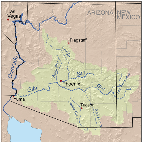
The Gila River Valley is a multi-sectioned valley of the Gila River, located primarily in Arizona. The Gila River forms in western New Mexico and flows west across southeastern, south-central, and southwestern Arizona; it changes directions as it progresses across the state, and defines specific areas and valleys. The central portion of the river flows through the southern Phoenix valley region (the '' Salt River Valley'' joins the Gila River Valley in this area), and the final sections in southwestern Arizona form smaller, irrigated valleys, such as Dome Valley, Mohawk Valley, and Hyder Valley. Two mountain ranges are named for the Gila River: the Gila Mountains (Graham County) bordering the Gila River Valley, northeast of Safford; the Gila Mountains (Yuma County) border the Gila River Valley before the Gila River joins its confluence with the Colorado River; that range is east of Yuma and the Fortuna Foothills. Graham County The Gila Valley begins as a 35-mile (56 km) ... [...More Info...] [...Related Items...] OR: [Wikipedia] [Google] [Baidu] |
Gila River Valley
The Gila River Valley is a multi-sectioned valley of the Gila River, located primarily in Arizona. The Gila River forms in western New Mexico and flows west across southeastern, south-central, and southwestern Arizona; it changes directions as it progresses across the state, and defines specific areas and valleys. The central portion of the river flows through the southern Phoenix valley region (the '' Salt River Valley'' joins the Gila River Valley in this area), and the final sections in southwestern Arizona form smaller, irrigated valleys, such as Dome Valley, Mohawk Valley, and Hyder Valley. Two mountain ranges are named for the Gila River: the Gila Mountains (Graham County) bordering the Gila River Valley, northeast of Safford; the Gila Mountains (Yuma County) border the Gila River Valley before the Gila River joins its confluence with the Colorado River; that range is east of Yuma and the Fortuna Foothills. Graham County The Gila Valley begins as a 35-mile (56 km) ... [...More Info...] [...Related Items...] OR: [Wikipedia] [Google] [Baidu] |
Aravaipa Creek
Aravaipa Creek is a drainage between three mountain ranges in southwest Graham County, Arizona – the Galiuro Mountains, the Santa Teresa Mountains and the Pinaleno Mountains. These mountains are part of the high altitude Madrean Sky Islands located in southern Arizona and New Mexico in the United States, and northern Sonora and Chihuahua states in Mexico. Aravaipa Creek originates on the southeast flank of the Galiuro Mountains at Durkee Canyon and Blue Peak at .Arizona Road and Recreation Atlas, pp. 82–83. It then flows northwest through the narrow, fault-blocked Aravaipa Valley with the Pinaleno Mountains bordering the valley on the east and the Santa Teresa Mountains bordering on the northeast. On the west side of the valley, the creek follows the northeast and north perimeter of the Galiuro Mountains massif flowing northwest, west, and then southwest through and around the range's north end to meet the San Pedro River a few miles south of Dudleyville. The town of K ... [...More Info...] [...Related Items...] OR: [Wikipedia] [Google] [Baidu] |
Aravaipa Valley
Aravaipa Creek is a drainage between three mountain ranges in southwest Graham County, Arizona – the Galiuro Mountains, the Santa Teresa Mountains and the Pinaleno Mountains. These mountains are part of the high altitude Madrean Sky Islands located in southern Arizona and New Mexico in the United States, and northern Sonora and Chihuahua states in Mexico. Aravaipa Creek originates on the southeast flank of the Galiuro Mountains at Durkee Canyon and Blue Peak at .Arizona Road and Recreation Atlas, pp. 82–83. It then flows northwest through the narrow, fault-blocked Aravaipa Valley with the Pinaleno Mountains bordering the valley on the east and the Santa Teresa Mountains bordering on the northeast. On the west side of the valley, the creek follows the northeast and north perimeter of the Galiuro Mountains massif flowing northwest, west, and then southwest through and around the range's north end to meet the San Pedro River a few miles south of Dudleyville. The town of K ... [...More Info...] [...Related Items...] OR: [Wikipedia] [Google] [Baidu] |
Graham County, Arizona
Graham County is a county in the southeastern part of the U.S. state of Arizona. As of the 2020 census, the population was 38,533, making it the third-least populous county in Arizona. The county seat is Safford. Graham County composes the Safford, Arizona Micropolitan Statistical Area. The county is home to several organizations including Eastern Arizona College and the Mount Graham International Observatory, which includes one of the world's largest and most powerful telescopes. Graham County is also home to the Arizona Salsa Trail and the annual Salsa Fest. Graham County contains part of the San Carlos Apache Indian Reservation. History Joseph Knight Rogers, an early settler in the area, and a member of the Arizona Territorial Legislature, is known as the father of Graham County. He introduced the bill in the territorial legislature creating Graham County. Graham County was created from southern Apache County and eastern Pima County on March 10, 1881. Initially, the co ... [...More Info...] [...Related Items...] OR: [Wikipedia] [Google] [Baidu] |
Salt River Valley
The Salt River Valley is an extensive valley on the Salt River in central Arizona, which contains the Phoenix Metropolitan Area. Although this geographic term still identifies the area, the name "Valley of the Sun" popularly replaced the usage starting in the early 1930s for purposes of boosterism. A common dust for testing air filter efficiency was derived from top soil dust from the Salt River Valley, referred to as Arizona Dust. The dust was found to include small abrasive particles. File:Salt River Map.jpg, Graphic of the "Salt River Drainage", the Mogollon Rim, and the Arizona transition zone The Arizona transition zone is a diagonal northwest-by-southeast region across central Arizona. The region is a transition from the higher-elevation Colorado Plateau in Northeast Arizona and the Basin and Range region of lower-elevation deserts ... (central-west region) References {{Coord, 33.3811546, -112.3129333, display=title River valleys of the United States Valley ... [...More Info...] [...Related Items...] OR: [Wikipedia] [Google] [Baidu] |
Gila County, Arizona
Gila County ( ) is in the central part of the U.S. state of Arizona. As of the 2020 census, the population was 53,272. The county seat is Globe. Gila County comprises the Payson, Arizona Micropolitan Statistical Area. Gila County contains parts of Fort Apache Indian Reservation and San Carlos Indian Reservation. History The county was formed from parts of Maricopa and Pinal counties on February 8, 1881. The boundary was then extended eastward to the San Carlos River by public petition in 1889. The original county seat was in the mining community of Globe City, now Globe. Popular theory holds that the word "Gila" was derived from a Spanish contraction of Hah-quah-sa-eel, a Yuma word meaning "running water which is salty". In the 1880s, a long range war broke out in Gila County that became the most costly feud in American history, resulting in an almost complete annihilation of the families involved. The ''Pleasant Valley War'' (also sometimes called the ''Tonto Basin Fe ... [...More Info...] [...Related Items...] OR: [Wikipedia] [Google] [Baidu] |


