|
List Of Extant Pinfolds In Cheshire
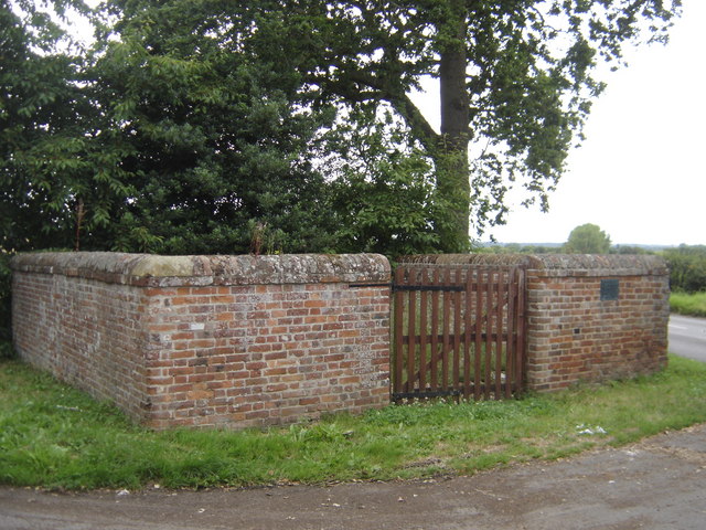
A pinfold was a structure into which straying animals were placed until they were retrieved by their owner on payment of a fine. Other terms for the structure were ''penfold'' or ''pound''. These names were derived from the Old English words ''pund'' (pound) and ''fuld'' (fold). In Cheshire, most of these were square or circular stone structures, although there is a circular pinfold in Henbury Henbury is a suburb of Bristol, England, approximately north west of the city centre. It was formerly a village in Gloucestershire and is now bordered by Westbury-on-Trym to the south; Brentry to the east and the Blaise Castle Estate, Blaise Ha .... There is evidence of the existence of at least 153 pinfolds in Cheshire, although, as of 2010, only eight of these remain in the current county of Cheshire. There are also the remains of four other pinfolds in the county. Key References ;Bibliography * External links {{DEFAULTSORT:Pinfolds in Cheshire Agricultural ... [...More Info...] [...Related Items...] OR: [Wikipedia] [Google] [Baidu] |
Hoole Village
Hoole Village is a village and former civil parish near Chester, in the unitary authority of Cheshire West and Chester and the ceremonial county of Cheshire, England. The civil parish was abolished in 2015 to form Mickle Trafford and District, part of it also went to Guilden Sutton. The parish contained the southern end of the M53 motorway where it becomes the A55 road and is crossed by the A56 road. This junction is known as Hoole Island Junction. Also in the village is Hoole Hall, which is now a hotel. In 2004 the population was 230, rising to 319 at the time of the 2011 census. History In September 1955 a prehistoric arrowhead and a worked flake were found in a garden in the parish. The arrowhead was dated to the period between the Early Bronze Age and the Early Iron Age (2350 BC to 701 BC). In 1995 aerial photography showed evidence of a Roman practice fort near to Hoole Hall. It is believed that the Roman road from Chester to Wilderspool (now part of Warrington) passed ... [...More Info...] [...Related Items...] OR: [Wikipedia] [Google] [Baidu] |
Buildings And Structures In Cheshire
A building, or edifice, is an enclosed structure with a roof and walls standing more or less permanently in one place, such as a house or factory (although there's also portable buildings). Buildings come in a variety of sizes, shapes, and functions, and have been adapted throughout history for a wide number of factors, from building materials available, to weather conditions, land prices, ground conditions, specific uses, prestige, and aesthetic reasons. To better understand the term ''building'' compare the list of nonbuilding structures. Buildings serve several societal needs – primarily as shelter from weather, security, living space, privacy, to store belongings, and to comfortably live and work. A building as a shelter represents a physical division of the human habitat (a place of comfort and safety) and the ''outside'' (a place that at times may be harsh and harmful). Ever since the first cave paintings, buildings have also become objects or canvasses of much artistic ... [...More Info...] [...Related Items...] OR: [Wikipedia] [Google] [Baidu] |
Agricultural Buildings In England
Agriculture or farming is the practice of cultivating plants and livestock. Agriculture was the key development in the rise of sedentary human civilization, whereby farming of domesticated species created food surpluses that enabled people to live in cities. The history of agriculture began thousands of years ago. After gathering wild grains beginning at least 105,000 years ago, nascent farmers began to plant them around 11,500 years ago. Sheep, goats, pigs and cattle were domesticated over 10,000 years ago. Plants were independently cultivated in at least 11 regions of the world. Industrial agriculture based on large-scale monoculture in the twentieth century came to dominate agricultural output, though about 2 billion people still depended on subsistence agriculture. The major agricultural products can be broadly grouped into foods, Fiber, fibers, fuels, and raw materials (such as Natural rubber, rubber). Food classes include Cereal, cereals (grains), Vegetable, vegetab ... [...More Info...] [...Related Items...] OR: [Wikipedia] [Google] [Baidu] |
Tarvin
Tarvin is a village in the unitary authority of Cheshire West and Chester and the ceremonial county of Cheshire, England. It had a population of 2,693 people at the 2001 UK census, rising to 2,728 at the 2011 Census, and the ward covers about . Location and context Tarvin is about east of Chester. The current parish covers Tarvin, Duddon, Clotton, Stapleford, Burton, Hoofield and Oscroft. There are currently 28 listed buildings in Tarvin (one Grade I Listed, two Grade II* Listed, and twenty-five Grade II Listed). The centre of the village is a Conservation Area that was created in 1972, and much of the land surrounding the village is designated Green Belt. Geology The Cheshire Plain (sometimes known as the Cheshire Gap) is a relatively flat expanse of lowland, which supports agricultural use for dairy farming on the medium-scale pastoral fields that surround the village. Tarvin is west of a sandstone ridge that divides the Cheshire Plain. The River Gowy passes to the so ... [...More Info...] [...Related Items...] OR: [Wikipedia] [Google] [Baidu] |
Shocklach
Shocklach is a village in the civil parish of Shocklach Oviatt and District, in the Cheshire West and Chester district, in the county of Cheshire, England. Shocklach village is in the southwestern corner of Cheshire, approximately from the border between Wales and England, the River Dee. The village lies between Wrexham, to the west, and Nantwich, to the east. Demographics In the 1870s, Shocklach was described as being "on River Dee, 4½ miles N W. of Malpas, 2957 ac., pop. 325; the par. contains the townships of Shocklach Church, 1278 ac., pop. 135, and Shocklach Oviatt, 1848 ac., pop. 135". Shocklach had a population of 290 according to the 2011 census. History Firstly, there is history behind the name of the village. According to the ''Concise Oxford Dictionary of English Place Names'', the village name Shocklach means 'goblin stream'. Investigating this meaning further, the old English (according to the ''Oxford English Dictionary'') for goblin "was scucca and lac ... [...More Info...] [...Related Items...] OR: [Wikipedia] [Google] [Baidu] |
Pinfold Poole Bank
An animal pound is a place where stray livestock were impounded. Animals were kept in a dedicated enclosure, until claimed by their owners, or sold to cover the costs of impounding. Etymology The terms "pinfold" and "pound" are Saxon in origin. ''Pundfald'' and ''pund'' both mean an enclosure. There appears to be no difference between a pinfold and a village pound. The person in charge of the pinfold was the "pinder", giving rise to the surname ''Pinder''. Village pound or pinfold The village pound was a feature of most English medieval villages, and they were also found in the English colonies of North America and in Ireland. A high-walled and lockable structure served several purposes; the most common use was to hold stray sheep, pigs and cattle until they were claimed by the owners, usually for the payment of a fine or levy. The pound could be as small as or as big as and may be circular or square. Early pounds had just briar hedges, but most were built in stone or ... [...More Info...] [...Related Items...] OR: [Wikipedia] [Google] [Baidu] |
Poole, Cheshire
Poole is a civil parish in the unitary authority of Cheshire East and the ceremonial county of Cheshire, England, which lies to the north west of Nantwich and to the west of Crewe. The Shropshire Union Canal runs through the parish. Nearby villages include Acton, Aston juxta Mondrum, Barbridge, Stoke Bank, Rease Heath and Worleston. The civil parish is largely rural with scattered farms and buildings, and a total population of around 90 in 2006. At the time of the 2011 Census the population of the civil parish remained less than 100. Details are included in the civil parish of Worleston. History Poole was a late Saxon village; the name derives from the Saxon ''Pol'', meaning a pool. Two holdings were recorded in the Domesday survey of 1086, with a total population of 9, greater than any of the surrounding manors except Acton. A coppice or small wood was recorded. Before the Norman Conquest, it was held by Wulfeva, described as "a free woman", and afterwards by Willi ... [...More Info...] [...Related Items...] OR: [Wikipedia] [Google] [Baidu] |
Bickerton, Cheshire
Bickerton is a village and civil parish in the unitary authority of Cheshire East and the ceremonial county of Cheshire, England, about north of Whitchurch in Shropshire. The parish also includes the small settlement of Gallantry Bank,Genuki: Bickerton (accessed 21 February 2008) with a total population of over 200. The two s also lie partly within the civil parish. History  Bickerton appears in the
|
Wardle, Cheshire
Wardle is a village and civil parish in the unitary authority of Cheshire East and the ceremonial county of Cheshire, England. The village lies on the Shropshire Union Canal, north west of Barbridge Junction (at ), and is 4 miles to the north west of Nantwich, and the parish also includes part of the small settlement of Wardle Bank. The total population is around 250. RAF Calveley was a flight-training station during the Second World War, and the Mark III radio telescope stood on the airfield site in 1966–96. The modern civil parish includes Wardle Industrial Estate and is otherwise largely agricultural. Nearby villages include Barbridge, Calveley and Haughton. History Watfield Pavement, a stone road believed to have originally formed part of a Roman road from Chester to Chesterton in Staffordshire, passed through or adjacent to the parish,King ''et al''. 1778, p. 263 and a bronze Roman coin was found nearby. Wardle appears in the Domesday Book of 1086 as "Warhelle" ... [...More Info...] [...Related Items...] OR: [Wikipedia] [Google] [Baidu] |
Sutton Lane Ends
Sutton Lane Ends or Sutton is a semi-rural village and civil parish, approximately one mile south of Macclesfield. In 2020 it had an estimated population of 936. The parish includes the villages of Langley and Oakgrove and the hamlets of Gurnett, Jarman and Lyme Green. Sutton is in the unitary authority of Cheshire East and the ceremonial county of Cheshire, England. The rivers Bollin and Rosendale run through Sutton Lane Ends, as does the Macclesfield Canal. The population of the entire civil parish is 2,464.2001 census details Accessed 15 May 2007. In the past, the community was centred on farming, forestry and textiles; however, since these industries declined, most of the population now travel to nearby Macclesf ... [...More Info...] [...Related Items...] OR: [Wikipedia] [Google] [Baidu] |
Pinfold And Old Road Sign Near Little Budworth - Geograph
An animal pound is a place where stray livestock were impounded. Animals were kept in a dedicated enclosure, until claimed by their owners, or sold to cover the costs of impounding. Etymology The terms "pinfold" and "pound" are Saxon in origin. ''Pundfald'' and ''pund'' both mean an enclosure. There appears to be no difference between a pinfold and a village pound. The person in charge of the pinfold was the "pinder", giving rise to the surname ''Pinder''. Village pound or pinfold The village pound was a feature of most English medieval villages, and they were also found in the English colonies of North America and in Ireland. A high-walled and lockable structure served several purposes; the most common use was to hold stray sheep, pigs and cattle until they were claimed by the owners, usually for the payment of a fine or levy. The pound could be as small as or as big as and may be circular or square. Early pounds had just briar hedges, but most were built in stone or ... [...More Info...] [...Related Items...] OR: [Wikipedia] [Google] [Baidu] |


