|
List Of Civil Parishes In Dorset ...
This is a list of civil parishes in the ceremonial county of Dorset, England. There are 269 civil parishes. Bournemouth, Christchurch and Poole The former Bournemouth County Borough was mostly unparished and the former Poole Municipal Borough was entirely unparished. Dorset The former Weymouth and Melcombe Regis Municipal Borough was unparished. Population figures are unavailable for some of the smallest parishes. See also * List of civil parishes in England References External links Office for National Statistics : Geographical Area Listings {{Dorset Civil parishes Dorset Civil parishes In England, a civil parish is a type of administrative parish used for local government. It is a territorial designation which is the lowest tier of local government below districts and counties, or their combined form, the unitary authority. ... [...More Info...] [...Related Items...] OR: [Wikipedia] [Google] [Baidu] |
Civil Parish
In England, a civil parish is a type of administrative parish used for local government. It is a territorial designation which is the lowest tier of local government below districts and counties, or their combined form, the unitary authority. Civil parishes can trace their origin to the ancient system of ecclesiastical parishes, which historically played a role in both secular and religious administration. Civil and religious parishes were formally differentiated in the 19th century and are now entirely separate. Civil parishes in their modern form came into being through the Local Government Act 1894, which established elected parish councils to take on the secular functions of the parish vestry. A civil parish can range in size from a sparsely populated rural area with fewer than a hundred inhabitants, to a large town with a population in the tens of thousands. This scope is similar to that of municipalities in Continental Europe, such as the communes of France. However, ... [...More Info...] [...Related Items...] OR: [Wikipedia] [Google] [Baidu] |
Abbotsbury
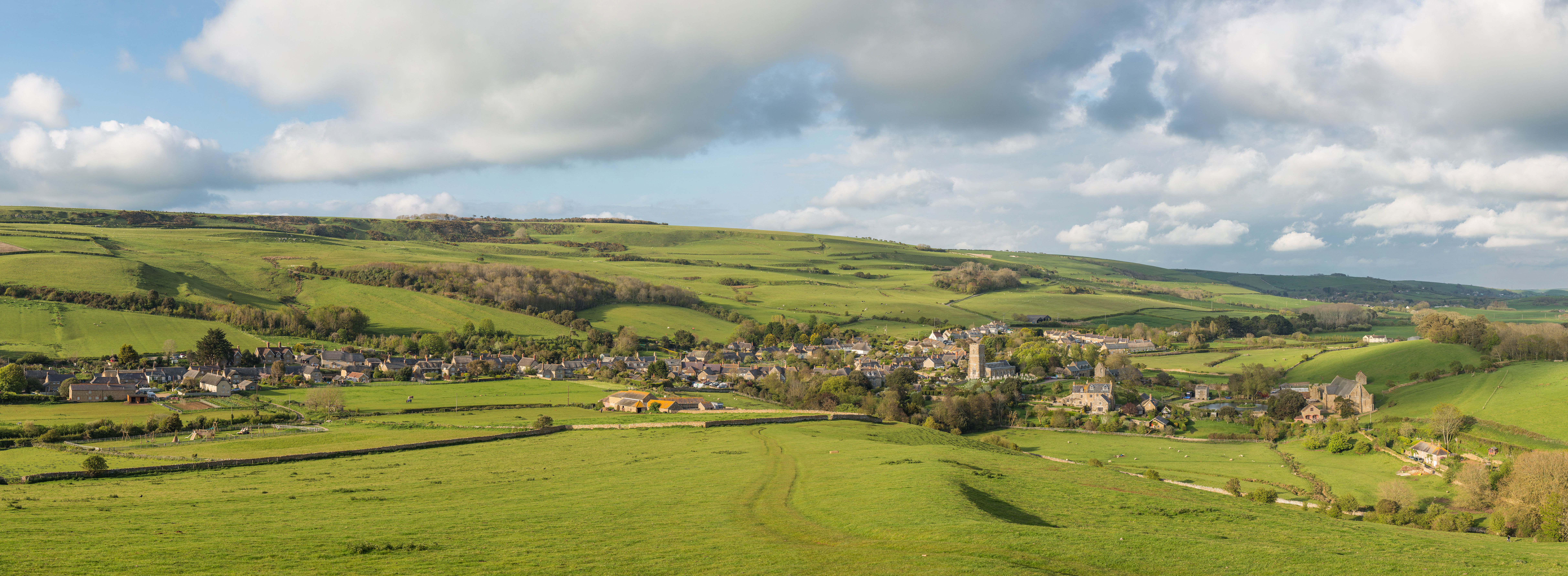
Abbotsbury is a village and civil parish in the English county of Dorset. The settlement is in the unitary authority of Dorset about inland from the English Channel coast. The village, including Chesil Beach, the swannery and subtropical gardens, is owned by the Ilchester Estate, which owns of land in Dorset. In the 2011 census the civil parish had a population of 481. The coastline within the parish of Abbotsbury includes a section of long Chesil Beach that is part of the Jurassic Coast, a World Heritage Site. Abbotsbury is known for its swannery, subtropical gardens and surviving abbey buildings, including St Catherine's Chapel, a 14th-century pilgrimage chapel that stands on a hill between the village and the coast. Geography Abbotsbury village is in the Dorset unitary authority administrative area, situated amidst hills about inland from the English Channel coast at Chesil Beach, an barrier beach which south of the village encloses The Fleet, a brackish coast ... [...More Info...] [...Related Items...] OR: [Wikipedia] [Google] [Baidu] |
Blandford Rural District
Blandford Forum ( ), commonly Blandford, is a market town in Dorset, England, sited by the River Stour about northwest of Poole. It was the administrative headquarters of North Dorset District until April 2019, when this was abolished and its area incorporated into the new Dorset unitary authority. Blandford is notable for its Georgian architecture, the result of rebuilding after the majority of the town was destroyed by a fire in 1731. The rebuilding work was assisted by an Act of Parliament and a donation by George II, and the rebuilt town centre—to designs by local architects John and William Bastard—has survived to the present day largely intact. Blandford Camp, a military base, is sited on the hills north-east of the town. It is the base of the Royal Corps of Signals, the communications wing of the British Army, and the site of the Royal Signals Museum. Dorset County Council estimates that in 2013 the town's civil parish had a population of 10,610. The t ... [...More Info...] [...Related Items...] OR: [Wikipedia] [Google] [Baidu] |
Anderson, Dorset
Anderson, sometimes known as Winterborne Anderson, is a small village and civil parish in Dorset, England, situated in the North Dorset administrative district about northwest of Poole. To the west are Winterborne Muston and Winterborne Kingston Winterborne Kingston is a village and civil parish in the county of Dorset in southern England. It lies south of the town of Blandford Forum and northeast of the large village of Bere Regis. It is situated in a winterbourne valley on the ed ... and to the east are Winterborne Tomson (which is also within Anderson parish) and Winterborne Zelston. In 2013 the estimated population of the parish was 60. Anderson Manor was built for the third John Tregonwell of Milton Abbas in 1622. It is constructed out of dark red brick with bands of vitrified headers. The civil parish was formed in 1933, following the merger of Winterborne Anderson and Winterborne Tomsom. References External links Villages in Dorset {{D ... [...More Info...] [...Related Items...] OR: [Wikipedia] [Google] [Baidu] |
Alton Pancras
Alton Pancras is a small village and civil parish in Dorset, England. In the 2011 census the civil parish had a population of 175. The village church is dedicated to Saint Pancras, which provides part of the village name. The parish was formerly a liberty, containing only the parish itself. History Evidence of prehistoric human activity within the parish includes two round barrows on the hills to the east of the village (one on West Hill and one on Church Hill), the remains of 'Celtic' fields and strip lynchets on many of the surrounding hills, and a possible settlement just south of the summit of Church Hill. Dating is not definite but the 'Celtic' fields were probably in use between the Bronze Age and the end of the Romano-British period. The possible settlement is probably Romano-British. Subsequent cultivation, particularly in modern times, has destroyed much of the evidence. The village itself was likely first settled by Saxons during the expansion of the Kingdom of ... [...More Info...] [...Related Items...] OR: [Wikipedia] [Google] [Baidu] |
Bridport Rural District
Bridport is a market town in Dorset, England, inland from the English Channel near the confluence of the River Brit and its tributary the Asker. Its origins are Saxon and it has a long history as a rope-making centre. On the coast and within the town's boundary is West Bay, a small fishing harbour also known as Bridport Harbour. The town features as Port Bredy in Thomas Hardy's Wessex novels. In the 21st century, Bridport's arts scene has expanded with an arts centre, theatre, cinema and museum. In the 2011 census the population of Bridport's built-up area was 13,568. The town is twinned with Saint-Vaast-la-Hougue, France. History Bridport's origins are Saxon. During the reign of King Alfred it became one of the four most important settlements in Dorset – the other three being Dorchester, Shaftesbury and Wareham – with the construction of fortifications and establishment of a mint. Bridport's name probably derives from another location nearby. In the ... [...More Info...] [...Related Items...] OR: [Wikipedia] [Google] [Baidu] |
Allington, Dorset
Allington is a village and civil parish in Dorset, England, north-west from the town of Bridport, with which it is physically contiguous; much of Allington lies within Bridport parish. In the 2011 census Allington civil parish had 371 dwellings, 339 households and a population of 766. Allington Hill rises to above the village; it is managed by the Woodland Trust. The hill is characteristic of the Upper Greensand hills and ridges found in the Marshwood and Powerstock Vales National Character Area. In 1086 in the Domesday Book Allington was recorded as ''Adelingtone''; it had 21 households, 3 ploughlands, of meadow and one mill. It was in Goderthorn Hundred and the lord and tenant-in-chief was Turstin son of Rolf. The parish church at North Allington, dedicated to St Swithun, was designed by Charles Wallis of Dorchester and built in 1826–27, and is a Grade II* listed building In the United Kingdom, a listed building or listed structure is one that has been placed ... [...More Info...] [...Related Items...] OR: [Wikipedia] [Google] [Baidu] |
East Dorset
East Dorset was a Non-metropolitan district, local government district in Dorset, England. Its council met in Wimborne Minster between 2016 and 2019. The district (as Wimborne) was formed on 1 April 1974 by merging Wimborne Minster Urban District with Wimborne and Cranborne Rural District, plus the parish of St Ives, Dorset, St Leonards and St Ives transferred from the Ringwood and Fordingbridge Rural District in Hampshire. The district was renamed East Dorset with effect from 1 January 1988. The district was abolished in 2019 at the same time that Dorset County Council and the other districts in the county were abolished, with the area becoming part of the Dorset (district), Dorset unitary authority on 1 April 2019. The popularity of the area, being close to the New Forest, Bournemouth and the Dorset coast saw a rapid expansion in housing from the 1970s with the Verwood, Ferndown, West Moors and Corfe Mullen populations more than quadrupling. Rural landscape prevailed in the ... [...More Info...] [...Related Items...] OR: [Wikipedia] [Google] [Baidu] |
Wimborne And Cranborne Rural District
Wimborne Minster (often referred to as Wimborne, ) is a market town in Dorset in South West England, and the name of the Church of England church in that town. It lies at the confluence of the River Stour and the River Allen, north of Poole, on the Dorset Heaths, and is part of the South East Dorset conurbation. According to Office for National Statistics data the population of the Wimborne Minster built-up area was 15,552. Governance The town and its administrative area are served by eleven councillors plus one from the nearby ward of Cranfield. The electoral ward of Wimborne Minster is slightly bigger than the parish, with a 2011 population of 7,014. Wimborne Minster is part of the Mid Dorset and North Poole parliamentary constituency. Buildings and architecture Wimborne has one of the foremost collections of 15th-, 16th- and 17th-century buildings in Dorset. Local planning has restricted the construction of new buildings in areas such as the Cornmarket and t ... [...More Info...] [...Related Items...] OR: [Wikipedia] [Google] [Baidu] |
Alderholt
Alderholt is a large village and civil parish in east Dorset, England; situated west of Fordingbridge. The parish includes the hamlets of Crendell and Cripplestyle. The local travel links are located from the village to Salisbury railway station and to Bournemouth International Airport. The main road running through the village is the B3078 connecting Alderholt to Fordingbridge and Shaftesbury. The village has a population of 3,113 according to the 2001 Census, increasing along with the electoral ward of the same name to 3,171 at the 2011 Census. The village is served by a small Co-operative store, (previously a Spar, until early 2007), veterinary clinic and part-time GP surgery. The village pub iThe Churchill Arms There are three churches in the village: Alderholt Chapel, St James' Church of England, and the Tabernacle Gospel Church. Until mid-2014, Alderholt also had its own independent pet store. The village also has a large recreation ground with a sports and social clu ... [...More Info...] [...Related Items...] OR: [Wikipedia] [Google] [Baidu] |
Purbeck (district)
Purbeck was a Non-metropolitan district, local government district in Dorset, England. The district was named after the Isle of Purbeck, a peninsula that forms a large proportion of the district's area. However, it extended significantly further north and west than the traditional boundary of the Isle of Purbeck which is the River Frome, Dorset, River Frome. The district council was based in the town of Wareham, Dorset, Wareham, which is itself north of the Frome. The district was formed under the Local Government Act 1972 on 1 April 1974, from the former municipal borough of Wareham, Swanage Urban district (Great Britain and Ireland), urban district and Wareham and Purbeck Rural District. The district and its council were abolished on 1 April 2019, together with the other four districts outside the greater Bournemouth area, to form a new Dorset (unitary authority), Dorset unitary authority. Its name is recorded in 948 AD as Old English, Anglo-Saxon ''Purbicinga'', meaning "of th ... [...More Info...] [...Related Items...] OR: [Wikipedia] [Google] [Baidu] |
Wareham And Purbeck Rural District
{{d ...
Wareham may refer to: Places * Wareham, Dorset, England * Wareham, Massachusetts, United States, a town * Wareham, Minnesota, United States, an abandoned townsite * Wareham, Newfoundland and Labrador, Canada * Wareham, Ontario, Canada * Wareham Island, Nunavut, Canada People * Andrew Wareham, British historian * Arthur Wareham, British newspaper editor * Dave Wareham, American basketball player * Dean Wareham, New York-based musician with Galaxie 500, Luna, Dean and Britta * Jack Wareham, English footballer * Louise Wareham Leonard, American author * Nicholas Wareham, British epidemiologist * Pete Wareham, London-based saxophonist with Acoustic Ladyland, Polar Bear, Melt Yourself Down See also * Warham (other) Warham may refer to: ;Places * Warham, Herefordshire, England * Warham, Norfolk, England ;People * Joe Warham - English rugby league footballer, coach and administrator * John Warham - New Zealand ornithologist * William Warham (1450-1532) - Arch ... [...More Info...] [...Related Items...] OR: [Wikipedia] [Google] [Baidu] |


