|
List Of Breweries In Iowa
Breweries in Iowa produce a wide range of beers in different styles that are marketed locally and regionally. Brewing companies vary widely in the volume and variety of beer produced, from small nanobreweries to microbreweries to massive multinational conglomerate macrobreweries. Iowa is a state located in the Midwestern United States, an area often referred to as the "American Heartland". In 2012 Iowa's 38 breweries and brewpubs employed 140 people directly, and more than 12,000 others in related jobs such as wholesaling and retailing. Including people directly employed in brewing, as well as those who supply Iowa's breweries with everything from ingredients to machinery, the total business and personal tax revenue generated by Iowa's breweries and related industries was more than $230 million. Consumer purchases of Iowa's brewery products generated more than $100 million additional tax revenue. In 2012, according to the Brewers Association, Iowa ranked 15th in the number of cra ... [...More Info...] [...Related Items...] OR: [Wikipedia] [Google] [Baidu] |
Dubuque Star Brewery
The Dubuque Star Brewery, located in Dubuque, Iowa, is a building that for many years made Dubuque Star beers. The brewery is located just north of the Ice Harbor in Dubuque. It was listed on the National Register of Historic Places in 2007. with History Dubuque Star was established by Joseph Rhomberg in 1898. Until the beginning of Prohibition, the brewery produced Dubuque Star beer. As with many other breweries, the Dubuque Star brewery was forced to close down. Before Prohibition, there were 138 breweries in the state, but afterwards Dubuque Star was the only small brewery left in the state. With the repeal of Prohibition in 1933, the brewery was reopened. Because of its location near the Mississippi River, when the river flooded it would often cause problems for the brewery. The 1965 floods were particularly bad. The brewery operators made protective measures for the river reaching 23 feet, but the river soon reached 26 feet. This caused serious damage to the lower f ... [...More Info...] [...Related Items...] OR: [Wikipedia] [Google] [Baidu] |
Ames, Iowa
Ames () is a city in Story County, Iowa, United States, located approximately north of Des Moines in central Iowa. It is best known as the home of Iowa State University (ISU), with leading agriculture, design, engineering, and veterinary medicine colleges. A United States Department of Energy national laboratory, Ames Laboratory, is located on the ISU campus. According to the 2020 census, Ames had a population of 66,427, making it the state's ninth largest city. Iowa State University was home to 33,391 students as of fall 2019, which make up approximately one half of the city's population. Ames also hosts United States Department of Agriculture (USDA) sites: the largest federal animal disease center in the United States, the USDA Agricultural Research Service's National Animal Disease Center (NADC), as well as one of two national USDA sites for the Animal and Plant Health Inspection Service (APHIS), which comprises the National Veterinary Services Laboratory and the Center for ... [...More Info...] [...Related Items...] OR: [Wikipedia] [Google] [Baidu] |
Waverly, Iowa
Waverly is a city in Bremer County, Iowa, United States. The population was 10,394 at the time of the 2020 census. It is the county seat of Bremer County and is part of the Waterloo– Cedar Falls Metropolitan Statistical Area. The sister city of Waverly is the German city of Eisenach, which is famous for the Wartburg castle. Waverly is the location of Wartburg College, which is named after this castle. Early Waverly history Indian reservation The first permanent residents of Waverly were settled there against their will. Because of their alleged assistance given to Chief Black Hawk during the Blackhawk War of 1832, the Winnebago were forced to cede their lands east of the Mississippi and to move to Neutral Ground in what is now northeastern Iowa. They were to receive $270,000 ($10,000 per year for 27 years) and were required to surrender several of their tribesmen accused of murdering whites during the war. At that time there were three tribes living in the area, the Win ... [...More Info...] [...Related Items...] OR: [Wikipedia] [Google] [Baidu] |
Boone, Iowa
Boone ( ) is a city in Des Moines Township, Boone County, Iowa, Des Moines Township, and county seat of Boone County, Iowa, Boone County, Iowa, United States. It is the principal city of the Boone, Iowa Micropolitan Statistical Area, which encompasses all of Boone County. This micropolitan statistical area, along with the Ames, Iowa Metropolitan Statistical Area comprise the larger Ames-Boone, Iowa Combined Statistical Area. The population of the city was 12,460 at the 2020 United States Census, 2020 census. History Coal mining played an important part in the early history of the Boone area. Local blacksmiths were already mining coal from the banks of Honey Creek south of what became Boone in 1849. Boone was platted as a town in 1865 by John Insley Blair. It was incorporated the following year, when the Chicago and North Western Transportation Company railroad station was built there. The town was originally named "Montana"; it was renamed to Boone in 1871. The nearby town of B ... [...More Info...] [...Related Items...] OR: [Wikipedia] [Google] [Baidu] |
Inwood, Iowa
Inwood is a city in Lyon County, Iowa, United States. The population was 928 at the time of the 2020 census. Geography Inwood's longitude and latitude coordinates in decimal form are 43.308770, -96.432531. According to the United States Census Bureau, the city has an area of , all land. Demographics 2010 census As of the census of 2010, there were 814 people, 341 households, and 236 families living in the city. The population density was . There were 373 housing units at an average density of . The racial makeup of the city was 97.9% White, 0.1% Native American, 0.1% Asian, 1.2% from other races, and 0.6% from two or more races. Hispanic or Latino of any race were 1.4% of the population. There were 341 households, of which 27.3% had children under the age of 18 living with them, 61.9% were married couples living together, 4.1% had a female householder with no husband present, 3.2% had a male householder with no wife present, and 30.8% were non-families. 27.3% of all househol ... [...More Info...] [...Related Items...] OR: [Wikipedia] [Google] [Baidu] |
Central City, Iowa
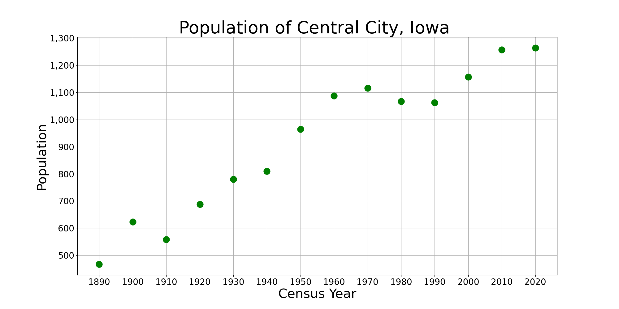
Central City is a city in Linn County, Iowa, United States. The population was 1,264 at the 2020 census. It is part of the Cedar Rapids Metropolitan Statistical Area. History Central City was founded in the 1850s. The name Central City refers to its location within proximity to railroads. A section of the downtown area has been listed on the National Register of Historic Places as the Central City Commercial Historic District. Geography Central City is located at (42.204544, -91.525013). According to the United States Census Bureau, the city has a total area of , of which is land and is water. Demographics 2010 census As of the census of 2010, there were 1,257 people, 522 households, and 351 families living in the city. The population density was . There were 556 housing units at an average density of . The racial makeup of the city was 98.3% White, 0.6% African American, 0.2% Native American, 0.2% Asian, 0.1% from other races, and 0.6% from two or more races. Hispani ... [...More Info...] [...Related Items...] OR: [Wikipedia] [Google] [Baidu] |
Solon, Iowa
Solon is a city located in Johnson County, Iowa, Johnson County, Iowa, United States. Part of the Iowa City, Iowa, Iowa City, Iowa Iowa City metropolitan area, Metropolitan Statistical Area, it is located a few miles from Lake MacBride State Park and the larger cities of Coralville, Iowa, Coralville and Iowa City. The population was 3,018 at the time of the 2020 United States Census, 2020 census. History Solon was platted in 1840. It is named for the classical Athenian statesman, lawmaker, and lyric poet Solon. Ironically, the local high school's mascot is the Spartans; Sparta was famously an enemy of Athens, Solon's home. The National Register of Historic Places-listed Stone Academy (Solon, Iowa), Stone Academy is just north of town. Geography According to the United States Census Bureau, the city has a total area of , all land. Demographics 2010 census As of the census of 2010, there were 2,037 people, 759 households, and 528 families living in the city. The population densit ... [...More Info...] [...Related Items...] OR: [Wikipedia] [Google] [Baidu] |
Iowa City, Iowa
Iowa City, offically the City of Iowa City is a city in Johnson County, Iowa, United States. It is the home of the University of Iowa and county seat of Johnson County, at the center of the Iowa City Metropolitan Statistical Area. At the time of the 2020 census the population was 74,828, making it the state's fifth-largest city. The metropolitan area, which encompasses Johnson and Washington counties, has a population of over 171,000. The Iowa City Metropolitan Statistical Area (MSA) is also a part of a Combined Statistical Area (CSA) with the Cedar Rapids MSA. This CSA plus two additional counties are known as the Iowa City-Cedar Rapids region which collectively has a population of nearly 500,000. Iowa City was the second capital of the Iowa Territory and the first capital city of the State of Iowa. The Old Capitol building is a National Historic Landmark in the center of the University of Iowa campus. The University of Iowa Art Museum and Plum Grove, the home of the firs ... [...More Info...] [...Related Items...] OR: [Wikipedia] [Google] [Baidu] |
Des Moines, Iowa
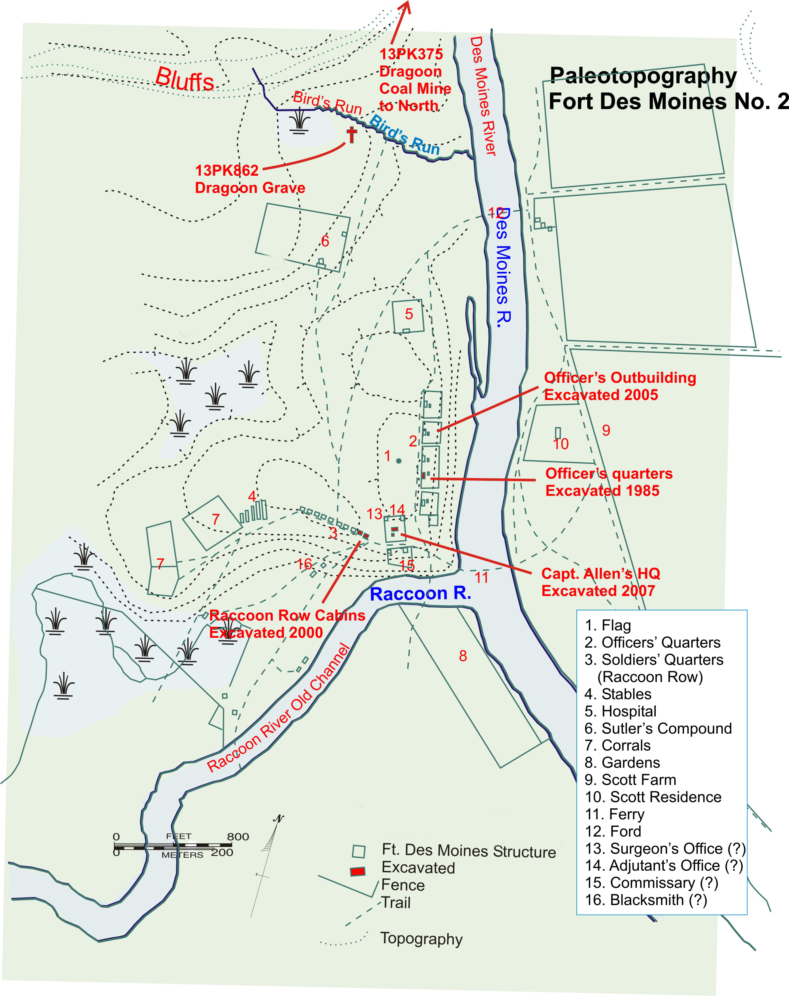
Des Moines () is the capital and the most populous city in the U.S. state of Iowa. It is also the county seat of Polk County. A small part of the city extends into Warren County. It was incorporated on September 22, 1851, as Fort Des Moines, which was shortened to "Des Moines" in 1857. It is located on, and named after, the Des Moines River, which likely was adapted from the early French name, ''Rivière des Moines,'' meaning "River of the Monks". The city's population was 214,133 as of the 2020 census. The six-county metropolitan area is ranked 83rd in terms of population in the United States with 699,292 residents according to the 2019 estimate by the United States Census Bureau, and is the largest metropolitan area fully located within the state. Des Moines is a major center of the US insurance industry and has a sizable financial services and publishing business base. The city was credited as the "number one spot for U.S. insurance companies" in a ''Business Wire'' articl ... [...More Info...] [...Related Items...] OR: [Wikipedia] [Google] [Baidu] |
Belle Plaine, Iowa
Belle Plaine is a city in Benton County, Iowa, United States. The population was 2,330 at the 2020 United States Census, 2020 census. It is part of the Cedar Rapids, Iowa, Cedar Rapids Cedar Rapids metropolitan area, Metropolitan Statistical Area. History Belle Plaine was founded in 1862 when it was certain the railroad would be extended to that point. "Belle Plaine" is derived from the French meaning "beautiful plain". Belle Plaine is located on both the historic Lincoln Highway and the cross country tracks of the Union Pacific Railroad. Geography According to the United States Census Bureau, the city has a total area of , of which is land and is water. The Iowa River flows roughly southeastward, just south of the city airport. Demographics 2010 census As of the census of 2010, there were 2,534 people, 1,101 households, and 659 families living in the city. The population density was . There were 1,258 housing units at an average density of . The racial makeup of the city ... [...More Info...] [...Related Items...] OR: [Wikipedia] [Google] [Baidu] |
Burlington, Iowa
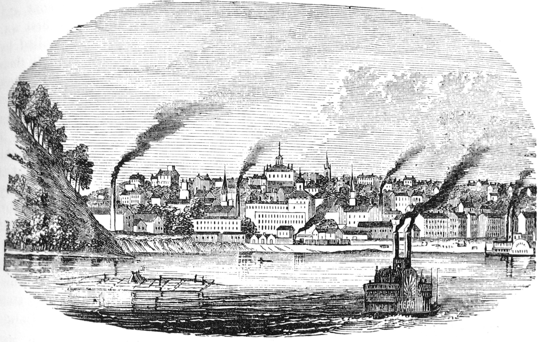
Burlington is a city in, and the county seat of, Des Moines County, Iowa, United States. The population was 23,982 in the 2020 census, a decline from the 26,839 population in 2000. Burlington is the center of a micropolitan area, which includes West Burlington and Middletown, Iowa, and Gulfport, Illinois. Burlington is the home of Snake Alley, the most crooked street. History Prior to European settlement, the area was neutral territory for the Sac and Fox Native American tribes, who called it Shoquoquon (''Shok-ko-kon''), meaning Flint Hills. In 1803, President Thomas Jefferson organized two parties of explorers to map the Louisiana Purchase. The Lewis and Clark Expedition followed the Missouri River, while Lt. Zebulon Pike followed the Mississippi River. In 1805, Pike landed at the bluffs below Burlington and raised the United States Flag for the first time on what would become Iowa soil and recommended construction of a fort. The recommendation went unheeded. The Am ... [...More Info...] [...Related Items...] OR: [Wikipedia] [Google] [Baidu] |
West Des Moines, Iowa
West Des Moines is a city in Polk County, Iowa, Polk, Dallas County, Iowa, Dallas, Warren County, Iowa, Warren, and Madison County, Iowa, Madison counties in the U.S. state of Iowa. A majority of the city is located in Polk County, a minority of the city is located in Dallas County, and small portions extend into Warren and Madison counties. As of the 2020 United States Census, 2020 census, the city population was 68,723. West Des Moines is the second-largest city in the Des Moines metropolitan area and the sixth-largest city in Iowa. It ranked 94th in ''Money (magazine), Money'' magazine's list of the "100 Best Places to Live and Launch" in 2008, 77th and 57th on the 100 Best Places to Live in 2014 and 2015, respectively, and 18th on the Hipster (contemporary subculture), Hipster Cities of 2015. History Settlement and early history The West Des Moines area used to be home to the Sauk people, Sac and Meskwaki, Fox tribes. Near the stroke of midnight on October 11, 1845, a gunsh ... [...More Info...] [...Related Items...] OR: [Wikipedia] [Google] [Baidu] |


