|
List Of Airports In Zambia
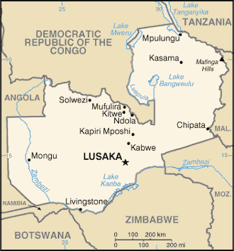
This is a list of airports in Zambia, sorted by location. Zambia, officially the Republic of Zambia, is a landlocked country in Southern Africa. The neighboring countries are the Democratic Republic of the Congo to the north, Tanzania to the northeast, Malawi to the east, Mozambique, Zimbabwe, Botswana and Namibia to the south, and Angola to the west. Zambia is divided into ten provinces. The capital city is Lusaka. __NOTOC__ Airports Airport names shown in bold indicate the airport has scheduled service on commercial airlines. See also * Department of Civil Aviation of Zambia * Transport in Zambia * List of Zambian airports by ICAO code * Wikipedia: WikiProject Aviation/Airline destination lists: Africa#Zambia References * * - includes IATA codes Great Circle Mapper: Airports in Zambia- IATA and ICAO codes {{Africa in topic, List of airports in, state=collapsed Zambia Airports Airports Zambia Zambia (), officially the Republic of Zambia, is a ... [...More Info...] [...Related Items...] OR: [Wikipedia] [Google] [Baidu] |
List Of Cities And Towns In Zambia
This is a list of cities, towns, villages and missions in Zambia. Cities Towns, villages and missions *Chadiza * Chama * Chandesi * Chavuma *Chembe * Chibombo * Chiengi * Chilubi *Chililabombwe * Chinsali * Chinyingi * Chirundu * Chisamba * Choma *Gwembe * Isoka *Kabompo *Kafue * Kafulwe *Kalabo *Kalene Hill * Kalomo *Kalulushi *Kanyembo *Kaoma *Kapiri Mposhi *Kasempa * Kashikishi * Kataba *Katete *Kawambwa *Kazembe (Mwansabombwe) *Kazungula * Kibombomene * Luangwa * Lufwanyama *Lukulu *Lundazi * Macha Mission *Makeni *Mansa *Mazabuka * Mbala *Mbereshi *Mfuwe * Milenge *Misisi *Mkushi *Mongu * Monze *Mpika *Mporokoso * Mpulungu *Mumbwa * Muyombe *Mwinilunga * Nchelenge * Ngoma *Nkana * Nseluka *Pemba *Petauke *Samfya *Senanga *Serenje *Sesheke * Shiwa Ngandu *Siavonga * Sikalongo * Sinazongwe *Solwezi *Venture *Zambezi * Zimba See also *Districts of Zambia *Provinces of Zambia *List of cities by country * List of Zambia-related topics * List of cities in East Africa Referen ... [...More Info...] [...Related Items...] OR: [Wikipedia] [Google] [Baidu] |
Kalabo
Kalabo is an urban centre in Kalabo District, in the Western Province of Zambia. The town is the headquarters of the district with the same name. Location The town is located on the plains west of the Zambezi River and the Barotse Floodplain, and approximately , by road east of the town of Sikongo, Zambia, close to the border with Angola. This is approximately , by road, west of Lusaka, Zambia's capital and largest city. The geographical coordinates of Kalabo are:14°59'28.0"S, 22°40'44.0"E (Latitude:-14.991111; Longitude:22.678889). Kalabo sits at an average elevation of above mean sea level. Overview It is situated on the bank of the Luanginga River across which a small pontoon ferry connects to a dirt track going north-west to the Angolan border. Kalabo is the base for the Liuwa Plain National Park which can be reached by off-road vehicles about , north of the pontoon. Zambia's Western Province was formerly known as Barotseland, and Liuwa Plain was the Barotse king's hunti ... [...More Info...] [...Related Items...] OR: [Wikipedia] [Google] [Baidu] |
Milliken Airport
Milliken Airport is an airport serving Kabwe, a city in the Central Province of Zambia. The airport is on the west side of the city. See also * * *Transport in Zambia *List of airports in Zambia This is a list of airports in Zambia, sorted by location. Zambia, officially the Republic of Zambia, is a landlocked country in Southern Africa. The neighboring countries are the Democratic Republic of the Congo to the north, Tanzania to the nor ... References External linksOpenStreetMap - Milliken Airport * * Google Earth Airports in Zambia Kabwe [...More Info...] [...Related Items...] OR: [Wikipedia] [Google] [Baidu] |
Central Province, Zambia
Central Province is one of Zambia's ten provinces. The provincial capital is Kabwe, which is the home of the Mulungushi Rock of Authority. Central Province has an area of . It borders eight other provinces and has eleven districts. The total area of forest in the province is , and it has a national park and three game management areas. The first mine in the region was opened up in 1905 making the then Broken Hill town the first mining town. In 1966, he town's name was reverted to its indigenous name - Kabwe (Kabwe-Ka Mukuba) meaning 'ore' or 'smelting'. As of 2010, Central Province had a population of 1,307,111, comprising 10.05% of the total Zambian population. The literacy rate stood at 70.90% against a national average of 70.2%. Census 2012, p. 24 Bemba was the most spoken language with 31.80% speaking it, and Lala was the majority clan in the province, comprising 20.3% of population. Central Province contains 20.64% of the total area of cultivated land in Zambia and contr ... [...More Info...] [...Related Items...] OR: [Wikipedia] [Google] [Baidu] |
Kabwe
Kabwe is the capital of the Zambian Central Province and the Kabwe District, with a population estimated at 202,914 at the 2010 census. Named Broken Hill until 1966, it was founded when lead and zinc deposits were discovered in 1902. Kabwe also has a claim to being the birthplace of Zambian politics as it was an important political centre during the colonial period. Kabwe is an important transportation, farming and university centre. Kabwe is becoming a major agricultural hub for the country is the headquarters for Zambia Railways and prison services. Additionally the mining industry has been important to the economic development of the region. However, because of the exceptional contamination of the city with lead and other toxins, and the effects of these on local children's health, a March 2022 report by the UN Special Rapporteur on Human Rights and the Environment identified the town as a sacrifice zone for industry. History Headquarters of Zambia Railways The first ra ... [...More Info...] [...Related Items...] OR: [Wikipedia] [Google] [Baidu] |
Chipata Airport
Chipata Airport is an airport serving Chipata, a city in the Eastern Province of Zambia. The Chipata non-directional beacon (Ident: CP) is located on the field. Location Chipata Airport is in eastern Zambia, near the town of Chipata, approximately , by air, northeast of Lusaka International Airport, the country's largest civilian and military airport. This location is approximately by road, northwest of the central business district of the town of Chipata. Airlines and destinations See also *Transport in Zambia *List of airports in Zambia This is a list of airports in Zambia, sorted by location. Zambia, officially the Republic of Zambia, is a landlocked country in Southern Africa. The neighboring countries are the Democratic Republic of the Congo to the north, Tanzania to the nor ... References External links *OpenStreetMap - Chipata Airport Airports in Zambia Buildings and structures in Eastern Province, Zambia {{Zambia-airport-stub ... [...More Info...] [...Related Items...] OR: [Wikipedia] [Google] [Baidu] |
Eastern Province, Zambia
Eastern Province is one of Zambia's ten provinces. The province lies between the Luangwa River and borders with Malawi to the east and Mozambique to the south, from Isoka in the northeast to the north of Luangwa in the south. The provincial capital is Chipata. Eastern province has an area of , locally shares border with three other provinces of the country and is divided into fifteen districts. As per the 2010 Zambian census, Eastern Province had a population of 1,592,661, accounting to 12.16% of the total Zambian population. The sex ratio was 1,030 for every 1,000 males. As of 2010, Chewa was the largest community in the region with 39.7 per cent of the total population and Chewa was the most widely spoken language with 34.6 per cent speaking it. On the tourism front, the province has four national parks. The province has two significant traditional ceremonies being the Nc'wala festival celebrated in Chipata District by the Ngoni tribe during February and the Chewa Kulamb ... [...More Info...] [...Related Items...] OR: [Wikipedia] [Google] [Baidu] |
Chipata
The city of Chipata is the administrative centre of the Eastern Province of Zambia and Chipata District. It was declared the 5th city of the country, after Lusaka, Ndola, Kitwe and Livingstone, by President Edgar Lungu on 24 February 2017. The city has undergone rapid economic and infrastructure growth in the years, leading up to city status. Location Chipata is located approximately , east of Lusaka, the capital city of Zambia. This is about west of Lilongwe, the capital city of Malawi. The geographical coordinates of Chipata are 13°38'43.0"S, 32°38'47.0"E (Latitude:13°38'43.0"S; Longitude:32°38'47.0"E). The average elevation of Chipata is , above sea level. Overview Having a modern market, a central hospital, shopping malls, a university, some colleges and a number of schools, Chipata is the business and administrative hub of the region. The town boasts a four star hotel, a golf course, an airport, and a "welcome arch". Developed areas includes Kalongwezi, Moth, and Lit ... [...More Info...] [...Related Items...] OR: [Wikipedia] [Google] [Baidu] |
Kasompe Airport
Kasompe Airport is an airport serving Chingola, a city in the Copperbelt Province in Zambia. The airport is in the suburb of Kasompe, southeast of Chingola. The Kasompe non-directional beacon (ident: KE) is approximately west of the Rwy 11 threshold. See also *Transport in Zambia *List of airports in Zambia This is a list of airports in Zambia, sorted by location. Zambia, officially the Republic of Zambia, is a landlocked country in Southern Africa. The neighboring countries are the Democratic Republic of the Congo to the north, Tanzania to the nor ... References External linksOpenStreetMap - Chingola * Airports in Zambia [...More Info...] [...Related Items...] OR: [Wikipedia] [Google] [Baidu] |
Copperbelt Province
Copperbelt Province is a province in Zambia which covers the mineral-rich Copperbelt, and farming and bush areas to the south. It was the backbone of the Northern Rhodesian economy during British colonial rule and fuelled the hopes of the immediate post-independence period, but its economic importance was severely damaged by a crash in global copper prices in 1973. The province adjoins the Haut-Katanga province of the Democratic Republic of the Congo, which is similarly mineral-rich. The main cities of the Copperbelt are Kitwe, Ndola, Mufulira, Luanshya, Chingola, Kalulushi and Chililabombwe. Roads and rail links extend north into the Congo to Lubumbashi, but the Second Congo War brought economic contact between the two countries to a standstill, now recovering. It is informally referred to at times as 'Copala' or 'Kopala', invoking the vernacular-like term of the mineral copper that is mined in the province. Demographics As per the 2010 Zambian census, Copperbelt Provinc ... [...More Info...] [...Related Items...] OR: [Wikipedia] [Google] [Baidu] |
Chingola
Chingola is a city in Zambia's Copperbelt Province, the country's copper-mining region, with a population of 216,626 (2010 census). It is the home of Nchanga Copper Mine, a deep-shaft high-grade content copper mining operation, which subsequently (in the 1960s) led to the development of two open pit operations, Chingola Open Pit and then Nchanga Open Pit (the latter being the second largest open cast mine in the world). History Chingola was founded in 1943, somewhat later than most other Copperbelt towns. Chingola was built to service the newly opened Nchanga copper mine. Alongside Luanshya (the "Garden Town of the Copperbelt"), Chingola is perhaps one of the best laid-out and most picturesque towns in Zambia. Mines Situated at the north-west end of the Copperbelt Province, the Nchanga Mines Open Pit workings lie in an arc 11 km long around the west and north of the town, covering nearly 30 km2. The deepest part of the pit is 400 m lower than the surrounding plateau ... [...More Info...] [...Related Items...] OR: [Wikipedia] [Google] [Baidu] |


