|
Liefdefjorden
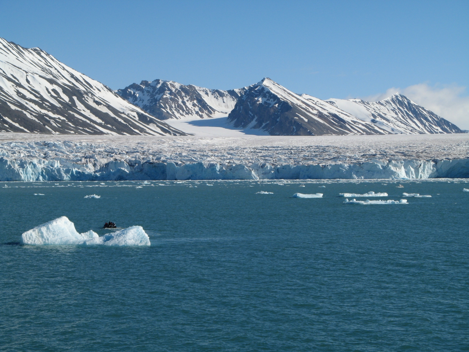
Liefdefjorden ( en, The Love Fjord) is a fjord in Haakon VII Land on Spitsbergen, Svalbard. It has a length of about . Former names of the fjord include ''Baye d'Amour'', ''Kjærlighedsbugten'', ''Porto detto l'Amato'', ''Liefde Bay'' and ''Love Bay''. Monacobreen debouches into the fjord. At the northern side of the outer part of the fjord is the peninsula Reinsdyrflya. ''Liefde'' is Dutch Dutch commonly refers to: * Something of, from, or related to the Netherlands * Dutch people () * Dutch language () Dutch may also refer to: Places * Dutch, West Virginia, a community in the United States * Pennsylvania Dutch Country People E ... for "love" and the fjord is possible named after a ship "de Liefde". at http://placenames.npolar.no References [...More Info...] [...Related Items...] OR: [Wikipedia] [Google] [Baidu] |
Monacobreen
Monacobreen is a glacier in Haakon VII Land on Spitsbergen, Svalbard. The glacier debouches into Liefdefjorden Liefdefjorden ( en, The Love Fjord) is a fjord in Haakon VII Land on Spitsbergen, Svalbard. It has a length of about . Former names of the fjord include ''Baye d'Amour'', ''Kjærlighedsbugten'', ''Porto detto l'Amato'', ''Liefde Bay'' and ''Love Bay .... Former names of the glacier include ''Glacier de Monaco'' and ''Liefde Bay-bræ''. References Glaciers of Spitsbergen {{spitsbergen-glacier-stub ... [...More Info...] [...Related Items...] OR: [Wikipedia] [Google] [Baidu] |
Reinsdyrflya
Reinsdyrflya (Reindeer peninsula) is a peninsula in Haakon VII Land at Spitsbergen, Svalbard, Norway. It defines the western side of the outer part of Woodfjorden, and the northern side of the outer part of Liefdefjorden. References Peninsulas of Spitsbergen {{Spitsbergen-geo-stub ... [...More Info...] [...Related Items...] OR: [Wikipedia] [Google] [Baidu] |
Fjord
In physical geography, a fjord or fiord () is a long, narrow inlet with steep sides or cliffs, created by a glacier. Fjords exist on the coasts of Alaska, Antarctica, British Columbia, Chile, Denmark, Germany, Greenland, the Faroe Islands, Iceland, Ireland, Kamchatka, the Kerguelen Islands, Labrador, Newfoundland, New Zealand, Norway, Novaya Zemlya, Nunavut, Quebec, the Patagonia region of Argentina and Chile, Russia, South Georgia Island, Tasmania, United Kingdom, and Washington state. Norway's coastline is estimated to be long with its nearly 1,200 fjords, but only long excluding the fjords. Formation A true fjord is formed when a glacier cuts a U-shaped valley by ice segregation and abrasion of the surrounding bedrock. According to the standard model, glaciers formed in pre-glacial valleys with a gently sloping valley floor. The work of the glacier then left an overdeepened U-shaped valley that ends abruptly at a valley or trough end. Such valleys are fjords wh ... [...More Info...] [...Related Items...] OR: [Wikipedia] [Google] [Baidu] |
Haakon VII Land
Haakon VII Land is a land area at the northwestern part of Spitsbergen, Svalbard, between Woodfjorden and Kongsfjorden Kongsfjorden as seen from Blomstrandhalvøya Kongsfjorden (Kongs Fjord or Kings Bay) is an inlet on the west coast of Spitsbergen, an island which is part of the Svalbard archipelago in the Arctic Ocean. The inlet is long and ranges in width .... The area is named after Haakon VII of Norway. The highest mountain in Haakon VII Land is Eidsvollfjellet. References Geography of Svalbard Spitsbergen {{Spitsbergen-geo-stub ... [...More Info...] [...Related Items...] OR: [Wikipedia] [Google] [Baidu] |
Spitsbergen
Spitsbergen (; formerly known as West Spitsbergen; Norwegian: ''Vest Spitsbergen'' or ''Vestspitsbergen'' , also sometimes spelled Spitzbergen) is the largest and the only permanently populated island of the Svalbard archipelago in northern Norway. Constituting the westernmost bulk of the archipelago, it borders the Arctic Ocean, the Norwegian Sea, and the Greenland Sea. Spitsbergen covers an area of , making it the largest island in Norway and the 36th-largest in the world. The administrative centre is Longyearbyen. Other settlements, in addition to research outposts, are the Russian mining community of Barentsburg, the research community of Ny-Ålesund, and the mining outpost of Sveagruva. Spitsbergen was covered in of ice in 1999, which was approximately 58.5% of the island's total area. The island was first used as a whaling base in the 17th and 18th centuries, after which it was abandoned. Coal mining started at the end of the 19th century, and several permanent commun ... [...More Info...] [...Related Items...] OR: [Wikipedia] [Google] [Baidu] |
Svalbard
Svalbard ( , ), also known as Spitsbergen, or Spitzbergen, is a Norwegian archipelago in the Arctic Ocean. North of mainland Europe, it is about midway between the northern coast of Norway and the North Pole. The islands of the group range from 74° to 81° north latitude, and from 10° to 35° east longitude. The largest island is Spitsbergen, followed by Nordaustlandet and . The largest settlement is Longyearbyen. The islands were first used as a base by the whalers who sailed far north in the 17th and 18th centuries, after which they were abandoned. Coal mining started at the beginning of the 20th century, and several permanent communities were established. The Svalbard Treaty of 1920 recognizes Norwegian sovereignty, and the 1925 Svalbard Act made Svalbard a full part of the Kingdom of Norway. They also established Svalbard as a free economic zone and a demilitarized zone. The Norwegian Store Norske and the Russian remain the only mining companies in place. Res ... [...More Info...] [...Related Items...] OR: [Wikipedia] [Google] [Baidu] |
Debouch
In hydrology, a debouch (or debouche) is a place where runoff from a small, confined space discharges into a larger, broader body of water. The word is derived from the French verb ''déboucher'' (), which means "to unblock, to clear". The term also has a military usage. Geology In fluvial geomorphology, a debouch is a place where runoff from a small, confined space emerges into a larger, broader space. Common examples are when a stream runs into a river or when a river runs into an ocean. Debouching can generate massive amounts of sediment transport. When a narrow stream travels down a mountain pass into a basin, an alluvial fan will form from the mass deposit of the sediment. The four largest rivers (the Amazon, the Ganges-Brahmaputra, the Yangtze and the Yellow) are responsible for 20% of the global discharge of sediment in to the oceans by debouches. Geography In fluvial geography, a debouch is a place where a body of water pours forth from a narrow opening. Some examples ar ... [...More Info...] [...Related Items...] OR: [Wikipedia] [Google] [Baidu] |
Norwegian Polar Institute
The Norwegian Polar Institute (NPI; no, Norsk Polarinstitutt) is Norway's central governmental institution for scientific research, mapping and environmental monitoring in the Arctic and the Antarctic. The NPI is a directorate under Norway's Ministry of Climate and Environment. The institute advises Norwegian authorities on matters concerning polar environmental management and is the official environmental management body for Norwegian activities in Antarctica. Activities The institute's activities are focused on environmental research and management in the polar regions. The NPI's researchers investigate biodiversity, climate and environmental toxins in the Arctic and Antarctic, and in this context the institute equips and organizes large-scale expeditions to both polar regions. The institute contributes to national and international climate work, and is an active contact point for the international scientific community. The institute collects and analyses data on the environm ... [...More Info...] [...Related Items...] OR: [Wikipedia] [Google] [Baidu] |
Store Norske Leksikon
The ''Great Norwegian Encyclopedia'' ( no, Store Norske Leksikon, abbreviated ''SNL''), is a Norwegian-language online encyclopedia. The online encyclopedia is among the most-read Norwegian published sites, with more than two million unique visitors per month. Paper editions 1978–2007 The ''SNL'' was created in 1978, when the two publishing houses Aschehoug and Gyldendal merged their encyclopedias and created the company Kunnskapsforlaget. Up until 1978 the two publishing houses of Aschehoug and Gyldendal, Norway's two largest, had published ' and ', respectively. The respective first editions were published in 1907–1913 (Aschehoug) and 1933–1934 (Gyldendal). The slump in sales for paper-based encyclopedias around the turn of the 21st century hit Kunnskapsforlaget hard, but a fourth edition of the paper encyclopedia was secured by a grant of ten million Norwegian kroner from the foundation Fritt Ord in 2003. The fourth edition consisted of 16 volumes, a t ... [...More Info...] [...Related Items...] OR: [Wikipedia] [Google] [Baidu] |
Dutch Language
Dutch ( ) is a West Germanic language spoken by about 25 million people as a first language and 5 million as a second language. It is the third most widely spoken Germanic language, after its close relatives German and English. ''Afrikaans'' is a separate but somewhat mutually intelligible daughter languageAfrikaans is a daughter language of Dutch; see , , , , , . Afrikaans was historically called Cape Dutch; see , , , , , . Afrikaans is rooted in 17th-century dialects of Dutch; see , , , . Afrikaans is variously described as a creole, a partially creolised language, or a deviant variety of Dutch; see . spoken, to some degree, by at least 16 million people, mainly in South Africa and Namibia, evolving from the Cape Dutch dialects of Southern Africa. The dialects used in Belgium (including Flemish) and in Suriname, meanwhile, are all guided by the Dutch Language Union. In Europe, most of the population of the Netherlands (where it is the only official language spoken country ... [...More Info...] [...Related Items...] OR: [Wikipedia] [Google] [Baidu] |

.jpg)


