|
Lichte (Thuringia) Station
The Lichte (Thuringia) station german: Bahnhof Lichte (Thüringen) was a Deutsche Reichsbahn station in the Thuringian municipality of Lichte in the district of Saalfeld-Rudolstadt. The station is elevated 623 m above Sea Level. History The Probstzella–Schmiedefeld line opened at the end of 1898, and it was extended to Lichte-Ost in 1899. At this time that final destination was called "Bock Wallendorrf". But only 10 years later, in 1909, the project to extend the line to Lichte (Thüringen), Ernstthal (with junction to Neuhaus am Rennweg), and further to Lauscha was started. Finally, in 1913 the railway construction was completed and the train service from the Probstzella station to Sonnenberg via Lichte-Ost and Lichte (Thüringen) could be opened. The railway Sonneberg-Probstzelle survived two World Wars and the GDR period. However, on 22 January 1997, traffic ceased, and in July 2006 the final closure of that particular railway section Ernstthal Gräfenthal was agreed ... [...More Info...] [...Related Items...] OR: [Wikipedia] [Google] [Baidu] |
Lichte
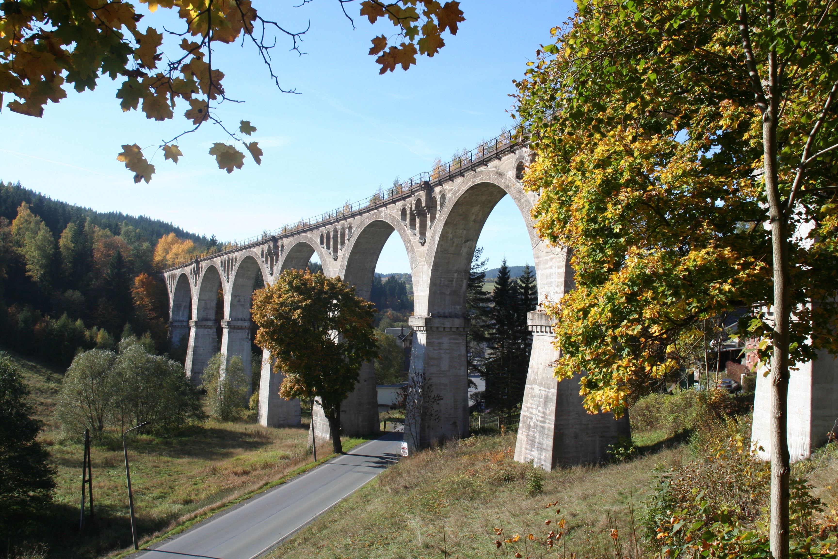
220px, Wallendorfer Porcelain Manufacture, Oct. 2006 220px, Leibis-Lichte Dam, 102.5 m high Lichte is a village and a former municipality in the district of Sonneberg in Thuringia, Germany, close to the Thuringian Rennsteig. Formerly in the district Saalfeld-Rudolstadt, it is part of the town Neuhaus am Rennweg since January 2019. Geography Lichte is located between the towns of Saalfeld (to the north), Oberhof / Ilmenau (northwest) and Sonneberg / Coburg (south) at an altitude of 600 m (NHN), in the centre of the Thuringian Highlands / Thuringian Forest Nature Park. Distinctive sign of Lichte is the railway viaduct established in 1909 (see picture right). It is a typical Thuringian Forest village, reaching far into the valleys of the Lichte River and of its tributary the Piesau. Both of these feed one of the biggest Thuringian drinking water reservoirs, Leibis-Lichte, with the Deesbach Forebay close to the northern end of the village (in Geiersthal). The Lichte Ri ... [...More Info...] [...Related Items...] OR: [Wikipedia] [Google] [Baidu] |
Gräfenthal
Gräfenthal () is a town in the district of Saalfeld-Rudolstadt in Thuringia, Germany. Geography Gräfenthal is located in the southern Thüringer Schiefergebirge, a low mountain range south-eastern of the better known Thuringian Forest. Mountains in this region rise up to 800 meters above sea level and are usually wooded with spruce trees. 20 km north-eastern of Gräfenthal lies district town Saalfeld. Neighboring municipalities (clockwise, starting northwards) are: Reichmannsdorf, Probstzella, Ludwigsstadt, Tettau, Oberland am Rennsteig, Piesau, Lichte, Schmiedefeld Gräfenthal has 8 subdivisions: *Buchbach *Creunitz *Gebersdorf *Gräfenthal *Großneundorf *Lichtenhain *Lippelsdorf *Sommersdorf History In 1288 the town was first mentioned. It was for much of its early history under various Ernestine princelings. Number of inhabitants * 1994: 3.146 * 1997: 3.036 * 2000: 2.913 * 2003: 2.808 * 2006: 2.692 * 2009: 2.499 * 2012: 2.150 * 2014: 2.056 Pictures ... [...More Info...] [...Related Items...] OR: [Wikipedia] [Google] [Baidu] |
Buildings And Structures In Saalfeld-Rudolstadt
A building, or edifice, is an enclosed structure with a roof and walls standing more or less permanently in one place, such as a house or factory (although there's also portable buildings). Buildings come in a variety of sizes, shapes, and functions, and have been adapted throughout history for a wide number of factors, from building materials available, to weather conditions, land prices, ground conditions, specific uses, prestige, and aesthetic reasons. To better understand the term ''building'' compare the list of nonbuilding structures. Buildings serve several societal needs – primarily as shelter from weather, security, living space, privacy, to store belongings, and to comfortably live and work. A building as a shelter represents a physical division of the human habitat (a place of comfort and safety) and the ''outside'' (a place that at times may be harsh and harmful). Ever since the first cave paintings, buildings have also become objects or canvasses of much artis ... [...More Info...] [...Related Items...] OR: [Wikipedia] [Google] [Baidu] |
Railway Stations In Thuringia
Rail transport (also known as train transport) is a means of transport that transfers passengers and goods on wheeled vehicles running on rails, which are incorporated in Track (rail transport), tracks. In contrast to road transport, where the vehicles run on a prepared flat surface, rail vehicles (rolling stock) are directionally guided by the tracks on which they run. Tracks usually consist of steel rails, installed on Railroad tie, sleepers (ties) set in track ballast, ballast, on which the rolling stock, usually fitted with metal wheels, moves. Other variations are also possible, such as "slab track", in which the rails are fastened to a concrete foundation resting on a prepared subsurface. Rolling stock in a rail transport system generally encounters lower friction, frictional resistance than rubber-tyred road vehicles, so passenger and freight cars (carriages and wagons) can be coupled into longer trains. The rail transport operations, operation is carried out by a ... [...More Info...] [...Related Items...] OR: [Wikipedia] [Google] [Baidu] |
Viaduct
A viaduct is a specific type of bridge that consists of a series of arches, piers or columns supporting a long elevated railway or road. Typically a viaduct connects two points of roughly equal elevation, allowing direct overpass across a wide valley, road, river, or other low-lying terrain features and obstacles. The term ''viaduct'' is derived from the Latin ''via'' meaning "road", and ''ducere'' meaning "to lead". It is a 19th-century derivation from an analogy with ancient Roman aqueducts. Like the Roman aqueducts, many early viaducts comprised a series of arches of roughly equal length. Over land The longest in antiquity may have been the Pont Serme which crossed wide marshes in southern France. At its longest point, it measured 2,679 meters with a width of 22 meters. Viaducts are commonly used in many cities that are railroad hubs, such as Chicago, Birmingham, London and Manchester. These viaducts cross the large railroad yards that are needed for freight trains there, ... [...More Info...] [...Related Items...] OR: [Wikipedia] [Google] [Baidu] |
Lichte (Thuringia) East Station
The Lichte (Thuringia) east station (german: Bahnhof Lichte (Thüringen) Ost) was a Deutsche Reichsbahn station of the Thuringian municipality of Lichte (Wallendorf) in the district of Saalfeld-Rudolstadt. This now-defunct station is located on an altitude of 618.54 m above NN. There are two platforms, three transit tracks, one street connection, one cargo street, one deposit track, and one track to the goods shed. Lichte (Thuringia) east station was also an express train station ({{Lang-de, Eilzugstation) on the railway line from Sonneberg to Probstzella. History This train station was opened in January, 16th 1899. The first name was ''Bock-Wallendorf''. It was the new final destination of the railway line from Probstzella to Schmiedefeld (Lichtetal). Only much later, in October, 31st 1913 this terminal station was enhanced to an ''express railway station'', as the railway line from Probstzella was extended to Lauscha, and Sonneberg. However, with the reduction of goods ... [...More Info...] [...Related Items...] OR: [Wikipedia] [Google] [Baidu] |
Draisine
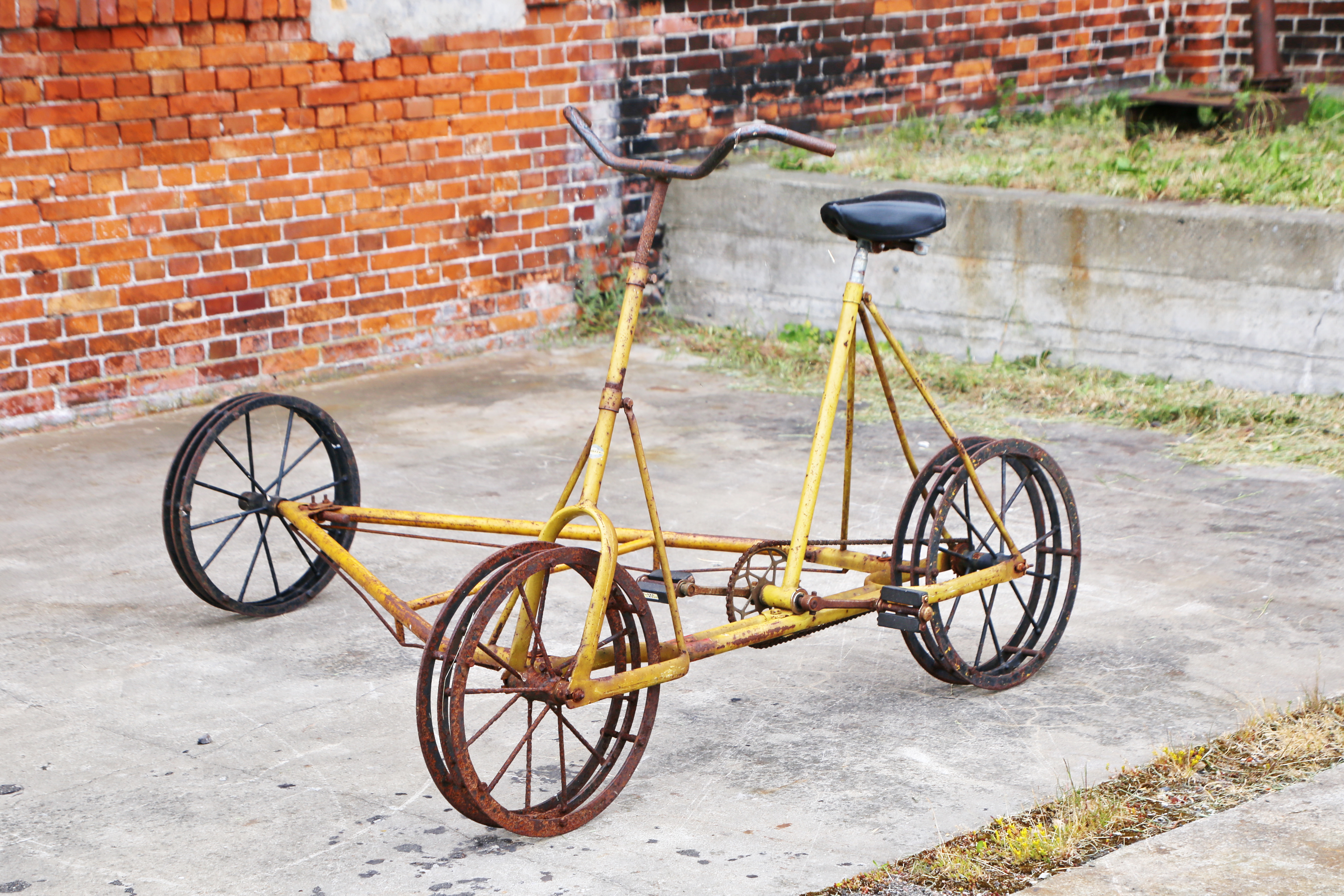
A draisine () is a light auxiliary rail vehicle, driven by service personnel, equipped to transport crew and material necessary for the maintenance of railway infrastructure. The eponymous term is derived from the German inventor Baron Karl Drais, who invented his ''Laufmaschine'' (German for "running machine") in 1817, which was called ''Draisine'' in German (''vélocipède'' or ''draisienne'' in French) by the press. It is the first reliable claim for a practically used precursor to the bicycle, basically the first commercially successful two-wheeled, steerable, human-propelled machine, nicknamed hobby-horse or dandy horse. Later, the name draisine came to be applied only to the invention used on rails and was extended to similar vehicles, even when not human-powered. Because of their low weight and small size, they can be put on and taken off the rails at any place, allowing trains to pass. In the United States, motor-powered draisines are known as speeders while human- ... [...More Info...] [...Related Items...] OR: [Wikipedia] [Google] [Baidu] |
Eisenbahnbundesamt
The German Federal Railway Authority (german: Eisenbahn-Bundesamt, ) has been the independent federal authority for the regulation of the railways in Germany since 1 January 1994. It is under the supervision and direction of the Federal Ministry for Digital and Transport and is headed by a president. Responsibilities The EBA is the inspectorate and authorising body for the majority of German domestic, railway infrastructure companies that are owned by the government, referred to as federal railways (''Eisenbahnen des Bundes'' or ''EdB''), and for German and foreign railway transport operators in Germany. Non federally owned public railways and privately operated railways are under the supervision of the German states ('' Bundesländer''), who can choose to transfer this responsibility to the EBA (§ 5 Abs. 2 AEG). To date 11 states, with the exception of Berlin, Bremen, Hamburg, Hesse and Lower Saxony have chosen to do so. In such cases the EBA work ... [...More Info...] [...Related Items...] OR: [Wikipedia] [Google] [Baidu] |
Sonneberg Hauptbahnhof
Sonneberg in Thuringia, Germany, is the seat of the Sonneberg district. It is in the Franconian south of Thuringia, neighboring its Upper Franconian twin town Neustadt bei Coburg. Sonneberg became known as the "world toy city", and is home to the and the Sonneberg observatory, founded in 1925. The Thuringian Slate Mountains border the city, with the Franconian Forest to the east. History "The Sonneberg Castle was also called Sonneberg Castle or the Haus zu Sonneberg in old documents. In 480 Süne or Süno, Duke of Franconia, built this castle because of the Thuringian incursions ..." so it says on page 64 in the topography of the Duke of Saxe-Meiningen's share in the Duchy of Coburg from the year 1781. This not uncritical representation is based on the history of the Franks by Abbot Johannes Trithemius from 1514. The name Sonneberg was first mentioned in documents in 1207. It goes back to the noble family of the Lords of Sonneberg, which is documented in the 12th and 13th c ... [...More Info...] [...Related Items...] OR: [Wikipedia] [Google] [Baidu] |
Probstzella Station
Probstzella station is the station of the Thuringian town of Probstzella in the district of Saalfeld-Rudolstadt. It is located at the southeastern edge of Probstzella and since 1 October 1885 it has been a through station on the Franconian Forest Railway. The station is 1.3 km from the Bavarian-Thuringian border and after the Second World War until German reunification in 1990, it served as the point of entry for traffic passing from West Germany to East Germany and is considered the last remaining border station on the Inner German border. History The station was opened on 8 August 1885 with the completion of the section of the Franconian Forest Railway from Eichicht (now part of Kaulsdorf) to Probstzella as one of the Prussian state railways. On 1 October 1885 the Royal Bavarian State Railways opened the Ludwigsstadt–Probstzella section, completing the line from Bavaria, following the earlier opening of the Stockheim–Ludwigsstadt section. Probstzella is the souther ... [...More Info...] [...Related Items...] OR: [Wikipedia] [Google] [Baidu] |
Lauscha
Lauscha is a town in the district of Sonneberg, in Thuringia, Germany. It is situated 13 km north of Sonneberg, and 24 km southwest of Saalfeld. Lauscha is known for its glassblowing, especially for Christmas tree decorations like baubles. Geography Lauscha is located in the mountain range of the Thüringer Schiefergebirge. The town is nestled into the steep valley of a tributary of the river Steinach just below the ridge of the mountain chain, the well-known Rennsteig. The main train station in Lauscha is 611 m above sealevel, the Pappenheimer Berg, the highest mountain within the town limits rises up to 834,5 m above sea level. Neighbouring towns Immediate neighbours are the following towns and villages: *Neuhaus am Rennweg *Lichte *Piesau *Oberland am Rennsteig * Steinach * Steinheid *Ernstthal am Rennsteig in the north east is part of Lauscha since 1994. Topography The town and valley of Lauscha get their name from the stream, which was first mentioned as 'l ... [...More Info...] [...Related Items...] OR: [Wikipedia] [Google] [Baidu] |


