|
Liberty City (Miami)
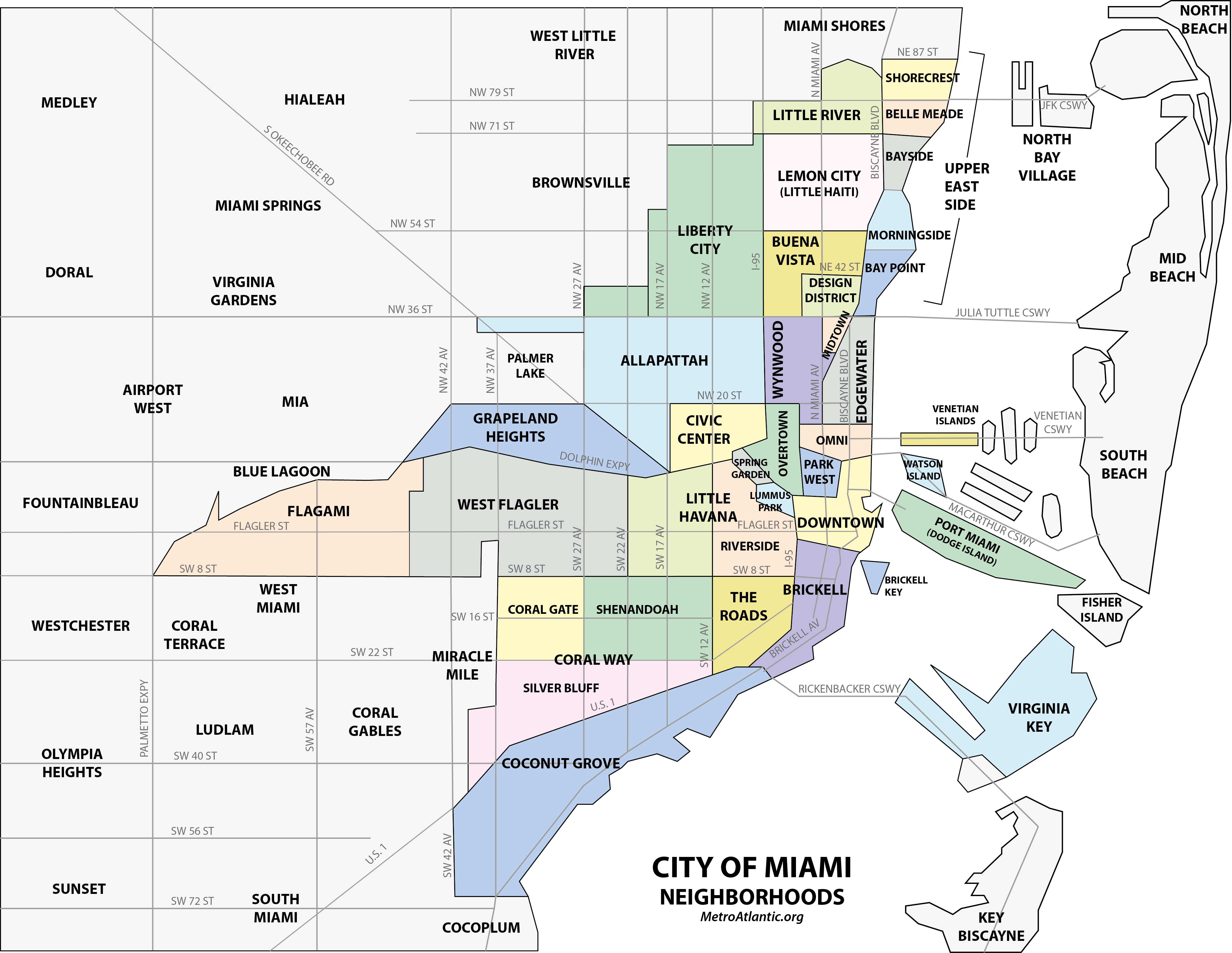
Liberty City is a neighborhood in Miami, Florida, United States. The area is roughly bound by NW 79th Street to the north, NW 27th Avenue to the west, the Airport Expressway to the South, and Interstate 95 to the east. The neighborhood is home to one of the largest concentrations of African Americans in South Florida, as of the 2000 census. Although it was often known as "Model City" both historically and by the City of Miami government, residents more commonly call it Liberty City. It is serviced by the Miami Metrorail at Dr. Martin Luther King Jr. Plaza and Brownsville stations along NW 27th Avenue. History Once part of the sparsely populated outskirts of northern Miami, what became Liberty City developed during the Great Depression of the 1930s when President Franklin D. Roosevelt authorized the construction of the Liberty Square housing project in 1933, the first of its kind in the Southern United States. Built as a response to the deteriorating housing conditio ... [...More Info...] [...Related Items...] OR: [Wikipedia] [Google] [Baidu] |
Neighborhoods In Miami
This is a list of neighborhoods in Miami in Miami-Dade County, Florida, United States. Many of the city's neighborhoods have been renamed, redefined and changed since the city's founding in 1896. As such, the exact extents of some neighborhoods can differ from person to person. The following is the list of all the city's major neighborhoods, including any corresponding sub-neighborhoods within them. Coconut Grove is an example of a neighborhood whose size and name has stayed relatively the same since its settlement in 1825. Having been settled originally as "Cocoanut Grove", its character has stayed almost intact from its early days.Planning Your Vacation in Florida, Miami and Dade County PA Guide to Miami Northport, NY: Bacon, Percy & Daggett, 1941, page 49. In contrast, other neighborhoods have undergone many name and size changes. Buena Vista was once a much larger neighborhood in the 1920s, than it is today. Buena Vista once consumed all of the Miami Design District as ... [...More Info...] [...Related Items...] OR: [Wikipedia] [Google] [Baidu] |
Florida State Road 934
State Road 934 (SR 934) runs for from State Road 826 (Palmetto Expressway) in Medley to SR A1A in Miami Beach. It is a major east–west highway in the Miami metropolitan area. State Road 934 is, for its longest span, Northwest 79th Street in Miami, but also traverses a variety of names as it crosses Hialeah Gardens, Hialeah, North Bay Village, and Miami Beach as Northeast 74th Street, the Hialeah Expressway and 21st Street in Hialeah, as the North 79th/81st Street one-way pair in Miami, the John F. Kennedy Causeway as it crosses Biscayne Bay, and as Normandy Drive and 71st Street in North Beach, Miami Beach (the last two forming a one-way pair in Miami Beach, respectively). Route description State Road 934 begins at the Palmetto Expressway in Medley. About two blocks east of the expressway, it crosses Milam Dairy Road/West 72nd Avenue, becoming the Hialeah Expressway, a limited access stretch of highway that extends to US 27 ( SR 25), and ends at Red Road (West 4th ... [...More Info...] [...Related Items...] OR: [Wikipedia] [Google] [Baidu] |
Brownsville, Florida
Brownsville (also known as Brown Sub) is an unincorporated community and census-designated place (CDP) in metropolitan Miami, Florida, United States. As of the 2010 census, the population was 16,583, up from 15,313 in 2010. After three decades of population loss, Brownsville gained population for the first time in over 40 years in the 2010 US Census. History Brownsville was originally a settlement for white families in the 1920s. Black families began moving into the neighborhood between the late 1940s and early 1960s as the population surrounding nearby Liberty Square expanded and many inner-city whites moved to newly built suburban subdivisions surrounding Miami city proper in the wake of World War II. In 1945, two black couples who lived in Brownsville were arrested and jailed for allegedly mishandling their garbage disposal. That same year, members of the Ku Klux Klan burned crosses in lawns and marched against black home ownership in the area. By the mid-1960s, Brownsv ... [...More Info...] [...Related Items...] OR: [Wikipedia] [Google] [Baidu] |
Overtown (Miami)
Overtown is a neighborhood of Miami, Florida, United States, just northwest of Downtown Miami. Originally called Colored Town in the Jim Crow era of the late 19th through the mid-20th century, the area was once the preeminent and is the historic center for commerce in the black community in Miami and South Florida. It is bound by NW 20th Street to the north, NW 5th Street to the south, the Miami River, Dolphin Expressway (SR 836), and I-95 (north of the Midtown Interchange) to the west, and the Florida East Coast Railway (FEC) and NW 1st Avenue to the east. Local residents often go by the demonym "Towners". History A part of the historic heart of Miami, it was designated as a "colored" neighborhood after the creation and incorporation of Miami in 1896. The incorporation of Miami as a city occurred at the insistence of Standard Oil and FEC railroad tycoon Henry Flagler, whose mostly black American railroad construction workers settled near what became Downtown Miami, just nort ... [...More Info...] [...Related Items...] OR: [Wikipedia] [Google] [Baidu] |
Restrictive Covenant
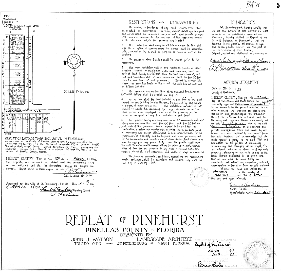
A covenant, in its most general sense and historical sense, is a solemn promise to engage in or refrain from a specified action. Under historical English common law, a covenant was distinguished from an ordinary contract by the presence of a seal. Because the presence of a seal indicated an unusual solemnity in the promises made in a covenant, the common law would enforce a covenant even in the absence of consideration. In United States contract law, an implied ''covenant'' of good faith is presumed. A covenant is an agreement like a contract. The covenantor makes a promise to a covenantee to perform an action ''(affirmative covenant'' in the United States or ''positive covenant'' in England and Wales) or to refrain from an action (negative covenant). In real property law, the term ''real covenants'' means that conditions are tied to the ownership or use of land. A "covenant running with the land", meeting tests of wording and circumstances laid down in precedent, imposes dut ... [...More Info...] [...Related Items...] OR: [Wikipedia] [Google] [Baidu] |
Liberty Square (Miami)
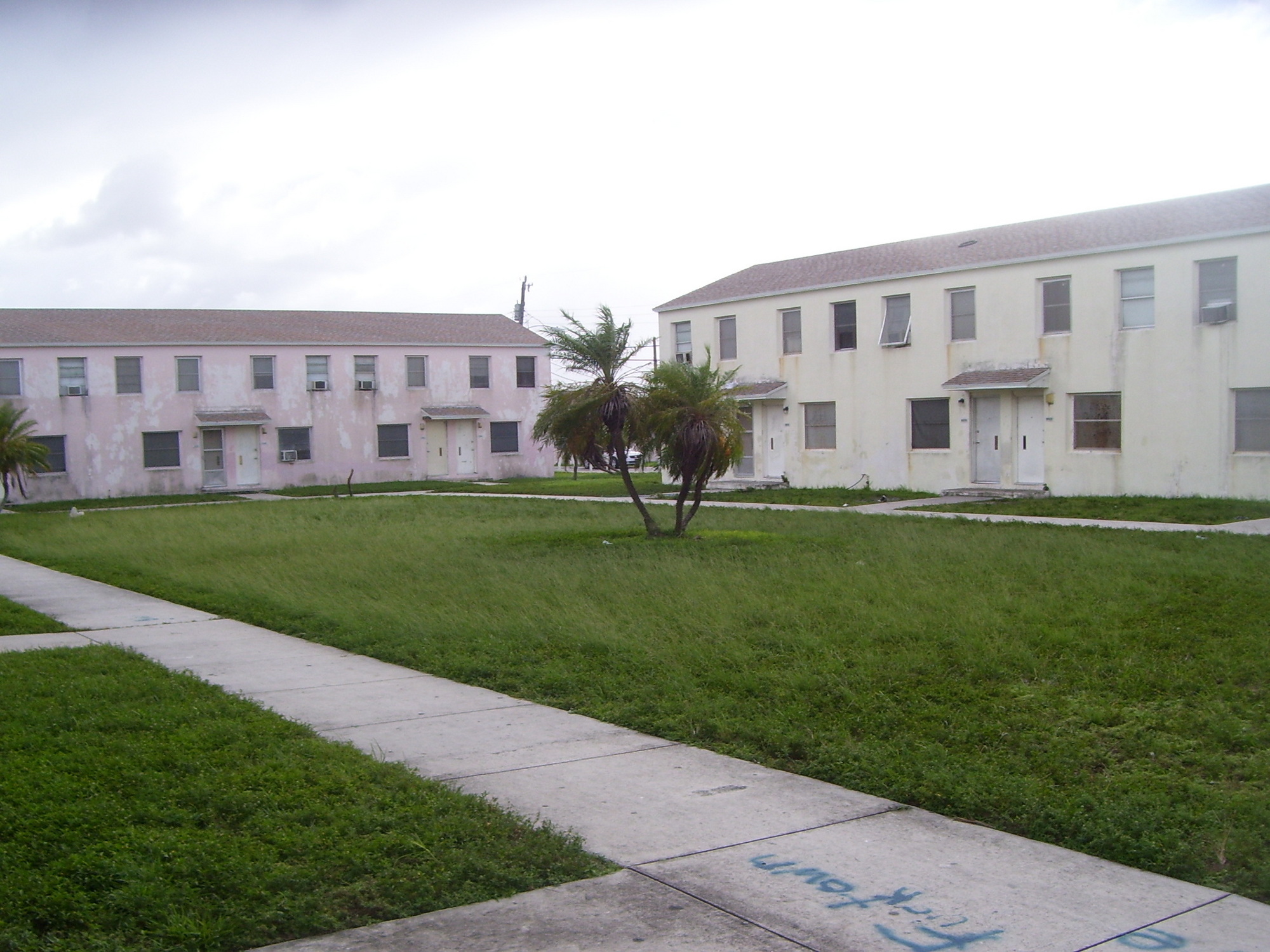
Liberty Square (often referred to as the Pork & Beans) is a 753-unit Miami-Dade public housing apartment complex in the Liberty City neighborhood of Miami, Florida. It is bordered at Martin Luther King Jr. Boulevard/North 62nd Street to the south, North 67th Street to the north, State Road 933 (Northwest 12th Avenue) to the east, and Northwest 15th Avenue to the west. Constructed as a part of the New Deal by the Public Works Administration and opening in 1937, it was the first public housing project for blacks in the Southern United States. History As development flourished in South Florida from the early 20th century through the 1920s, restrictive covenants and Jim Crow laws barred black Americans in the Miami area from living outside of Overtown. Overtown, then called Colored Town, grew to be one of the most densely populated areas in South Florida. Several city blocks of Overtown homes were dilapidated shotgun houses with no electricity or access to municipal water and sew ... [...More Info...] [...Related Items...] OR: [Wikipedia] [Google] [Baidu] |
Franklin D
Franklin may refer to: People * Franklin (given name) * Franklin (surname) * Franklin (class), a member of a historical English social class Places Australia * Franklin, Tasmania, a township * Division of Franklin, federal electoral division in Tasmania * Division of Franklin (state), state electoral division in Tasmania * Franklin, Australian Capital Territory, a suburb in the Canberra district of Gungahlin * Franklin River, river of Tasmania * Franklin Sound, waterway of Tasmania Canada * District of Franklin, a former district of the Northwest Territories * Franklin, Quebec, a municipality in the Montérégie region * Rural Municipality of Franklin, Manitoba * Franklin, Manitoba, an unincorporated community in the Rural Municipality of Rosedale, Manitoba * Franklin Glacier Complex, a volcano in southwestern British Columbia * Franklin Range, a mountain range on Vancouver Island, British Columbia * Franklin River (Vancouver Island), British Columbia * Fr ... [...More Info...] [...Related Items...] OR: [Wikipedia] [Google] [Baidu] |
Great Depression
The Great Depression (19291939) was an economic shock that impacted most countries across the world. It was a period of economic depression that became evident after a major fall in stock prices in the United States. The economic contagion began around September and led to the Wall Street stock market crash of October 24 (Black Thursday). It was the longest, deepest, and most widespread depression of the 20th century. Between 1929 and 1932, worldwide gross domestic product (GDP) fell by an estimated 15%. By comparison, worldwide GDP fell by less than 1% from 2008 to 2009 during the Great Recession. Some economies started to recover by the mid-1930s. However, in many countries, the negative effects of the Great Depression lasted until the beginning of World War II. Devastating effects were seen in both rich and poor countries with falling personal income, prices, tax revenues, and profits. International trade fell by more than 50%, unemployment in the U.S. rose to 23% ... [...More Info...] [...Related Items...] OR: [Wikipedia] [Google] [Baidu] |
Brownsville (Metrorail Station)
Brownsville station is a Metrorail station in Brownsville, Florida. It is located at the intersection of Northwest 27th Avenue ( SR 9) and 52nd Street, opening to service May 19, 1985. Station layout Places of interest *Brownsville *Joseph Caleb Community Center *Family Health Center *Brownsville Renaissance (Retail shops, Movie theater) *Historic Hampton House Hotel Brownsville Transit Village Adjacent to the Brownsville Metrorail station is the construction of a new housing project, "Brownsville Transit Village." The project is composed of 5 mid-rise residential towers (467 apartments) with ground floor retail. The buildings are considered transit-oriented development In urban planning, transit-oriented development (TOD) is a type of urban development that maximizes the amount of residential, business and leisure space within walking distance of public transport. It promotes a symbiotic relationship betw ..., and are being designed around the metro station. The proj ... [...More Info...] [...Related Items...] OR: [Wikipedia] [Google] [Baidu] |
Metrorail (Miami)
Metrorail is the heavy rail rapid transit system of Miami and Miami-Dade County in the U.S. state of Florida. Metrorail is operated by Miami-Dade Transit (MDT), a departmental agency of Miami-Dade County. Opened in 1984, it is Florida's only rapid transit metro system, and is currently composed of two lines of 23 stations on of standard gauge track. Metrorail serves the urban core of Miami, connecting Miami International Airport, the Health District, Downtown Miami, and Brickell with the northern developed neighborhoods of Hialeah and Medley to the northwest, and to suburban The Roads, Coconut Grove, Coral Gables, and South Miami, ending at urban Dadeland in Kendall. Metrorail connects to the Metromover in Downtown, which provides metro service to the entirety of Downtown and Brickell. Additionally, it connects to South Florida's commuter rail system at Tri-Rail station, as well as Metrobus routes at all stations. In , the system had rides, and about per day in . In ... [...More Info...] [...Related Items...] OR: [Wikipedia] [Google] [Baidu] |
2000 United States Census
The United States census of 2000, conducted by the Census Bureau, determined the resident population of the United States on April 1, 2000, to be 281,421,906, an increase of 13.2 percent over the 248,709,873 people enumerated during the 1990 census. This was the twenty-second federal census and was at the time the largest civilly administered peacetime effort in the United States. Approximately 16 percent of households received a "long form" of the 2000 census, which contained over 100 questions. Full documentation on the 2000 census, including census forms and a procedural history, is available from the Integrated Public Use Microdata Series. This was the first census in which a state – California – recorded a population of over 30 million, as well as the first in which two states – California and Texas – recorded populations of more than 20 million. Data availability Microdata from the 2000 census is freely available through the Integrated Public Use Microdata S ... [...More Info...] [...Related Items...] OR: [Wikipedia] [Google] [Baidu] |
South Florida Metropolitan Area
The Miami metropolitan area (also known as Greater Miami, the Tri-County Area, South Florida, or the Gold Coast) is the ninth largest metropolitan statistical area in the United States and the 34th largest metropolitan area in the world with a 2020 population of 6.138 million people. With of urban landmass, the Miami metropolitan area also is one of the most populous urban agglomerations in the world. The City of Miami is the financial and cultural core of the metropolis. The metropolitan area includes Miami-Dade, Broward, and Palm Beach counties, which rank as the first, second, and third most populous counties in Florida. Miami-Dade, with 2,716,940 people in 2019, is the seventh most populous county in the United States. The three counties' principal cities include Miami, Fort Lauderdale, West Palm Beach, Hialeah, Pembroke Pines, and Boca Raton. The Miami metropolitan area sits within the South Florida region, which includes the Everglades and the Florida Keys. With ... [...More Info...] [...Related Items...] OR: [Wikipedia] [Google] [Baidu] |


