|
Lewis Cass Expedition
The Lewis Cass expedition of 1820 was a survey of the western part of Michigan Territory led by Lewis Cass, governor of the territory. On January 14, 1820, United States Secretary of War John C. Calhoun authorized Cass to lead a party of scientists, soldiers, Canadian voyageurs, and Native Americans into the wilderness of western Michigan Territory. The purpose of the expedition was to:Doty, James Duane"Official Journal, 1820" ''Wisconsin Historical Collections'', 13(1895):163-219.Smith, Alice Elizabeth ''James Duane Doty Frontier Promoter'' Madison: State Historical Society of Wisconsin, 1954. pp.10-20. *survey the geography and topography of the region in order to produce a complete map *survey the flora and fauna of the region *survey the Indians of the region, their numbers, tribes, customs, and loyalties, whether to the United States or Great Britain *select and purchase sites for forts, especially at Sault Ste. Marie *survey the geology of the region, especially with regard ... [...More Info...] [...Related Items...] OR: [Wikipedia] [Google] [Baidu] |
Michigan Territory
The Territory of Michigan was an organized incorporated territory of the United States that existed from June 30, 1805, until January 26, 1837, when the final extent of the territory was admitted to the Union as the State of Michigan. Detroit was the territorial capital. History and government The earliest European explorers of Michigan saw it mostly as a place to control the fur trade. Small military forces, Jesuit missions to Native American tribes, and isolated settlements of trappers and traders accounted for most of the inhabitants of what would become Michigan. Early government in Michigan After the arrival of Europeans, the area that became the Michigan Territory was first under French and then British control. The first Jesuit mission, in 1668 at Sault Saint Marie, led to the establishment of further outposts at St. Ignace (where a mission began work in 1671) and Detroit, first occupied in 1701 by the garrison of the former Fort de Buade under the leadership of Anto ... [...More Info...] [...Related Items...] OR: [Wikipedia] [Google] [Baidu] |
Shawnee
The Shawnee are an Algonquian-speaking indigenous people of the Northeastern Woodlands. In the 17th century they lived in Pennsylvania, and in the 18th century they were in Pennsylvania, Ohio, Indiana and Illinois, with some bands in Kentucky and Alabama. By the 19th century, they were forcibly removed to Missouri, Kansas, Texas, and ultimately Indian Territory, which became Oklahoma under the 1830 Indian Removal Act. Today, Shawnee people are enrolled in three federally recognized tribes, all headquartered in Oklahoma: the Absentee-Shawnee Tribe of Indians, Eastern Shawnee Tribe of Oklahoma, and Shawnee Tribe. Etymology Shawnee has also been written as Shaawanwaki, Ša·wano·ki, Shaawanowi lenaweeki, and Shawano. Algonquian languages have words similar to the archaic ''shawano'' (now: ''shaawanwa'') meaning "south". However, the stem ''šawa-'' does not mean "south" in Shawnee, but "moderate, warm (of weather)": See Charles F. Voegelin, "šawa (plus -ni, -te) MODERATE, WARM ... [...More Info...] [...Related Items...] OR: [Wikipedia] [Google] [Baidu] |
American Fur Company
The American Fur Company (AFC) was founded in 1808, by John Jacob Astor, a German immigrant to the United States. During the 18th century, furs had become a major commodity in Europe, and North America became a major supplier. Several British companies, most notably the North West Company and the Hudson's Bay Company, were eventual competitors against Astor and capitalized on the lucrative trade in furs. Astor capitalized on anti-British sentiments and his commercial strategies to become one of the first trusts in American business and a major competitor to the British commercial dominance in North American fur trade. Expanding into many former British fur-trapping regions and trade routes, the company grew to monopolize the fur trade in the United States by 1830, and became one of the largest and wealthiest businesses in the country. Astor planned for several companies to function across the Great Lakes, the Great Plains and the Oregon Country to gain control of the North Am ... [...More Info...] [...Related Items...] OR: [Wikipedia] [Google] [Baidu] |
Saint Louis River (Lake Superior Tributary)
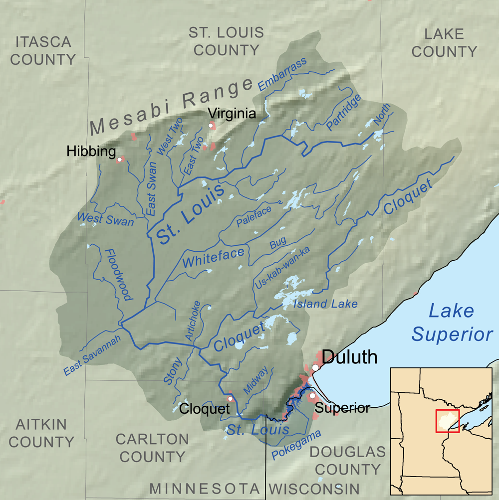
The Saint Louis River (abbreviated St. Louis River) is a river in the U.S. states of Minnesota and Wisconsin that flows into Lake Superior. The largest U.S. river to flow into the lake, it is in lengthU.S. Geological Survey. National Hydrography Dataset high-resolution flowline dataThe National Map accessed May 1, 2012 and starts east of Hoyt Lakes, Minnesota. The river's watershed covers . Near the Twin Ports of Duluth, Minnesota and Superior, Wisconsin, the river becomes a freshwater estuary. History According to Warren Upham, the Ojibwe name of the river is ''Gichigami-ziibi'' (Great-lake River). He notes: "The river was probably so named by Pierre Gaultier de Varennes, sieur de La Vérendrye (1685–1749), who was a very active explorer, in the years 1731 and onward. Shortly before his death the king of France in 1749 conferred on him the cross of Saint Louis as a recognition of the importance of his discoveries, and thence the name of the Saint Louis River appears to ... [...More Info...] [...Related Items...] OR: [Wikipedia] [Google] [Baidu] |
Ontonagon Boulder
The Ontonagon Boulder (/ˌɒntəˈnɑːɡən ˈboʊldəɹ/) is a boulder of native copper originally found in the Upper Peninsula of Michigan, United States, and now in the possession of the Department of Mineral Sciences, National Museum of Natural History, Smithsonian Institution. In 1843 the boulder was purchased from a local entrepreneur and shipped to Washington D.C. The boulder is a relic of Michigan's Upper Peninsula and was well known to Native Americans in its location on the west branch of the Ontonagon River, in what is now Victoria Reservoir. According to the Keweenaw Bay Indian Community, the boulder was used by tribe members to make offerings to its manitou (spirit) and to seek improvement in their health and well-being. Although many attribute the boulder to a relic of Michigan's copper boom, it was not a product of the boom but the reason for it. The copper boom was only fully realized after the boulder had been moved to Washington D.C. Origin While the exact o ... [...More Info...] [...Related Items...] OR: [Wikipedia] [Google] [Baidu] |
Ontonagon River
The Ontonagon River ( ) is a river flowing into Lake Superior at the village of Ontonagon, on the western Upper Peninsula of Michigan in the United States. The main stem of the river is long''The American Rivers Outstanding Rivers List'', Second Edition, May 1991. Compiled and edited by Matthew H. Huntington and John D. Echeverria. Washington, DC: American Rivers, Inc. and is formed by a confluence of several longer branches, portions of which have been collectively designated as a National Wild and Scenic River. Several waterfalls occur on the river including Agate Falls and Bond Falls. Course The Ontonagon River's principal tributaries are its West, South, Middle and East branches, all of which flow in part through the Ottawa National Forest: *The West Branch Ontonagon River is entirely contained in Ontonagon County. It begins at the outlet of Lake Gogebic near the community of Bergland and flows generally east-northeastwardly for approximately ,U.S. Geological Survey. ... [...More Info...] [...Related Items...] OR: [Wikipedia] [Google] [Baidu] |
Keweenaw Peninsula
The Keweenaw Peninsula ( , sometimes locally ) is the northernmost part of Michigan's Upper Peninsula. It projects into Lake Superior and was the site of the first copper boom in the United States, leading to its moniker of "Copper Country." As of the 2000 census, its population was roughly 43,200. Its major industries are now logging and tourism, as well as jobs related to Michigan Technological University and Finlandia University. Geology The peninsula measures about 150 miles in length and about 50 miles in width at its base. The ancient lava flows of the Keweenaw Peninsula were produced during the Mesoproterozoic Era as a part of the Midcontinent Rift between 1.096 and 1.087 billion years ago. This volcanic activity produced the only strata on Earth where large-scale economically recoverable 97 percent pure native copper is found. Much of the native copper found in the Keweenaw comes in either the form of cavity fillings on lava flow surfaces, which has a ”lacy” cons ... [...More Info...] [...Related Items...] OR: [Wikipedia] [Google] [Baidu] |
Michilimackinac
Michilimackinac ( ) is derived from an Ottawa Ojibwe name for present-day Mackinac Island and the region around the Straits of Mackinac between Lake Huron and Lake Michigan.. Early settlers of North America applied the term to the entire region along Lakes Huron, Michigan, and Superior. Today it is considered to be mostly within the boundaries of Michigan, in the United States. Michilimackinac was the original name for present day Mackinac Island and Mackinac County. History Woodland Period (1000 BCE–1650 CE) Pottery first appears during this period in the style of the Laurel complex. The people of the area engaged in long-distance trade, likely as part of the Hopewell tradition. The Anishinaabe and the French (1612–1763) The Straits of Mackinac linking Lakes Michigan and Huron was a strategic area controlling movement between the two lakes and much of the pays d'en haut. It was controlled by Algonquian Anishinaabe nations including the Ojibwa (called Chippewa in ... [...More Info...] [...Related Items...] OR: [Wikipedia] [Google] [Baidu] |
Lake Huron
Lake Huron ( ) is one of the five Great Lakes of North America. Hydrology, Hydrologically, it comprises the easterly portion of Lake Michigan–Huron, having the same surface elevation as Lake Michigan, to which it is connected by the , Straits of Mackinac. It is shared on the north and east by the Canadian province of Ontario and on the south and west by the U.S. state of Michigan. The name of the lake is derived from early French explorers who named it for the Wyandot people, Huron people inhabiting the region. The Huronian glaciation was named from evidence collected from Lake Huron region. The northern parts of the lake include the North Channel (Ontario), North Channel and Georgian Bay. Saginaw Bay is located in the southwest corner of the lake. The main inlet is the St. Marys River (Michigan–Ontario), St. Marys River, and the main outlet is the St. Clair River. Geography By surface area, Lake Huron is the second-largest of the Great Lakes, with a surface area of — ... [...More Info...] [...Related Items...] OR: [Wikipedia] [Google] [Baidu] |
Fort Gratiot Township, Michigan
Fort Gratiot Township ( ) is a charter township of St. Clair County in the U.S. state of Michigan. The population was 11,108 at the 2010 Census. It is named for Fort Gratiot, an American fort located there off and on between 1814 and 1879. History Fort Gratiot Township was established in 1867. It is named for General Charles Gratiot, the engineer who laid out the fort. Communities * Gardendale is an unincorporated community near the center of the township at . It was a station on the Pere Marquette Railway. A post office operated from March 1891 until March 1906. * Keewahdin or Keewahdin Beach was a resort developed in 1914 by the Keewahdin Park Association on Lake Huron north of Port Huron. The name was likely derived from Kewadin, a famous Ojibwe leader. It is located at . * The city of Port Huron is adjacent to the southeast. Geography According to the United States Census Bureau, the township has a total area of , of which is land and (0.19%) is water. Fort Gratiot i ... [...More Info...] [...Related Items...] OR: [Wikipedia] [Google] [Baidu] |
Detroit
Detroit ( , ; , ) is the largest city in the U.S. state of Michigan. It is also the largest U.S. city on the United States–Canada border, and the seat of government of Wayne County. The City of Detroit had a population of 639,111 at the 2020 census, making it the 27th-most populous city in the United States. The metropolitan area, known as Metro Detroit, is home to 4.3 million people, making it the second-largest in the Midwest after the Chicago metropolitan area, and the 14th-largest in the United States. Regarded as a major cultural center, Detroit is known for its contributions to music, art, architecture and design, in addition to its historical automotive background. ''Time'' named Detroit as one of the fifty World's Greatest Places of 2022 to explore. Detroit is a major port on the Detroit River, one of the four major straits that connect the Great Lakes system to the Saint Lawrence Seaway. The City of Detroit anchors the second-largest regional economy in t ... [...More Info...] [...Related Items...] OR: [Wikipedia] [Google] [Baidu] |
Grosse Pointe
Grosse Pointe refers to an affluent coastal area next to Detroit, Michigan, United States, that comprises five adjacent individual cities. From southwest to northeast, they are: *Grosse Pointe Park *Grosse Pointe *Grosse Pointe Farms *Grosse Pointe Shores (incorporated in 2009 from the remnants of two townships: Grosse Pointe Township in Wayne County and Lake Township in Macomb County) * Grosse Pointe Woods The terms "Grosse Pointe" or "the Pointes" are ordinarily used to refer to the entire area, referencing all five individual communities, with a total population of about 46,000. The Grosse Pointes altogether are 10.4 square miles, bordered by Detroit on the south and west, Lake St. Clair on the east and south, Harper Woods on the west of some portions, and St. Clair Shores on the north. The cities are in eastern Wayne County, except for a very small section in Macomb County. The Pointes begin six miles (10 km) northeast of downtown Detroit and extend several miles nort ... [...More Info...] [...Related Items...] OR: [Wikipedia] [Google] [Baidu] |


.jpg)


