|
Lewis And Clark Trail-Travois Road
The Lewis and Clark Trail–Travois Road is a historic site located east of Pomeroy, Washington, on U.S. Route 12 (US 12). It is a surviving stretch of Indian travois trail followed by Lewis and Clark in their 1805–06 expedition and mentioned in their writings. It was listed on the National Register of Historic Places in 1974. and The site is significant for the 1805–06 event, for including "a trail that was very important in aboriginal times", and for its information potential. It seems to have been described by Meriwether Lewis, who wrote on May 3, 1806: "...we Continued Still up the Creek bottoms ... to the place at which the roade leaves the atahaCreek and assends the hill up to the high plains: here we Encamped in a Small grove of Cotton trees...". Travois were used by American Indians to transport possessions by means of two long poles slung with a hammock trailing behind a horse or dog. The deep, parallel tracks caused by the dragging poles are still visible ... [...More Info...] [...Related Items...] OR: [Wikipedia] [Google] [Baidu] |
Pomeroy, Washington
Pomeroy is a city in Garfield County, Washington, United States. The population was 1,425 at the 2010 census. It is the county seat of and only incorporated city in Garfield County. Geography Pomeroy is located at (46.473334, -117.598119). According to the United States Census Bureau, the city has a total area of , all of it land. U.S. Route 12 in Washington serves as the primary highway through town, connecting Pomeroy with the Lewiston–Clarkston metropolitan area (to the east) and the Tri-Cities metro area/ Walla Walla area (to the west). The city is 1,857 ft above sea level in the very hilly region between the Blue Mountains (to the south) and the Palouse region (to the north). The primary highway through town passes over Alpowa Summit (2,785 ft) only a few miles east of town. History The Nez Perce trail existed in the area before history was recorded, and the first written record of caucasians passing through the area were Lewis and Clark in 1805. Captain Benjamin ... [...More Info...] [...Related Items...] OR: [Wikipedia] [Google] [Baidu] |
Travois
A travois (; Canadian French, from French , a frame for restraining horses; also obsolete travoy or travoise) is a historical frame structure that was used by indigenous peoples, notably the Plains Aboriginals of North America, to drag loads over land. There is evidence to support the thesis that travois were used in other parts of the world before the invention of the wheel. Construction and use The basic construction consists of a platform or netting mounted on two long poles, lashed in the shape of an elongated isosceles triangle; the frame was dragged with the sharply pointed end forward. Sometimes the blunt end of the frame was stabilized by a third pole bound across the two poles. The travois was dragged by hand, sometimes fitted with a shoulder harness for more efficient dragging, or dragged by dogs or horses (after the 16th-century introduction of horses by the Spanish). A travois could either be loaded by piling goods atop the bare frame and tying them in place, ... [...More Info...] [...Related Items...] OR: [Wikipedia] [Google] [Baidu] |
Lewis And Clark Expedition
The Lewis and Clark Expedition, also known as the Corps of Discovery Expedition, was the United States expedition to cross the newly acquired western portion of the country after the Louisiana Purchase. The Corps of Discovery was a select group of U.S. Army and civilian volunteers under the command of Captain Meriwether Lewis and his close friend Second Lieutenant William Clark. Clark and 30 members set out from Camp Dubois, Illinois, on May 14, 1804, met Lewis and ten other members of the group in St. Charles, Missouri, then went up the Missouri River. The expedition crossed the Continental Divide of the Americas near the Lemhi Pass, eventually coming to the Columbia River, and the Pacific Ocean in 1805. The return voyage began on March 23, 1806, at Fort Clatsop, Oregon, and ended on September 23 of the same year. President Thomas Jefferson commissioned the expedition shortly after the Louisiana Purchase in 1803 to explore and to map the newly acquired territory, to find a pr ... [...More Info...] [...Related Items...] OR: [Wikipedia] [Google] [Baidu] |
National Register Of Historic Places
The National Register of Historic Places (NRHP) is the United States federal government's official list of districts, sites, buildings, structures and objects deemed worthy of preservation for their historical significance or "great artistic value". A property listed in the National Register, or located within a National Register Historic District, may qualify for tax incentives derived from the total value of expenses incurred in preserving the property. The passage of the National Historic Preservation Act (NHPA) in 1966 established the National Register and the process for adding properties to it. Of the more than one and a half million properties on the National Register, 95,000 are listed individually. The remainder are contributing resources within historic districts. For most of its history, the National Register has been administered by the National Park Service (NPS), an agency within the U.S. Department of the Interior. Its goals are to help property owners and inte ... [...More Info...] [...Related Items...] OR: [Wikipedia] [Google] [Baidu] |
Meriwether Lewis
Meriwether Lewis (August 18, 1774 – October 11, 1809) was an American explorer, soldier, politician, and public administrator, best known for his role as the leader of the Lewis and Clark Expedition, also known as the Corps of Discovery, with William Clark. Their mission was to explore the territory of the Louisiana Purchase, establish trade with, and sovereignty over the natives near the Missouri River, and claim the Pacific Northwest and Oregon Country for the United States before European nations. They also collected scientific data, and information on indigenous nations. President Thomas Jefferson appointed him Governor of Upper Louisiana in 1806. He died of gunshot wounds in what was either a murder or suicide, in 1809. Life and work Meriwether Lewis was born August 18, 1774, on Locust Hill Plantation in Albemarle County, Colony of Virginia, in the present-day community of Ivy. He was the son of William Lewis, of Welsh ancestry, and Lucy Meriwether, of English ancestr ... [...More Info...] [...Related Items...] OR: [Wikipedia] [Google] [Baidu] |
Native Americans In The United States
Native Americans, also known as American Indians, First Americans, Indigenous Americans, and other terms, are the Indigenous peoples of the mainland United States ( Indigenous peoples of Hawaii, Alaska and territories of the United States are generally known by other terms). There are 574 federally recognized tribes living within the US, about half of which are associated with Indian reservations. As defined by the United States Census, "Native Americans" are Indigenous tribes that are originally from the contiguous United States, along with Alaska Natives. Indigenous peoples of the United States who are not listed as American Indian or Alaska Native include Native Hawaiians, Samoan Americans, and the Chamorro people. The US Census groups these peoples as " Native Hawaiian and other Pacific Islanders". European colonization of the Americas, which began in 1492, resulted in a precipitous decline in Native American population because of new diseases, wars, ethni ... [...More Info...] [...Related Items...] OR: [Wikipedia] [Google] [Baidu] |
Nez Perce Trail
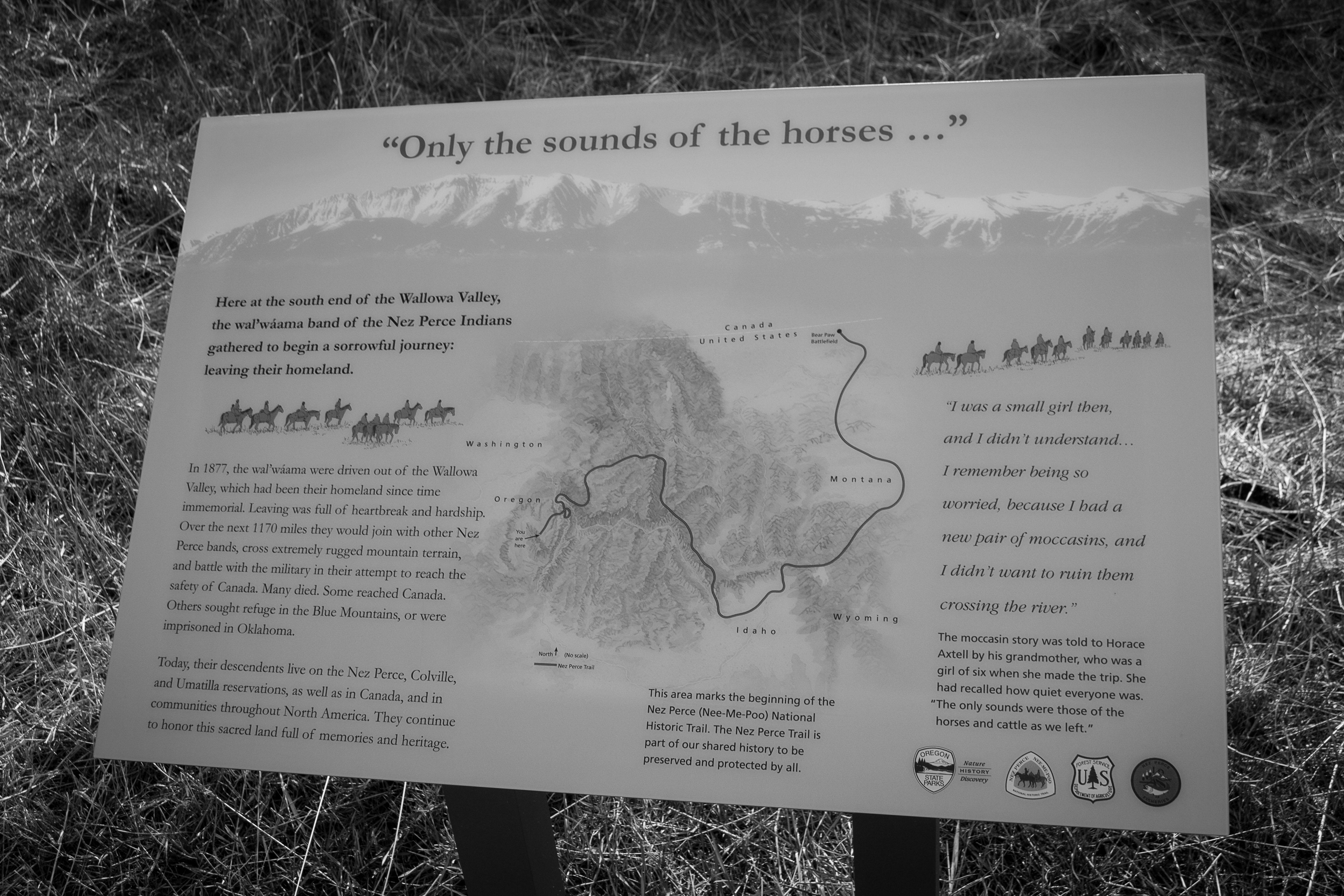
The Nez Perce (Nee-Me-Poo) National Historic Trail follows the route taken by a large group of the Nez Perce tribe in 1877 to avoid being forced onto a reservation. The 1,170-mile (1,883 km) trail was created in 1986 as part of the National Trails System Act and is managed by the U.S. Forest Service. The trail traverses through portions of the U.S. states of Oregon, Idaho, Wyoming, and Montana and connects sites across these states that commemorate significant events of the Nez Perce War that took place between June and October 1877, as several bands of the Nez Perce tried to escape capture by the U.S. Cavalry. The sites are among the 38 that are part of the National Park service's Nez Perce National Historical Park, managed over all by the National Park Service, with some sites managed by local and state affiliated organizations. History A band of 750 Nez Perce warriors and women, children and elders made the journey. They were parties to the 1855 Treaty of Walla Walla with ... [...More Info...] [...Related Items...] OR: [Wikipedia] [Google] [Baidu] |
National Register Of Historic Places In Garfield County, Washington
This is a list of properties and historic districts in Washington that are listed on the National Register of Historic Places. There are at least three listings in each of Washington's 39 counties. The National Register of Historic Places recognizes buildings, structures, objects, sites, and districts of national, state, or local historic significance across the United States. Out of over 90,000 National Register sites nationwide,. more than 1,500 are in Washington. Current listings by county The following are tallies of current listings by county. Notes See also *Historic preservation *History of Washington (state) *National Register of Historic Places *List of National Historic Landmarks in Washington (state) *List of bridges on the National Register of Historic Places in Washington (state) *Index of Washington-related articles References Further reading * Roberts, George; Roberts, Jan (1999). ''Discover Historic Washington State'', Gem Guides Book Company, . Histo ... [...More Info...] [...Related Items...] OR: [Wikipedia] [Google] [Baidu] |


